Castlemaine is a small city in Victoria, Australia, in the goldfields region of Victoria about 120 kilometres northwest by road from Melbourne and about 40 kilometres from the major provincial centre of Bendigo. It is the administrative and economic centre of the Shire of Mount Alexander. The population at the 2016 Census was 6,757. Castlemaine was named by the chief goldfield commissioner, Captain W. Wright, in honour of his Irish uncle, Viscount Castlemaine.

Airport West is a suburb 11 km north-west of Melbourne, Australia. Its local government area is the City of Moonee Valley. At the 2016 census, Airport West had a population of 7,564.
Essendon, is a suburb of Melbourne, Victoria, Australia, 9 km (5.6 mi) north-west of Melbourne's central business district. Its local government area is the City of Moonee Valley. At the 2016 census, Essendon had a population of 20,596.

Kyneton is a town in the Macedon Ranges region of Victoria, Australia. The Calder Freeway bypasses Kyneton to the north and east. The town was named after the English village of Kineton, Warwickshire.

Mount Hotham is a mountain in the Victorian Alps of the Great Dividing Range, located in the Australian state of Victoria. The mountain is located approximately 357 kilometres (222 mi) north east of Melbourne, 746 kilometres (464 mi) from Sydney, and 997 kilometres (620 mi) from Adelaide by road. The nearest major road to mountain is the Great Alpine Road. The mountain is named after Charles Hotham, Governor of Victoria from 1854 to 1855.

Mount Scopus Memorial College, commonly known as Mount Scopus College, is an independent co-educational Modern Orthodox Jewish day school located in the Melbourne suburb of Burwood, Victoria, Australia.

Flemington Road is a major thoroughfare in the inner suburbs of North Melbourne and Parkville in Melbourne, Victoria, Australia. It runs from the north end of Elizabeth Street to the south end of Mount Alexander Road, Flemington, and provides a main connection between the Melbourne CBD and the northern arm of the CityLink tollway.

Major General James William Macarthur-Onslow, was a soldier, grazier and politician. The son of a prominent New South Wales family, he was commissioned in the New South Wales Mounted Rifles in 1892 and served in the Chitral Expedition, Second Boer War and the First World War. Afterwards he served in the New South Wales Legislative Assembly and New South Wales Legislative Council.
The Melbourne, Mount Alexander and Murray River Railway Company was a railway company in Victoria, Australia. It was established on 8 February 1853 to build a railway from Melbourne to Echuca on the Victorian-NSW border and a branch railway to Williamstown. The company struggled to make any progress and on 23 May 1856, the colonial Government took over the Company and it became part of the newly established Department of Railways, part of the Board of Land and Works. The Department of Railways became Victorian Railways in 1859.
Travancore is an inner suburb of Melbourne, Victoria, Australia, 5 km north-west of Melbourne's central business district. Its local government area is the City of Moonee Valley. At the 2016 census, Travancore had a population of 2,480.

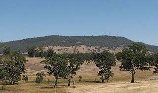
Mount Macedon is a mountain that is part of the Macedon Ranges of the Great Dividing Range, located in the Central Highlands region of Victoria, Australia. The mountain has an elevation of 1,001 metres (3,284 ft) AHD with a prominence of 643 metres (2,110 ft) AHD and is located approximately 65 kilometres (40 mi) northwest of Melbourne.

Essendon tram depot is located on Mount Alexander Road, Travancore, a suburb of Melbourne, Australia. Operated by Yarra Trams, it is one of eight tram depots on the Melbourne tram network. Despite the name, the depot is located three kilometres from the suburb of Essendon.

The Shire of Newstead was a local government area about 120 kilometres (75 mi) northwest of Melbourne, the state capital of Victoria, Australia. The shire covered an area of 409.22 square kilometres (158.0 sq mi), and existed from 1860 until 1995.
Australian rules football was heavily affected by both World War I and World War II. Hundreds of leading players served their country abroad, and many lost their lives. On the home front, competitions like the Victorian Football League (VFL) went ahead during these wars, but faced many restrictions.
North Central Province was an electorate of the Victorian Legislative Council (Australia). It was created in the redistribution of provinces in 1882 when the Central and Eastern Provinces were abolished. The new North Central Province, South Yarra, North Yarra, South Eastern and Melbourne Provinces were then created.

Sandon is a locality in central Victoria, Australia. The locality is split between the Shire of Mount Alexander and the Shire of Hepburn, 106 kilometres (66 mi) north west of the state capital, Melbourne.

Campbelltown is a locality in central Victoria, Australia. The locality is split between the Shire of Hepburn, the Shire of Central Goldfields and the Shire of Mount Alexander, 140 kilometres (87 mi) north west of the state capital, Melbourne.