Mount Coe

Last updated
Mount Coe

Mt Coe.jpg

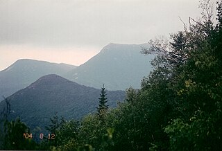
Fir waves on Mount Coe
Highest point
Elevation 3,795 ft (1,157 m) [1]
Prominence 315 ft (96 m) [1]
Listing New England 100 Highest #90
Coordinates 45°56′01″N69°00′32″W / 45.93371°N 69.00901°W / 45.93371; -69.00901 Coordinates: 45°56′01″N69°00′32″W / 45.93371°N 69.00901°W / 45.93371; -69.00901 [2]
Geography
USA Maine location map.svg
Red triangle with thick white border.svg
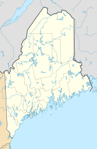
Mount Coe
Location in Maine
Location Piscataquis County, Maine
Topo map USGS Doubletop Mountain
Climbing
Easiest route hiking trail

Mount Coe is a mountain located in Piscataquis County, Maine, within Baxter State Park, about 5.5 mi (9 km) northwest of Mount Katahdin. Mt. Coe is flanked to the northeast by South Brother, and to the southwest by Mount O-J-I. The Mount Coe trail starts at Slide Dam on Newsowdnehunk Stream east bank at around 1,190 ft (360 m). The trail goes up to the east for about 1.2 mi (1.9 km) and then goes right (south) along the drainage from the Mt. Coe slide bending to the east and then northeast. The last 0.5 mi (0.80 km) is up the slide featured on the left margin of the photo where the trail gains around 800 ft (240 m).

Mountain A large landform that rises fairly steeply above the surrounding land over a limited area

A mountain is a large landform that rises above the surrounding land in a limited area, usually in the form of a peak. A mountain is generally steeper than a hill. Mountains are formed through tectonic forces or volcanism. These forces can locally raise the surface of the earth. Mountains erode slowly through the action of rivers, weather conditions, and glaciers. A few mountains are isolated summits, but most occur in huge mountain ranges.

Piscataquis County, Maine County in the United States

Piscataquis County is a county located in the U.S. state of Maine. As of the 2010 census, its population was 17,535, making it Maine's least-populous county. Its county seat is Dover-Foxcroft. The county was incorporated on 23 March 1838, taken from the western part of Penobscot County and the eastern part of Somerset County, and is named for an Abenaki word meaning "branch of the river" or "at the river branch."

Maine State of the United States of America

Maine is a state in the New England region of the northeastern United States. Maine is the 12th smallest by area, the 9th least populous, and the 38th most densely populated of the 50 U.S. states. It is bordered by New Hampshire to the west, the Atlantic Ocean to the southeast, and the Canadian provinces of New Brunswick and Quebec to the northeast and northwest respectively. Maine is the easternmost state in the contiguous United States, and the northernmost state east of the Great Lakes. It is known for its jagged, rocky coastline; low, rolling mountains; heavily forested interior; and picturesque waterways, as well as its seafood cuisine, especially lobster and clams. There is a humid continental climate throughout most of the state, including in coastal areas such as its most populous city of Portland. The capital is Augusta.

Mount Coe, ranked 22nd in height among Maine peaks, stands within the watershed of the Penobscot River, which drains into Penobscot Bay. The east side of Mt. Coe drains into a swampy area called "The Klondike", then into Wassataquoik Stream, and the East Branch of the Penobscot River. The northwest and southwest sides of Mt. Coe drain into Nesowdnehunk Stream, then into the West Branch of the Penobscot River.

Drainage basin Area of land where precipitation collects and drains off into a common outlet

A drainage basin is any area of land where precipitation collects and drains off into a common outlet, such as into a river, bay, or other body of water. The drainage basin includes all the surface water from rain runoff, snowmelt, and nearby streams that run downslope towards the shared outlet, as well as the groundwater underneath the earth's surface. Drainage basins connect into other drainage basins at lower elevations in a hierarchical pattern, with smaller sub-drainage basins, which in turn drain into another common outlet.

Penobscot River river in the US state of Maine

The Penobscot River is a 109-mile-long (175 km) river in the U.S. state of Maine. Including the river's West Branch and South Branch increases the Penobscot's length to 264 miles (425 km), making it the second-longest river system in Maine and the longest entirely in the state. Its drainage basin contains 8,610 square miles (22,300 km2).

Penobscot Bay Bay in Maine, United States

Penobscot Bay is an inlet of the Gulf of Maine and Atlantic Ocean in south central Maine. The bay originates from the mouth of Maine's Penobscot River, downriver from Belfast. Penobscot Bay has many working waterfronts including Rockland, Rockport, and Stonington, and Belfast upriver. Penobscot Bay is between Muscongus Bay and Blue Hill Bay, just west of Acadia National Park.

See also

Related Research Articles

Crocker Mountain (Maine) mountain in United States of America

Crocker Mountain is a 4,228 ft (1,289 m) peak located in Carrabassett Valley, Franklin County, Maine, in the United States. Crocker Mountain is the fourth highest mountain in the state after the Katahdins and Sugarloaf Mountain, and is part of the Appalachian Mountains. Crocker Mountain is traversed by the Appalachian Trail (AT), a 2,170 mi (3,490 km) National Scenic Trail from Georgia to Maine.

Old Speck Mountain mountain in United States of America

Old Speck Mountain, also known as Old Speckle Mountain, is a mountain located in Oxford County, Maine, United States. The mountain, the fourth-highest in the state, is the northeasternmost and highest of the Mahoosuc Range, the northeasternmost part of the White Mountains. Old Speck is flanked to the southwest by Mahoosuc Arm, and faces Baldpate Mountain to the northeast across Grafton Notch.

Mount Abraham (Maine) mountain in United States of America

Mount Abraham is a mountain located in Franklin County, Maine. Mount Abraham is flanked to the north by Spaulding Mountain.

Mount Redington mountain in United States of America

Mount Redington is a mountain located in Franklin County, Maine. Redington is flanked to the northeast by South Crocker Mountain and to the west by Black Nubble. Redington stands just northeast of the U.S. Navy Survival Escape and Evasion Training Facility (USSEAETF).

North Brother mountain in United States of America

North Brother is a mountain located in Baxter State Park, Piscataquis County, Maine. North Brother is flanked to the northeast by Fort Mountain, and to the southwest by South Brother; collectively the two are called "The Brothers."

South Brother mountain in United States of America

South Brother is a mountain located in Piscataquis County, Maine, in Baxter State Park. South Brother is flanked to the southwest by Mount Coe, and to the northeast by North Brother; collectively the two are called "The Brothers".

Spaulding Mountain mountain in United States of America

Spaulding Mountain is a mountain located in Franklin County, Maine. Spaulding Mountain is flanked to the northeast by Sugarloaf Mountain, and to the southeast by Mount Abraham.

White Cap Mountain (Piscataquis County, Maine) mountain in Maine, United States of America

White Cap Mountain is a mountain located in Piscataquis County, Maine. White Cap Mountain is flanked to the east by Hay Mountain, to the south by Big Spruce Mountain and to the southeast by Little Spruce Mountain.

Baldpate Mountain (Maine) mountain in Maine, United States of America

Baldpate Mountain is a mountain located in Oxford County, Maine. Baldpate has two prominent peaks; West Peak has 3,662 feet (1,116 m) of elevation, and stands 222 feet (68 m) above the col between them.

Baker Mountain (Piscataquis County, Maine) mountain in Maine, United States of America

Baker Mountain is a wild, trail-less mountain located in Beaver Cove, Piscataquis County, Maine. It is flanked to the northwest by Lily Bay Mountain. Elephant Mountain is about 2 miles (3 km) to the southwest, and White Cap Mountain is about 5 miles (8 km) to the east.

Elephant Mountain (Oxford County, Maine) mountain in Maine, United States of America

Elephant Mountain is a mountain located in Township C, Oxford County, Maine. Its northeastern end is in Township D, Franklin County. Elephant Mountain is flanked to the northeast by Bemis Mountain, and to the southeast by Old Blue Mountain.

Doubletop Mountain (Maine) mountain in United States of America

Doubletop Mountain is a mountain located in Piscataquis County, Maine, in Baxter State Park. As the name implies, the mountain has two peaks; a north peak and a south peak. From the north a trail from the Nesowednehunk Campground to the north peak is 3.1 miles (5.0 km) long and another 0.2 miles (0.32 km) to the south peak. From Foster Field, to the south, a 4-mile (6.4 km) trail leads to the summit. The last third of mile (0.53 km) is steep and climbs about 900 feet (270 m). The north peak is wooded while the south peak is more open.

Boundary Bald Mountain mountain in United States of America

Boundary Bald Mountain is a mountain located in Somerset County, Maine, about 7.5 mi (12.1 km) southeast of the Canada–US border with Quebec. Boundary Bald Mountain is flanked to the east by Ironbound Mountain, and to the west by Sandy Bay Mountain.

Saddleback Mountain (Piscataquis County, Maine) mountain in Maine, USA

Saddleback Mountain is a mountain located in Piscataquis County, Maine.

Goose Eye Mountain mountain in United States of America

Goose Eye Mountain, also known as Mt. Goose High, is a mountain located in Oxford County, Maine, about 1 mi (1.6 km). (2 km) east of the New Hampshire-Maine border. The mountain is the second-highest peak of the Mahoosuc Range of the White Mountains.

Fort Mountain (Maine) mountain in Maine, United States of America

Fort Mountain is a mountain located in Piscataquis County, Maine, within Baxter State Park. Fort Mountain is flanked to the southeast by North Brother Mountain, and to the north by Mullen Mountain. Although officially trailless, a well-defined herd path leads to the summit of Fort from North Brother.

Rocky Mountain is a peak of the Blue Ridge Mountains in Virginia. It is located about 2 miles (3.5 km) east of Irish Gap, on the border of Rockbridge County and Amherst County; it is the highest point of both counties. Rocky Mountain is flanked to the northeast by Elk Pond Mountain, to the southwest by Grapevine Ridge, and to the south by Tar Jacket Ridge.

Saddleback Junior mountain in United States of America

Saddleback Junior is a mountain located in Franklin County, Maine. Saddleback Junior is flanked to the southwest by Saddleback Horn, and to the northeast by Poplar Ridge. The mountain is on the south border of the U.S. Navy Survival Escape and Evasion Training Facility (USSEAETF).

Baker Branch Saint John River river in the United States of America

The Baker Branch Saint John River is a 48.0-mile-long (77.2 km) river. This river is a tributary of the Saint John River, flowing in the Maine North Woods, in Maine, in the Northeastern United States.

The Southwest Branch Saint John River is a 62.0-mile-long (99.8 km) river in Maine and Quebec. The branch originates in "Little Saint John Lake" on the international boundary between Saint-Zacharie, Quebec and Seboomook Lake Township 5, Range 20, WELS. The branch forms the Canada–United States border as it flows northeasterly to a confluence with the Little Southwest Branch Saint John River in Seboomook Lake Township 9, Range 18, WELS. The Southwest Branch flows briefly into Quebec and then through Maine to its confluence with the Baker Branch Saint John River in Seboomook Lake Township 9, Range 17, WELS. The Southwest Branch finally joins with the Northwest Branch to form the Saint John River.

References

  1. 1 2 "Mount Coe". Peakbagger.com. Retrieved 2007-05-09.
  2. "Mount Coe". Geographic Names Information System . United States Geological Survey . Retrieved 2007-05-09.