
Hong Kong Island is an island in the southern part of Hong Kong. Known colloquially and on road signs simply as Hong Kong,the island had a population of 1,289,500 and a population density of 16,390 per square kilometre (42,400/sq mi),as of 2008. The island had a population of about 3,000 inhabitants scattered in a dozen fishing villages when it was occupied by the United Kingdom in the First Opium War (1839–1842). In 1842,the island was formally ceded in perpetuity to the UK under the Treaty of Nanking and the City of Victoria was then established on the island by the British Force in honour of Queen Victoria. The Central area on the island is the historical,political and economic centre of Hong Kong. The northern coast of the island forms the southern shore of the Victoria Harbour,which is largely responsible for the development of Hong Kong due to its deep waters favoured by large trade ships.

Central is the central business district of Hong Kong. It is located in the northeastern corner of the Central and Western District,on the north shore of Hong Kong Island,across Victoria Harbour from Tsim Sha Tsui,the southernmost point of Kowloon Peninsula. The area was the heart of Victoria City,although that name is rarely used today.

Hong Kong Tramways (HKT) is a 3 ft 6 in narrow-gauge tram system in Hong Kong. Owned and operated by RATP Dev,the tramway runs on Hong Kong Island between Kennedy Town and Shau Kei Wan,with a branch circulating through Happy Valley.

Victoria Peak is a hill on the western half of Hong Kong Island. It is also known as Mount Austin,and locally as The Peak only generally. With an elevation of 552 metres (1,811 ft),it is the tallest hill on Hong Kong Island,and the 29th tallest in the territory of Hong Kong. It is a major tourist attraction offering views of Central,Victoria Harbour,Lamma Island and the surrounding islands.
The City of Victoria,often called Victoria City or simply Victoria,was the de facto capital of Hong Kong during its time as a British dependent territory. It was initially named Queenstown but was soon known as Victoria. It was one of the first urban settlements in Hong Kong and its boundaries are recorded in the Laws of Hong Kong. All government bureaux and many key departments still have their head offices located within its limit.

The Peak Tram is a funicular railway in Hong Kong,which carries both tourists and residents to the upper levels of Hong Kong Island. Running from Garden Road Admiralty to Victoria Peak via the Mid-Levels,it provides the most direct route and offers good views over the harbour and skyscrapers of Hong Kong. Operated since 1888,it was the first funicular railway in Asia.

Mid-Levels is an affluent residential area on Hong Kong Island in Hong Kong. It is located between Victoria Peak and Central. Residents are predominantly more affluent Hong Kong locals and expatriate professionals.

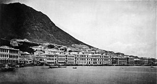
Sheung Wan is an area in Hong Kong,located in the north-west of Hong Kong Island,between Central and Sai Ying Pun. Administratively,it is part of the Central and Western District. The name can be variously interpreted as Upper District,or Gateway District.

Shek Kip Mei,originally known as Shek Kap Mei, is an area in New Kowloon,to the northeast of the Kowloon Peninsula of Hong Kong. It borders Sham Shui Po and Kowloon Tong.

Happy Valley is an upper-income residential area in Hong Kong,located on Hong Kong Island. The area is bordered by Caroline Hill to the east,Jardine's Lookout to the south,Morrison Hill to the west,and Causeway Bay to the north. Administratively,it is part of Wan Chai District.

Kennedy Town is at the western end of Sai Wan on Hong Kong Island in Hong Kong. It was named after Arthur Edward Kennedy,the 7th Governor of Hong Kong from 1872 to 1877. Administratively,it is part of Central and Western District.

The Hong Kong Academy for Performing Arts (HKAPA) is a provider of tertiary education in Hong Kong. Located near the north coast of Wan Chai on Hong Kong Island,the main campus also functions as a venue for performances. Apart from the main campus in Wan Chai,Bethanie,the site of the institution's Landmark Heritage Campus in Pok Fu Lam,has housed the School of Film and Television since 2007.

Ma Tau Kok is a place north of To Kwa Wan,south-east of modern-day Ma Tau Chung and south-west of the former Kai Tak Airport in Hong Kong. It was a cape in Kowloon Bay in Victoria Harbour and opposite to the Sacred Hill and the mouth of Ma Tau Chung. Ma Tau Kok is a mixed industrial and residential area.

Kennedy Road is a road in the Mid-Levels on Hong Kong Island,Hong Kong. It is named after Arthur Kennedy,the seventh governor of Hong Kong.
Articles related to Hong Kong include:
The Central and Western District located on northwestern part of Hong Kong Island is one of the 18 administrative districts of Hong Kong. It had a population of 243,266 in 2016. The district has the most educated residents with the second highest income and the third lowest population due to its relatively small size.

The Peak District Reservation Ordinance 1904,originally enacted as the Hill District Reservation Ordinance,is commonly called the Peak Reservation Ordinance and was a zoning law that reserved most of the Victoria Peak as a place of residence to non-Chinese people except with the consent of the Governor-in-Council. The law was in force from 1904 to 1930 where the deadly Third Pandemic of Bubonic plague took place in China,causing 100,000 deaths,and enormous number of Chinese influxed into Hong Kong,causing the 1894 Hong Kong plague. Contemporary historians’views toward the Ordinance vary,with some attributing the Ordinance to health segregation,whereas others attribute it to social status segregation. The debate on the second reading of the Bill is recorded in the Hong Kong Hansard,which shows that the two Chinese members,Ho Kai and Wei Yuk,did not oppose the Bill but a minority of the "leading Chinese" in the community were against it.

Mount Cameron is a 439-metre (1,440 ft) high hill in Hong Kong. Located within the Aberdeen Country Park,it was likely named for Major General William Gordon Cameron,British Army officer and former Administrator of Hong Kong.

Lung Fu Shan or Hill Above Belcher's is a 831-foot (253 m) hill on the northwestern part of Hong Kong Island,Hong Kong,and an area on the northeastern slope of the hill where the main campus and centennial campus of the University of Hong Kong are located.

The University of Chicago Hong Kong,officially The Hong Kong Jockey Club University of Chicago Academic Complex and The University of Chicago Francis and Rose Yuen Campus in Hong Kong,is a satellite campus of the University of Chicago in Mount Davis,Hong Kong,China.


