
Mount Washburn, elevation 10,243 feet (3,122 m), is a prominent mountain peak in the Washburn Range in Yellowstone National Park, Wyoming. The peak was named in 1870 to honor Henry D. Washburn, leader of the Washburn–Langford–Doane Expedition. The Washburn Range is one of two mountains ranges completely within the boundaries of Yellowstone.
Gray Peak el. 10,298 feet (3,139 m) is a prominent mountain peak in the Gallatin Range in the remote northwest section of Yellowstone National Park, Wyoming. The peak is approximately 9.1 miles (14.6 km) west-southwest of Mammoth Hot Springs and 8.9 miles (14.3 km) north of Mount Holmes. There are no maintained trails to the summit. The closest maintained trail is the Fawn Pass Trail which skirts the southern face approximately 1 mile (1.6 km) south of the peak.

Eagle Peak is a mountain in the Absaroka Range in the U.S. state of Wyoming and at 11,372 feet (3,466 m) is the highest point in Yellowstone National Park. It is located about 6 miles (9.7 km) east of the southeast arm of Yellowstone Lake.

Mount Holmes is a prominent mountain peak in Yellowstone National Park. It is the tallest mountain in the Wyoming portion of the Gallatin Range. Mount Holmes is located in the northwestern part of the park and marks the southern terminus of the Gallatin Range. It is the source of Indian Creek, a tributary of the Gardner River.

The following articles relate to the history, geography, geology, flora, fauna, structures and recreation in Yellowstone National Park.

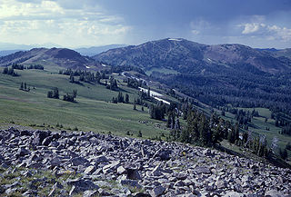
Mount Haynes el. 8,218 feet (2,505 m) is a prominent peak adjacent to the Madison River in Yellowstone National Park. The peak was named by then Yellowstone superintendent Horace Albright to honor Frank Jay Haynes (1853–1921), the first official photographer of the park. Prior to being named Mount Haynes, the peak was unofficially called Mount Burley for D. E. Burley of the Union Pacific Railroad. Today there is an interpretive overlook along the Madison River just opposite the peak.

Mount Sheridan el. 10,313 feet (3,143 m) is a prominent mountain peak overlooking Heart Lake in the Red Mountains of Yellowstone National Park. The peak is named in honor of General Philip H. Sheridan, U.S. Army, one of the early protectors of the park.

Mount Schurz el. 11,007 feet (3,355 m) is a mountain peak in the Absaroka Range in Yellowstone National Park. Mount Schurz is the second highest peak in Yellowstone. The mountain was originally named Mount Doane by Henry D. Washburn during the Washburn–Langford–Doane Expedition in 1871. Later the name Mount Doane was given to another peak in the Absaroka Range by geologist Arnold Hague. In 1885, Hague named the mountain for the 13th U.S. Secretary of the Interior, Carl Schurz (1877–1881). Schurz was the first Secretary of the Interior to visit Yellowstone and a strong supporter of the national park movement.

Mount Doane el. 10,551 feet (3,216 m) is a mountain peak in the Absaroka Range in Yellowstone National Park. The peak is named for Lieutenant Gustavus Cheyney Doane, a U.S. Army cavalry officer who escorted the Washburn-Langford-Doane Expedition into Yellowstone in 1870. During that expedition, Doane and Nathaniel P. Langford ascended several peaks east of Yellowstone Lake.

Mount Jackson el. 8,231 feet (2,509 m) is a mountain peak just north of the Madison River, in the Gallatin Range of Yellowstone National Park. Mount Jackson is named in honor of William Henry Jackson, chief photographer of the Hayden Geological Survey of 1871 and a member of several subsequent geological surveys in the park. Jackson's photographs are some of the earliest ever taken in Yellowstone. The name was suggested by a park naturalist in 1935 but not awarded until 1937 when Jackson, who was still living gave his approval. Jackson visited the park regularly until his death in 1942.

Factory Hill el. 9,527 feet (2,904 m) is a mountain peak in the Red Mountains of Yellowstone National Park. It is directly north of Mount Sheridan and west of the Heart Lake Geyser Basin. Early in the history of Yellowstone, this peak was call Red Mountain by the Hayden surveys, a name later transferred to the range in which it resides. In 1885, the Hague Geological Survey gave the peak its present name based on the following passage by Nathaniel P. Langford in his 1871 Scribner's account of the Washburn–Langford–Doane Expedition. Langford's party was camped near the south arm of Yellowstone Lake at the time.

Mount Langford el. 10,623 feet (3,238 m) is a mountain peak in the Absaroka Range in Yellowstone National Park. The peak is named for Nathaniel P. Langford, the first superintendent of Yellowstone and a leader of the Washburn–Langford–Doane Expedition to Yellowstone in 1870. The expedition and Langford's subsequent promotion in Scribner's helped in the creation of the park in 1872.

Mount Norris el. 9,842 feet (3,000 m) is a mountain peak in the northeast section of Yellowstone National Park in the Absaroka Range. In 1875, the peak was named for and named by Philetus Norris, the second park superintendent (1877–1882). Norris was on a visit to the park with several mountain guides, including Collins Jack Yellowstone Jack Baronette. They ascended the peak at the head of the Lamar Valley and presumed they were the first white men to do so, thus naming it Mount Norris.
Mount Chittenden el. 10,182 feet (3,103 m) is a mountain peak in the Absaroka Range in Yellowstone National Park. The peak was named by Henry Gannett of the Hayden Geological Survey of 1878 for George B. Chittenden. Chittenden was a Geological Survey member who had worked with Gannett, Hayden and others in surveys in Montana, Idaho and Wyoming. Chittenden never participated in any of the Yellowstone surveys.

Dunraven Peak el. 9,869 feet (3,008 m) is a mountain peak in the Washburn Range of Yellowstone National Park. In 1874, just two years after the park's creation, the Earl of Dunraven, a titled Englishman made a visit to Yellowstone in conjunction with a hunting expedition led by Texas Jack Omohundro to the Northern Rockies. He was so impressed with the park, that he devoted well over 150 pages to Yellowstone in his The Great Divide, published in London in 1874. The Great Divide was one of the earliest works to praise and publicize the park.

The Thunderer el. 10,558 feet (3,218 m) is a mountain peak in the northeast section of Yellowstone National Park in the Absaroka Range. The Thunderer, named by members of the Arnold Hague Geological Survey of 1885 for it propensity to attract thunderstorms is a long high ridge just north of Mount Norris. Prior to 1885, the peak was considered just a high ridge extending north from Mount Norris. The Thunderer is easily visible from the northeast entrance road as it passes up the Soda Butte Creek canyon.

Druid Peak is a moderate domed peak on the southern flank of the Absaroka Range in Yellowstone National Park. The peak lies just north of the Lamar River and Soda Butte Creek confluence at the head of the Lamar Valley. Prior to 1885, this summit was named Soda Hill by members of the Hayden Geological Survey of 1878 and Mount Longfellow or Longfellows' Peak by then park superintendent Philetus Norris in 1880. In 1885, members of the Arnold Hague Geological Survey changed the name to Druid Peak for unknown reasons, but some historians believe it may have been the presence of Stonehenge like rock formations on its eastern face that prompted the name.
Mount Stevenson el. 10,230 feet (3,120 m) is a mountain peak in the Absaroka Range of Yellowstone National Park. Mount Stevenson was named in 1871 by geologist Ferdinand Hayden during the Hayden Geological Survey of 1871 for his friend and chief assistant, James Stevenson (1840–1888). Stevenson, who had run away from home as a young boy, first met Hayden in 1853 during an exploration of the Dakota Badlands. In 1866, Stevenson began working for Hayden and did so until 1879. Hayden specifically cited Stevenson's loyalty to him in his 1872 report on the 1871 survey of the park. Stevenson Island on Yellowstone Lake is also named for James Stevenson.
My principal assistant, Mr. James Stevenson, labored with his usual efficiency and fidelity throughout the entire trip. In honor of his great services not only during the past season, but for over twelve years of unremitting toil as my assistant, oftentimes without pecuniary reward, and with little of the scientific recognition that uaually comes to the original explorer, I have desired that one of the principal islands of the lake and one of the noble peaks reflected in its clear waters should bear his name forever.

Mount Hancock el. 10,223 feet (3,116 m) is an isolated mountain peak on Big Game Ridge in Yellowstone National Park. Captain John W. Barlow named the peak in honor of General Winfield Scott Hancock during the Barlow-Heap Exploration of Yellowstone in 1871. General Hancock is noted for issuing the orders that established the military escort led by Lt. Gustavus Cheyney Doane for the Washburn–Langford–Doane Expedition of 1870.
Prospect Peak el. 9,527 feet (2,904 m) is a mountain peak in the Washburn Range of Yellowstone National Park. The summit is located approximately 6 miles (9.7 km) west southwest of Tower Junction. Between 1883-85, members of the Arnold Hague Geological Surveys named the peak Surprise Peak for reasons not now known. In 1880, then superintendent Philetus Norris had named the peak Mount Stephans for one of his assistants, C. N. Stephans. However, in 1885 Arnold Hague, for reasons again not known today, gave the peak its present name—Prospect Peak. The USGS has also mapped this summit as Mount Stephens. and also cited Surprise Peak as an alternate name.


