In geology, a massif is a section of a planet's crust that is demarcated by faults or flexures. In the movement of the crust, a massif tends to retain its internal structure while being displaced as a whole. The term also refers to a group of mountains formed by such a structure.

The Garibaldi Volcanic Belt is a northwest-southeast trending volcanic chain in the Pacific Ranges of the Coast Mountains that extends from Watts Point in the south to the Ha-Iltzuk Icefield in the north. This chain of volcanoes is located in southwestern British Columbia, Canada. It forms the northernmost segment of the Cascade Volcanic Arc, which includes Mount St. Helens and Mount Baker. Most volcanoes of the Garibaldi chain are dormant stratovolcanoes and subglacial volcanoes that have been eroded by glacial ice. Less common volcanic landforms include cinder cones, volcanic plugs, lava domes and calderas. These diverse formations were created by different styles of volcanic activity, including Peléan and Plinian eruptions.

The Pacific Ranges are the southernmost subdivision of the Coast Mountains portion of the Pacific Cordillera. Located entirely within British Columbia, Canada, they run northwest from the lower stretches of the Fraser River to Bella Coola and Burke Channel, north of which are the Kitimat Ranges. The Coast Mountains lie between the Interior Plateau and the Coast of British Columbia.
Meager or Meagre may refer to:

Mount Silverthrone, officially named Silverthrone Mountain, is a mountain in the Pacific Ranges of the Coast Mountains of British Columbia, Canada, located over 320 km (200 mi) northwest of the city of Vancouver and about 50 km (30 mi) west of Mount Waddington, British Columbia, Canada. It is the highest peak in the Ha-Iltzuk Icefield, which is the largest icefield in the Coast Mountains south of the Alaska Panhandle.
The Devastator may refer to:

Devastator Peak, also known as The Devastator, is the lowest and southernmost of the six subsidiary peaks that form the Mount Meager massif in southwestern British Columbia, Canada. It is located 55 km (34 mi) west of Bralorne.
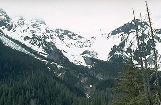
Mount Job is one of six named volcanic peaks of the Mount Meager massif in British Columbia, Canada. It is a pile of rubble held together by volcanic ash and sand. The main summit of Mount Job is hard to climb because of difficult access and its horribly loose rock.

Plinth Peak, sometimes called Plinth Mountain, is the highest satellite cone of the Mount Meager massif, and one of four overlapping volcanic cones which together form a large volcanic complex in the Garibaldi Volcanic Belt of the Canadian Cascade Arc. It is one of the most recently formed volcanic formations of the Mount Meager massif.
Capricorn Mountain is one of the several volcanic peaks of the Mount Meager massif in southwestern British Columbia, Canada. The slopes of Capricorn Mountain appear to be more gentle than other volcanic peaks of the massif. The mountain consists of a boomerang-shaped ridge, with one summit on each end of the boomerang and the main summit in the centre.
Pylon Peak is the southernmost of six named volcanic peaks comprising the Mount Meager massif in British Columbia, Canada. Two pinnacled ridges extend from Pylon and are named respectively the Pylons and the Marionettes. Pylon Peak overlooks the Meager Creek Hot Springs.
Castle Rock is a volcanic plug located 13 km (8 mi) west of Iskut and 8 km northwest of Tuktsayda Mountain in British Columbia, Canada. Castle Rock is part of the Pacific Ring of Fire that includes over 160 active volcanoes and is in the Klastline Group, Northern Cordilleran Volcanic Province and last erupted in the Pleistocene.
Perkin's Pillar was a vertical pillar of volcanic rock of the Mount Meager massif in southwestern British Columbia, Canada. It existed on the steep north flank of Capricorn Mountain. The upper half of Perkin's Pillar broke sometime in June 2005 and only a jagged sliver remains of the previously mighty summit.

Meager Creek is a creek in the southern Pacific Ranges of the Coast Mountains in British Columbia, Canada. It flows northeast into the Lillooet River approximately 95 km (59 mi) northwest of the village of Pemberton and is adjacent to the Upper Lillooet Provincial Park.
The Plinth Assemblage, also known as the Plinth Formation, is an accreted terrane of igneous rocks in southwestern British Columbia, Canada, located just north of the Lillooet River and on the northern flank of the Mount Meager massif. It is named after Plinth Peak, a peak made of Plinth Assemblage rocks.

The Mosaic Assemblage is a rock unit of the Pacific Ranges of the Coast Mountains in southwestern British Columbia, Canada. It is the namesake of Mosaic Glacier, which is drained by Mosaic Creek. This geological formation formed 140,000 to less than 90,000 years ago when porphyritic plagioclase-augite-olivine basalt and trachybasalt was erupted in valleys and on mountain ridges. These volcanic rocks form scoriaceous lava flows, breccias, volcanic bombs and pillow lavas.
The Capricorn Assemblage, also known as the Capricorn Formation, is a geological formation comprising the central portion of the Mount Meager massif in southwestern British Columbia, Canada. It is named after Capricorn Mountain, the third highest subsidiary peak of Meager. The assemblage was formed during a period of volcanic activity about or less than 90,000 years ago.

The 2010 Mount Meager landslide was a large catastrophic debris avalanche that occurred in southwestern British Columbia, Canada, on August 6 at 3:27 a.m. PDT (UTC-7). Over 45,000,000 m3 (1.6×10⁹ cu ft) of debris slid down Mount Meager, temporarily blocking Meager Creek and destroying local bridges, roads and equipment. It was one of the largest landslides in Canadian history and one of over 20 landslides to have occurred from the Mount Meager massif in the last 10,000 years.
