Mount Nelson, Tasmania

Last updated

Mount Nelson
kriwalayti (Southeast Tasmanian)
Hobart,  Tasmania
Mount Nelson Signal Station Cafe.jpg
Mount Nelson Signal Station Cafe
Australia Hobart location map.svg
Red pog.svg
Mount Nelson
Mount Nelson, Tasmania
Coordinates 42°55′15″S147°19′23″E / 42.92083°S 147.32306°E / -42.92083; 147.32306
Population2,749 (2021 census) [1]
Postcode(s) 7007
LGA(s) City of Hobart, Kingborough Council
State electorate(s) Clark
Federal division(s) Clark
Suburbs around Mount Nelson:
Tolmans Hill Sandy Bay Sandy Bay
Ridgeway Mount Nelson Sandy Bay
The LeaAlbion Heights Taroona

Mount Nelson (Nuenonne/palawa kani: kriwalayti) [2] is a mountain suburb situated on the southern boundary of the city of Hobart, Tasmania, Australia. Positioned to the south of Hobart's CBD, Mount Nelson offers panoramic views of the scenic Derwent estuary and surrounds. With an estimated resident population of 2,766 as of 2022, Mount Nelson contains a population density of 421.7 persons per square kilometre. [3]

Contents

The suburb is frequented by tourists visiting the historic Mount Nelson Signal Station, the Truganini Conservation Area, and students attending educational facilities including Hobart College and the Sustainability Learning Centre. It also offers sporting amenities including the University Soccer Club and Mount Nelson Oval.

History

Little is known about the Nuenonne nation, whose territory encompassed Mount Nelson and numerous inner-suburbs of Hobart. The Nuenonne people were profoundly affected by British colonisation starting in 1803, resulting in a substantial decrease in the Aboriginal Tasmanian population. Colonial official and pastor George Augustus Robinson, accompanied by Aboriginal guide Wurati, gained insights into the indigenous languages and naming conventions of the region during his 1830-31 expedition to the island's northeast. Wurati shared with Robinson various names for places, tribes, and people on the expedition, including the name "kriwalayti" from the Bruny Island language. Robinson documented this term in his manuscripts, associating it with name of Mount Nelson, which can be observed from Bruny Island. The latter part of "kriwalayti" signifies a variation of a southeastern word denoting 'hill', 'mountain', or 'peak', which echoes in other local toponyms. Notably, both the Nuenonne and Muwinina tribes of the Hobart and Sandy Bay areas belonged to the broader southeastern language group, threading cultural and linguistic ties of the region. "kriwalayti" has since been adopted by contemporary Palawa peoples in the reconstructed palawa kani language. [2]

Painting of Mount Nelson by Joseph Lycett (1825) Joseph Lycett - Mount Nelson near Hobart Town (1825).jpg
Painting of Mount Nelson by Joseph Lycett (1825)

During the HMS Bounty's visit to the island in 1792, then known as Van Diemens Land, en route to Tahiti, the mountain was dubbed "Nelson's Hill" by Captain William Bligh, in tribute to the ship's esteemed botanist, David Nelson. Tragically, Nelson, a steadfast member of Bligh's crew during the infamous mutiny, met his demise in Kupang, Timor, in 1789, succumbing to an inflammatory fever following the grueling open-boat voyage post-mutiny. [4] [5]

Modern Developments

Significant suburban development in Mount Nelson commenced post-1945, driven by government initiatives to settle immigrants seeking refuge from the devastation wrought by World War II in Europe. This period witnessed the transformation of Mount Nelson into a thriving residential area. Additionally, the former firing range situated north of the bends on Nelson Road underwent conversion into university farmland for the University of Tasmania.

A Rialannah Post Office opened on 1 April 1948 and was renamed Mount Nelson in 1956. It closed in 1971. [6]

In 1967 a large number of houses were destroyed by the Black Tuesday Bushfires. [7]

Signal Station

Governor Lachlan Macquarie's visit to Van Diemen's Land in 1811 led to the establishment of a signal post atop Mount Nelson. This post served to announce the arrival of ships entering the estuary. The semaphore technology at the signal station became obsolete with the introduction of Tasmania's inaugural telephone line in 1880, linking the Mount Nelson signal station to the Hobart telegraph office.

Mount Nelson Signal Station Vista Mount Nelson Signal Station Vista.jpg
Mount Nelson Signal Station Vista

Adjacent to the Signal Station stands the Signal Station Brasserie, housed in the original head signalman’s residence built in 1897.

Historically, signaling operations evolved from flag-based systems to semaphores, with a notable upgrade in 1838 to a towering six-armed semaphore capable of transmitting over 900,000 distinct signals. This network facilitated rapid communication between the penal settlement at Port Arthur and Hobart. Signalmen, often accompanied by their families, endured varying weather conditions, working in shifts from 6 am to 9 pm.

In 1880, Tasmania's first telephone line replaced the semaphore, marking the advent of modern telecommunications. Despite technological advancements, the station continued to play a crucial role, hosting a base station for ship-to-shore radio-telephone communication in 1958. However, operations ceased in 1969, ending 158 years of communication history.

Since 1979, management of the Mount Nelson site has been under the purview of the Parks and Wildlife Service. Today, the station maintains ties to its heritage, flying the Tasmanian State flag daily and utilising International maritime signal flags to welcome ships and mark special occasions. [8]

Geography

Geographically, Mount Nelson is positioned with its short northern boundary abutting the suburb area of Sandy Bay and extending through the University of Tasmania to Churchill Avenue. The northeast boundary follows Lambert Rivulet, traversing through the Skyline and Mount Nelson Signal Station Reserve, while the southern border adjoins the Kingborough Council.

Mount Nelson Oval Mount Nelson Oval.jpg
Mount Nelson Oval

Internally, the suburb of Mount Nelson is bordered by the areas of Fern Tree, Dynnyrne, Ridgeway, and Tolmans Hill, as well as the Southern Outlet. This unique geographic placement offers residents a harmonious blend of urban convenience and natural beauty.

The suburb of Mount Nelson spans approximately 5.9 square kilometres, encompassing 14 parklands covering nearly 16.3% of its total area. Constructed in 1908 to provide better access to the Mount Nelson signal station, the main road in Mount Nelson is Nelson Road, which extends up the mountain from the Wrest Point Hotel Casino into the Sandy Bay suburb. [9] [10]

Truganini Conservation Area

Named after Nuennonne woman Truganini, the Truganini Conservation Area protects native bushland on Mount Nelson's southeast flank. A 90-minute bushwalk (4.2-kilometre (2.6 mi)) from the Signal Station to Sandy Bay offers glimpses of diverse vegetation, a Truganini Memorial, and opportunities to spot wildflowers and native birds, including the endangered swift parrot. [11]

Wildlife

Mount Nelson plays a vital role in the conservation of wildlife, particularly the endangered Swift parrot. Recognized as one of the breeding grounds for this species, Mount Nelson supports efforts to protect and preserve the habitat of these magnificent birds. With an estimated population of around 1000 breeding pairs, conservation initiatives aim to ensure the survival and sustainability of the Swift parrot population in the region. [12]

Demographics

In 2021, the predominant age group in Mount Nelson is 40 years with 2.5 residents per household. [13]

Facilities

Mount Nelson is served by the Mount Nelson Medical Centre, a general store, and pharmacy. The Mount Nelson Fire Station is situated at 40 Olinda Grove.

Educational facilities

Mount Nelson Primary School Mount Nelson Primary School.jpg
Mount Nelson Primary School

Mount Nelson boasts several educational institutions, including Hobart College, one of the city's four public secondary colleges. Notably, Queen Mary of Denmark, wife of Frederik X, is an alumna of Hobart College. [14] Furthermore, Mount Nelson is home to Mount Nelson Primary School, catering to approximately 200 students from Kindergarten to Grade 6. The school serves as a feeder to Taroona High School and encompasses students from Mount Nelson and Tolmans Hill.

Access

Mount Nelson is accessible via Proctors Road off the Southern Outlet and Nelson Road commencing in Sandy Bay. The suburb is serviced by Metro Tasmania bus routes 457, 458, X58 [15] and school routes direct to Hobart College 412, 413, 415 and 417. [16]

Related Research Articles

Protected areas of Tasmania consist of protected areas located within Tasmania and its immediate onshore waters, including Macquarie Island. It includes areas of crown land managed by Tasmanian Government agencies as well as private reserves. As of 2016, 52% of Tasmania's land area has some form of reservation classification, the majority is managed by the Tasmania Parks & Wildlife Service. Marine protected areas cover about 7.9% of state waters.

<span class="mw-page-title-main">Tasman National Park</span> Protected area in Tasmania, Australia

The Tasman National Park is a national park in eastern Tasmania, Australia, approximately 56 kilometres (35 mi) east of Hobart. The 107.5-square-kilometre (41.5 sq mi) park is situated on part of both the Forestier and Tasman peninsulas and encompasses all of Tasman Island.

Councils of Tasmania are the 29 administrative districts of the Australian state of Tasmania. Local government areas (LGAs), more generally known as councils, are the tier of government responsible for the management of local duties such as road maintenance, town planning and waste management.

<span class="mw-page-title-main">Aboriginal Tasmanians</span> Indigenous people of the Australian island state of Tasmania

The Aboriginal Tasmanians are the Aboriginal people of the Australian island of Tasmania, located south of the mainland. For much of the 20th century, the Tasmanian Aboriginal people were widely, and erroneously, thought of as being an extinct cultural and ethnic group that had been intentionally exterminated by white settlers. Contemporary figures (2016) for the number of people of Tasmanian Aboriginal descent vary according to the criteria used to determine this identity, ranging from 6,000 to over 23,000.

<span class="mw-page-title-main">Mount Wellington (Tasmania)</span> Mountain in Tasmania, Australia

Mount Wellington, also known as kunanyi and gazetted as kunanyi / Mount Wellington is a mountain in the south-east of Tasmania, Australia. It is the summit of the Wellington Range and is within Wellington Park reserve. Hobart, Tasmania's capital city, is located at the foot of the mountain.

<span class="mw-page-title-main">Truganini</span> Last full-blooded Palawa person

Truganini, also known as Lallah Rookh was an Aboriginal Tasmanian woman. She was one of the last native speakers of the Tasmanian languages and one of the last individuals solely of Aboriginal Tasmanian descent.

The history of Tasmania begins at the end of the Last Glacial Period when it is believed that the island was joined to the Australian mainland. Little is known of the human history of the island until the British colonisation of Tasmania in the 19th century.

<span class="mw-page-title-main">Bruny Island</span> Island off the coast of Tasmania

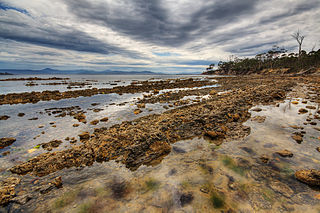
Bruny Island is a 362-square-kilometre (140 sq mi) island located off the southeastern coast of Tasmania, Australia. The island is separated from the Tasmanian mainland by the D'Entrecasteaux Channel, and its east coast lies within the Tasman Sea. Located to the island's northeast Storm Bay, is the river mouth to the Derwent River estuary, and serves as the main port of Hobart, Tasmania's capital city. Both the island and the channel are named after French explorer, Antoine Bruni d'Entrecasteaux. Its traditional Aboriginal name is lunawanna-allonah, which survives as the name of two island settlements, Alonnah and Lunawanna.

<span class="mw-page-title-main">Blackmans Bay, Tasmania</span> Suburb of Hobart, Tasmania, Australia

Blackmans Bay is a coastal suburb of Kingborough Council, Tasmania, Australia. It forms part of the Kingston-Blackmans Bay urban area and is a satellite town of Greater Hobart. It borders Kingston Beach to the north, Maranoa Heights and the Peter Murrell Conservation Area to the west and Howden and Tinderbox to the south.

<span class="mw-page-title-main">City of Hobart</span> Local government area in Tasmania, Australia

Hobart City Council is a local government body in Tasmania, covering the central metropolitan area of the state capital, Hobart. The Hobart local government area has a population of 53,684 and includes the suburbs of West Hobart, Lenah Valley, Mount Stuart, South Hobart, New Town, Sandy Bay and most of Fern Tree, North Hobart and Mount Nelson.

<span class="mw-page-title-main">Wrest Point Hotel Casino</span> Building in Tasmania, Australia

The Wrest Point Hotel Casino is a casino in Tasmania. It was Australia's first legal casino, opening in the suburb of Sandy Bay in Hobart, on 10 February 1973.

<span class="mw-page-title-main">Sandy Bay, Tasmania</span> Suburb of Hobart, Tasmania, Australia

Sandy Bay is a suburb of the city of Hobart, Tasmania, Australia, located immediately south of the central business district, and adjoining the suburb of Battery Point. Sandy Bay is bounded on the east by the Derwent River, and has several beaches along the shore, the main beaches with public access are Short Beach, Nutgrove Beach, Long Beach and Lords Beach.

<span class="mw-page-title-main">Lake Burbury</span> Lake in Tasmania, Australia

Lake Burbury is a man-made water reservoir created by the Crotty Dam inundating the upper King River valley that lies east of the West Coast Range. Discharge from the reservoir feeds the John Butters Hydroelectric Power Station, owned and operated by Hydro Tasmania.

<span class="mw-page-title-main">Dynnyrne, Tasmania</span> Suburb of Hobart, Tasmania, Australia

Dynnyrne is a residential locality in the local government area (LGA) of Hobart in the Hobart LGA region of Tasmania. The locality is about 3 kilometres (1.9 mi) south-west of the town of Hobart. The 2016 census recorded a population of 1577 for the state suburb of Dynnyrne.

Ridgeway is a rural / residential locality in the local government area (LGA) of Hobart in the Hobart LGA region of Tasmania. The locality is about 7 kilometres (4.3 mi) south-west of the town of Hobart. The 2016 census recorded a population of 175 for the state suburb of Ridgeway. It is a suburb of Hobart, located south of Dynnyrne.

Barnes Bay is a rural locality on Bruny Island in the local government area (LGA) of Kingborough in the Hobart LGA region of Tasmania. The locality is about 35 kilometres (22 mi) south of the town of Kingston. The 2016 census recorded a population of 22 for the state suburb of Barnes Bay.

<span class="mw-page-title-main">Lunawanna, Tasmania</span> Town in Tasmania, Australia

Lunawanna is a small township on the western side of Bruny Island, Tasmania, facing the D'Entrecasteaux Channel. It is named after part of the Tasmanian Aboriginal name for Bruny Island, Lunawanna-alonnah, a nearby township about 5 kilometres (3.1 mi) to its north being named Alonnah.

<span class="mw-page-title-main">Kettering, Tasmania</span> Town in Tasmania, Australia

Kettering is a coastal town on the D'Entrecasteaux Channel opposite Bruny Island, Tasmania, Australia. At the 2011 census, Kettering had a population of 984.

Bruny Island Tasmanian, or Nuenonne ("Nyunoni"), a name shared with Southeast Tasmanian, is an Aboriginal language or pair of languages of Tasmania in the reconstruction of Claire Bowern. It was spoken on Bruny Island, off the southeastern coast of Tasmania, by the Bruny tribe.

<span class="mw-page-title-main">Great Bay, Tasmania</span> Town in Tasmania, Australia

Great Bay is a rural locality on Bruny Island in the local government area of Kingborough in the Hobart region of Tasmania. It is located about 18 kilometres (11 mi) north-east of the town of Alonnah, the largest town on the island. The 2016 census determined a population of 57 for the state suburb of Great Bay. The Bruny Island Airport is located within the suburb of Great Bay.

References

  1. "2021 Census QuickStats: Mount Nelson". censusdata.abs.gov.au. Retrieved 5 March 2024.
  2. 1 2 pulingina to lutruwita (Tasmania) Place Names Map (Map). tacinc.com.au.
  3. "Mount Nelson". Informed Decisions. Retrieved 5 March 2024.
  4. Lee, Ida (1920). "Captain Bligh's Second Voyage to the South Sea". gutenberg.net.au. Longmans, Green and Co. Archived from the original on 31 July 2023. Retrieved 5 March 2024.
  5. "Captain Bligh: Visits to Tasmania". The Mercury . Vol. CXLIV, no. 20, 435. Tasmania, Australia. 25 April 1936. p. 3. Retrieved 5 March 2024 via National Library of Australia.
  6. Premier Postal History. "Post Office List". Premier Postal Auctions. Retrieved 16 June 2012.
  7. "PART B: HISTORY OF BUSHFIRE IN TASMANIA" (PDF).
  8. "Mount Nelson Signal Station". Tasmania Parks and Wildlife Service . Retrieved 5 March 2024.
  9. Howatson, Donald, The Story of Sandy Bay – Street by Street, 2016, ISBN   978-0-9871287-9-9
  10. "Mount Nelson Road". The Mercury . Vol. LXXXIX, no. 11, 858. Tasmania, Australia. 19 March 1908. p. 4. Retrieved 5 March 2024 via National Library of Australia.
  11. "Truganini Conservation Area - CEP". Conservation Volunteers Australia. Retrieved 5 March 2024.
  12. "Swift Parrot – BirdLife Species Factsheet". BirdLife International. 2008.
  13. "2021 Census Community Profiles - Mount Nelson". Australian Bureau of Statistics . Retrieved 5 March 2024.
  14. "A few more things about Mary". The Sydney Morning Herald. 24 April 2004. Retrieved 9 September 2019.
  15. "Mt Nelson, Dynnyrne & Tolmans Hill". Metro Tasmania . Retrieved 8 March 2024.
  16. "Hobart College". Metro Tasmania . Retrieved 8 March 2024.

Sources