
Manaslu is the eighth highest mountain in the world at 8,163 metres (26,781 ft) above sea level. It is located in the Mansiri Himal, part of the Nepalese Himalayas, in the west-central part of Nepal. Its name, which means "mountain of the spirit", comes from the Sanskrit word manasa, meaning "intellect" or "soul". Manaslu was first climbed on May 9, 1956 by Toshio Imanishi and Gyalzen Norbu, members of a Japanese expedition. It is said that "just as the British consider Everest their mountain, Manaslu has always been a Japanese mountain".

An ultramarathon, also called ultra distance or ultra running, is any footrace longer than the traditional marathon length of 42.195 kilometres (26.219 mi).

Tirich Mir is the highest mountain of the Hindu Kush range, and the highest mountain in the world outside of the Himalayas-Karakoram range, located in Chitral District of Pakistan. The mountain was first climbed on 21 July 1950 by a Norwegian expedition consisting of Arne Næss, P. Kvernberg, H. Berg, and Tony Streather. Tirich Mir overlooks Chitral town, and can be easily seen from the main bazaar.

Mount Banahaw is a potentially active volcano on Luzon in the Philippines. The three-peaked volcano complex is located between the provinces of Laguna and Quezon and is the tallest mountain in the CALABARZON region dominating the landscape for miles around.

Rolwāling Himāl, , knows as a (Gaurishankar) rural municipality, is a section of the Himalayas in east-central Nepal along the Tibet border.
Rolwaling Himal includes Melungtse 7181m and Melungtse II 7023m inside Tibet and Gaurishankar 7134m on the Nepal border with some 50 additional peaks over 6000m, all extending from the Nangpa La pass where the Mahalangur section begins, southwest to the Tamakosi River. The Labuche Himal section rises beyond the Tamakosi to the northwest. Rolwaling Himal is bounded on the south by the Rolwaling Valley which contain several small sherpa's villages, the largest town in the area. It would take five to six days to reach Namche Bazaar after pass Tasilapcha. Visitors can trek to Everest base camp or trek to Lukla and fly to Kathmandu
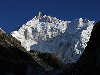
Khangchendzonga National Park also Kanchenjunga Biosphere Reserve is a National Park and a Biosphere reserve located in Sikkim, India. It was inscribed to the UNESCO World Heritage Sites list in July 2016, becoming the first "Mixed Heritage" site of India. It was recently included in the UNESCO Man and the Biosphere Programme. The park gets its name from the mountain Kangchenjunga which is 8,586 metres (28,169 ft) tall, the third-highest peak in the world. The total area of this park is 849.5 km2 (328.0 sq mi).

The Tour du Mont Blanc or TMB is one of the most popular long-distance walks in Europe. It circles the Mont Blanc massif, covering a distance of roughly 170 kilometres (110 mi) with 10 kilometres (6.2 mi) of ascent/descent and passes through parts of Switzerland, Italy and France.

Sandakphu or Sandakfu or Sandakpur is the highest peak in the district of Ilam, Nepal and West Bengal, India. It is the highest point of the Singalila Ridge in Darjeeling district on the West Bengal-Nepal border. The peak is located at the edge of the Singalila National Park and has a small village on the summit with a few hostels. Four of the five highest peaks in the world, Everest, Kangchenjunga, Lhotse and Makalu can be seen from its summit. It also affords a pristine view of the entire Kangchenjunga Range.

Everest base camps refers to two base camps on opposite sides of Mount Everest. South Base Camp is in Nepal at an altitude of 5,364 metres (17,598 ft), while North Base Camp is in Tibet at 5,150 metres (16,900 ft). These camps are rudimentary campsites on Mount Everest that are used by mountain climbers during their ascent and descent. South Base Camp is used when climbing via the southeast ridge, while North Base Camp is used when climbing via the northeast ridge.

Tilicho Lake is a lake located in the Manang district of Nepal, 55 kilometres (34 mi) as the crow flies from the city of Pokhara. It is situated at an altitude of 4,919 metres (16,138 ft) in the Annapurna range of the Himalayas and is sometimes called the highest lake for its size in the world, even though there are lakes at higher altitude even in Nepal, and larger, higher lakes in Tibet.
Another source lists the altitude of Lake Tilicho as being 4,949 metres (16,237 ft).

A long-distance trail is a longer recreational trail mainly through rural areas used for hiking, backpacking, cycling, horse riding or cross-country skiing. They exist on all continents except Antartica.

Nag Tibba, 3,022 metres (9,915 ft), is the highest peak in the lesser himalayan region of Uttarakhand state, and lends its name to the 'Nag Tibba Range', itself the next-northerly of the five folds of the Himalaya. It is situated 16 km (9.9 mi) away from Landour cantonment, and around 57 km from Mussoorie in Tehri Garhwal region of Uttarakhand. The 'Nag Tibba Range' is amongst three principal ranges of the Lesser Himalayas, which includes the Dhauladhar, and the Pir Panjal, which branched off from the Great Himalayas
"The Great Himalaya Trail" was a route across Nepal from east to west; it was renamed Great Himalaya Trails (GHT), adding various trails in the upper and middle districts of Nepal to the original route, opening up new trekking routes and supporting rural development in these areas.
The Annapurna Circuit is a trek within the Annapurna mountain range of central Nepal. The total length of the route varies between 160–230 km (100-145 mi), depending on where motor transportation is used and where the trek is ended. This trek crosses two different river valleys and encircles the Annapurna Massif. The path reaches its highest point at Thorung La pass (5416m/17769 ft), touching the edge of the Tibetan plateau. Practically all trekkers hike the route anticlockwise, as this way the daily altitude gain is slower, and crossing the high Thorong La pass is easier and safer.

Mullayanagiri is the highest peak in Karnataka, India. Mullayyanagiri is located at 13°23′26″N 75°43′18″E in the Chandra Dhrona Hill Ranges of the Western Ghats of Chikkamagaluru Taluk. With a height of 1,930 metres (6,330 ft),It is the fourth highest peak between Nilgiri hills and Himalayas next to Vavulmala, Chembra Peak and Banasura Hill.

Singalila in the Himalaya is a 2016 film directed by George Thengummoottil. It tells the story of a young Keratoconus patient finding his way in life to trek through the Himalayas and finds that, the best medicine for his eyes are the sights of the beautiful mountains and valleys in the Himalayas. The film progress with a 14 day long trek along the border of India and Nepal, known as the Singalila Ridge from where the team enjoys panoramic views of Mount Kangchenjunga and Mount Everest.
Samiti Lake is a alpine glacial lake located in the West Sikkim District of the Sikkim, India. The lake sits at the bottom of Onglakthang Valley, which is located in close proximity to the base of the mountain Pandim and Kangchenjunga and by extension is located in the Himalaya mountain range.

Singling is a community in Sikkim, India. It has been on the trade routes between India and Bhutan since ancient times. A popular tourist activity is to trek between Barsey Rhododendron Sanctuary and Singling. There is an ancient monastery, a lake and amazing mountains. It is known for birding.


