Mount Salak

Last updated
Mount Salak
MT. SALAK - INDONESIA - 2019.jpg
Mount Salak as seen from Caringin District, Bogor Regency
Highest point
Elevation 2,211 m (7,254 ft) [1]
Prominence 1,678 m (5,505 ft) [2]
Listing Ultra
Ribu
Coordinates 06°42′57″S106°44′01″E / 6.71583°S 106.73361°E / -6.71583; 106.73361 [1]
Geography
Java Relief Map.svg
Red triangle with thick white border.svg
Mount Salak
Location on the island of Java
Location Java, Indonesia
Geology
Mountain type Stratovolcano
Last eruption January 1938 [1]

Mount Salak (Indonesian : Gunung Salak, Sundanese : Gunung Salak) is an eroded volcano in West Java, Indonesia. It has several satellite cones on its southeast flank and the northern foot, along with two additional craters at the summit. Mount Salak has been evaluated for geothermal power development. [1] According to a popular belief, the name "Salak" is derived from salak , a tropical fruit with scaly skin; however, according to Sundanese tradition, the name was derived from the Sanskrit word Salaka which means "silver". Mount Salak can be translated to "Silver Mountain" or "Mount Silver".[ citation needed ]

Contents

Geology

Mount Salak is a stratovolcano with its last recorded eruption in January 1938. On October 10, 2018, there was a false alarm, as the VAAC in Darwin said that there was a sudden eruption and that an ash plume from the volcano had risen to 15 km, or 50,000 feet. It was eventually determined that no eruption had taken place. [3]

Hidrology

The complex area of Mount Salak serves as the headwater for two river basins and acts as a boundary between basins that flow towards the northern and southern coasts of Java. The Cisadane River Basin directs its flow towards the northern coast of Java and flows into the Java Sea, while the Cimandiri River Basin directs its flow towards the southern coast of Java and flows into Pelabuhan Ratu bay in the waters of the Indian Ocean. Compared to the Cimandiri River Basin, the Cisadane River Basin encompasses more than 50% of the catchment area on the northern slope, as well as parts of the eastern and western slopes of the Mount Salak complex, located in the Bogor Regency. [4]

Climbing routes

Mount Salak offers several routes for climbing. The route most often climbed is Curug Nangka, in the northern part of the range. Peak I is visited via easier routes from the east, through Cimelati and Cicurug. Peak I also can be reached by more challenging routes, from Peak II via Sukamantri and Ciapus. An additional alternate route is "the back way" through Cidahu, Sukabumi, and Kawah Ratu near Bunder Mount.

Mount Salak is popular for many mountain climbing clubs, especially Route II, because of the difficulty involved in reaching the peak. Climbers bring water with them, especially through Post I at Kawah Ratu Route. A water source, supplied by rain, exists at an altitude of 2,211 m (7,254 ft) on this route.[ clarification needed ]

Cimelati can be reached from Cibuntu Village. Water is scarce in parts of this region. An irrigation system ensures that water is plentiful until Post/Shelter III. Beyond this point, travelers must carry water. The route itself is scenic, with several waterfalls as well as a large villa appearing before reaching Post/Shelter I.

Animals

Crested Serpent Eagle (Spilornis cheela) at Eagle Sanctuary, Loji, Cigombong, West Java, on the slope of Mount Salak, ready to be released. Elang-Ular Bido.jpg
Crested Serpent Eagle ( Spilornis cheela ) at Eagle Sanctuary, Loji, Cigombong, West Java, on the slope of Mount Salak, ready to be released.

Mount Salak is a habitat for a variety of animal species, including frogs, toads, reptiles, birds, and mammals. During research, D. M. Nasir (2003)[ full citation needed ] from KSH forest faculty IPB found 11 frog and toad species in Lingkungan S (Environment S) at Ciapus Leutik, Desa Taman Sari, Bogor Residency. They are the Asian giant toad , the Asian common toad , the Java spadefoot toad , the Indian cricket frog , Huia masonii , Limnonectes kuhlii , Limnonectes macrodon , Limnonectes microdiscus , Rana chalconota , Rana erythraea , and Rana hosii . The findings did not include tree toads and other mountain toads that might also be found there. At Cidahu, bangkong bertanduk ( Megophrys montana ) and katak terbang ( Rhacophorus reinwardtii ) were found.

Many reptiles, including lizards and snakes, live on Mount Salak. These include the chameleons Bronchocela jubata , Bronchocela cristatella , Kadal Kebun ( Mabuya multifasciata ), and Biawak Sungai ( Varanus salvator ). Some snakes living in Mount Salak are Ular Tangkai ( Calamaria sp.), Ular Siput ( Pareas carinatus ), Ular Sanca Kembang ( Python reticulatus ), and many more. Mount Salak has become famous for its habitat for birds; there are at least 232 birds species in total. [5] The most notable birds are Elang Jawa ( Spizaetus bartelsi ), Crested Serpent Eagle ( Spilornis cheela ), Ayam Hutan Merah ( Gallus gallus ), Cuculus micropterus , Phaenicophaeus javanicus , Phaenicophaeus curvirostris , Sasia abnormis , Dicrurus remifer , Cissa thalassina , Crypsirina temia , Burung Kuda ( Garrulax rufifrons ), Hypothymis azurea , Aethopyga eximia , Aethopyga mystacalis , and Lophozosterops javanicus . The notes about mammals indicate that there are not many living on Mount Salak, aside from leopards, silvery gibbons, Javan surilis, and sunda pangolins.

Aircraft accidents

In 2012, The Jakarta Post dubbed Mount Salak an "airplane graveyard". [6] High turbulence and fast-changing weather conditions of the mountainous terrain are cited as contributing factors to multiple aviation crashes in the area. [6] There were seven aviation crashes around Mount Salak between 2002 and 2012.

One person was killed in the crash of a small aircraft in October 2002, seven in October 2003, two in April 2004, and five in June 2004. Eighteen people were killed in a crash of an Indonesian Air Force military plane in 2008. [6] [7]

In 2012, three people were killed in a crash of a training aircraft not long before the SSJ-100 crash, which occurred on May 9, 2012: a Sukhoi Superjet 100 crashed into the mountain during a demonstration flight, killing all 45 people on board. [8]

See also

Commons-logo.svg Media related to Mount Salak at Wikimedia Commons

Related Research Articles

<span class="mw-page-title-main">Mount Tambora</span> Active stratovolcano in Indonesia

Mount Tambora, or Tomboro, is an active stratovolcano in West Nusa Tenggara, Indonesia. Located on Sumbawa in the Lesser Sunda Islands, it was formed by the active subduction zones beneath it. Before 1815, its elevation reached more than 4,300 metres high, making it one of the tallest peaks in the Indonesian archipelago.

<span class="mw-page-title-main">Volcanism of Java</span> Volcanic activity on the Indonesian island of Java

The Indonesian island of Java is almost entirely of volcanic origin, and contains numerous volcanoes, 45 of which are considered active volcanoes. As is the case for many other Indonesian islands, volcanoes have played a vital role in the geological and human history of Java. Indeed, land is created on Java as a result of lava flows, ash deposits, and mud flows (lahars). Volcanoes are a major contributor to the immense fertility of Java, as natural erosion transports volcanic material as alluvium to the island's plains, forming thick layers of fertile sediment. The benefit is not just in the immediate vicinity of the volcano, with fine ash emitted from eruptions being dispersed over wide areas.

<span class="mw-page-title-main">Mount Merapi</span> Active stratovolcano in Central Java, Indonesia

Mount Merapi,, is an active stratovolcano located on the border between the province of Central Java and the Special Region of Yogyakarta, Indonesia. It is the most active volcano in Indonesia and has erupted regularly since 1548. It is located approximately 28 km (17 mi) north of Yogyakarta city which has a population of 2.4 million, and thousands of people live on the flanks of the volcano, with villages as high as 1,700 m (5,577 ft) above sea level.

<span class="mw-page-title-main">Kelud</span> Stratovolcano in East Java, Indonesia.

The Kelud is an mountain stratovolcano located in Kediri, East Java, Indonesia. Like many Indonesian volcanoes and others on the Pacific Ring of Fire, Kelud is known for large explosive eruptions throughout its history. More than 30 eruptions have occurred since 1000 AD. In 2007, an effusive explosion filled the crater with a lava dome. It last erupted on 13 February 2014, destroying the lava dome and ejecting boulders, stones and ashes up to West Java about 500 kilometres (310 mi) from Mount Kelud. The crater filled with water during the rainy season.

<span class="mw-page-title-main">Ciliwung</span> River in Java, Indonesia

Ci Liwung is a 119 km long river in the northwestern region of Java where it flows through two provinces, West Java and the special region of Jakarta. The natural estuary of the Ciliwung river, known as the Kali Besar, was an important strategic point for trade in the precolonial and colonial periods and was instrumental in the founding of the port city of Jakarta, but has been lost from reorganization of the watercourse of the rivers around the area into canals.

<span class="mw-page-title-main">Mount Merbabu</span> Stratovolcano in Central Java, Indonesia

Mount Merbabu is a dormant stratovolcano in Central Java province on the Indonesian island of Java. The name Merbabu could be loosely translated as 'Mountain of Ash' from the Javanese combined words; Meru means "mountain" and awu or abu means "ash".

<span class="mw-page-title-main">Mount Gede</span> Stratovolcano in West Java, Indonesia

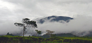
Mount Gede or Gunung Gede is a stratovolcano in West Java, Indonesia. The volcano contains two peaks with Mount Gede as one peak and Mount Pangrango for the other one. Three major cities, Cianjur, Sukabumi and Bogor, are located in the volcano complex at the east, south and northwest, respectively, along with suburban growth. Seven craters are located in the complex: Baru, Gumuruh (2,927 m), Lanang (2,800 m), Kawah Leutik, Ratu (2,800 m), Sela (2,709 m) and Wadon (2,600 m). Historical volcanic activity has been recorded since the 16th century. With the amalgamation and growth of Greater Jakarta with those 3 cities, dense suburban growth has engulfed the fringes of the volcano, home to roughly 4 million people. Though not listed as one of the Decade Volcanoes or thought to produce large eruptions, the huge populations nearby give a potential for severe destruction if indeed a large eruption did occur.

<span class="mw-page-title-main">Mount Papandayan</span> Complex stratovolcano in Java, Indonesia

Mount Papandayan is a complex stratovolcano, located in Garut Regency, to the southeast of the city of Bandung in West Java, Indonesia. It is about 15 kilometres (9.3 mi) to the southwest of the town of Garut. At the summit, there are four large craters which contain active fumarole fields. An eruption in 1772 caused the northeast flank to collapse producing a catastrophic debris avalanche that destroyed 40 villages and killed nearly 3,000 people. The eruption truncated the volcano into a broad shape with two peaks and a flat area 1.1 km wide with Alun-Alun crater in the middle, making the mountain appear as a twin volcano; one of the peaks is called Papandayan and the other Mount Puntang.

<span class="mw-page-title-main">Mount Gede Pangrango National Park</span> National park on Java island, Indonesia

Mount Gede Pangrango National Park is a national park in West Java, Indonesia. The park is centred on two volcanoes—Mount Gede and Mount Pangrango—and is 150 km² in area.

<span class="mw-page-title-main">Mount Pangrango</span> Volcano in West Java, Indonesia

Mount Pangrango is a dormant stratovolcano located in the Sunda Arc of West Java, Indonesia. The mountain formed by a subduction zone on the southern coast of Java as part of the Sunda Plate facing the Australian Plate which contains Indian Ocean. It is located about 80 kilometres (50 mi) south of Jakarta, the capital of Indonesia.

<span class="mw-page-title-main">Mandiri River</span> River in Indonesia

Mandiri River is a river in southwestern Java of West Java province, Indonesia. It flows mainly in the Sukabumi Regency.

<span class="mw-page-title-main">Kawah Putih</span> Crater lake in Indonesia

Kawah Putih is a crater lake and tourist spot in a volcanic crater about 50 kilometres (31 mi) south of Bandung in West Java in Indonesia.

<span class="mw-page-title-main">Lake Bandung</span> Former lake

Lake Bandung was a prehistoric lake located in and around the city of Bandung, Parahyangan highlands, West Java, Indonesia. believed to exist between 126,000 and 20,000 BCE in the Pleitocene due to the violent eruption of Mount Sunda that blocked the Citarum River, causing the lowlands to begin to be inundated with water, eventually forming a lake.

Mount Sunda, was an ancient volcano that once stood in Priangan highlands in today's West Java province, Java island, Indonesia. The Sunda volcano existed during Pleistocene age, before a violent Plinian eruption caused its summit to collapse. The volcano formed the northern ridge of the Bandung Basin. The ancient volcano is the predecessor of today's Tangkuban Perahu, Burangrang, and Bukit Tunggul volcanoes.

<span class="mw-page-title-main">Mount Halimun</span> Mountain in Indonesia

Mount Halimun is a mountain in the island of Java, Indonesia. It is protected by the Mount Halimun Salak National Park. It is Banten's highest point.

<span class="mw-page-title-main">Blue lava</span> Optical phenomenon resulting from burning sulfur

Blue lava, also known as Api Biru, and simply referred to as blue fire or sulfur fire, is a phenomenon that occurs when sulfur burns. It is an electric-blue flame that has the illusory appearance of lava. Despite the name, the phenomenon is actually a sulfuric fire that resembles the appearance of lava, rather than actual lava from a volcanic eruption. The most well-documented of these fires occur on Indonesia's Kawah Ijen volcano, where they regularly burn.

<span class="mw-page-title-main">Cianten River</span> River in West Java, Indonesia

The Cianten is a river which flows in the western part of Bogor Regency, West Java, and is a tributary of the Cisadane River.

References

  1. 1 2 3 4 "Salak". Global Volcanism Program . Smithsonian Institution . Retrieved 2021-06-24.
  2. "Mountains of the Indonesian Archipelago". Peaklist.org. Retrieved 2013-08-18.
  3. "Salak volcano news & activity updates". Volcano Discovery . Retrieved 29 October 2018.
  4. "Peta Interaktif". WebGIS MenLHK (in Indonesian).
  5. Vorderman (1885)[ full citation needed ] and Hoogerwerf (1948).[ full citation needed ]
  6. 1 2 3 "Mt. Salak: An airplane graveyard". The Jakarta Post . 10 May 2012. Archived from the original on 12 May 2012. Retrieved 11 May 2012.
  7. В районе индонезийской горы Салак за последние 10 лет произошло уже 7 авиакатастроф
  8. Vaswani, Karishma (10 May 2012). "Rescue workers find bodies at Russia jet crash site". BBC News . Retrieved 11 May 2012.