The Court of the Patriarchs' is a sandstone cliff on the south face of the Three Patriarchs in Zion Canyon in Zion National Park in Washington County, Utah, United States.

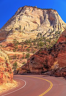
The East Temple is a prominent 7,709 feet (2,350 m) summit composed of Navajo Sandstone in Zion National Park, in Washington County of southwest Utah, United States. It is one of the notable landmarks in the park. The nearest neighbor is Twin Brothers, one-half mile to the north, and the nearest higher peak is The West Temple, 3.85 miles (6.20 km) to the west-southwest. The mountain is situated 1.8 miles northeast of the park headquarters, at the confluence of Pine Creek and the North Fork Virgin River. This feature's name was applied by John Wesley Powell during his explorations in 1872, and was officially adopted in 1934 by the U.S. Board on Geographic Names. The first ascent was made in 1937 by Glen Dawson, Dick Jones, Homer Fuller, Wayland Gilbert, and Jo Momyer.

The West Temple is a prominent 7,810-foot mountain summit composed of Navajo Sandstone in Zion National Park in Washington County of Utah, United States. This, the highest feature in Zion Canyon, was originally called "Temp-o-i-tin-car-ur" meaning "Mountain without a trail" by the Paiute people. It was called Steamboat Mountain by local Mormon settlers before 1934, when the USGS officially changed it to its present name, which was applied by John Wesley Powell during his explorations in 1872. West Temple is situated two miles northwest of Springdale, Utah, one mile northeast of Mount Kinesava, and two miles west of the park headquarters. It is one of the notable landmarks in the park. The nearest higher peak is Windy Peak, 10.46 miles (16.83 km) to the north. Precipitation runoff from the mountain drains into tributaries of the Virgin River.

The Watchman is a 6,545-foot (1,995 m) sandstone mountain summit located in Zion National Park, in Washington County of southwest Utah, United States.

Mount Kinesava is a 7,285-foot (2,220 m) sandstone mountain summit located in Zion National Park, in Washington County of southwest Utah, United States.

Mount Moroni is a 5,690-foot (1,730 m) elevation Navajo Sandstone summit located at the Court of the Patriarchs in Zion National Park, in Washington County of southwest Utah, United States.

The Sentinel is a 7,120+ ft elevation Navajo Sandstone summit located near the Court of the Patriarchs in Zion National Park, in Washington County of southwest Utah, United States, that is part of the Towers of the Virgin. The national park map lists the elevation as 7,157-feet.

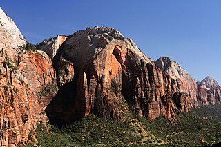
The Organ is a 5,080-foot (1,550 m) elevation Navajo Sandstone summit located in Zion National Park, in Washington County of southwest Utah, United States. The Organ is situated in the Big Bend at the north end of Zion Canyon, rising 700-feet above the canyon floor and the North Fork of the Virgin River which drains precipitation runoff from this rock. Neighbors include The Great White Throne, Cathedral Mountain, Angels Landing, Observation Point, and Cable Mountain. The Organ is believed to have been named by Claud Hirschi and Ethelbert Bingham, residents of Rockville, on their 1916 trip with Methodist Minister Frederick Vining Fisher, who also named geographical formations in Zion. This geographical feature's descriptive name was officially adopted in 1934 by the U.S. Board on Geographic Names.

Altar of Sacrifice is a 7,505-foot (2,288 m) Navajo Sandstone mountain in Zion National Park in Washington County, Utah, United States, that is part of the Towers of the Virgin.

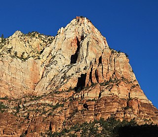
Mountain of the Sun is a 6,722-foot (2,049 m) elevation Navajo Sandstone summit located in Zion National Park, in Washington County of southwest Utah, United States. Mountain of the Sun is situated immediately east of Court of the Patriarchs, and south of Zion Lodge, towering 2,500-feet above the lodge and the floor of Zion Canyon. It is set on the east side of the North Fork of the Virgin River which drains precipitation runoff from this mountain. Its neighbors include The Sentinel, Mount Spry, The East Temple, and Mount Moroni. This feature's name was officially adopted in 1934 by the U.S. Board on Geographic Names.
Lady Mountain is a 6,945-foot (2,117 m) elevation Navajo Sandstone summit located in Zion National Park, in Washington County of southwest Utah, United States.
Red Arch Mountain is a 5,930-foot (1,810 m) elevation Navajo Sandstone summit located in Zion National Park, in Washington County of southwest Utah, United States.

Twin Brothers is a 6,863-foot (2,092 m) Navajo Sandstone mountain in Zion National Park in Washington County, Utah, United States.

Ivins Mountain is a remote 7,019-foot (2,139 m) Navajo Sandstone summit located in Zion National Park, in Washington County of southwest Utah, United States.

The Sundial is a 7,590-foot elevation white Navajo Sandstone summit located in Zion National Park, in Washington County of southwest Utah, United States.

The Witch Head is a 7,340-foot (2,240 m) white Navajo Sandstone mountain in Zion National Park in Washington County, Utah, United States, that is part of the Towers of the Virgin.

Ant Hill is a 6,641-foot (2,024 m) summit located in Zion National Park, in Washington County of southwest Utah, United States. It is composed of white Navajo Sandstone, and rises 1400-feet above the Zion – Mount Carmel Highway. Ant Hill is situated 1.65 mi (2.66 km) east-northeast of The East Temple, and 2.4 mi (3.9 km) west-northwest of Checkerboard Mesa. Precipitation runoff from this mountain drains into tributaries of the Virgin River. Despite its benign name, an ascent of this mountain is a dangerous and exposed climb.

Deertrap Mountain is a 6,837-foot (2,084 m) mountain in Zion National Park in Washington County, Utah, United States.
Crazy Quilt Mesa is a 6,760 ft (2,060 m) elevation white Navajo Sandstone summit located in Zion National Park, in Kane County of southwest Utah, United States.

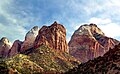
The Three Patriarchs is a set of three sandstone monoliths on the west side of Zion Canyon in Zion National Park in Washington County, Utah, United States. The three main peaks were named by Frederick Fisher in 1916 for the biblical figures Abraham, Isaac and Jacob. The Court of the Patriarchs is the cliff that runs along the south face of the Three Partiarchs.