Mount Vernon, Washington

Last updated

Mount Vernon
Mount Vernon WA 04.jpg
First Street
Flag of Mount Vernon, Washington.svg
Nickname: 
City of Tulips
Skagit County Washington Incorporated and Unincorporated areas Mount Vernon Highlighted.svg
Location of Mount Vernon in Washington State
Usa edcp location map.svg
Red pog.svg
Mount Vernon
Location of Mount Vernon in the United States
Coordinates: 48°25′12″N122°19′34″W / 48.42000°N 122.32611°W / 48.42000; -122.32611
CountryUnited States
State Washington
County Skagit
Incorporated July 5, 1889
Named for Mount Vernon
Government
  Type Mayor–council
  MayorPeter Donovan
Area
[1]
   City 12.62 sq mi (32.70 km2)
  Land12.30 sq mi (31.85 km2)
  Water0.33 sq mi (0.84 km2)  2.46%
Elevation
180 ft (54.9 m)
Population
 (2020) [2]
   City 35,219
  Estimate 
(2021) [3]
35,404
  Density2,863.33/sq mi (1,105.78/km2)
   Urban
62,966 (US: 435th)
   Metro
130,696 (US: 313th)
Time zone UTC-8 (PST)
  Summer (DST) UTC-7 (PDT)
ZIP codes
98273, 98274
Area code 360, 564
FIPS code 53-47560
GNIS feature ID1512485 [4]
Website mountvernonwa.gov

Mount Vernon is the county seat of Skagit County, Washington, United States. The population was 35,219 at the 2020 census. [2] It is one of two principal cities of and included in the Mount Vernon-Anacortes, Washington Metropolitan Statistical Area. Downtown Mount Vernon is known for its annual Tulip Festival Street Fair, which is part of the Skagit Valley Tulip Festival. The climate of Skagit County is similar to that of Northern France, with millions of tulips grown in the Skagit Valley. In 1998, Mount Vernon was rated the #1 "Best City in America" by the New Rating Guide to Life in America's Small Cities. [5] [6]

Contents

History

Early days

Mount Vernon in 1880 Mount Vernon, Washington, in 1880.png
Mount Vernon in 1880

Jasper Gates and Joseph Dwelley first settled on the banks of the Skagit River, where the city of Mount Vernon now lies, in 1870. Later on, Harrison Clothier came to the community in 1877 to teach school and join in business with a former student, E.G. English. They were later recognized as the city's founders and pioneer businessmen. A post office was established in November 1877 with Clothier appointed postmaster. The city was named after Mount Vernon, the plantation estate and resting place of George Washington. [7] The two men laid out the city's first plan while the area was still heavily timbered. [8]

Mount Vernon's first industry was logging; camps were set up to log the townsite. The community grew quickly following the loggers, and hotels and saloons opened up along the Skagit River next to English & Clothiers' store. While poised to grow, river access to the community was stymied by a massive and ancient log jam in the river which prevented large ships from being able to port. Mail carriers instead had to paddle canoes down-stream to nearby Skagit City which enjoyed a brief period of prosperity thanks to this obstacle. The mining activity at nearby Ruby Creek spurred growth for a short time in 1880, gaining the city a new hotel, but little else was accomplished when the mines proved to be shallow. More logging operations were established but were not profitable due to the low price of logs at the time. By 1881, Mount Vernon's permanent population was a modest 75. [8]

Growth in the 1880s was steady. In 1882, the Odd Fellows Lodge was established, followed by the first newspaper in 1884, The Skagit News. The first church, Baptist, was also established in 1884 but would not build a permanent building for several years. In November 1884, Mount Vernon's future was secured when it was chosen for the new Skagit County seat, taking the designation from La Conner. The Odd fellows building, built the following year, served the county's needs until a permanent building was built. [8]

Railroad and growth into the 20th century

Mount Vernon's growth was helped by its central location in reference to the mining, logging and farming communities of the eastern and central parts of the county as well as its access to Puget Sound. The only thing it was lacking was a railroad connection to the outside world, especially, Everett, Seattle and Vancouver, B.C. A committee was appointed in 1889 to negotiate with railroads on line placement. Their efforts paid off when the Great Northern Railway agreed to lay their line through the city. This was completed in 1891. The city was also in the process of convincing the Seattle, Lake Shore and Eastern Railway to come to Mt. Vernon. This deal fell through after the railroad was acquired by Northern Pacific Railway who chose to lay tracks further east through Sedro-Woolley in 1896. [8]

The railroad's arrival caused great commotion in Mount Vernon, bringing hundreds of new businesses and residents. Mount Vernon was officially incorporated on July 5, 1893. That same year, a large brick courthouse was built on Main street, which still stands today. Due to the area's stable economy, Mount Vernon never boomed in the 1890s like many other speculative settlements in the region, all vying for a railroad terminus. The city experienced its first of many fires in 1891 when several blocks along the waterfront were destroyed. The same year the city's riverfront eroded taking away Front Street and the west side of Main Street. [9] The boost from the railroad's construction quickly replaced these buildings. 1891 also saw the construction of several large civic structures such as a large brick schoolhouse on the hill above the city as well as the Mount Vernon Opera House, designed by Peacock & Dalton.

Growth slowed considerably after the Panic of 1893. Following a large flood in 1894, the first dike was built along the Skagit River. Another great fire in 1900 wiped out all of Mount Vernon's original structures including English & Clothiers' store and the Ruby Hotel. Fire would destroy more downtown businesses in 1903. The city finally received a water system in 1902 after a failed attempt in 1894. [8]

Later events and transportation

The city again grew in the 1910s when it became the southern terminus for the Bellingham & Skagit Railway's interurban railroad line, which would carry passengers as well as freight between Bellingham and Mount Vernon as well as Burlington and Sedro-Woolley. The line opened on August 31, 1912, with passenger trips to Bellingham every two hours during the day and freight operating at night. Mount Vernon business owners soon began pressuring the railway company, since renamed the Pacific Northwest Traction Company, to extend the rails south to connect with the interurban line in Everett. Plagued by a weakening economy, the onset of America's entrance into World War I in 1917, and numerous infrastructure failures that led to line closures for months at a time, extension of the interurban was put off indefinitely. The completion of the Pacific Highway between Seattle and Bellingham in 1920 posed a great threat to the still incomplete interurban line. After a series of accidents and bridge wash outs, passenger service on the money-losing line was permanently suspended in June 1930. [10] In 1969, Interstate 5 was built through downtown, severing it from most of the residential district and opening the farm lands north of the city to urban development, where many of Mount Vernon's downtown businesses moved.

Culture

Lincoln Theatre Mount Vernon WA 03.jpg
Lincoln Theatre

The Historic Lincoln Theatre on First Street in downtown Mount Vernon was originally built in 1926 as a vaudeville and silent movie house. Through the early 1980s, the Lincoln was a movie theater showing first-run films and now hosts live theatrical performances and concerts while also showcasing classic, as well as contemporary, movies year-round. The Lincoln is one of only 98 theaters in the United States that still possesses its original Wurlitzer theatre organ, which is often played prior to a show. [11]

In addition, the Skagit Symphony resides in the area. [12]

Geography

According to the United States Census Bureau, the city has a total area of 12.61 square miles (32.66 km2), of which, 12.30 square miles (31.86 km2) is land and 0.31 square miles (0.80 km2) is water. [13]

Climate

Like much of the Pacific Northwest, according to the Köppen climate classification, Mount Vernon falls within a cool dry-summer subtropical zone (Csb), with "cool"-summer Mediterranean characteristics. Other sources classify it as belonging in the marine west coast climate (Köppen Cfb) zone, with cool, wet winters and warm, distinctly drier summers.

Climate data for Mount Vernon (1971–2000)
MonthJanFebMarAprMayJunJulAugSepOctNovDecYear
Mean daily maximum °F (°C)45.7
(7.6)
49.5
(9.7)
53.4
(11.9)
58.1
(14.5)
64.0
(17.8)
68.4
(20.2)
73.0
(22.8)
74.1
(23.4)
69.1
(20.6)
60.0
(15.6)
50.9
(10.5)
46.0
(7.8)
59.4
(15.2)
Daily mean °F (°C)39.9
(4.4)
42.7
(5.9)
45.7
(7.6)
49.3
(9.6)
54.7
(12.6)
58.9
(14.9)
62.3
(16.8)
62.9
(17.2)
58.3
(14.6)
50.9
(10.5)
44.5
(6.9)
40.3
(4.6)
50.9
(10.5)
Mean daily minimum °F (°C)34.1
(1.2)
35.9
(2.2)
37.9
(3.3)
40.5
(4.7)
45.4
(7.4)
49.4
(9.7)
51.5
(10.8)
51.6
(10.9)
47.5
(8.6)
41.8
(5.4)
38.1
(3.4)
34.6
(1.4)
42.4
(5.8)
Average precipitation inches (mm)4.22
(107)
2.85
(72)
2.81
(71)
2.53
(64)
2.42
(61)
1.95
(50)
1.20
(30)
1.34
(34)
1.70
(43)
2.89
(73)
4.83
(123)
3.96
(101)
32.7
(829)
Source: NOAA (normals, 1971–2000) [14]

Flood control and waterfront redevelopment

The Skagit River, which flows through Mount Vernon, is prone to flooding during periods of heavy rain in the Cascades. In October 2003 the townspeople of Mount Vernon turned out to build a sandbag dike along the river in anticipation of a flood. Skagit River sandbagging 2003.jpg
The Skagit River, which flows through Mount Vernon, is prone to flooding during periods of heavy rain in the Cascades. In October 2003 the townspeople of Mount Vernon turned out to build a sandbag dike along the river in anticipation of a flood.

Since this city was founded, the downtown area of Mount Vernon bordering the Skagit River has been plagued by flooding, especially during times of heavy rain. Each time the water rises above a certain level, citizens historically had to join to build a sandbag wall that stretches six city blocks and can be as high as 5 feet (1.5 m). In the spring of 2007, the city council authorized the mayor to purchase a mobile flood wall from Norway-based company AquaFence, the first such flood wall sold in the United States. [15] The flood wall is 4 feet (1.2 m) high and can be assembled in as little as three hours by a handful of volunteers as opposed to the up to 12 hours and hundreds of volunteers required by the traditional sandbag wall. The flood wall was completed in 2019. [16]

After adequate flood control is in place, a Citizens' Advisory Committee plans to enhance the city's use of the revetment, which is currently used mostly for parking and a seasonal farmer's market. [17] Current plans call for a promenade with condos or mixed-use development facing the river. A two- or three-story parking garage is planned to replace the revetment parking lost due to development. [18] During Thanksgiving 2017 the city, as well as Lyman and Hamilton, experienced flooding; [19] and again on November 15, 2021. [20]

Transportation

Mount Vernon's main transportation hub is Skagit Station, built in 2004, which is served by Amtrak and bus operators. [21] Commuters and travelers can switch between modes of transportation in downtown Mount Vernon. The station offers stops for Skagit Transit buses, [22] Greyhound bus, Amtrak Cascades rail and local taxi. The 90x Skagit Snohomish Connector bus route connects to the Sounder Train in Everett. [23]

Skagit Regional Airport, 5 mi (8.0 km) northwest, fills much of the area's general aviation needs. It has service on two cargo airlines. The closest commercial airport with scheduled passenger service is Bellingham International Airport, 25 miles (40 km) north.

Major highways

Government and politics

The City of Mount Vernon is a code city and uses a Mayor-Council form of government. The Mayor is the chief executive and administrative officer for the City of Mount Vernon and oversees and manages all operations including: Finance, City Attorney, Information Services, Human Resources, Development Services, Library, Public Works, Parks and Enrichment Services, Police, and Fire Department. This includes a City staff of 235 full time employees, 56 part time/seasonal employees, and a total City budget of $70 million. [24] The directly elected mayor serves a four-year term, with the next election being set to occur on November 4, 2025. Six of the seven city council members are elected by the three wards of Mount Vernon for staggered four-year terms. The seventh council member is elected at-large every two years. [25] Incumbent Mayor of Mount Vernon Peter Donovan started his first term on December 23, 2023, succeeding three-term mayor Jill Boudreau. [24]

Mount Vernon is represented by Representative Rick Larsen (D) in the U.S. House of Representatives representing the state's 2nd district, and represented in Olympia by the 40th, 39th, and 10th districts.

Demographics

Historical population
CensusPop.Note
1890 770
1900 1,12045.5%
1910 2,381112.6%
1920 3,34140.3%
1930 3,69010.4%
1940 4,27815.9%
1950 5,23022.3%
1960 7,92151.5%
1970 8,80411.1%
1980 13,00947.8%
1990 17,64735.7%
2000 26,23248.6%
2010 31,74321.0%
2020 35,21911.0%
2021 (est.)35,404 [3] 0.5%
U.S. Decennial Census [26]
2020 Census [2]

The median income for a household in the city was $53,496. [27] Males had a median income of $33,724 versus $27,244 for females. The per capita income for the city was $17,041. About 10.8% of families and 15.9% of the population were below the poverty line, including 18.9% of those under age 18 and 7.1% of those age 65 or over.

2010 census

As of the census [28] of 2010, there were 31,743 people, 11,342 households, and 7,443 families residing in the city. The population density was 2,580.7 inhabitants per square mile (996.4/km2). There were 12,058 housing units at an average density of 980.3 per square mile (378.5/km2). The racial makeup of the city was 72.8% White, 1.0% African American, 1.6% Native American, 2.7% Asian, 0.2% Pacific Islander, 17.6% from other races, and 4.0% from two or more races. Hispanic or Latino of any race were 33.7% of the population.

There were 11,342 households, of which 37.1% had children under the age of 18 living with them, 47.6% were married couples living together, 12.2% had a female householder with no husband present, 5.8% had a male householder with no wife present, and 34.4% were non-families. 26.8% of all households were made up of individuals, and 12% had someone living alone who was 65 years of age or older. The average household size was 2.74 and the average family size was 3.33.

The median age in the city was 32.3 years. 28.2% of residents were under the age of 18; 10.1% were between the ages of 18 and 24; 27.5% were from 25 to 44; 21.4% were from 45 to 64; and 12.7% were 65 years of age or older. The gender makeup of the city was 49.0% male and 51.0% female.

2000 census

As of the census of 2000, there were 26,232 people, 9,276 households, and 6,205 families residing in the city. The population density was 2,360.6 people per square mile (911.6/km2). There were 9,686 housing units at an average density of 871.6 per square mile (336.6/km2). The racial makeup of the city was 75.44% White, 0.73% African American, 1.02% Native American, 2.58% Asian, 0.15% Pacific Islander, 17.13% from other races, and 2.95% from two or more races. Hispanic or Latino of any race were 25.12% of the population.

There were 9,276 households, out of which 36.5% had children under the age of 18 living with them, 51.3% were married couples living together, 11.4% had a female householder with no husband present, and 33.1% were non-families. 26.1% of all households were made up of individuals, and 10.9% had someone living alone who was 65 years of age or older. The average household size was 2.75 and the average family size was 3.32.

In the city, the age distribution of the population shows 29.0% under the age of 18, 11.9% from 18 to 24, 29.0% from 25 to 44, 17.6% from 45 to 64, and 12.5% who were 65 years of age or older. The median age was 31 years. For every 100 females, there were 96.2 males. For every 100 females age 18 and over, there were 92.9 males.

Notable people

Sister cities

Mount Vernon has the following Sister Cities, according to the Washington State Lt. Governor's office: [30]

See also

Related Research Articles

<span class="mw-page-title-main">Whatcom County, Washington</span> County in Washington, United States

Whatcom County is a county located in the northwestern corner of the U.S. state of Washington, bordered by the Lower Mainland of British Columbia to the north, Okanogan County to the east, Skagit County to the south, San Juan County across Rosario Strait to the southwest, and the Strait of Georgia to the west. Its county seat and largest population center is the coastal city of Bellingham, comprising the Bellingham, WA Metropolitan Statistical Area, and as of the 2020 census, the county's population was 226,847.

<span class="mw-page-title-main">Snohomish County, Washington</span> County in Washington, United States

Snohomish County is a county located in the U.S. state of Washington. With a population of 827,957 as of the 2020 census, it is the third-most populous county in Washington, after nearby King and Pierce counties, and the 73rd-most populous in the United States. The county seat and largest city is Everett. The county forms part of the Seattle metropolitan area, which also includes King and Pierce counties to the south.

<span class="mw-page-title-main">Skagit County, Washington</span> County in Washington, United States

Skagit County is a county in the U.S. state of Washington. As of the 2020 census, the population was 129,523. The county seat and largest city is Mount Vernon. The county was formed in 1883 from Whatcom County and is named for the Skagit Indian tribe, which has been indigenous to the area prior to European-American settlement.

<span class="mw-page-title-main">Mount Vernon, Iowa</span> City in Iowa, United States

Mount Vernon is a city in Linn County, Iowa, United States, adjacent to the city of Lisbon. The population was 4,527 at the time of the 2020 census. Mount Vernon is part of the Cedar Rapids Metropolitan Statistical Area.

<span class="mw-page-title-main">Alger, Washington</span> CDP in Washington, United States

Alger is a census-designated place (CDP) in Skagit County, Washington, United States. The population was 403 at the 2010 census. It is included in the Mount Vernon–Anacortes, Washington Metropolitan Statistical Area.

<span class="mw-page-title-main">Anacortes, Washington</span> City in Washington, United States

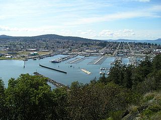
Anacortes is a city in Skagit County, Washington, United States. The name "Anacortes" is an adaptation of the name of Anne Curtis Bowman, who was the wife of early Fidalgo Island settler Amos Bowman. Anacortes' population was 17,637 at the time of the 2020 census. It is one of two principal cities of and included in the Mount Vernon-Anacortes Metropolitan Statistical Area.

<span class="mw-page-title-main">Burlington, Washington</span> City in Washington, United States

Burlington is a city in Skagit County, Washington, United States. Its population was recorded as 9,152 in the 2020 census. Burlington is located approximately halfway between Seattle and Vancouver, B.C. The city is included in the Mount Vernon–Anacortes, Washington Metropolitan Statistical Area.

<span class="mw-page-title-main">Concrete, Washington</span> Town in Washington, United States

Concrete is a town in north-central Skagit County, Washington, United States. It is part of the Mount Vernon-Anacortes, Washington Metropolitan Statistical Area, and had a population of 705 at the 2010 census.

<span class="mw-page-title-main">La Conner, Washington</span> Town in Washington, United States

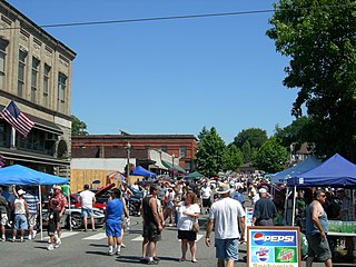
La Conner is a town in Skagit County, Washington, United States with a population of 965 at the 2020 census. It is included in the Mount Vernon–Anacortes, Washington Metropolitan Statistical Area. The town hosts several events as part of the annual Skagit Valley Tulip Festival held in April.

<span class="mw-page-title-main">Sedro-Woolley, Washington</span> City in Washington, United States

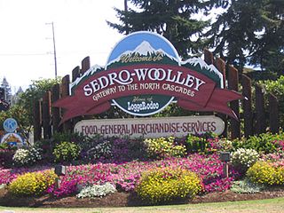
Sedro-Woolley is a city in Skagit County, Washington, United States. It is a suburb of Mount Vernon, the county seat, and part of the Mount Vernon–Anacortes, Washington Metropolitan Statistical Area and had a population of 12,421 at the 2020 census. The city is home to North Cascades National Park.

<span class="mw-page-title-main">Arlington, Washington</span> City in Washington, United States

Arlington is a city in northern Snohomish County, Washington, United States, part of the Seattle metropolitan area. The city lies on the Stillaguamish River in the western foothills of the Cascade Range, adjacent to the city of Marysville. It is approximately 10 miles (16 km) north of Everett, the county seat, and 40 miles (64 km) north of Seattle, the state's largest city. As of the 2020 U.S. census, Arlington had a population of 19,868; its estimated population is 20,075 as of 2021.

<span class="mw-page-title-main">Granite Falls, Washington</span> City in Washington, United States

Granite Falls is a city in Snohomish County, Washington, United States. It is located between the Pilchuck and Stillaguamish rivers in the western foothills of the Cascade Range, northeast of Lake Stevens and Marysville. The city is named for a waterfall north of downtown on the Stillaguamish River, also accessible via the Mountain Loop Highway. It had a population of 3,364 at the 2010 census.

<span class="mw-page-title-main">Lynnwood, Washington</span> City in Washington, United States

Lynnwood is a city in Snohomish County, Washington, United States. The city is part of the Seattle metropolitan area and is located 16 miles (26 km) north of Seattle and 13 miles (21 km) south of Everett, near the junction of Interstate 5 and Interstate 405. It is the fourth-largest city in Snohomish County, with a population of 38,568 in the 2020 U.S. census.

<span class="mw-page-title-main">Snohomish, Washington</span> City in Washington, United States

Snohomish is a city in Snohomish County, Washington, United States. The population was 9,098 at the 2010 census. It is located on the Snohomish River, southeast of Everett and northwest of Monroe. Snohomish lies at the intersection of U.S. Route 2 and State Route 9. The city's airport, Harvey Airfield, is located south of downtown and used primarily for general aviation.

<span class="mw-page-title-main">Stanwood, Washington</span> City in Washington, United States

Stanwood is a city in Snohomish County, Washington, United States. The city is located 50 miles (80 km) north of Seattle, at the mouth of the Stillaguamish River near Camano Island. As of the 2010 census, its population is 6,231.

<span class="mw-page-title-main">Sultan, Washington</span> City in Washington, United States

Sultan is a city in Snohomish County, Washington, United States. It is located approximately 23 miles (37 km) east of Everett at the confluence of the Skykomish River and the Sultan River, a minor tributary. The city had a population of 4,651 at the 2010 census.

<span class="mw-page-title-main">Woodway, Washington</span> City in Washington, United States

Woodway is a city in Snohomish County, Washington, United States. The population was 1,307 at the 2010 census.

<span class="mw-page-title-main">Washington State Route 9</span> Highway in Washington

State Route 9 (SR 9) is a 98.17-mile (157.99 km) long state highway traversing three counties, Snohomish, Skagit, and Whatcom, in the U.S. state of Washington. The highway extends north from an interchange with SR 522 in the vicinity of Woodinville north through Snohomish, Lake Stevens, Arlington, Sedro-Woolley, and Nooksack to become British Columbia Highway 11 (BC 11) at the Canada–US border in Sumas. Three other roadways are briefly concurrent with the route: SR 530 in Arlington, SR 20 in Sedro-Woolley, and SR 542 near Deming. A spur route in Sumas serves trucks traveling into British Columbia.

Skagit Transit is a public transit system in Skagit County, Washington, US. It operates 19 fixed-route bus routes, as well as paratransit and vanpool services across the entire county. The agency was founded in 1993 and is funded by a 0.4 percent local sales tax.

<span class="mw-page-title-main">Interurban Trail (Whatcom County)</span>

The Interurban Trail is a rail trail in Whatcom County, Washington. Built for bicycle and hiking recreation, the trail runs 6.6 miles (10.6 km) between Fairhaven and Larrabee State Park in the Bellingham area.

References

  1. "2019 U.S. Gazetteer Files". United States Census Bureau. Retrieved August 7, 2020.
  2. 1 2 3 "Explore Census Data". United States Census Bureau . Retrieved June 22, 2022.
  3. 1 2 "City and Town Population Totals: 2020-2021". United States Census Bureau. June 22, 2022. Retrieved June 22, 2022.
  4. "US Board on Geographic Names". United States Geological Survey. October 25, 2007. Retrieved January 31, 2008.
  5. Scott Thomas, G. (1990). New Rating Guide to Life in America's Small Cities. ISBN   0879755997.
  6. "Mount Vernon Live". Archived from the original on May 17, 2007.
  7. Phillips, James W. (1971). Washington State Place Names . University of Washington Press. ISBN   0-295-95158-3.
  8. 1 2 3 4 5 An Illustrated history of Skagit and Snohomish Counties : their people, their commerce and their resources : with an outline of the early history of the state of Washington. Chicago, Illinois: Interstate Publishing Company, 1906. Print.
  9. "The History of Mount Vernon Washington From the City of Mount Vernon 2005 Comprehensive Plan" Downtown and Waterfront Master Plan-June 11, 2008 Live Mount Vernon website Retrieved November 30, 2017.
  10. Wing, Warren W. (1988). To Seattle By Trolley. Edmonds, Washington: Pacific Fast Mail. pp. 47–65. ISBN   0-915713-16-0.
  11. Historical Information Archived January 8, 2009, at the Wayback Machine
  12. Staff (March 1, 2023). "Skagit Symphony - WebSite". Skagit Symphony . Archived from the original on September 9, 2023. Retrieved September 9, 2023.
  13. "US Gazetteer files 2010". United States Census Bureau. Archived from the original on January 25, 2012. Retrieved December 19, 2012.
  14. "Climatography of the United States NO.81" (PDF). National Oceanic and Atmospheric Administration. June 2011. Archived from the original (PDF) on August 9, 2014. Retrieved January 11, 2011.
  15. "AquaFence Website". Archived from the original on May 2, 2006.
  16. Lafferty, Kaila (October 28, 2021). "Flood Warning issued for Mount Vernon Friday as heavy rains take their toll". KING-TV . Retrieved November 17, 2021.
  17. [ dead link ]
  18. [ dead link ]
  19. Boer, Katie. (November 24, 2017). "Highest river level in decades puts Mt. Vernon's nearly complete floodwall to the test". Q13 Fox website Retrieved November 30, 2017.
  20. S, Jane; ers (November 16, 2021). "RECOMMENDED EVACUATION 11/15/2021". Skagit Breaking: Community News. Retrieved November 23, 2021.
  21. "Skagit Station offers hope for renewal".
  22. "Skagit Station" . Retrieved April 7, 2018.
  23. "90x Skagit Snohomish Connector".
  24. 1 2 Fletcher-Frazer, Emma (December 23, 2023). "Mount Vernon Mayor Peter Donovan takes oath of office, celebrates outgoing Mayor Jill Boudreau". Skagit Valley Herald. Retrieved January 7, 2024.
  25. "City Council | Mount Vernon, WA - Official Website".
  26. United States Census Bureau. "Census of Population and Housing" . Retrieved February 24, 2014.
  27. Archived January 17, 2011, at the Wayback Machine
  28. "U.S. Census website". United States Census Bureau . Retrieved December 19, 2012.
  29. "T.J. Oshie Stats and News".
  30. Washington State Lt. Governor's list of Washington Sister Cities