The Gulf of Saint Lawrence is the outlet of the North American Great Lakes via the Saint Lawrence River into the Atlantic Ocean. The gulf is a semi-enclosed sea, covering an area of about 226,000 square kilometres (87,000 sq mi) and containing about 34,500 cubic kilometres (8,300 cu mi) of water, which results in an average depth of 152 metres (499 ft).
Division No. 1, Subdivision A is an unorganized subdivision on the Avalon Peninsula in Newfoundland and Labrador, Canada. It is in Division No. 1, and lies between Trinity Bay and Placentia Bay.

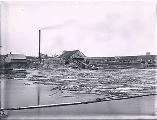
Bishop's Falls is a town in the north-central part of the island of Newfoundland in the Canadian province of Newfoundland and Labrador, with a population of 3,341 at the 2011 census.

The Exploits River is a river in the province of Newfoundland and Labrador, Canada. It flows through the Exploits Valley in the central part of Newfoundland.

Deer Lake is a town in the western part of the island of Newfoundland in the province of Newfoundland and Labrador, Canada.

Fortune is a Canadian town located in the province of Newfoundland and Labrador.
There are over a dozen lakes named Mud Lake within the U.S. state of Texas.
Little Bay is a town located in the Canadian province of Newfoundland and Labrador. Its current population is about 166 people. It is located in Green Bay, which is part of Notre Dame Bay, which is located in the central part of Newfoundland and Labrador. Some towns near Little Bay include Beachside, St Patrick's, Little Bay Islands, and the main center for Green Bay, Springdale.
Mud Lake is a small unincorporated community in central Labrador, Canada. It had a population of 50 as of 2016, a drop of 4 individuals from 2011. The town is not accessible by road. It is usually reached by crossing the Churchill River by boat or snowmobile.
Newfoundland and Labrador Route 350, commonly known as The Botwood Highway is a side highway in Central Newfoundland that leads from the Trans-Canada Highway in Bishop's Falls to Botwood, Point Leamington and Leading Tickles. It is approximately 70 km in length and contains several side roads to communities located off the route, such as Peterview, and Route 352 that leads to Point of Bay and the Cottrells Cove-Fortune Harbour area. Route 350-17 branches off in Point Leamington and connects the small community of Pleasantview to the main route. Route 350 continues on from Point Leamington for another 25 km north to Leading Tickles where the road officially ends. Along the way a short road connect Glover's Harbour to the main route as well.
Howley is a town in the Canadian province of Newfoundland and Labrador, with a population of 205. It is located on Route 401, 13 km from the Trans Canada Highway, approximately thirty minutes' drive from the Deer Lake Airport. Services include a pub, a convenience store, a bed and breakfast, a campground, and a hotel.

La Scie is a town in the Canadian province of Newfoundland and Labrador. The town had a population of 872 in the Canada 2016 Census, down from 899 in 2011.

Leading Tickles is a town in the Canadian province of Newfoundland and Labrador. In 2016, the town had a population of 292, down from 407 in the Canada 2006 Census. It is located approximately 25 km Northwest of Point Leamington on the shores of Notre Dame Bay. The town boasts spectacular scenery especially in spring and early summer when many ice bergs pass just off the coast.
Woodstock is a town in the Canadian province of Newfoundland and Labrador. The town had a population of 190 in 2016, unchanged from the Canada 2011 Census.
Green Bay is the name of two bays in the Canadian province of Newfoundland and Labrador.

The Hunt River greenstone belt, also called the Hunt River volcanic belt, is a northeast trending Mesoarchean greenstone belt in Newfoundland and Labrador, Canada, located along the coast of Labrador about 25 km (16 mi) west of the town of Hopedale. It is 70 km (43 mi) long and consists of metavolcanic and metasedimentary rocks.

Roberts Arm is a small town located near Crescent Lake, Newfoundland and Labrador, Canada in Division No. 8, Newfoundland and Labrador. It is found on the northern part of Newfoundland. Roberts Arm boasts of its Lake Monster, Cressie, which is claimed to be living in Crescent Lake. Recent years saw the development of a majestic hiking trail which encompasses the end of the lake nearest to the community, Hazelnut Adventure Trail.
Division No. 1, Subdivision L is an unorganized subdivision on the Avalon Peninsula in Newfoundland and Labrador, Canada. It is in Division 1 and contains the unincorporated communities of Bareneed, Black Duck Pond, Blow Me Down, Coley's Point South, Hibb's Cove, Pick Eyes, Port de Grave, Ship Cove and The Dock