Municipal District of Bonnyville No. 87

Last updated

Municipal District of Bonnyville No. 87
MD of Bonnyville AB sign.jpg
Welcome sign
Municipal Dost Bonnyville Flag.svg
Municipal District of Bonnyville No 87 Logo.svg
AB locator MUNICIPAL DISTRICT OF BONNYVILLE NO 87.svg
Location within Alberta
CountryCanada
Province Alberta
Region Northern Alberta
Planning region Lower Athabasca
Established1914
Incorporated1955
Government
[1]
   Reeve Barry Kalinski
  Governing body
M.D. of Bonnyville Council
  • Ed Duchesne
  • Ben Fadeyiw
  • Marc Jubinville
  • Mike Krywiak
  • Greg Sawchuck
  • Darcy Skarsen
  • Dana Swigart
  CAOAl Hoggan
   Administrative office Bonnyville
Area
 (2021) [2]
  Land6,005.3 km2 (2,318.7 sq mi)
Population
 (2021) [2]
  Total12,897
  Density2.1/km2 (5/sq mi)
   CSD
12,760
Time zone UTC−7 (MST)
  Summer (DST) UTC−6 (MDT)
Postal code
T0A 1S1
Website md.bonnyville.ab.ca

The Municipal District of Bonnyville No. 87 is a municipal district (MD) in northeastern Alberta, Canada in Division No. 12. On the east, it is adjacent to the province of Saskatchewan.

Contents

The district was incorporated on January 1, 1955, through the merger of the Municipal District of Bonnyville No. 87, the Municipal District of Glendon No. 88 and part of Improvement District No. 101. [3]

On May 1, 2021, the municipal district annexed the adjacent Improvement District No. 349. [4]

Geography

Communities and localities

The following Métis settlements and Indian reserves are within the MD of Bonnyville No. 87.

The following localities are within the MD of Bonnyville No. 87. [6] [7]

Localities

Demographics

As a census subdivision n the 2021 Census of Population conducted by Statistics Canada, the MD of Bonnyville No. 87 had a population of 12,897 living in 4,759 of its 5,487 total private dwellings, a change of

As a census subdivision in the 2016 Census of Population conducted by Statistics Canada, the MD of Bonnyville No. 87 originally had a population of 13,575 living in 4,820 of its 5,667 total private dwellings, a

The population of the MD of Bonnyville No. 87 according to its 2014 municipal census is 11,836, [13] a

Visible minorities and Aboriginals

The following is a breakdown of the visible minority and Aboriginal populations of the Bonnyville No. 87 census subdivision that includes the Elizabeth and Fishing Lake Metis settlements.

Visible minority and Aboriginal population (Canada 2006 Census)
Population groupPopulation % of total population
White 8,300
Visible minority group
Source: [14]
South Asian 0
Chinese 0
Black 20
Filipino 15
Latin American 20
Arab 0
Southeast Asian 0
West Asian 0
Korean 0
Japanese 0
Visible minority, n.i.e.0
Multiple visible minority0
Total visible minority population55
Aboriginal group
Source: [15]
First Nations 375
Métis 1,420
Inuit 0
Aboriginal, n.i.e.0
Multiple Aboriginal identity10
Total Aboriginal population1,815
Total population10,170100%

See also

Related Research Articles

<span class="mw-page-title-main">Bonnyville</span> Town in Alberta, Canada

Bonnyville is a town situated in East Northern Alberta, Canada between Cold Lake and St. Paul. The Municipal District (MD) of Bonnyville No. 87's surrounds the Town.

<span class="mw-page-title-main">Foothills County</span> Municipal district in Alberta, Canada

Foothills County is a municipal district in southern Alberta, Canada adjacent to the south side of Calgary in Census Division No. 6. Despite sharing a common border with the City of Calgary, it does not form part of the Calgary census metropolitan area (CMA) as defined by Statistics Canada. It is however a member municipality of the Calgary Metropolitan Region Board.

<span class="mw-page-title-main">Division No. 12, Alberta</span> Census division in Alberta, Canada

Division No. 12 is a census division in Alberta, Canada. Including the City of Cold Lake, the majority of the division is located in the northeast corner of central Alberta. The northern portion of the division is located within northern Alberta.

<span class="mw-page-title-main">Glendon, Alberta</span> Village in Alberta, Canada

Glendon is a village in northern Alberta, Canada that is north of St. Paul. The community has the maiden name of an early postmaster's mother.

<span class="mw-page-title-main">Yellowhead County</span> Municipal district in Alberta, Canada

Yellowhead County is a municipal district in west central Alberta, Canada. It is the only municipal district within Alberta census division No. 14.

<span class="mw-page-title-main">Lac La Biche County</span> Specialized municipality in Alberta, Canada

Lac La Biche County is a specialized municipality within Division No. 12 in northern Alberta, Canada. It was established through the amalgamation of the Town of Lac La Biche and Lakeland County in 2007.

<span class="mw-page-title-main">Big Lakes County</span> Municipal district in Alberta, Canada

Big Lakes County, formerly the Municipal District of Big Lakes, is a municipal district in north-central Alberta, Canada.

<span class="mw-page-title-main">Mackenzie County</span> Specialized municipality in Alberta, Canada

Mackenzie County is a specialized municipality in northern Alberta, Canada. It is located in Census Division 17, along the Mackenzie Highway. The municipal office is located in the hamlet of Fort Vermilion.

<span class="mw-page-title-main">Municipal District of Opportunity No. 17</span> Municipal district in Alberta, Canada

The Municipal District of Opportunity No. 17 is a municipal district (MD) occupying a remote area in central northern Alberta, Canada. Located in Census Division 17 north of the Town of Athabasca, its municipal office is located in the Hamlet of Wabasca.

<span class="mw-page-title-main">County of Northern Lights</span> Municipal district in Alberta, Canada

The County of Northern Lights is a municipal district in northwest Alberta, Canada. Located in Census Division 17, its municipal office is located in the Town of Manning.

<span class="mw-page-title-main">Municipal District of Smoky River No. 130</span> Municipal district in Alberta, Canada

The Municipal District of Smoky River No. 130 is a municipal district (MD) in northwestern Alberta, Canada. Located in Census Division No. 19, its municipal office is located in the Town of Falher.

<span class="mw-page-title-main">Municipal District of Wainwright No. 61</span> Municipal district in Alberta, Canada

The Municipal District of Wainwright No. 61 is a municipal district (MD) in eastern Alberta, Canada. Located in Census Division No. 7., its municipal office is located in the Town of Wainwright. The municipal district is bisected north-south by the Buffalo Trail and east-west by the Poundmaker Trail.

<span class="mw-page-title-main">Municipal District of Willow Creek No. 26</span> Municipal district in Alberta, Canada

The Municipal District of Willow Creek No. 26 is a municipal district (MD) in southern Alberta, Canada. Located in Census Division No. 3, its municipal office is located adjacent to Claresholm Industrial Airport, west of the Town of Claresholm.

<span class="mw-page-title-main">Smoky Lake County</span> Municipal district in Alberta, Canada

Smoky Lake County is a municipal district in north-eastern Alberta, Canada. Located in Census Division No. 12, its municipal office is located in the Town of Smoky Lake.

<span class="mw-page-title-main">Municipal District of Spirit River No. 133</span> Municipal district in Alberta, Canada

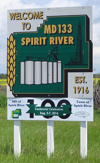
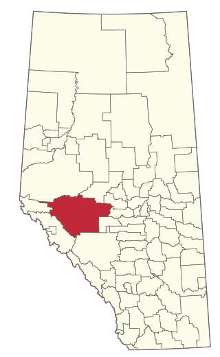
The Municipal District of Spirit River No. 133 is a municipal district (MD) in northwest Alberta, Canada, north of Grande Prairie. Located in the Upper Peace Region, its municipal office is located in the Town of Spirit River. With an area of 683.6 km2 (263.9 sq mi), it is the smallest municipal district in Alberta.

<span class="mw-page-title-main">Bonnyville Beach</span> Summer village in Alberta, Canada

Bonnyville Beach is a summer village in Alberta, Canada. It is located in the Municipal District of Bonnyville No. 87.

<span class="mw-page-title-main">Elizabeth Metis Settlement</span> Métis settlement in Alberta, Canada

Elizabeth Métis Settlement is a Métis settlement in central Alberta, Canada within the Municipal District of Bonnyville No. 87. It was founded in 1939 after the introduction of the Metis Betterment Act. It is located approximately 20 km (12 mi) east of Highway 897 and 39 km (24 mi) south of Cold Lake and comprises 25,641 hectares of land. Industries such as oil, gas, forestry, and construction are commonly practiced by members of the settlement.

<span class="mw-page-title-main">Improvement District No. 349</span> Former improvement district in Alberta, Canada

Improvement District No. 349 was an improvement district in northeast Alberta, Canada that existed between January 1, 2012 and May 1, 2021. The improvement district was largely coextensive with the Alberta portion of the Cold Lake Air Weapons Range. On May 1, 2021, the improvement district was annexed by the adjacent Municipal District (MD) of Bonnyville No. 87.

References

  1. "Municipal Officials Search". Alberta Municipal Affairs. May 9, 2019. Retrieved October 1, 2021.
  2. 1 2 3 "Population and dwelling counts: Canada, provinces and territories, and census subdivisions (municipalities)". Statistics Canada. February 9, 2022. Retrieved February 9, 2022.
  3. Bonnyville Municipal profile - Alberta Municipal Affairs
  4. "O.C. 121/2021". Government of Alberta. April 28, 2021. Retrieved April 28, 2021.
  5. "Cold Lake, City (Census Subdivision), Alberta". Statistics Canada. June 20, 2012. Retrieved August 13, 2012.
  6. 1 2 3 "Specialized and Rural Municipalities and Their Communities" (PDF). Alberta Municipal Affairs. January 12, 2022. Retrieved January 21, 2022.
  7. "Standard Geographical Classification (SGC) 2006, Economic Regions: 4812004 - Bonnyville No. 87, geographical codes and localities, 2006". Statistics Canada. March 5, 2010. Retrieved August 11, 2012.
  8. 1 2 "Population and dwelling counts, for Canada, provinces and territories, and census subdivisions (municipalities), 2016 and 2011 censuses – 100% data (Alberta)". Statistics Canada. February 8, 2017. Retrieved February 8, 2017.
  9. "Population and dwelling counts, for Canada, provinces and territories, and designated places, 2016 and 2011 censuses – 100% data (Alberta)". Statistics Canada. February 8, 2017. Retrieved February 9, 2017.
  10. 1 2 "Population and dwelling count amendments, 2016 Census". Statistics Canada. November 15, 2017. Retrieved December 9, 2017.
  11. 2017 Municipal Affairs Population List (PDF). Alberta Municipal Affairs. ISBN   978-1-4601-3652-2 . Retrieved February 10, 2018.
  12. 1 2 "2012 Municipal Affairs Population List" (PDF). Alberta Municipal Affairs. November 22, 2012. Retrieved January 6, 2013.
  13. "Council Highlights". Municipal District of Bonnyville No. 87. June 25, 2014. Retrieved June 26, 2014.
  14. Community Profiles from the 2006 Census, Statistics Canada - Census Subdivision
  15. Aboriginal Population Profile from the 2006 Census, Statistics Canada - Census Subdivision