
Nesset is a municipality in Møre og Romsdal county, Norway on the Romsdal Peninsula. The administrative centre is the village of Eidsvåg. Other population centers include Rausand, Boggestranda, Myklebostad, Eresfjord, and Eikesdalen.

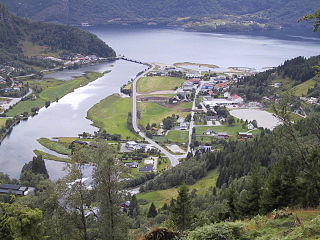
Eidsvåg is a village in Nesset Municipality in Møre og Romsdal county, Norway. It is the administrative centre of the municipality. Eidsvåg is located at the end of the Langfjorden on the isthmus connecting the Romsdal peninsula to the Norwegian mainland. It is located about 8.5 kilometres (5.3 mi) southwest of the village of Raudsand, about 20 kilometres (12 mi) north of the village of Eresfjord, and 9 kilometres (5.6 mi) north of the village of Boggestranda. Nesset Church is located in this village.
Skjolden is a village in the municipality of Luster in Sogn og Fjordane county, Norway. It is located at the end of the Lustrafjorden, a branch of the Sognefjorden. Skjolden is located at the innermost point of the Sognefjorden, Norway's longest fjord, and the length of the Sognefjorden is measured from Skjolden to the island of Ytre Sula where the fjord meets the ocean—over 200 km. The valleys of Mørkridsdal and Fortunsdal meet at Skjolden, just west of the Hurrungane mountains. Skjolden is home to about 200 people.

Laudal is a village in Marnardal municipality in Vest-Agder county, Norway. The village is located on the western shore of the Mandalselva river, about 15 kilometres (9.3 mi) south of the village of Bjelland and about 9 kilometres (5.6 mi) north of the village of Øyslebø. The village of Laudal has 191 residents (2001). Laudal was the administrative centre of the old municipality of Laudal which existed from 1899 until its dissolution in 1964. Laudal Church is located in the small village.

Sæbø is a village in Ørsta Municipality in Møre og Romsdal county, Norway. The village is located along the Hjørundfjorden in the Bondalen valley. It is about 5 kilometres (3.1 mi) north of the mountain Skårasalen. The village of Store-Standal lies about 6 kilometres (3.7 mi) to the north and the villages of Leira and Bjørke lie about 11 kilometres (6.8 mi) to the south.
Eresfjord og Vistdal is a former municipality in Møre og Romsdal county, Norway. The municipality encompassed all of the present-day Nesset Municipality that lies south of the Langfjorden and around the Eresfjorden. The administrative centre of the municipality was the village of Eresfjord. The municipality included the two parishes of Vistdal and Eresfjord and there were two churches in the municipality: Sira Church in Eresfjord and Vistdal Church in Myklebostad.

Viddalsdammen is a lake and a reservoir in the municipality of Aurland in Sogn og Fjordane county, Norway. The reservoir has an area of 4.13-square-kilometre (1.59 sq mi) and the elevation varies between 930 metres (3,050 ft) and 868 m (2,848 ft) above sea level. Viddalsdammen is located at the end of the Låvisdalen valley, about 11 kilometres (6.8 mi) southeast of Aurlandsvangen, about 7 kilometres (4.3 mi) southeast of Flåm, and about 6 kilometres (3.7 mi) northeast of Myrdal Station.

Leinesfjord or Myklebostad is the administrative centre of the municipality of Steigen in Nordland county, Norway. The village is located about 10 kilometres (6.2 mi) west of the village of Nordfold along the Leinesfjorden, the fjord after which the village is named. The local school is located here as well as Leinesfjord Chapel.
Myklebostad may refer to the following locations:

Skjorta is a mountain in the municipality of Nesset in Møre og Romsdal county, Norway. The mountain is located 5 kilometres (3.1 mi) southeast of the Eresfjorden, 5 kilometres (3.1 mi) north of the lake Eikesdalsvatnet and the mountain Fløtatinden, 5 kilometres (3.1 mi) east of the Eira River and the village of Eresfjord, and 1.5 kilometres (0.93 mi) west of the municipal border with Sunndal. From the summit, there is a view of Mardalsfossen, about 20 kilometres (12 mi) to the south.

Hornindalsrokken is a 1,529-metre (5,016 ft) tall mountain in Norway. It is located on the border of three municipalities in two different counties: Stranda Municipality and Ørsta Municipality in Møre og Romsdal county and Hornindal Municipality in Sogn og Fjordane county. The mountain is sometimes also called Honndalsrokken or sometimes just Rokken or Rokkjen.

The Eira River is a river in Nesset Municipality in Møre og Romsdal county, Norway. The 7-kilometre (4.3 mi) long river flows from the lake Eikesdalsvatnet past the village of Eresfjord and into the Eresfjorden. The mountain Skjorta lies 5 kilometres (3.1 mi) east of the river.

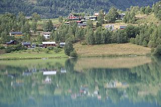
Boggestranda is a village in Nesset Municipality in Møre og Romsdal county, Norway. It is located along the east shore of the Eresfjorden, about 10 kilometres (6.2 mi) south of the village of Eidsvåg and 10 kilometres (6.2 mi) north of the village of Eresfjord. There are some very old rock carvings in Boggestranda.

Eikesdalen is a valley and a settlement in Nesset Municipality in Møre og Romsdal county, Norway. The river Aura flows through the valley. The village is located at the south end of the lake Eikesdalsvatnet at the mouth of the Aura River. Most of the valley is filled by the lake and until 1991 ferry on the lake was the only access between north and south of the valley.. The Mardalsfossen waterfall lies about 2.5 kilometres (1.6 mi) northwest of the village. Most of the river Aura is diverted to Sunndalen and used in the power station there. The village of Eresfjord is located about 25 kilometres (16 mi) north, at the other end of the lake. The lake Aursjøen lies about 20 kilometres (12 mi) southeast of Eikesdalen village. Eikesdal Church is located in this village.

Vistdal Church is a parish church in Nesset Municipality in Møre og Romsdal county, Norway. It is located in the village of Myklebostad. The church is part of the Vistdal parish in the Indre Romsdal deanery in the Diocese of Møre. The white wooden church was built in 1869 by the architect Jacob Wilhelm Nordan. The church seats about 270 people.
Naustdal is the administrative centre of Naustdal Municipality in Sogn og Fjordane county, Norway. The village is located on the northern shore of the Førdefjorden at the mouth of the river Nausta, which flows through the Naustdalen valley. The village sits about 12 kilometres (7.5 mi) northwest of the town of Førde and about 10 kilometres (6.2 mi) northeast of the village of Helle. Kletten Hill rises southeast of the village.

Haukedalen is a village in Førde Municipality in Sogn og Fjordane county, Norway. The village is located in the Haukedalen valley at the northwestern end of the lake Haukedalsvatnet. The village lies in a fairly remote valley surrounded by the Gaularfjellet mountains. The town of Førde lies about 35 kilometres (22 mi) to the west. Haukedalen Church is located in the village. The glaciers Grovabreen and Jøstafonn are both about 10 kilometres (6.2 mi) to the northeast and east respectively.

Feios is a village in Vik Municipality in Sogn og Fjordane county, Norway. The village is located on the southern shore of the Sognefjorden, about 8 kilometres (5.0 mi) southeast of the village of Vangsnes and about 17 kilometres (11 mi) northwest of the village of Fresvik. The village lies in a small, narrow valley, surrounded by large mountains, with the river Feioselvi running through the center of the valley. Feios Church is located in the village.


