Dziankówek is a village in the administrative district of Gmina Lubień Kujawski, within Włocławek County, Kuyavian-Pomeranian Voivodeship, in north-central Poland.

Olchowiec-Kolonia is a village in the administrative district of Gmina Wierzbica, within Chełm County, Lublin Voivodeship, in eastern Poland. It lies approximately 5 kilometres (3 mi) south-west of Wierzbica, 17 km (11 mi) north-west of Chełm, and 50 km (31 mi) east of the regional capital Lublin.
Krzyżyki is a settlement in the administrative district of Gmina Czarna Białostocka, within Białystok County, Podlaskie Voivodeship, in north-eastern Poland. It lies approximately 4 kilometres (2 mi) south-west of Czarna Białostocka and 19 km (12 mi) north of the regional capital Białystok.
Stary Szor is a village in the administrative district of Gmina Sokółka, within Sokółka County, Podlaskie Voivodeship, in north-eastern Poland, close to the border with Belarus. It lies approximately 13 kilometres (8 mi) south-west of Sokółka and 29 km (18 mi) north of the regional capital Białystok.
Działy is a settlement in the administrative district of Gmina Dąbrowice, within Kutno County, Łódź Voivodeship, in central Poland.
Gieski is a village in the administrative district of Gmina Rozprza, within Piotrków County, Łódź Voivodeship, in central Poland.
Prandocin-Iły is a village in the administrative district of Gmina Słomniki, within Kraków County, Lesser Poland Voivodeship, in southern Poland. It lies approximately 4 kilometres (2 mi) north of Słomniki and 27 km (17 mi) north-east of the regional capital Kraków.
Goźlin Górny is a village in the administrative district of Gmina Wilga, within Garwolin County, Masovian Voivodeship, in east-central Poland.
Białka is a village in the administrative district of Gmina Szczawin Kościelny, within Gostynin County, Masovian Voivodeship, in east-central Poland.
Poręby Stare is a village in the administrative district of Gmina Dobre, within Mińsk County, Masovian Voivodeship, in east-central Poland.
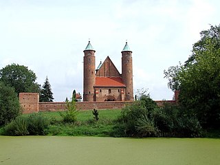
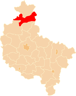
Brochów is a village in Sochaczew County, Masovian Voivodeship, east-central Poland. It is the seat of Gmina Brochów and lies some 11 kilometres (7 mi) north of Sochaczew and 52 km (32 mi) west of Warsaw.
Janówek is a village in the administrative district of Gmina Brochów, within Sochaczew County, Masovian Voivodeship, in east-central Poland.
Kamienica is a village in the administrative district of Gmina Kazimierz Biskupi, within Konin County, Greater Poland Voivodeship, in west-central Poland.
Pierwoszewo is a village in the administrative district of Gmina Wronki, within Szamotuły County, Greater Poland Voivodeship, in west-central Poland.
Rudna is a village in the administrative district of Gmina Złotów, within Złotów County, Greater Poland Voivodeship, in west-central Poland. It lies approximately 15 kilometres (9 mi) east of Złotów and 105 km (65 mi) north of the regional capital Poznań.
Łoskajmy is a village in the administrative district of Gmina Bartoszyce, within Bartoszyce County, Warmian-Masurian Voivodeship, in northern Poland, close to the border with the Kaliningrad Oblast of Russia.
Malinowo is a settlement in the administrative district of Gmina Górowo Iławeckie, within Bartoszyce County, Warmian-Masurian Voivodeship, in northern Poland, close to the border with the Kaliningrad Oblast of Russia.
Jeleń is a settlement in the administrative district of Gmina Piecki, within Mrągowo County, Warmian-Masurian Voivodeship, in northern Poland.
Zembrzus-Mokry Grunt is a village in the administrative district of Gmina Janowo, within Nidzica County, Warmian-Masurian Voivodeship, in northern Poland. It lies approximately 18 kilometres (11 mi) south-east of Nidzica and 57 km (35 mi) south of the regional capital Olsztyn.
Błotno is a village in the administrative district of Gmina Dobrzany, within Stargard County, West Pomeranian Voivodeship, in north-western Poland. It lies approximately 6 kilometres (4 mi) south-east of Dobrzany, 31 km (19 mi) east of Stargard, and 61 km (38 mi) east of the regional capital Szczecin.