Nahant Beach Boulevard

Last updated

Nahant Beach Boulevard-Metropolitan Park System of Greater Boston
USA Massachusetts location map.svg
Red pog.svg
Usa edcp location map.svg
Red pog.svg
Location Lynn and Nahant, Massachusetts
Coordinates 42°26′12″N70°56′17″W / 42.43667°N 70.93806°W / 42.43667; -70.93806 Coordinates: 42°26′12″N70°56′17″W / 42.43667°N 70.93806°W / 42.43667; -70.93806
Built1936
ArchitectEliot, Charles; et al.
MPS Metropolitan Park System of Greater Boston MPS
NRHP reference # 03000747 [1]
Added to NRHPAugust 11, 2003

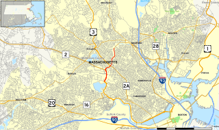
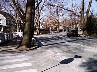
Nahant Beach Boulevard, also Nahant Causeway and Nahant Road is a historic road on the isthmus connecting Nahant, Massachusetts to the mainland at Lynn, Massachusetts. The road runs from the Lynn Rotary, its junction with Lynn Shore Drive and the Lynnway, about 1.5 miles (2.4 km) to Wilson Road in Nahant. It passes through Nahant Beach Reservation, a state park offering beach access on the isthmus. The road offers expansive views of the area coastlines and Boston Harbor. [2] Both the park and the roadway are administered by the Massachusetts Department of Conservation and Recreation.

Isthmus Narrow strip of land connecting two larger land areas

An isthmus is a narrow piece of land connecting two larger areas across an expanse of water by which they are otherwise separated. A tombolo is an isthmus that consists of a spit or bar, and a strait is the sea counterpart of an isthmus.

Nahant, Massachusetts Town in Massachusetts, United States

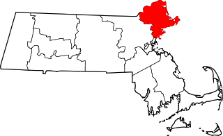
Nahant is a town in Essex County, Massachusetts, United States. The population was 3,410 at the 2010 census, which makes it the smallest municipality by population in Essex County. With just 1.0 square mile (2.7 km2) of land area, it is the smallest municipality by area in the state. It is primarily a residential community.

Lynn, Massachusetts City in Massachusetts, United States

Lynn is the 9th largest municipality in Massachusetts and the largest city in Essex County. Situated on the Atlantic Ocean, 3.7 miles (6.0 km) north of the Boston city line at Suffolk Downs, Lynn is part of Greater Boston's urban inner core. Settled by Europeans in 1629, Lynn is the 5th oldest colonial settlement in the Commonwealth. An early industrial center, Lynn was long colloquially referred to as the "City of Sin", owing to its historical reputation for crime and vice. Today, however, the city is known for its contemporary public art, international population, historic architecture, downtown cultural district, loft-style apartments, and public parks and open spaces, which include the oceanfront Lynn Shore Reservation; the 2,200-acre, Frederick Law Olmsted-designed Lynn Woods Reservation; and the High Rock Tower Reservation. Lynn also is home to Lynn Heritage State Park, the southernmost portion of the Essex Coastal Scenic Byway, and the seaside, National Register-listed Diamond Historic District.

Nahant Beach Boulevard was first laid out in 1905, as part of the Metropolitan District Commission's program of developing oceanfront parkways, and provided the first paved road access to Nahant. It was designed by the firm of Olmsted, Olmsted, and Eliot, predecessor to the Olmsted Brothers landscape design firm. Around the same time, rail access and a bridle path were also added to the isthmus. [2]

Department of Conservation and Recreation

The Department of Conservation and Recreation (DCR) is a state agency of the Commonwealth of Massachusetts, situated in the Executive Office of Energy and Environmental Affairs. It is best known for its parks and parkways. As of December 9, 2015, the Commissioner of the DCR is Leo Roy. The DCR's mission is "To protect, promote and enhance our common wealth of natural, cultural and recreational resources for the well-being of all." The agency is the largest landowner in Massachusetts.

Olmsted Brothers landscape design firm

The Olmsted Brothers company was an influential landscape architectural firm in the United States, established in 1898 by brothers John Charles Olmsted (1852–1920) and Frederick Law Olmsted, Jr. (1870–1957), sons of the eminent landscape architect Frederick Law Olmsted.

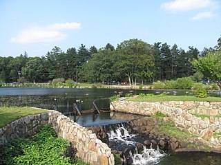
In 1936 that roadway alignment was converted into a parking area, and the present roadway was completed the following year on the alignment of the railroad bed. The Lynn Rotary was completed in 1935. This work, along with the conversion of the bridle path to a promenade, was paid for by Works Progress Administration grants. Since then modifications to the roadway have been modest. Seawalls have been built, a chain link fence was installed on the wall between the road and the parking lot, and the rotary was landscaped. [2]

Works Progress Administration largest and most ambitious United States federal government New Deal agency

The Works Progress Administration was an American New Deal agency, employing millions of people to carry out public works projects, including the construction of public buildings and roads. It was established on May 6, 1935, by Executive Order 7034. In a much smaller project, Federal Project Number One, the WPA employed musicians, artists, writers, actors and directors in large arts, drama, media, and literacy projects. The four projects dedicated to these were: the Federal Writers’ Project (FWP), the Historical Records Survey (HRS), the Federal Theatre Project (FTP), the Federal Music Project (FMP), and the Federal Art Project (FAP). In the Historical Records Survey, for instance, many former slaves in the South were interviewed; these documents are of great importance for American history. Theater and music groups toured throughout America, and gave more than 225,000 performances. Archaeological investigations under the WPA were influential in the rediscovery of pre-Columbian Native American cultures, and the development of professional archaeology in the US.

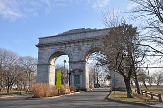
When the roadway was listed on the National Register of Historic Places in 2003, the designation included, in addition to the roadway itself, the Lynn Rotary and the Spanish–American War Memorial located in the rotary; a second memorial, the Aliferis Monument, postdates the period of significance for the listing. [2]

National Register of Historic Places federal list of historic sites in the United States

The National Register of Historic Places (NRHP) is the United States federal government's official list of districts, sites, buildings, structures, and objects deemed worthy of preservation for their historical significance. A property listed in the National Register, or located within a National Register Historic District, may qualify for tax incentives derived from the total value of expenses incurred preserving the property.

Spanish–American War Conflict in 1898 between Spain and the United States

The Spanish–American War was an armed conflict between Spain and the United States in 1898. Hostilities began in the aftermath of the internal explosion of USS Maine in Havana harbor in Cuba, leading to U.S. intervention in the Cuban War of Independence. The war led to emergence of U.S. predominance in the Caribbean region, and resulted in U.S. acquisition of Spain's Pacific possessions. That led to U.S. involvement in the Philippine Revolution and ultimately in the Philippine–American War.

Nahant Beach Boulevard MA.jpg

See also

National Register of Historic Places listings in Lynn, Massachusetts Wikimedia list article

This is a list of the National Register of Historic Places listings in Lynn, Massachusetts.

National Register of Historic Places listings in Essex County, Massachusetts Wikimedia list article

This list is of that portion of the National Register of Historic Places (NRHP) designated in Essex County, Massachusetts. The locations of these properties and districts for which the latitude and longitude coordinates are included below, may be seen in a map.

Related Research Articles

Charles Eliot (landscape architect) landscape architect

Charles Eliot was an American landscape architect. Known for pioneering principles of regional planning, naturalistic systems approach to landscape architecture, and laying the groundwork for conservancies across the world. Instrumental in the formation of The Trustees of Reservations, the world's first land trust, playing a central role in shaping the Boston Metropolitan Park System, designing a number of public and private landscapes, and wrote prolifically on a variety of topics.

Baxter Boulevard

Baxter Boulevard is a road and parkway that wraps around the west side of Back Cove. The roadway served as the means to head north from downtown Portland before Tukey's Bridge, now on I-295, was built. The road was part of US Route 1 until May 2007.

Revere Beach Parkway Parkway near Boston, Massachusetts, USA

Revere Beach Parkway is a historic parkway in the suburbs immediately north of Boston, Massachusetts. It begins at Wellington Circle in Medford, where the road leading to the west is the Mystic Valley Parkway, and the north-south road is the Fellsway, designated Route 28. The parkway proceeds east, ending at Eliot Circle, the junction of Revere Beach Boulevard and Winthrop Parkway in Revere. In between, the parkway passes through the towns of Everett and Chelsea. The parkway was built between 1896 and 1904 to provide access from interior communities to Revere Beach. It underwent two major periods of capacity expansion, in the 1930s and again in the 1950s. The parkway is designated as part of Route 16 west of Route 1A, and as part of Route 145 east of that point.

Alewife Brook Parkway highway in Massachusetts

Alewife Brook Parkway is a short parkway in Cambridge and Somerville, Massachusetts. It is listed on the National Register of Historic Places. It begins at Fresh Pond in Cambridge, and heads north on the east bank of Alewife Brook, crossing into West Somerville and ending at the Mystic River on the Medford town line, where it becomes Mystic Valley Parkway. The entire length of Alewife Brook Parkway is designated as part of Massachusetts Route 16 (Route 16), while the southernmost sections are also designated as part of Route 2 and U.S. Route 3 (US 3). It is managed by the Department of Conservation and Recreation with the Massachusetts Department of Transportation responsible for bridge maintenance.

Mystic Valley Parkway

The Mystic Valley Parkway is a parkway in Arlington, Medford, Somerville, and Winchester, Massachusetts. It is listed on the National Register of Historic Places, and forms part of Route 16.

Lynn Fells Parkway

Lynn Fells Parkway is a parkway in Greater Boston, Massachusetts, in the United States. It is maintained by the Massachusetts Department of Conservation and Recreation. The road runs from the end of Fellsway East in Stoneham, eastward through Melrose, and ends in Saugus at US Route 1. The parkway serves as a connector between the Middlesex Fells Reservation and Breakheart Reservation.

Stony Brook Reservation Parkways Historic district in Massachusetts

The Stony Brook Reservation Parkways are a group of historic parkways in Boston and Dedham, Massachusetts. They provide access to and within the Stony Brook Reservation, a Massachusetts state park. The roadways and the park are administered by the Massachusetts Department of Conservation and Recreation, a successor to the Metropolitan District Commission, which oversaw their construction. The roads consist of the Dedham, Enneking, and Turtle Pond Parkways and West Boundary Road. Two roads within the park, Smithfield Road and Reservation Road, are listed as non-contributing properties. The park roads were built between 1894 and 1956, and were listed on the National Register of Historic Places in 2006.

Winthrop Parkway Parkway in Revere, Massachusetts

Winthrop Parkway is a historic parkway in Revere, Massachusetts. The parkway, built between 1909 and 1919 and now designated as part of Route 145, runs for about 0.75 miles (1.21 km), from Eliot Circle southeast to the Revere-Winthrop line. Acquisitions for its construction represent the last public purchase of oceanfront lands in Revere. It was listed on the National Register of Historic Places in 2004.

Fresh Pond Parkway highway in Massachusetts

Fresh Pond Parkway is an historic park and parkway, found in the westernmost neighborhoods of Cambridge, Massachusetts. The parkway was built in 1899 and added to the National Register of Historic Places in 2005.

D.W. Field Park

D.W. Field Park is a municipal park managed by the parks department of the city of Brockton, Massachusetts. The park consists of 650 acres (260 ha) of fields, woodlands, and water bodies in northern Brockton and southern Avon, Massachusetts, and is owned by both municipalities. It was created in 1925 as a bequest from Brockton businessman Daniel W. Field, and was designed by Frederick Law Olmsted and his son, John Charles Olmsted. Its landscape is dominated by a chain of seven water bodies, all but one of which are man-made, impounding Beaver Brook. The oldest of them, Cross Pond, was created in the 1790s; these lakes, ponds, and reservoirs, were, with one exception, created before the park was laid out, and served either agricultural or industrial purposes. Waldo Lake was created in the 1930s as part of the park's design.

Greenlawn Cemetery (Nahant, Massachusetts)

Greenlawn Cemetery is a historic cemetery at 195 Nahant Road in Nahant, Massachusetts. Development of the 5.7-acre (2.3 ha) cemetery was one of the first civic projects of the town of Nahant after its separation from adjacent Lynn in 1853. The cemetery was established in 1856 on 2 acres (0.81 ha) of land, and has been extended several times to its present size. Its dominant feature is the Ellingwood Chapel, a Gothic Revival structure built in 1920. A 3.9-acre (1.6 ha) portion of the cemetery was listed on the National Register of Historic Places in 2000.

Pulaski Park (Holyoke, Massachusetts) park in Holyoke, Massachusetts

Pulaski Park is a city park along the Connecticut River in Holyoke, Massachusetts. Originally called Prospect Park when it was laid out in 1884, it was given its present name in 1939 in honor of American Revolutionary War hero Casimir Pulaski, for whom there is a memorial in the park's center. The original 5.1-acre (2.1 ha) park was designed by the Olmsted Brothers landscape design firm.

Tavern Acres Historic District

The Tavern Acres Historic District encompasses a residential development known as Tavern Acres, which was built in the 1920s with a landscape design by Henry Vincent Hubbard, then with the Olmsted Brothers landscape design firm. It is bounded by Bradstreet Rd., Green and Main Sts. and Park Way in North Andover, Massachusetts. The district encompasses Memorial Park, the Stevens Library, and properties facing Memorial Park and further along Bradstreet Road. The district was listed on the National Register of Historic Places in 1995.

Fells Connector Parkways historic district in the United States

The Fells Connector Parkways are a group of historic parkways in the cities of Malden and Medford, Massachusetts, suburbs north of the city of Boston. The three parkways, The Fellsway, Fellsway West, and Fellsway East serve to provide access from the lower portion of the Mystic River Reservation to the Middlesex Fells Reservation. The latter two parkways continue northward, providing access to the interior of the Fells and providing a further connection to the Lynn Fells Parkway. Significant portions of these parkways south of the Fells, which were among the first connecting parkways designed to be part of the Metropolitan Park System of Greater Boston by Charles Eliot, were listed on the National Register of Historic Places in 2003.

Middlesex Fells Reservation Parkways

The Middlesex Fells Reservation Parkways are the roadways within and bordering on the Middlesex Fells Reservation, a state park in the northern suburbs of Boston, Massachusetts. The park includes portions of the towns of Malden, Medford, Melrose, Stoneham, and Winchester. The roads inside the park and around its perimeter have been listed on the National Register of Historic Places. Other portions of some of the roads are covered by more than one listing in the national register; see Fellsway Connector Parkways and Middlesex Fells Reservoirs Historic District.

Blue Hills Parkway road in Massachusetts, USA

Blue Hills Parkway is a historic parkway that runs in a straight line from a crossing of the Neponset River, at the south border of Boston to the north edge of the Blue Hills Reservation in Milton, Massachusetts. It was built in 1893 to a design by the noted landscape architect, Charles Eliot, who is perhaps best known for the esplanades along the Charles River. The parkway is a connecting road between the Blue Hills Reservation and the Neponset River Reservation, and was listed on the National Register of Historic Places in 2003.

Old Harbor Reservation Parkways

The Old Harbor Reservation Parkways are three historic roads in the Old Harbor area of Boston. They are part of the Boston parkway system designed by Frederick Law Olmsted. They include

Nahant Beach Reservation

Nahant Beach Reservation is a protected coastal reservation covering 67 acres (27 ha) of beach and recreational areas in the town of Nahant, Massachusetts. Nahant Road, formerly known as Nahant Beach Boulevard when it was added to the National Register of Historic Places in 2003, offers access to 7,000-foot-long (2,100 m) Long Beach on the Atlantic Ocean side to the east. The reservation includes a boat ramp with access to Lynn Harbor and shares athletic fields with Lynn Shore Reservation in the area around Nahant Rotary, a traffic circle at the reservation's northern end. The reservation is part of the Metropolitan Park System of Greater Boston.

Seaside Park (Connecticut) park in Bridgeport, Connecticut

Seaside Park, located in Bridgeport, Connecticut, is a 2.5-mile (4.0 km) long crescent-shaped park bordering Bridgeport Harbor, Long Island Sound, and Black Rock Harbor. The park lies within Bridgeport's South End neighborhood.

References

  1. National Park Service (2008-04-15). "National Register Information System". National Register of Historic Places . National Park Service.
  2. 1 2 3 4 "NRHP nomination for Nahant Beach Boulevard". Commonwealth of Massachusetts. Retrieved December 21, 2013.