
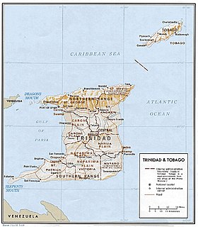
Trinidad and Tobago is an archipelagic republic in the southern Caribbean between the Caribbean Sea and the North Atlantic Ocean, northeast of Venezuela. They are southeasterly islands of the Lesser Antilles, Monos, Huevos, Gaspar Grande, Little Tobago, and St. Giles Island. Trinidad is 11 km (6.8 mi) off the northeast coast of Venezuela and 130 km (81 mi) south of the Grenadines. The island measures 4,768 km2 (1,841 sq mi) in area with an
average length of 80 km (50 mi) and an average width of 59 km (37 mi). The island appears rectangular in shape with three projecting peninsular corners. Tobago is 30 km (19 mi) northeast of Trinidad and measures about 298 km2 (115 sq mi) in area, or 5.8% of the country's area, 41 km (25.5 mi) in length and 12 km (7.5 mi) at its greatest width. The island is cigar-shaped in appearance, with a northeast-southwest alignment.

The Trinidad piping guan locally known as the pawi, is a bird in the chachalaca, guan and curassow family Cracidae, endemic to the island of Trinidad. It is a large bird, somewhat resembling a turkey in appearance, and research has shown that its nearest living relative is the blue-throated piping guan from South America. It is a mainly arboreal species feeding mostly on fruit, but also on flowers and leaves. At one time abundant, it has declined in numbers and been extirpated from much of its natural range and the International Union for Conservation of Nature has rated the bird as "critically endangered".
The Northern Range is the range of tall hills across north Trinidad, the major island in the Republic of Trinidad and Tobago. The hills range from the Chaguaramas peninsula on the west coast to Toco in the east.
The Northern Range covers approximately twenty-five percent of the land area of Trinidad.

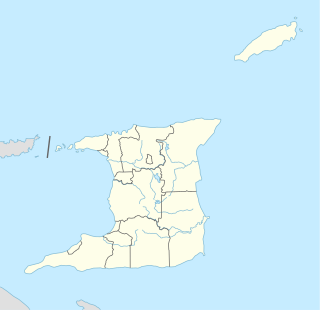
Mayaro is the name of a county on southeastern Trinidad island, in Trinidad and Tobago.
Caroni County is a historic county of Trinidad and Tobago. It occupies 557 km2 (215 sq mi) in the west central part of the island of Trinidad, the larger island in the Republic of Trinidad and Tobago. It lies south and southwest of Saint George County, west of Nariva County and north of Victoria County. To the west it is bounded by the Gulf of Paria. County Caroni includes the towns of Chaguanas, the largest town in the country and Couva, the capital of the Couva–Tabaquite–Talparo region. Administratively it is divided between the Borough of Chaguanas, the Couva–Tabaquite–Talparo Regional Corporation and the Tunapuna–Piarco Regional Corporation. The county was divided into four Wards: Chaguanas, Couva, Cunupia and Montserrat. The major towns of County Caroni are Chaguanas and Couva. The port and industrial zone of Point Lisas is located in Caroni, and the region is also a site for agriculture.
Nariva is a county in Trinidad and Tobago. It is located in eastern Trinidad, south of Saint Andrew County and north of Mayaro County, to the west by Victoria County and to the northwest by Saint George County. The southern boundary of the county lies along the Ortoire River and the western boundary is Cocos Bay. The towns of Rio Claro and Ecclesville are located in Nariva County. The Nariva Swamp is located in the eastern part of Nariva County.
Victoria was county on Trinidad island in Trinidad and Tobago.
The counties of Trinidad and Tobago are historic administrative divisions of Trinidad and Tobago. Trinidad was divided into eight counties, and these counties were subdivided into wards. Tobago was administered as a ward of Saint David County.
Saint Andrew is a county in Trinidad and Tobago which occupies 740 km2 (290 sq mi). It is located in northeastern Trinidad, east of Saint George County, south of Saint David County and north of Nariva County. To the east it is bounded by the Atlantic Ocean. The major town in the county is Sangre Grande. Saint Andrew is divided into five Wards - Valencia, Matura, Manzanilla, Tamana and Turure.
Biche is a village in east Trinidad and Tobago 18 kilometers south of Sangre Grande and 18 kilometers north of Rio Claro.

The Ortoire River is a river in Trinidad and Tobago. It forms the boundary between Nariva County and Mayaro County in east Trinidad.
On the island of Trinidad, the Naparima Plain is a broad lowland area on the west between the Central Range and the Southern Range ; the lowland area on the east is the Nariva Plain. To the north of the Central Range is the Caroni Plain. The Oropouche river flows through the Naparima Plain and drains into the Oropouche Lagoon, a swampy area, on the Gulf of Paria coast. The northern region of the Naparima Plain has alluvial soil; the southern region is sandy and less fertile.
8bnjakknzOn the island of Trinidad, the Nariva Plain is a lowland area on the east between the Central Range and the Southern Range; the lowland area on the west is the Naparima Plain. To the north of the Central Range is the Caroni Plain. The lowland areas are either flat or consisting of gently rolling hills. The eastern half of the island not as thickly settled as the western. The 35-mile long Ortoire river flows eastward through the Nariva Plain and drains in the Nariva Swamp on the Atlantic Ocean coast.
On the island of Trinidad in the Republic of Trinidad and Tobago, the Caroni Plain is a lowland area between the Northern Range and the Central Range. The lowland areas to the south of the Central Range are the Naparima Plain on the west and the Nariva Plain on the east. The lowland areas are either flat or consist of gently rolling hills. The 25-mile long Caroni river flows westward through the Caroni Plain and drains into the Caroni Swamp on the Gulf of Paria coast. The Caroni Plain was a major region of sugar and cocoa production in the 18th and 19th centuries and the first half of the 20th century.
On the island of Trinidad, the Southern Range is a discontinuous chain of low hills along the southern coast, reaching their highest altitude in the 1,000 feet (300 m) high Trinity Hills of the southeast. According to legend, the sight of the three neighboring hilltops of the then unnamed Trinity Hills, led to Christopher Columbus, on his third voyage to the New World, to name the island, "Trinidad." The broad lowland area on the west between the Southern Range and the Central Range is the Naparima Plain; the lowland area on the east is the Nariva Plain. The Oropuche river flows through the Naparima Plain and drains into the Oropuche Lagoon, a swampy area, on the Gulf of Paria coast, whereas the 31-mile long Ortoire River flows through the Nariva Plain and drains into the Nariva Swamp on the Atlantic Ocean coast. The Southern region of the island has sandy and less fertile soil. The Southern Range, particularly its Western and Central parts, consists of unconsolidated segments.

The Nariva Formation is a geologic formation in Trinidad and Tobago. It preserves fossils dating back to the Paleogene period.

