Narooma, New South Wales

Last updated

Narooma
New South Wales
NaroomaBridgePrincesHighway.jpg
Bridge at Narooma on the Princes Highway
Australia New South Wales location map blank.svg
Red pog.svg
Narooma
Coordinates 36°12′S150°08′E / 36.200°S 150.133°E / -36.200; 150.133
Population3,342 (2016 census) [1]
Established1881
Postcode(s) 2546
Elevation30 m (98 ft)
Location
LGA(s) Eurobodalla Shire
County Dampier
State electorate(s) Bega
Federal division(s) Eden-Monaro
Localities around Narooma:
Eurobodalla Kianga Pacific Ocean
Tinpot Narooma Pacific Ocean
Dignams Creek Corunna Pacific Ocean

Narooma is a town in the Australian state of New South Wales on the far south coast. The town is on the Princes Highway, which crosses the Wagonga Inlet to North Narooma. The heritage town of Central Tilba is nearby to the south.

Contents

The name Narooma is said to be derived from a word in the local Aboriginal language (one of the Yuin dialects) meaning "clear blue waters".

At the 2016 census, Narooma had an urban population of over 3,000 people.

History

Narooma court house NaroomaCourtHouse.jpg
Narooma court house
The Uniting Church built 1914 NaroomaUnitingChurch.jpg
The Uniting Church built 1914
The parsonage associated with Narooma's Uniting Church NaroomaUnitingChurchParsonage.jpg
The parsonage associated with Narooma's Uniting Church

Before European settlement of the area, the Yuin people inhabited the lands along the stretch of coast, [3] with the Walbunga/Walbunja clan being the traditional owners of the Narooma area. [4] The name Narooma is said to be derived from a word in the local Aboriginal language meaning "clear blue waters". [5] [6] The language of the Walbunja was probably a dialect of Dhurga. [7]

There had been an earlier settlement nearby at Punkalla, which was a port for Bodalla and Nerrigundah; a ruined jetty and timber mill can still be seen there. Gold was discovered nearby at Central Tilba in 1880 and a post office was opened at present-day Corunna (to the south, in Eurobodalla Shire), named "Noorooma". [5]

A township was surveyed at the present location of Narooma in 1883 and given the name Noorooma, which it held until 1972. It was declared a port in 1884. [8] [5]

Its school opened in 1886 and its post office in 1889. [8] Transport to Narooma was first from the sea. From 1894 a hand-worked punt crossed Wagonga Inlet, linking Narooma to North Narooma and on to Moruya. [9] A daily mail coach ran through the town between Bega and Moruya. [10]

Narooma was regarded as a tourist destination from the early twentieth century. The local oyster industry was established around 1900. The Uniting (formerly Methodist) Church on the Princes Highway dates from 1914. [8] Together with the associated parsonage, it is regarded as an excellent example of the Australian Federation Carpenter Gothic architectural style.

In 1929 a petrol-driven punt that had previously operated at Batemans Bay was installed. The Narooma bridge was the first major bridge constructed on the Princes Highway by the Main Roads Board as part of its efforts to develop the highway. The bridge was built between 1929 and 1931 and crosses the Wagonga Inlet. The bridge has three spans and is made of steel and concrete. It is one of two bascule span bridges of its type remaining in New South Wales in 2002; the other was being threatened with demolition in 2002. A footpath was added to the eastern (seaward) side of the bridge in 1960. [10]

A fish cannery opened in 1937 [11] [12] or 1940 [8] to process tuna and salmon.

In 1972 the name was officially changed from Noorooma to Narooma. [5]

Geology

Glass House Rocks, near Narooma Glass House Rocks, near Narooma NSW.jpg
Glass House Rocks, near Narooma

Narooma is located on the Narooma Terrane, which used to be separated by thousands of kilometres from the Australian coast. It travelled to the west and attached itself to the side of the Lachlan Fold Belt, which became part of Australia. The rock found near Narooma includes the Narooma Chert dating from Cambrian times, and turbidites. There are also the remains of a submarine volcano with pillow lava.

Demography

At the 2016 census, Narooma had an urban population of over 3,000 people. [1]

Sport

The most popular sport in Narooma is rugby league. The town is represented by the Narooma Devils, who play in the local Group 16 Rugby League competition. The club was founded in 1929, and plays at Bill Smyth Memorial Oval in the centre of town.

Attractions and landmarks

Narooma township as seen from Australia Rock Naroomatownship.JPG
Narooma township as seen from Australia Rock
Australia Rock Autraliarocknaroomansw.JPG
Australia Rock

Montague Island, a National Parks and Wildlife Reserve, is eight kilometres offshore from Narooma. Charter operators tour from Narooma onto and around the island. [13]

Gulaga, until recently also known as Mt. Dromedary, the name given by Captain Cook for its resemblance to the dromedary camel, can be reached from the village of Tilba Tilba. There are eight rainforest types on the mountain, and rock sites of significance to the local indigenous population. Views from the top of the mountain are limited by the vegetation. Beaches in the area include Dalmeny Beach, Narooma Beach, Bar Beach (flat water) and Yabarra Beach.

Australia Rock is found at the bar crossing (where the inlet empties into the sea). There are various explanations for how the rock formed into this continental likeness, including that it is simply a natural result of thousands of years of erosion of the ancient chert and shale headland. One of the more interesting tales is that the hole was created inadvertently when a ship was moored to the heads with large chains. [14]

The Narooma Golf Course was established in 1930 and has been rated amongst Australia's top 50 public access courses and Australia's top 25 resort golf courses. [15] It is considered to be a spectacular and challenging course, with views of Montague Island to the east and Glass House Rocks to the south.

The Great Southern Blues Festival was held here annually on the October Long Weekend until it moved to Batemans Bay in 2010. The festival returned to Narooma in 2013, and continued to be held each year on the October Long Weekend until it ceased in 2015. [16]

Climate

Narooma has an oceanic climate (Cfb) with mild temperatures throughout the year. It is fairly sunny, getting 104.3 clear days annually. The town's drier, sunnier winters are owed to its position on the leeward side of the dividing range. [17] Going by vegetation, Narooma is the southernmost subtropical climate in Australia, as the nearby Mount Dromedary and Gulaga National Park feature native subtropical vegetation. [18] [19]

Compared to other cities on the immediate coast of New South Wales, like Sydney and Wollongong, the city features a relatively low annual rainfall of 927.4 millimetres (36.5 in) – this is primarily owed to the progressively westward-bent landmass as one moves south on the coastline, and Narooma's position on this landmass occasionally shelters the city from intense Tasman lows and other rain-bearing systems from the east.

Climate data for Narooma (Marine Rescue) 1991–2020 averages, 1910–present extremes
MonthJanFebMarAprMayJunJulAugSepOctNovDecYear
Record high °C (°F)43.8
(110.8)
39.8
(103.6)
38.9
(102.0)
34.0
(93.2)
27.3
(81.1)
23.2
(73.8)
25.3
(77.5)
27.5
(81.5)
33.9
(93.0)
36.2
(97.2)
38.4
(101.1)
39.5
(103.1)
43.8
(110.8)
Average high °C (°F)23.9
(75.0)
23.6
(74.5)
22.8
(73.0)
21.2
(70.2)
19.2
(66.6)
17.1
(62.8)
16.6
(61.9)
17.2
(63.0)
18.7
(65.7)
19.7
(67.5)
20.9
(69.6)
22.1
(71.8)
20.2
(68.4)
Average low °C (°F)17.1
(62.8)
17.2
(63.0)
15.7
(60.3)
13.4
(56.1)
10.5
(50.9)
8.4
(47.1)
7.1
(44.8)
7.6
(45.7)
9.4
(48.9)
11.5
(52.7)
13.7
(56.7)
15.5
(59.9)
12.3
(54.1)
Record low °C (°F)9.4
(48.9)
10.0
(50.0)
7.0
(44.6)
6.1
(43.0)
0.0
(32.0)
1.1
(34.0)
0.6
(33.1)
0.5
(32.9)
0.8
(33.4)
2.0
(35.6)
5.0
(41.0)
7.5
(45.5)
0.0
(32.0)
Average precipitation mm (inches)84.0
(3.31)
105.5
(4.15)
102.6
(4.04)
77.3
(3.04)
67.1
(2.64)
82.5
(3.25)
55.6
(2.19)
55.9
(2.20)
61.5
(2.42)
75.2
(2.96)
82.5
(3.25)
79.7
(3.14)
927.4
(36.51)
Average precipitation days12.211.311.79.17.59.27.27.39.611.612.811.7121.2
Average afternoon relative humidity (%)73746967636159576368727267
Average dew point °C (°F)16.6
(61.9)
17.0
(62.6)
15.1
(59.2)
13.0
(55.4)
9.9
(49.8)
7.8
(46.0)
6.6
(43.9)
6.5
(43.7)
8.8
(47.8)
11.1
(52.0)
13.1
(55.6)
14.6
(58.3)
11.7
(53.1)
Source 1: Bureau of Meteorology, Marine Rescue (1991–2020) [20]
Source 2: Bureau of Meteorology, Marine Rescue (all years) [21]

Related Research Articles

<span class="mw-page-title-main">Biamanga National Park</span> Protected area in New South Wales, Australia

Biamanga National Park is a protected area in New South Wales, Australia, 408 km (254 mi) south of Sydney and 40 km (25 mi) north of Bega. The park forms part of the Ulladulla to Merimbula Important Bird Area because of its importance for swift parrots.

<span class="mw-page-title-main">Eurobodalla National Park</span> Protected area in New South Wales, Australia

Eurobodalla National Park is a non-contiguous national park in New South Wales, Australia, 268 km southwest of Sydney spanning from Moruya Heads to Tilba Tilba Lake, 12 km south of Narooma. The park forms part of the Ulladulla to Merimbula Important Bird Area, identified as such by BirdLife International because of its importance for swift parrots.

<span class="mw-page-title-main">Gulaga National Park</span> Protected area in New South Wales, Australia

Gulaga National Park is a national park on the south coast of New South Wales, Australia, about 15 kilometres (9.3 mi) south of Narooma. The park is dominated by Gulaga, also known as Mount Gulaga. The former Wallaga Lake National Park, Goura Nature Reserve, and Mount Dromedary Flora Reserve were combined to form this park in 2001. The park features the southernmost subtropical rainforest in New South Wales.

<span class="mw-page-title-main">Moruya, New South Wales</span> Town in New South Wales, Australia

Moruya pronounced, is a town located on the far south coast of New South Wales, Australia, situated on the Moruya River. The Princes Highway runs through the town that is about 305 km (190 mi) south of Sydney and 175 km (109 mi) from Canberra. At the 2021 census, Moruya had a population of 4,295. Its built up area had a population of 2,762. The town relies predominantly on agriculture, aquaculture, and tourism. Moruya is administered by the Eurobodalla Shire Council and the shire chambers are located in the town.

<span class="mw-page-title-main">Batemans Bay</span> Town in New South Wales, Australia

Batemans Bay is a town on the South Coast region of the state of New South Wales, Australia. Batemans Bay is administered by the Eurobodalla Shire council. The town is situated on the shores of an estuary formed where the Clyde River meets the southern Pacific Ocean.

<span class="mw-page-title-main">Eurobodalla Shire</span> Local government area in New South Wales, Australia

Eurobodalla Shire is a local government area located in the South Coast region of New South Wales, Australia. The Shire is located in a largely mountainous coastal region and situated adjacent to the Tasman Sea, the Princes Highway and the Kings Highway.

<span class="mw-page-title-main">Barunguba / Montague Island</span> Protected area in New South Wales, Australia

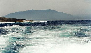
Barunguba / Montague Island is a continental island contained within the Montague Island Nature Reserve, a protected nature reserve that is located offshore from the South Coast region of New South Wales, in eastern Australia. The nearest town located onshore from the 81-hectare (200-acre) reserve and island is Narooma, situated approximately 9 kilometres (5.6 mi) to the northwest.

<span class="mw-page-title-main">Tilba, New South Wales</span> Town in New South Wales, Australia

Central Tilba and Tilba Tilba are two villages near the Princes Highway in Eurobodalla Shire, New South Wales, Australia. At the 2016 census, Central Tilba and surrounding areas had a population of 288.

<span class="mw-page-title-main">Bodalla, New South Wales</span> Town in New South Wales, Australia

Bodalla is a small town on the South Coast of New South Wales, Australia, and located in the local government area of Eurobodalla Shire. The town sits on the Princes Highway, and is connected by road to Moruya, Narooma, Nerrigundah, Eurobodalla and Potato Point.

<span class="mw-page-title-main">Bermagui, New South Wales</span> Town in New South Wales, Australia

Bermagui is a town on the south coast of New South Wales, Australia in the Bega Valley Shire. It lies on the shores of the southern end of Horseshoe Bay. The name is derived from the Dyirringanj word, permageua, possibly meaning "canoe with paddles".

<span class="mw-page-title-main">Yuin</span> Aboriginal Australian people of New South Wales

The Yuin nation, also spelt Djuwin, is a group of Australian Aboriginal peoples from the South Coast of New South Wales. All Yuin people share ancestors who spoke, as their first language, one or more of the Yuin language dialects. Sub-groupings of the Yuin people are made on the basis of language and other cultural features; groups include the Brinja or Brinja-Yuin, Budawang, Murramarang, Yuin-Monaro, Djiringanj, Walbunja, and more. They had a close association with the Thaua people.

<span class="mw-page-title-main">Gulaga / Mount Dromedary</span> Mountain in New South Wales, Australia

Gulaga, dual-named as Mount Dromedary and also referred to as Mount Gulaga, is a mountain located in the south coast region of New South Wales, Australia. It rises above the village of Central Tilba and is within the Gulaga National Park. At its highest point, it measures 806 metres (2,644 ft) above sea level.

<span class="mw-page-title-main">South Coast (New South Wales)</span> Region in New South Wales, Australia

The South Coast refers to the narrow coastal belt from the Shoalhaven district in the north to the state border with Victoria in the south in the south-eastern part of the State of New South Wales, Australia. It is bordered to the west by the coastal escarpment of the Southern Tablelands, and is largely covered by a series of national parks, namely Jervis Bay National Park, Eurobodalla National Park, and Beowa National Park. To the east is the coastline of the Pacific Ocean, which is characterised by rolling farmlands, small towns and villages along a rocky coastline, interspersed by numerous beaches and lakes.

<span class="mw-page-title-main">Mystery Bay, New South Wales</span> Town in New South Wales, Australia

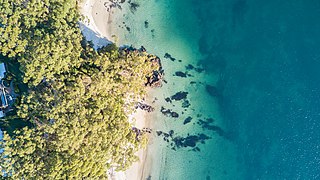
Mystery Bay is a small town on the south coast of New South Wales, Australia. Mystery Bay is halfway between Central Tilba and Narooma, two kilometres off the Princes Highway on Mystery Bay Road. At the 2016 census, Mystery Bay had a population of 191. Mystery Bay features a camping area in the Eurobodalla National Park. This park is known for its recreational activities and various species of Bird. Montague Island is close to Mystery Bay and is known for its unusual quantities of Penguin called Eudyptula minor and fur seals. There is also an Infestation of a specific type of House mouse called Mus musculus which has needed eradication because of its damage on the ecosystem.

<span class="mw-page-title-main">Wallaga Lake</span> Lake in New South Wales, Australia

Wallaga Lake is an estuarine lake in Bega Valley Shire in New South Wales, Australia, the largest lake in southern NSW. It is located between Bermagui to the south and between Tilba Tilba to the north, situated beneath Mount Gulaga, in the traditional lands of the Yuin people. A large section of its foreshore and catchment are within the Gulaga National Park, since Wallaga Lake National Park, Goura Nature Reserve, and Mt Dromedary Flora Reserve were combined into the larger national park. There is an island in the lake known as Merriman's Island, Merriman Island or Umbarra.

<span class="mw-page-title-main">Montague Island Light</span> Lighthouse in New South Wales, Australia

The Montague Island Light is a heritage-listed active lighthouse located on Barunguba / Montague Island, an island in the Tasman Sea, 9 kilometres (5.6 mi) offshore from Narooma on the south coast of New South Wales, Australia. The lighthouse is located at the highest point of the island. It was designed by James Barnet and NSW Colonial Architect and built from 1878 to 1881 by J. Musson and completed By W. H. Jennings. It is also known as the Montague Island Lightstation and its setting. The property is owned by the Office of Environment and Heritage, an agency of the Government of New South Wales. It was added to the New South Wales State Heritage Register on 2 April 1999, and the Commonwealth Heritage List on 22 June 2004.

The Dhurga language, also written Thurga, is an Australian Aboriginal language of New South Wales. It is a language of the Yuin people, specifically the Wandandian and Walbunja groups, but there have been no fluent speakers officially recorded for decades, so it has been functionally extinct for some time. Efforts have been made to revive the language since the 2010s.

<span class="mw-page-title-main">Batemans Bay (bay)</span> Bay in South Coast, New South Wales

Batemans Bay is an open oceanic embayment that is located in the South Coast region of New South Wales, Australia. The bay forms the mouth of the Clyde River and its primary outflow is to the Tasman Sea of the South Pacific Ocean.

Congo is a village in Eurobodalla Shire on the South Coast of New South Wales. Congo is located 315 km south of Sydney, and 10 km south of Moruya.

The Walbunja, also spelt Walbanga and Walbunga, are an Aboriginal Australian people of New South Wales, part of the Yuin nation.

References

  1. 1 2 Australian Bureau of Statistics (27 June 2017). "Narooma (Urban Centre)". 2016 Census QuickStats. Retrieved 3 December 2017. OOjs UI icon edit-ltr-progressive.svg
  2. "www.lovenarooma.com". Driving distances. Elise International Research. 2015. Archived from the original on 18 May 2015. Retrieved 10 May 2015.
  3. Horton, David R. (1996). "Map of Indigenous Australia". AIATSIS . Retrieved 19 August 2021.
  4. "Our Culture and Heritage". Wagonga Local Aboriginal Land Council. Retrieved 20 August 2021.
  5. 1 2 3 4 "Narooma, NSW". Aussie Towns. Retrieved 19 August 2021.
  6. Verass, Sophie. "Indigenous meanings of Australian town names". NITV . Retrieved 20 August 2021.
  7. S53 Dhurga at the Australian Indigenous Languages Database, Australian Institute of Aboriginal and Torres Strait Islander Studies
  8. 1 2 3 4 "Narooma". Walkabout. John Fairfax. Archived from the original on 23 March 2006. Retrieved 30 January 2006.
  9. "Concluding - The Development of Prince's Highway - South Coast Times and Wollongong Argus (NSW : 1900 - 1954) - 11 Jun 1951". Trove. Retrieved 25 August 2016.
  10. 1 2 "Narooma Bridge". Heritage and conservation register. Roads and Traffic Authority of New South Wales. 2002. Retrieved 30 January 2006.
  11. "Victoria Creek Bridge", Roads and Traffic Authority (NSW), 30 March 2004.
  12. Maritime heritage online - South east, Heritage Office NSW, 2001.
  13. "Montague Island". Eurobodalla Tourism. Retrieved 8 June 2016.
  14. "Australia Rock - Narooma Chamber". 2 July 2020. Retrieved 30 September 2021.
  15. "Narooma Golf Course". The Great Outdoors . au.travel.yahoo.com. December 2004. Retrieved 13 April 2008.
  16. "Great Southern Blues Fest To Return In 2016 As New Event". TheMusic.com.au. 17 November 2015. Retrieved 8 June 2016.
  17. Sharples, J.J. Mills, G.A., McRae, R.H.D., Weber, R.O. (2010) Elevated fire danger conditions associated with foehn-like winds in southeastern Australia. Journal of Applied Meteorology and Climatology.
  18. Rainforest In Southern New South Wales by the University of New England. Retrieved August 11, 2023.
  19. Narooma Paradise by VisitNSW.com, Destination NSW. Retrieved August 11, 2023.
  20. "Narooma (Marine Rescue) 1991–2020 averages". Bureau of Meteorology. Retrieved 31 October 2021.
  21. "Narooma (Marine Rescue) all years". Bureau of Meteorology. Retrieved 31 October 2021.

Commons-logo.svg Media related to Narooma, New South Wales at Wikimedia Commons