National Register of Historic Places listings in Belmont County, Ohio

Last updated

Location of Belmont County in Ohio Map of Ohio highlighting Belmont County.svg
Location of Belmont County in Ohio

This is a list of the National Register of Historic Places listings in Belmont County, Ohio.

Contents

This is intended to be a complete list of the properties and districts on the National Register of Historic Places in Belmont County, Ohio, United States. The locations of National Register properties and districts for which the latitude and longitude coordinates are included below, may be seen in an online map. [1]

There are 27 properties and districts listed on the National Register in the county, including 1 National Historic Landmark. Another property was once listed but has been removed.


    This National Park Service list is complete through NPS recent listings posted March 1, 2024. [2]

Current listings

[3] Name on the Register [4] ImageDate listed [5] Location City or townDescription
1 B & O Railroad Viaduct
B & O Railroad Viaduct Bellaire viaduct 02.jpg
B & O Railroad Viaduct
June 22, 1976
(#76001370)
31st St.
40°00′47″N80°44′40″W / 40.013056°N 80.744444°W / 40.013056; -80.744444 (B & O Railroad Viaduct)
Bellaire Extends into Benwood in Marshall County, West Virginia
2 Barnesville Baltimore and Ohio Railroad Depot
Barnesville Baltimore and Ohio Railroad Depot Barnesville Ohio Railroad Depot.jpg
Barnesville Baltimore and Ohio Railroad Depot
August 8, 1985
(#85001694)
300 E. Church St.
39°59′19″N81°10′24″W / 39.988611°N 81.173333°W / 39.988611; -81.173333 (Barnesville Baltimore and Ohio Railroad Depot)
Barnesville
3 Barnesville Historic District
Barnesville Historic District Downtown view east.jpg
Barnesville Historic District
July 19, 1984
(#84002899)
Roughly bounded by Arch, Main, Gardner, Chestnut, Bond, and Cherry Sts.
39°59′16″N81°10′38″W / 39.987778°N 81.177361°W / 39.987778; -81.177361 (Barnesville Historic District)
Barnesville
4 Barnesville Petroglyph
Barnesville Petroglyph Tracks at Barnesville Petroglyph.JPG
Barnesville Petroglyph
July 15, 1974
(#74001400)
Off Track Rocks Road, southwest of Barnesville [6]
39°58′45″N81°13′54″W / 39.979167°N 81.231667°W / 39.979167; -81.231667 (Barnesville Petroglyph)
Warren Township
5 Belleview Heights
Belleview Heights Belleview Heights.jpg
Belleview Heights
April 8, 1994
(#94000259)
65100 Candlewick Ln.
40°01′41″N80°44′37″W / 40.028056°N 80.743611°W / 40.028056; -80.743611 (Belleview Heights)
Bellaire
6 Belmont Historic District
Belmont Historic District Belmont Ohio Historic District.jpg
Belmont Historic District
March 13, 1987
(#87000422)
Roughly bounded by Barrister, John, Jefferson, Sycamore, and Bridge Sts.
40°01′46″N81°02′25″W / 40.029444°N 81.040139°W / 40.029444; -81.040139 (Belmont Historic District)
Belmont
7 Blaine Hill "S" Bridge
Blaine Hill "S" Bridge Blaine Hill S Bridge Ohio.jpg
Blaine Hill "S" Bridge
March 17, 2010
(#10000082)
Township Road 649 at Blaine
40°04′01″N80°49′15″W / 40.066922°N 80.820969°W / 40.066922; -80.820969 (Blaine Hill "S" Bridge)
Pease Township 385-foot-long (117 m) bridge with three stone arches; built in 1828; oldest standing bridge in Ohio [7]
8 Brick Tavern House
Brick Tavern House Brick Tavern House in Belmont County Ohio.JPG
Brick Tavern House
November 22, 1995
(#95001330)
U.S. Route 40 west of St. Clairsville
40°04′25″N80°58′58″W / 40.073611°N 80.982778°W / 40.073611; -80.982778 (Brick Tavern House)
Richland Township
9 Brokaw Site
Brokaw Site Brokaw Site.jpg
Brokaw Site
June 17, 1976
(#76001371)
Off Brokaw Dr., southwest of St. Clairsville [8]
40°04′04″N80°55′56″W / 40.067778°N 80.932222°W / 40.067778; -80.932222 (Brokaw Site)
Richland Township
10 Concord Hicksite Friends Meeting House
Concord Hicksite Friends Meeting House Concord Hicksite Friends Meetinghouse.jpg
Concord Hicksite Friends Meeting House
July 23, 2009
(#09000562)
Negus Rd.
40°07′31″N80°47′45″W / 40.12517°N 80.79576°W / 40.12517; -80.79576 (Concord Hicksite Friends Meeting House)
Colerain Township
11 DONALD B (towboat)
DONALD B (towboat) Donald B.jpg
DONALD B (towboat)
December 20, 1989
(#89002458)
Ohio River [9]
40°01′16″N80°44′17″W / 40.021111°N 80.738056°W / 40.021111; -80.738056 (DONALD B (towboat))
Bellaire
12 Finney-Darrah House
Finney-Darrah House Driveway view of Finley-Darrah House.jpg
Finney-Darrah House
March 15, 1982
(#82003546)
Scenery Hill
40°06′02″N80°44′22″W / 40.100556°N 80.739444°W / 40.100556; -80.739444 (Finney-Darrah House)
Martins Ferry
13 Friends Boarding School and Ohio Yearly Meetinghouse Historic District
Friends Boarding School and Ohio Yearly Meetinghouse Historic District Olney campus aerial sRGB.jpg
Friends Boarding School and Ohio Yearly Meetinghouse Historic District
March 25, 2009
(#09000168)
61830 Sandy Ridge Rd., east of Barnesville
39°59′18″N81°09′09″W / 39.988222°N 81.152386°W / 39.988222; -81.152386 (Friends Boarding School and Ohio Yearly Meetinghouse Historic District)
Warren Township
14 Thomas T. and Wesley B. Frasier Houses
Thomas T. and Wesley B. Frasier Houses Frasier Houses in Bridgeport Ohio.jpg
Thomas T. and Wesley B. Frasier Houses
November 17, 1982
(#82001359)
898 and 920 National Rd.
40°04′15″N80°45′35″W / 40.070833°N 80.759722°W / 40.070833; -80.759722 (Thomas T. and Wesley B. Frasier Houses)
Brookside
15 George-Caldwell-Grum Farm
George-Caldwell-Grum Farm GEORGE-CALDWELL-GRUM FARM, BELMONT COUNTY, OHIO.jpg
George-Caldwell-Grum Farm
February 14, 2018
(#100002118)
Address Restricted
Richland Township
16 Great Western Schoolhouse
Great Western Schoolhouse The GWS St C Ohio.jpg
Great Western Schoolhouse
May 7, 1979
(#79001787)
West of St. Clairsville on U.S. Route 40
40°04′22″N80°58′52″W / 40.072778°N 80.981111°W / 40.072778; -80.981111 (Great Western Schoolhouse)
Richland Township
17 Imperial Glass Company
Imperial Glass Company Imperial glass.jpg
Imperial Glass Company
September 8, 1983
(#83001945)
29th and Belmont Sts.
40°00′41″N80°44′49″W / 40.011389°N 80.746944°W / 40.011389; -80.746944 (Imperial Glass Company)
Bellaire
18 James Kinney Farmstead
James Kinney Farmstead James Kinney Home.JPG
James Kinney Farmstead
April 29, 1999
(#99000510)
44680 Belmont-Centerville Rd., southeast of Belmont
39°59′50″N80°59′38″W / 39.997222°N 80.99375°W / 39.997222; -80.99375 (James Kinney Farmstead)
Smith Township
19 Joseph Kirkwood House
Joseph Kirkwood House Joseph kirkwood house.jpg
Joseph Kirkwood House
February 13, 1986
(#86000239)
329 Bennett St.
40°04′08″N80°44′39″W / 40.068889°N 80.744167°W / 40.068889; -80.744167 (Joseph Kirkwood House)
Bridgeport
20 Morristown Historic District
Morristown Historic District Morristown Historic District.jpg
Morristown Historic District
March 6, 1980
(#80002943)
Church, Main, W. Cross, E. Cross, and Middle Cross Sts.
40°03′51″N81°04′22″W / 40.064167°N 81.072778°W / 40.064167; -81.072778 (Morristown Historic District)
Morristown
21 Opatrny Village Site
Opatrny Village Site East from Vineyard Road at Opatrny.jpg
Opatrny Village Site
May 21, 1975
(#75001323)
U.S. Route 40 north of the Belmont Hills Country Club [10]
40°04′29″N80°56′36″W / 40.074722°N 80.943333°W / 40.074722; -80.943333 (Opatrny Village Site)
Richland Township
22 Rock Hill Presbyterian Church
Rock Hill Presbyterian Church Rhpc.jpg
Rock Hill Presbyterian Church
April 1, 2009
(#09000169)
56244 High Ridge Rd., northwest of Bellaire
40°02′15″N80°46′22″W / 40.037563°N 80.772892°W / 40.037563; -80.772892 (Rock Hill Presbyterian Church)
Pultney Township
23 St. Clairsville Historic District
St. Clairsville Historic District Downtown St Clairsville Ohio.JPG
St. Clairsville Historic District
March 17, 1994
(#94000246)
E. and W. Main St. between Butler and Sugar Sts.
40°04′50″N80°54′02″W / 40.080556°N 80.900556°W / 40.080556; -80.900556 (St. Clairsville Historic District)
St. Clairsville
24 Dr. Lindley Schooley House and Office
Dr. Lindley Schooley House and Office Lindley Schooley House -- Belmont, Ohio.jpg
Dr. Lindley Schooley House and Office
April 1, 1982
(#82003545)
Main St.
40°01′45″N81°02′31″W / 40.029167°N 81.041944°W / 40.029167; -81.041944 (Dr. Lindley Schooley House and Office)
Belmont
25 Tower Site
Tower Site Tower Site Belmont Ohio.jpg
Tower Site
June 11, 1982
(#82003544)
On a hilltop 4 miles northwest of Barnesville [11]
40°01′23″N81°13′16″W / 40.0231°N 81.2211°W / 40.0231; -81.2211 (Tower Site)
Warren Township
26 Wheeling Island Historic District
Wheeling Island Historic District Aetnaville Bridge.jpg
Wheeling Island Historic District
April 2, 1992
(#92000320)
Roughly bounded by Stone, Front, North, Ontario, Erie, and Wabash Sts.
40°04′50″N80°44′15″W / 40.080556°N 80.737500°W / 40.080556; -80.737500 (Wheeling Island Historic District)
Bridgeport Primarily located in Ohio County, West Virginia, but includes the Aetnaville Bridge, which is partially in Ohio
27 Zweig Building
Zweig Building Zweig building.jpg
Zweig Building
January 28, 2000
(#00000018)
3396 Belmont St.
40°01′07″N80°44′32″W / 40.018611°N 80.742222°W / 40.018611; -80.742222 (Zweig Building)
Bellaire

Former listing

[3] Name on the RegisterImageDate listedDate removedLocationCity or townDescription
1 Central School
Central School Central School Site.jpg
Central School
May 7, 1979
(#79001786)
February 21, 1980Junction of Hickory and S. 4th Streets
40°05′41″N80°43′31″W / 40.0948°N 80.7254°W / 40.0948; -80.7254 (Central School)
Martins Ferry Destroyed

See also

Related Research Articles

<span class="mw-page-title-main">National Register of Historic Places listings in Cuyahoga County, Ohio</span>

This is a list of the National Register of Historic Places listings in Cuyahoga County, Ohio.

<span class="mw-page-title-main">National Register of Historic Places listings in Franklin County, Ohio</span>

This is a list of the National Register of Historic Places listings in Franklin County, Ohio.

<span class="mw-page-title-main">National Register of Historic Places listings in Hamilton County, Ohio</span>

This is a list of the National Register of Historic Places listings in Hamilton County, Ohio.

<span class="mw-page-title-main">National Register of Historic Places listings in Delaware County, Ohio</span>

This is a list of the National Register of Historic Places listings in Delaware County, Ohio.

<span class="mw-page-title-main">National Register of Historic Places listings in Licking County, Ohio</span>

This is a list of the National Register of Historic Places listings in Licking County, Ohio.

<span class="mw-page-title-main">National Register of Historic Places listings in Warren County, Ohio</span>

This is a list of the National Register of Historic Places listings in Warren County, Ohio.

<span class="mw-page-title-main">National Register of Historic Places listings in Greene County, Ohio</span>

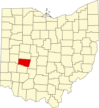
This is a list of the National Register of Historic Places listings in Greene County, Ohio.

<span class="mw-page-title-main">National Register of Historic Places listings in Muskingum County, Ohio</span>

This is a list of the National Register of Historic Places listings in Muskingum County, Ohio.

<span class="mw-page-title-main">National Register of Historic Places listings in Clark County, Ohio</span>

This is a list of the National Register of Historic Places listings in Clark County, Ohio.

<span class="mw-page-title-main">National Register of Historic Places listings in Ross County, Ohio</span>

This is a list of the National Register of Historic Places listings in Ross County, Ohio.

<span class="mw-page-title-main">National Register of Historic Places listings in Scioto County, Ohio</span>

This is a list of the National Register of Historic Places listings in Scioto County, Ohio.

<span class="mw-page-title-main">National Register of Historic Places listings in Athens County, Ohio</span>

This is a list of the National Register of Historic Places listings in Athens County, Ohio.

<span class="mw-page-title-main">National Register of Historic Places listings in Pickaway County, Ohio</span>

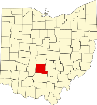
This is a list of the National Register of Historic Places listings in Pickaway County, Ohio, USA.

<span class="mw-page-title-main">National Register of Historic Places listings in Jefferson County, Ohio</span>

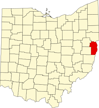
This is a list of the National Register of Historic Places listings in Jefferson County, Ohio.

<span class="mw-page-title-main">National Register of Historic Places listings in Adams County, Ohio</span>

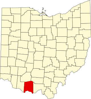
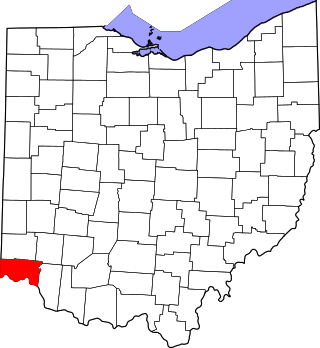
This is a list of the National Register of Historic Places listings in Adams County, Ohio.

<span class="mw-page-title-main">National Register of Historic Places listings in Hocking County, Ohio</span>

This is a list of the National Register of Historic Places listings in Hocking County, Ohio.

<span class="mw-page-title-main">National Register of Historic Places listings in Dearborn County, Indiana</span>

This is a list of the National Register of Historic Places listings in Dearborn County, Indiana.

<span class="mw-page-title-main">National Register of Historic Places listings in Monroe County, Ohio</span>

This is a list of the National Register of Historic Places listings in Monroe County, Ohio.

<span class="mw-page-title-main">National Register of Historic Places listings in Meigs County, Ohio</span>

This is a list of the National Register of Historic Places listings in Meigs County, Ohio.

<span class="mw-page-title-main">National Register of Historic Places listings in Pike County, Ohio</span>

This is a list of the National Register of Historic Places listings in Pike County, Ohio.

References

  1. The latitude and longitude information provided in this table was derived originally from the National Register Information System, which has been found to be fairly accurate for about 99% of listings. Some locations in this table may have been corrected to current GPS standards.
  2. National Park Service, United States Department of the Interior, "National Register of Historic Places: Weekly List Actions", retrieved March 1, 2024.
  3. 1 2 Numbers represent an alphabetical ordering by significant words. Various colorings, defined here, differentiate National Historic Landmarks and historic districts from other NRHP buildings, structures, sites or objects.
  4. "National Register Information System". National Register of Historic Places . National Park Service. April 24, 2008.
  5. The eight-digit number below each date is the number assigned to each location in the National Register Information System database, which can be viewed by clicking the number.
  6. Location derived from Swauger, James L. Rock Art of the Upper Ohio Valley. Graz: Akademische Druck- und Verlagsanstalt, 1974, 115. The NRIS lists the site as "Address Restricted".
  7. Wright, D.K. (May 18, 2010). "Old Blaine Hill S-Bridge Makes National Register of Historic Places". The State Journal . Charleston, West Virginia: West Virginia Media Holdings, LLC. Archived from the original on July 25, 2011. Retrieved May 18, 2010.
  8. Pickenpaugh, Thomas E. "The Brokaw Site (33-Bl-6) — A Preliminary Report". Ohio Archaeologist 24 (1974): 40.
  9. Location derived from previous owner's website; the NRIS still lists the boat in Brown County.
  10. Gray and Pape. National Road/U.S. 40 Historic Properties Inventory in Ohio Archived 2014-02-21 at the Wayback Machine , Vol. 1. Columbus: Ohio Department of Transportation, 1998-07-02, 65.
  11. Location derived from Brown, Jeffrey D. The Tower Site and Ohio Monongahela. Kent: Kent State U, 1981, 3. The NRIS lists the site as "Address Restricted".