National Register of Historic Places listings in Brookhaven (town), New York

Last updated

Map showing Brookhaven in New York and Suffolk County Suffolk County, NY, towns and villages Town of Brookhaven highlighted.svg
Map showing Brookhaven in New York and Suffolk County
Map all coordinates using: OpenStreetMap

This is a list of all National Register of Historic Places listings in the Town of Brookhaven, New York. The locations of National Register properties for which the latitude and longitude coordinates are included below, may be seen in an online map. [1]

Contents

Listings

[2] Name on the RegisterImageDate listed [3] Location City or townDescription
1 Bald Hill Schoolhouse
Bald Hill Schoolhouse Bald Hill Schoolhouse.JPG
Bald Hill Schoolhouse
July 21, 1988
(#88001018)
Horseblock Road
40°50′06″N73°02′34″W / 40.835°N 73.042778°W / 40.835; -73.042778 (Bald Hill Schoolhouse)
Farmingville
2 Bayles Shipyard
Bayles Shipyard Bayles Shipyard 1917 Machine Shop and Mould Loft Dec 07.jpg
Bayles Shipyard
June 2, 2000
(#00000580)
101 East Broadway
40°56′54″N73°04′05″W / 40.948333°N 73.068056°W / 40.948333; -73.068056 (Bayles Shipyard)
Port Jefferson
3 Mary E. Bell House
Mary E. Bell House Mary E. Bell House 2018.jpg
Mary E. Bell House
November 13, 2020
(#100005831)
66 Railroad Ave.
40°48′13″N72°47′24″W / 40.8035°N 72.7901°W / 40.8035; -72.7901 (Mary E. Bell House)
Center Moriches
4 Bellport Academy
Bellport Academy Bellport Academy.jpg
Bellport Academy
July 4, 1980
(#02001452)
24 Academy Lane
40°45′14″N72°56′16″W / 40.754008°N 72.937831°W / 40.754008; -72.937831 (Bellport Academy)
Bellport
5 Bellport Village Historic District
Bellport Village Historic District Bellport 4 Corners; Village Bistro.JPG
Bellport Village Historic District
July 4, 1980
(#02001451)
Roughly bounded by South Country Road, Bellport Lane, Brown's Lane, Brewster Lane, and Bell Street
40°45′30″N72°56′12″W / 40.758297°N 72.936794°W / 40.758297; -72.936794 (Bellport Village Historic District)
Bellport
6 Benner–Foos–Ceparano Estate
Benner-Foos-Ceparano Estate Benner-Foos-Ceparano Estate.jpg
Benner–Foos–Ceparano Estate
August 22, 2016
(#16000557)
99 Van Brunt Manor & 6 Osprey Lane
40°57′20″N73°05′39″W / 40.955619°N 73.094161°W / 40.955619; -73.094161 (Benner–Foos–Ceparano Estate)
Poquott Shingle Style 1890s estate is only Lamb & Rich design with bowed plan. Transitioned from vacation home to full-time residence over the 20th century; one of the few North Shore estates in its original form.
7 Bethel Christian Avenue Historic District
Bethel Christian Avenue Historic District Christian ave circa 1909.jpg
Bethel Christian Avenue Historic District
November 9, 2017
(#100001808)
Roughly Christian Ave., Hill & Locust Sts.
40°56′31″N73°07′21″W / 40.94207°N 73.12238°W / 40.94207; -73.12238 (Bethel Christian Avenue Historic District)
Setauket African-American neighborhood built around 19th-century church
8 Mary Louise Booth Girlhood House
Mary Louise Booth Girlhood House Mary Louise Booth Girlhood Home-2.JPG
Mary Louise Booth Girlhood House
January 27, 2015
(#14001219)
E. Main St.
40°50′12″N72°54′57″W / 40.8367°N 72.9157°W / 40.8367; -72.9157 (Mary Louise Booth Girlhood House)
Yaphank Childhood home of Mary Louise Booth, 19th-century newspaper editor and French translator. See these links, and this one too.
9 Brewster House
Brewster House Brewster House; East Setauket, NY.JPG
Brewster House
February 28, 2008
(#08000109)
Junction of NY 25A & Runs Road
40°56′43″N73°06′11″W / 40.945278°N 73.103056°W / 40.945278; -73.103056 (Brewster House)
East Setauket
10 Caroline Church and Cemetery
Caroline Church and Cemetery Caroline Church and Cemetery Nov 07.jpg
Caroline Church and Cemetery
September 9, 1991
(#91001148)
Junction of Dyke and Bates Roads
40°56′49″N73°06′46″W / 40.946944°N 73.112778°W / 40.946944; -73.112778 (Caroline Church and Cemetery)
Setauket
11 Carrington House
Carrington House Carrington House.png
Carrington House
January 8, 2014
(#13001057)
Lewis Walk (at eastern terminus of Ocean Walk)
40°39′43″N73°04′39″W / 40.661898°N 73.077606°W / 40.661898; -73.077606 (Carrington House)
Cherry Grove Early 20th-century beach bungalow was home to theater director Frank Carrington and an early center of gay life on Fire Island; Truman Capote wrote Breakfast at Tiffany's during a stay there.
12 Cherry Grove Community House and Theatre
Cherry Grove Community House and Theatre Cherry Grove House.png
Cherry Grove Community House and Theatre
June 4, 2013
(#13000373)
180 Bayview Walk
40°39′36″N73°05′26″W / 40.660072°N 73.090566°W / 40.660072; -73.090566 (Cherry Grove Community House and Theatre)
Cherry Grove
13 Congregational Church of Patchogue
Congregational Church of Patchogue Patchogue Congregational Church(Sign).jpg
Congregational Church of Patchogue
April 1, 1993
(#93000279)
95 East Main Street
40°45′57″N73°00′47″W / 40.765833°N 73.013056°W / 40.765833; -73.013056 (Congregational Church of Patchogue)
Patchogue
14 Davis Town Meeting House
Davis Town Meeting House Davis Town Meeting House.jpg
Davis Town Meeting House
August 15, 2001
(#01000850)
Junction of Middle Country Road and Coram-Mt. Sinai Road
40°52′54″N72°59′01″W / 40.881667°N 72.983611°W / 40.881667; -72.983611 (Davis Town Meeting House)
Coram
15 ELVIRA (sloop) May 23, 2012
(#12000288)
Newey Lane
40°46′17″N72°53′54″W / 40.771292°N 72.898284°W / 40.771292; -72.898284 (ELVIRA (sloop))
Brookhaven
16 First Congregational Church of New Village
First Congregational Church of New Village First Congregational Church, Centereach, Suffolk County, NY HABS NY,52-CEN,1-1.tif
First Congregational Church of New Village
April 11, 2002
(#02000361)
North side of Middle Country Road, West of Elliot Avenue
40°51′35″N73°06′37″W / 40.859722°N 73.110278°W / 40.859722; -73.110278 (First Congregational Church of New Village)
Lake Grove
17 First National Bank of Port Jefferson
First National Bank of Port Jefferson Port Jefferson 1st National Bank.jpg
First National Bank of Port Jefferson
October 5, 2005
(#05001134)
Main and East Main Streets
40°56′43″N73°04′06″W / 40.945278°N 73.068333°W / 40.945278; -73.068333 (First National Bank of Port Jefferson)
Port Jefferson
18 William Floyd House
William Floyd House WilliamFloydEstate.jpg
William Floyd House
October 15, 1980
(#71000066)
20 Washington Avenue
40°46′09″N72°49′21″W / 40.7692°N 72.8225°W / 40.7692; -72.8225 (William Floyd House)
Mastic Beach Owned and operated by the National Park Service and is a part of Fire Island National Seashore.
19 Gamecock Cottage
Gamecock Cottage Gamecock Cottage.JPG
Gamecock Cottage
August 30, 2007
(#07000886)
Shipman's Point, South end of West Meadow Beach
40°55′40″N73°08′50″W / 40.927778°N 73.147222°W / 40.927778; -73.147222 (Gamecock Cottage)
Stony Brook
20 Noah Hallock House
Noah Hallock House Noah Hallock Homestead; Rocky Point-1.JPG
Noah Hallock House
December 11, 2013
(#13000913)
172 Hallock Landing Road
40°57′43″N72°56′19″W / 40.961954°N 72.938476°W / 40.961954; -72.938476 (Noah Hallock House)
Rocky Point Seaside frame cottage of early settler
21 Hawkins Homestead
Hawkins Homestead Zachariah Hawkins Homestead-2.JPG
Hawkins Homestead
June 9, 1988
(#88000727)
165 Christian Avenue
40°55′45″N73°08′19″W / 40.929167°N 73.138611°W / 40.929167; -73.138611 (Hawkins Homestead)
Stony Brook
22 Robert Hawkins Homestead
Robert Hawkins Homestead Robert Hawkins Homestead; Yaphank.JPG
Robert Hawkins Homestead
April 10, 1986
(#86000702)
Yaphank Avenue
40°49′04″N72°55′04″W / 40.817778°N 72.917778°W / 40.817778; -72.917778 (Robert Hawkins Homestead)
Yaphank
23 Homan-Gerard House and Mills
Homan-Gerard House and Mills Homan-Gerard House & Mills - John Homan House.JPG
Homan-Gerard House and Mills
December 16, 1988
(#88002761)
Junction Main Street and Yaphank Road
40°50′09″N72°54′57″W / 40.835833°N 72.915833°W / 40.835833; -72.915833 (Homan-Gerard House and Mills)
Yaphank
24 Samuel Hopkins House
Samuel Hopkins House Samuel Hopkins House.jpg
Samuel Hopkins House
February 26, 2009
(#09000057)
415 Pipe Stave Hollow Road
40°57′30″N73°01′16″W / 40.958272°N 73.021003°W / 40.958272; -73.021003 (Samuel Hopkins House)
Miller Place
25 Nathaniel Longbotham House
Nathaniel Longbotham House Nathaniel Longbotham House, original structure.jpg
Nathaniel Longbotham House
November 16, 1989
(#89002022)
1541 Stony Brook Road
40°54′27″N73°08′05″W / 40.9075°N 73.134722°W / 40.9075; -73.134722 (Nathaniel Longbotham House)
Stony Brook
26 Masury Estate Ballroom
Masury Estate Ballroom Masury Estate Ballroom-3.JPG
Masury Estate Ballroom
September 11, 1986
(#86002513)
Old Neck Road South
40°46′54″N72°48′26″W / 40.781667°N 72.807222°W / 40.781667; -72.807222 (Masury Estate Ballroom)
Center Moriches
27 Frank Melville Memorial Park
Frank Melville Memorial Park Setauketmillpond.JPG
Frank Melville Memorial Park
July 19, 2010
(#10000486)
Old Field Road between Lake Street and Main Street
40°56′42″N73°06′57″W / 40.945°N 73.115833°W / 40.945; -73.115833 (Frank Melville Memorial Park)
Setauket
28 Middle Island Presbyterian Church
Middle Island Presbyterian Church Middle Island Presbyterian Church.JPG
Middle Island Presbyterian Church
December 7, 2005
(#05001388)
271 Middle Country Road
40°52′49″N72°57′48″W / 40.880278°N 72.963333°W / 40.880278; -72.963333 (Middle Island Presbyterian Church)
Middle Island
29 Miller Place Historic District
Miller Place Historic District MPacademy2.jpg
Miller Place Historic District
June 17, 1976
(#76001281)
North Country Road
40°57′30″N72°59′56″W / 40.958333°N 72.998889°W / 40.958333; -72.998889 (Miller Place Historic District)
Miller Place
30 William Sidney Mount House
William Sidney Mount House William-sydney-mount-house.jpg
William Sidney Mount House
October 15, 1966
(#66000575)
Stony Brook Road and NY 25A
40°54′27″N73°08′18″W / 40.9075°N 73.138333°W / 40.9075; -73.138333 (William Sidney Mount House)
Stony Brook
31 Old Bethel Cemetery
Old Bethel Cemetery Bethel AME Church Cemetery Interior.jpg
Old Bethel Cemetery
November 9, 2017
(#100001810)
Christian & Woodfield Avenues
40°55′54″N73°07′59″W / 40.93157°N 73.13307°W / 40.93157; -73.13307 (Old Bethel Cemetery)
Stony Brook Final resting place of many early residents of the Bethel Christian Avenue Historic District
32 Old Field Club and Farm
Old Field Club and Farm Old Field Club 1.jpg
Old Field Club and Farm
February 2, 2016
(#15001027)
86 West Meadow Road
40°56′49″N73°08′22″W / 40.946912°N 73.139524°W / 40.946912; -73.139524 (Old Field Club and Farm)
East Setauket Early social center of Setauket when built for a residential community in 1930
33 Old Field Point Light Station
Old Field Point Light Station Old Field Point Light.jpg
Old Field Point Light Station
January 25, 2024
(#100009784)
207 Old Field Road
40°58′37″N73°07′07″W / 40.977°N 73.1186°W / 40.977; -73.1186 (Old Field Point Light Station)
Setauket
33 Point O'Woods Historic District July 29, 2021
(#100006763)
Point O'Woods, Bay, and Ridge Aves., Church St.
40°39′04″N73°07′58″W / 40.6511°N 73.1328°W / 40.6511; -73.1328 (Point O'Woods Historic District)
Point O' Woods
34 Port Jefferson Village Historic District
Port Jefferson Village Historic District Port Jefferson Village Historic District Dec 07.jpg
Port Jefferson Village Historic District
April 6, 2005
(#05000265)
Roughly along East Main Street, East Broadway, Grant Street, High Street and South Street
40°56′49″N73°03′58″W / 40.946944°N 73.066111°W / 40.946944; -73.066111 (Port Jefferson Village Historic District)
Port Jefferson
35 Setauket Presbyterian Church and Burial Ground
Setauket Presbyterian Church and Burial Ground Setauket Presbyterian Church.jpg
Setauket Presbyterian Church and Burial Ground
September 27, 1996
(#96001023)
5 Caroline Avenue
40°56′45″N73°06′41″W / 40.945833°N 73.111389°W / 40.945833; -73.111389 (Setauket Presbyterian Church and Burial Ground)
Setauket
36 Sherwood-Jayne House
Sherwood-Jayne House Sherwood-Jayne House; East Setauket-2.JPG
Sherwood-Jayne House
December 2, 2009
(#09000969)
55 Old Post Road
40°56′21″N73°05′20″W / 40.939267°N 73.088786°W / 40.939267; -73.088786 (Sherwood-Jayne House)
East Setauket
37 Smith Estate
Smith Estate Longwood Smith Estate.JPG
Smith Estate
December 10, 1981
(#81000414)
Longwood and Smith Roads
40°52′05″N72°54′24″W / 40.868056°N 72.906667°W / 40.868056; -72.906667 (Smith Estate)
Ridge Also known as Longwood Estate - Smith House [4]
38 Smith-Rourke House
Smith-Rourke House Smith-Rourke House; East Patchogue, NY.JPG
Smith-Rourke House
November 28, 1989
(#89002021)
350 South Country Road
40°45′43″N72°58′44″W / 40.761944°N 72.978889°W / 40.761944; -72.978889 (Smith-Rourke House)
East Patchogue
39 St. Andrew's Episcopal Church
St. Andrew's Episcopal Church Yaphank St Andrew's Episcopal Church.jpg
St. Andrew's Episcopal Church
September 15, 1988
(#88001442)
Main Street
40°50′12″N72°54′55″W / 40.836667°N 72.915278°W / 40.836667; -72.915278 (St. Andrew's Episcopal Church)
Yaphank
40 St. James Chapel
St. James Chapel Stony Brook NY St James Chapel.JPG
St. James Chapel
June 16, 2000
(#00000583)
East side of Main Street, 250 ft. North of Stony Brook Lane
40°54′56″N73°08′50″W / 40.915556°N 73.147222°W / 40.915556; -73.147222 (St. James Chapel)
Stony Brook
41 St. Paul's Episcopal Church Complex
St. Paul's Episcopal Church Complex St. Paul's Episcopal Church Complex - Patchogue-1-.jpg
St. Paul's Episcopal Church Complex
June 22, 1995
(#95000722)
31 Rider Avenue
40°45′52″N73°00′33″W / 40.764444°N 73.009167°W / 40.764444; -73.009167 (St. Paul's Episcopal Church Complex)
Patchogue
42 Stony Brook Grist Mill
Stony Brook Grist Mill Stony Brook Grist Mill.jpg
Stony Brook Grist Mill
August 3, 1990
(#90001140)
Harbor Road, West of Main Street
40°54′49″N73°08′47″W / 40.913611°N 73.146389°W / 40.913611; -73.146389 (Stony Brook Grist Mill)
Stony Brook
43 Suffolk County Almshouse Barn
Suffolk County Almshouse Barn Suffolk County Almshouse Barn.JPG
Suffolk County Almshouse Barn
September 11, 1986
(#86002512)
West of Yaphank Avenue
40°49′41″N72°55′18″W / 40.828056°N 72.921667°W / 40.828056; -72.921667 (Suffolk County Almshouse Barn)
Yaphank
44 Swan River Schoolhouse
Swan River Schoolhouse Swan River School House; East Patchogue, New York-2.jpg
Swan River Schoolhouse
August 18, 2017
(#100001492)
31 Roe Avenue
40°45′52″N72°59′20″W / 40.764580°N 72.98877°W / 40.764580; -72.98877 (Swan River Schoolhouse)
East Patchogue
45 Terry-Ketcham Inn
Terry-Ketcham Inn Ketcham Inn.jpg
Terry-Ketcham Inn
June 24, 1993
(#92000555)
81 Main Street
40°48′08″N72°46′52″W / 40.802222°N 72.781111°W / 40.802222; -72.781111 (Terry-Ketcham Inn)
Center Moriches
46 Thompson House
Thompson House Setauket Thompson House.jpg
Thompson House
January 7, 1988
(#87002283)
North Country Road
40°56′01″N73°07′04″W / 40.933501°N 73.117779°W / 40.933501; -73.117779 (Thompson House)
Setauket
47 United Methodist Church
United Methodist Church United Methodist Church - Patchogue-2-.jpg
United Methodist Church
April 19, 1984
(#84003006)
South Ocean Avenue and Church Street
40°45′52″N73°00′53″W / 40.764439°N 73.014619°W / 40.764439; -73.014619 (United Methodist Church)
Patchogue
48 Union Savings Bank
Union Savings Bank Patchogue Union Savings Bank; Corner.JPG
Union Savings Bank
June 11, 2010
(#10000337)
62 South Ocean Avenue
40°45′52″N73°00′54″W / 40.764497°N 73.014972°W / 40.764497; -73.014972 (Union Savings Bank)
Patchogue On the opposite corner from United Methodist Church (Patchogue, New York)
49 US Post Office-Patchogue
US Post Office-Patchogue Patchogue Post Office.jpg
US Post Office-Patchogue
May 11, 1989
(#88002397)
170 East Main Street
40°45′55″N73°00′42″W / 40.765278°N 73.011667°W / 40.765278; -73.011667 (US Post Office-Patchogue)
Patchogue
50 USS SAN DIEGO (Armored Cruiser) Shipwreck Site
USS SAN DIEGO (Armored Cruiser) Shipwreck Site Uss california ca.jpg
USS SAN DIEGO (Armored Cruiser) Shipwreck Site
February 17, 1998
(#98000071)
Address Restricted
Fire Island
51 Wardenclyffe Laboratories
Wardenclyffe Laboratories Ward-tower-today.jpg
Wardenclyffe Laboratories
July 27, 2018
(#100002744)
56 NY 25A
40°56′54″N72°53′54″W / 40.9484°N 72.8984°W / 40.9484; -72.8984 (Wardenclyffe Laboratories)
Shoreham Ruins of laboratory designed by Stanford White for Nicola Tesla's early telecommunications research in 1901
52 Josiah Woodhull House
Josiah Woodhull House Josiah Woodhull House.JPG
Josiah Woodhull House
August 24, 2011
(#11000602)
170 North Country Rd.
40°57′30″N72°52′12″W / 40.958333°N 72.87°W / 40.958333; -72.87 (Josiah Woodhull House)
Shoreham

Former listings

[2] Name on the RegisterImageDate listedDate removedLocationCity or townDescription
1 Radio Central Complex
Radio Central Complex Proposed RCA Radio Central facility at Rocky Point, Long Island, New York.jpg
Radio Central Complex
June 27, 1980
(#80002777)
April 25, 1997S of Rocky Point on Rocky Point-Yaphank Rd.
Rocky Point vicinityCurrently owned by the New York State Department of Environmental Conservation. See this link also.
2 West Meadow Beach Historic District
West Meadow Beach Historic District WestMeadowBeach 02.jpg
West Meadow Beach Historic District
October 28, 2004
(#04001195)
June 24, 2022Trustees Road
40°55′59″N73°08′48″W / 40.933056°N 73.146667°W / 40.933056; -73.146667 (West Meadow Beach Historic District)
Stony Brook

See also

Related Research Articles

<span class="mw-page-title-main">National Register of Historic Places listings in Chautauqua County, New York</span>

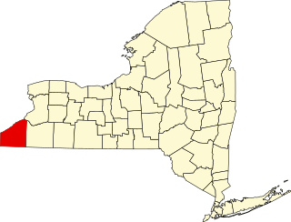
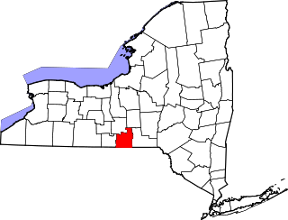
This is a list of the National Register of Historic Places listings in Chautauqua County, New York.

<span class="mw-page-title-main">National Register of Historic Places listings in Fulton County, New York</span>

List of the National Register of Historic Places listings in Fulton County, New York

<span class="mw-page-title-main">National Register of Historic Places listings in Genesee County, New York</span>

List of the National Register of Historic Places listings in Genesee County, New York

<span class="mw-page-title-main">National Register of Historic Places listings in Jefferson County, New York</span>

List of the National Register of Historic Places listings in Jefferson County, New York

<span class="mw-page-title-main">National Register of Historic Places listings in Lewis County, New York</span>

List of the National Register of Historic Places listings in Lewis County, New York

<span class="mw-page-title-main">National Register of Historic Places listings in Livingston County, New York</span>

List of the National Register of Historic Places listings in Livingston County, New York

<span class="mw-page-title-main">National Register of Historic Places listings in Ontario County, New York</span>

List of the National Register of Historic Places listings in Ontario County, New York

<span class="mw-page-title-main">National Register of Historic Places listings in Oswego County, New York</span>

List of the National Register of Historic Places listings in Oswego County, New York

<span class="mw-page-title-main">National Register of Historic Places listings in Putnam County, New York</span>

List of the National Register of Historic Places listings in Putnam County, New York

<span class="mw-page-title-main">National Register of Historic Places listings in Schuyler County, New York</span>

List of the National Register of Historic Places listings in Schuyler County, New York

<span class="mw-page-title-main">National Register of Historic Places listings in Steuben County, New York</span>

List of the National Register of Historic Places listings in Steuben County, New York

<span class="mw-page-title-main">National Register of Historic Places listings in Yates County, New York</span>

List of the National Register of Historic Places listings in Yates County, New York

<span class="mw-page-title-main">National Register of Historic Places listings in Wyoming County, New York</span>

List of the National Register of Historic Places listings in Wyoming County, New York

<span class="mw-page-title-main">National Register of Historic Places listings in Wayne County, New York</span>

List of the National Register of Historic Places listings in Wayne County, New York

<span class="mw-page-title-main">National Register of Historic Places listings in Washington County, New York</span>

List of the National Register of Historic Places listings in Washington County, New York

<span class="mw-page-title-main">National Register of Historic Places listings in Tompkins County, New York</span>

List of the National Register of Historic Places listings in Tompkins County, New York

<span class="mw-page-title-main">National Register of Historic Places listings in Tioga County, New York</span>

List of the National Register of Historic Places listings in Tioga County, New York

<span class="mw-page-title-main">National Register of Historic Places listings in Madison County, New York</span>

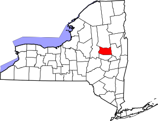
List of the National Register of Historic Places listings in Madison County, New York

This is intended to be a complete list of properties and districts listed on the National Register of Historic Places on Manhattan Island below 14th Street, which is a significant portion of the New York City borough of Manhattan. In turn, the borough of Manhattan is coterminous with New York County, New York. For properties and districts in other parts of Manhattan Island, the mainland neighborhood of Marble Hill, and the other islands of New York County, see National Register of Historic Places listings in Manhattan. The locations of National Register properties and districts may be seen in an online map by clicking on "Map of all coordinates".

This is a list of the National Register of Historic Places entries in New Rochelle, New York. See also National Register of Historic Places listings in Westchester County, New York for all others in the county.

References

  1. The latitude and longitude information provided is primarily from the National Register Information System, and has been found to be fairly accurate for about 99% of listings. For 1%, the location info may be way off. We seek to correct the coordinate information wherever it is found to be erroneous. Please leave a note in the Discussion page for this article if you believe any specific location is incorrect.
  2. 1 2 Numbers represent an alphabetical ordering by significant words. Various colorings, defined here, differentiate National Historic Landmarks and historic districts from other NRHP buildings, structures, sites or objects.
  3. The eight-digit number below each date is the number assigned to each location in the National Register Information System database, which can be viewed by clicking the number.
  4. Longwood's Journey (Longwood Library History Website) Archived 2009-05-01 at the Wayback Machine