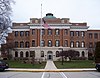
This is a list of the National Register of Historic Places listings in Dane County, Wisconsin. It aims to provide a comprehensive listing of buildings, sites, structures, districts, and objects in Dane County, Wisconsin listed on the National Register of Historic Places.

This is a list of the National Register of Historic Places listings in Winnebago County, Wisconsin.
This is a list of the National Register of Historic Places listings in Fond du Lac County, Wisconsin. It is intended to provide a comprehensive listing of entries in the National Register of Historic Places that are located in Fond du Lac County, Wisconsin. The locations of National Register properties for which the latitude and longitude coordinates are included below may be seen in a map.

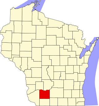
This is a list of the National Register of Historic Places listings in Grant County, Wisconsin. It is intended to provide a comprehensive listing of entries in the National Register of Historic Places that are located in Grant County, Wisconsin. The locations of National Register properties for which the latitude and longitude coordinates are included below may be seen in a map.
This is a list of the National Register of Historic Places listings in Iowa County, Wisconsin. It is intended to provide a comprehensive listing of entries in the National Register of Historic Places that are located in Iowa County, Wisconsin. The locations of National Register properties for which the latitude and longitude coordinates are included below may be seen in a map.

This is a list of the National Register of Historic Places listings in Ozaukee County, Wisconsin. It is intended to provide a comprehensive listing of entries in the National Register of Historic Places that are located in Ozaukee County, Wisconsin. The locations of National Register properties for which the latitude and longitude coordinates are included below may be seen in a map.

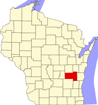
This is a list of the National Register of Historic Places listings in Sheboygan County, Wisconsin. It is intended to provide a comprehensive listing of entries in the National Register of Historic Places that are located in Sheboygan County, Wisconsin. The locations of National Register properties for which the latitude and longitude coordinates are included below may be seen in a map.

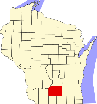
This is a list of the National Register of Historic Places listings in Dodge County, Wisconsin. It is intended to provide a comprehensive listing of entries in the National Register of Historic Places that are located in Dodge County, Wisconsin. The locations of National Register properties for which the latitude and longitude coordinates are included below may be seen in a map.

This is a list of the National Register of Historic Places listings in Washington County, Wisconsin. It is intended to provide a comprehensive listing of entries in the National Register of Historic Places that are located in Washington County, Wisconsin. The locations of National Register properties for which the latitude and longitude coordinates are included below may be seen in a map.
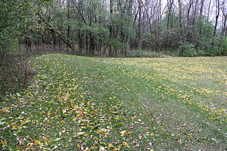
Calumet County Park Group is an archaeological site in Calumet County, Wisconsin, United States. It consists of six effigy mounds of panthers and other water spirits and it is located at the top of the Niagara Escarpment where overlook Lake Winnebago. The group is located within the Calumet County Park approximately 2 miles northwest of Stockbridge. The mounds are consistent with other mound groups found at the peak of the Niagara Escarpment along the eastern shore of Lake Winnebago, including the High Cliff Mounds. It was listed on the National Register of Historic Places in 1997.

The Stockbridge Indian Cemetery is a cemetery north of Stockbridge, Wisconsin. It is located on Moore Road just west of Wisconsin Highway 55. The cemetery was established in 1834 after the Stockbridge Indians moved to the community. It was listed on the National Register of Historic Places in 1980.

This is a list of the National Register of Historic Places listings in Manitowoc County, Wisconsin. It is intended to provide a comprehensive listing of entries in the National Register of Historic Places that are located in Manitowoc County, Wisconsin. The locations of National Register properties for which the latitude and longitude coordinates are included below may be seen in a map.

This is a list of the National Register of Historic Places listings in Portage County, Wisconsin. It is intended to provide a comprehensive listing of entries in the National Register of Historic Places that are located in Portage County, Wisconsin. The locations of National Register properties for which the latitude and longitude coordinates are included below may be seen in a map.

This is a list of the National Register of Historic Places listings in Waushara County, Wisconsin. It is intended to provide a comprehensive listing of entries in the National Register of Historic Places that are located in Waushara County, Wisconsin. The locations of National Register properties for which the latitude and longitude coordinates are included below may be seen in a map.

This is a list of the National Register of Historic Places listings in Vernon County, Wisconsin, USA. It is intended to provide a comprehensive listing of entries in the National Register of Historic Places that are located in Vernon County, Wisconsin. The locations of National Register properties for which the latitude and longitude coordinates are included below may be seen in a map.
This is a list of the National Register of Historic Places listings in Green Lake County, Wisconsin. It is intended to provide a comprehensive listing of entries in the National Register of Historic Places that are located in Green Lake County, Wisconsin. The locations of National Register properties for which the latitude and longitude coordinates are included below may be seen in a map.

This is a list of the National Register of Historic Places listings in Price County, Wisconsin. It is intended to provide a comprehensive listing of entries in the National Register of Historic Places that are located in Price County, Wisconsin. The locations of National Register properties for which the latitude and longitude coordinates are included below may be seen in a map.

This is a list of the National Register of Historic Places listings in Wood County, Wisconsin. It is intended to provide a comprehensive listing of entries in the National Register of Historic Places that are located in Wood County, Wisconsin. The locations of National Register properties for which the latitude and longitude coordinates are included below may be seen in a map.

This is a list of the National Register of Historic Places listings in Dunn County, Wisconsin. It is intended to provide a comprehensive listing of entries in the National Register of Historic Places that are located in Dunn County, Wisconsin. The locations of National Register properties for which the latitude and longitude coordinates are included below may be seen in a map.
The Haese Memorial Village Historic District is located in Forest Junction, Wisconsin.