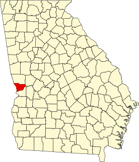
This is a list of properties and districts in Camden County, Georgia that are listed on the National Register of Historic Places (NRHP).
This National Park Service list is complete through NPS recent listings posted March 4, 2022. [1]
This is a list of properties and districts in Camden County, Georgia that are listed on the National Register of Historic Places (NRHP).
This National Park Service list is complete through NPS recent listings posted March 4, 2022. [1]
| [2] | Name on the Register | Image | Date listed [3] | Location | City or town | Description |
|---|---|---|---|---|---|---|
| 1 | Camden County Courthouse |  | September 18, 1980 (#80000983) | 4th and Camden Aves. 30°58′06″N81°43′14″W / 30.96820°N 81.72069°W | Woodbine | |
| 2 | Crooked River Site (9CAM118) |  | December 23, 1985 (#85003179) | Address Restricted. | St. Marys | Is in the extreme northeastern part of Crooked River State Park [4] |
| 3 | Duck House | February 13, 1984 (#84000938) | Cumberland Island 30°50′50″N81°25′51″W / 30.847222°N 81.430833°W | St. Marys | ||
| 4 | Dungeness Historic District |  | February 13, 1984 (#84000920) | Address Restricted (on Cumberland Island) | St. Marys | |
| 5 | Greyfield | 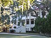 | July 24, 2003 (#03000675) | Cumberland Island 30°46′47″N81°28′07″W / 30.77979°N 81.46854°W | ||
| 6 | High Point-Half Moon Bluff Historic District | December 22, 1978 (#78000265) | NE of St. Marys on Cumberland Island 30°55′14″N81°25′56″W / 30.920556°N 81.432222°W | St. Marys | ||
| 7 | Kingsland Commercial Historic District |  | March 17, 1994 (#94000186) | Area surrounding S. Lee St. (US 17), between King and William Sts. 30°47′58″N81°41′25″W / 30.7995°N 81.69014°W | Kingsland | |
| 8 | Little Cumberland Island Lighthouse | 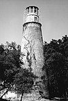 | August 28, 1989 (#89001407) | N end of Little Cumberland Island 30°58′34″N81°24′47″W / 30.97621°N 81.41310°W | St. Marys | |
| 9 | Main Road |  | February 13, 1984 (#84000941) | Cumberland Island 30°49′45″N81°27′26″W / 30.829167°N 81.457222°W | St. Marys | |
| 10 | John Houstoun McIntosh Sugarhouse |  | April 2, 1992 (#92000167) | Ga. Spur 40, 6 mi. N of St. Marys, access is from Charlie Smith Hwy. (at 30°47′35″N81°34′38″W / 30.79310°N 81.57712°W ) 30°47′36″N81°34′43″W / 30.79328°N 81.57870°W | St. Marys | |
| 11 | Orange Hall | 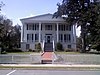 | May 7, 1973 (#73000613) | 311 Osborne St. 30°43′28″N81°32′53″W / 30.72431°N 81.54811°W | St. Marys | |
| 12 | Plum Orchard Historic District | 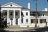 | November 23, 1984 (#84000258) | Address Restricted (on Cumberland Island) | St. Marys | |
| 13 | Rayfield Archeological District | February 13, 1984 (#84000924) | Address Restricted | St. Marys | On Cumberland Island | |
| 14 | St. Marys Historic District | 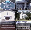 | May 13, 1976 (#76000609) | Roughly bounded by Waterfront Rd., Norris, Alexander, and Oak Grove Cemetery 30°43′24″N81°32′53″W / 30.72323°N 81.54792°W | St. Marys | |
| 15 | Stafford Plantation |  | November 23, 1984 (#84000265) | Address Restricted (on Cumberland Island) | St. Marys | The only surviving antebellum-era structures are "the chimneys," slave cabin ruins. |
| 16 | Table Point Archeological District | November 23, 1984 (#84000260) | Address Restricted | St. Marys | On Cumberland Island [5] | |
| 17 | Woodbine Historic District | 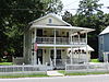 | May 12, 1999 (#99000553) | Jct. of Bedell Ave. (US 17) and 3rd and 4th Sts. and the central business district 30°58′04″N81°43′27″W / 30.967778°N 81.724167°W | Woodbine |

This is a list of the buildings, sites, districts, and objects listed on the National Register of Historic Places in the Republic of Palau. There are currently six listed sites located in only four of the sixteen states of Palau.
This National Park Service list is complete through NPS recent listings posted March 4, 2022.
List of Registered Historic Places in Marlborough, Massachusetts
This National Park Service list is complete through NPS recent listings posted March 4, 2022.

This is a list of the National Register of Historic Places listings in Washington County, Virginia.

This is a list of the National Register of Historic Places listings in Montgomery County, Virginia.

This is a list of the National Register of Historic Places listings in Sussex County, Virginia.
This is a list of properties and districts in DeKalb County, Georgia that are listed on the National Register of Historic Places (NRHP).

This is a list of properties and districts in Walton County, Georgia that are listed on the National Register of Historic Places (NRHP).
This is a list of properties and districts in Muscogee County, Georgia that are listed on the National Register of Historic Places (NRHP).
This is a list of properties and districts in Clarke County, Georgia that are listed on the National Register of Historic Places (NRHP).
This is a list of properties and districts in Gwinnett County, Georgia that are listed on the National Register of Historic Places (NRHP).

This is a list of properties and districts in Hall County, Georgia that are listed on the National Register of Historic Places (NRHP).
This is a list of properties and districts in Richmond County, Georgia that are listed on the National Register of Historic Places (NRHP).
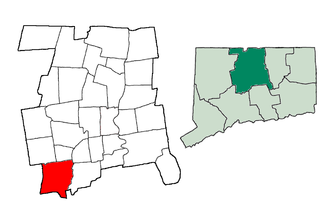
This is a list of the National Register of Historic Places listings in Southington, Connecticut.
This is a list of properties and districts in Coweta County, Georgia that are listed on the National Register of Historic Places (NRHP).
This is a list of the National Register of Historic Places listings in Zion National Park.
This is a list of the National Register of Historic Places listings in Cuyahoga Valley National Park.
This is a list of the National Register of Historic Places listings in Wind Cave National Park.
This is a list of properties and districts in Douglas County, Georgia that are listed on the National Register of Historic Places (NRHP).
Weston, Massachusetts has 15 locations listed on the National Register of Historic Places.
This National Park Service list is complete through NPS recent listings posted March 4, 2022.

Barnstable, Massachusetts, has more than 75 entries on the National Register of Historic Places. For listings elsewhere in Barnstable County, see National Register of Historic Places listings in Barnstable County, Massachusetts.
| Wikimedia Commons has media related to National Register of Historic Places in Camden County, Georgia . |
| Topics | |
|---|---|
| Lists by state |
|
| Lists by insular areas | |
| Lists by associated state | |
| Other areas | |
| Related | |
