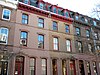
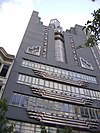
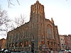
[2] Name on the Register Image Date listed [3] Location Neighborhood [4] Description 1 1616 Walnut Street Building 1616 Walnut Street Building October 17, 1983 (# 83004247 1616 Walnut Street 39°56′59″N 75°10′07″W / 39.9497°N 75.1685°W / 39.9497; -75.1685 (1616 Walnut Street Building ) Rittenhouse Square East 2 1900 Rittenhouse Square Apartments 1900 Rittenhouse Square Apartments July 26, 1982 (# 82003805 1900 South Rittenhouse Square 39°56′55″N 75°10′22″W / 39.9486°N 75.1728°W / 39.9486; -75.1728 (1900 Rittenhouse Square Apartments ) Rittenhouse Square East 3 Academy of Music Academy of Music October 15, 1966 (# 66000674 Broad and Locust Streets 39°56′53″N 75°09′54″W / 39.9481°N 75.165°W / 39.9481; -75.165 (Academy of Music ) Rittenhouse Square East Napoleon LeBrun , architect 4 Adelphi School Adelphi School September 18, 1978 (# 78002441 1223–1225 Spring Street 39°57′23″N 75°09′36″W / 39.9564°N 75.16°W / 39.9564; -75.16 (Adelphi School ) Chinatown 5 Amalgamated Center Amalgamated Center December 30, 2008 (# 08001269 2101–2143 South Street 39°56′43″N 75°10′38″W / 39.9453°N 75.1772°W / 39.9453; -75.1772 (Amalgamated Center ) Rittenhouse Square West 6 American Baptist Publication Society American Baptist Publication Society June 27, 1980 (# 80003607 1420–1422 Chestnut Street 39°57′03″N 75°09′55″W / 39.9508°N 75.1653°W / 39.9508; -75.1653 (American Baptist Publication Society ) Rittenhouse Square East Frank Miles Day , architect (1896–97). 7 American Philosophical Society Hall American Philosophical Society Hall October 15, 1966 (# 66000675 104 South 5th Street in Independence Square 39°56′56″N 75°08′59″W / 39.9489°N 75.1497°W / 39.9489; -75.1497 (American Philosophical Society Hall ) Independence Mall 8 Arch Street Meetinghouse Arch Street Meetinghouse May 27, 1971 (# 71000716 302–338 Arch Street 39°57′07″N 75°08′50″W / 39.9519°N 75.1472°W / 39.9519; -75.1472 (Arch Street Meetinghouse ) Independence Mall Designated a National Historic Landmark June 23, 2011 9 Arch Street Opera House Arch Street Opera House June 13, 1978 (# 78002442 1003–1005 Arch Street 39°57′13″N 75°09′25″W / 39.9536°N 75.1569°W / 39.9536; -75.1569 (Arch Street Opera House ) Chinatown Edwin Forrest Durang , architect 10 Arch Street Presbyterian Church Arch Street Presbyterian Church May 27, 1971 (# 71000717 1726–1732 Arch Street 39°57′16″N 75°10′11″W / 39.9544°N 75.1697°W / 39.9544; -75.1697 (Arch Street Presbyterian Church ) Logan Square Stephen Decatur Button, architect 11 Athenaeum of Philadelphia Athenaeum of Philadelphia February 1, 1972 (# 72001144 219 South 6th Street 39°56′48″N 75°09′06″W / 39.9467°N 75.1517°W / 39.9467; -75.1517 (Athenaeum of Philadelphia ) Society Hill John Notman , architect 12 Oliver H. Bair Funeral Home Oliver H. Bair Funeral Home November 14, 1982 (# 82001542 1818–1820 Chestnut Street 39°57′06″N 75°10′16″W / 39.9517°N 75.1711°W / 39.9517; -75.1711 (Oliver H. Bair Funeral Home ) Rittenhouse Square East 13 Belgravia Hotel Belgravia Hotel November 14, 1982 (# 82001543 1811 Chestnut Street 39°57′07″N 75°10′15″W / 39.9519°N 75.1708°W / 39.9519; -75.1708 (Belgravia Hotel ) Rittenhouse Square East Samuel Webber, architect 14 Bell Telephone Company Building Bell Telephone Company Building August 7, 2000 (# 00000849 1827–1835 Arch Street 39°57′20″N 75°10′15″W / 39.9556°N 75.1708°W / 39.9556; -75.1708 (Bell Telephone Company Building ) Logan Square 15 John C. Bell House John C. Bell House April 13, 1982 (# 82003807 229 South 22nd Street 39°57′00″N 75°10′39″W / 39.95°N 75.1775°W / 39.95; -75.1775 (John C. Bell House ) Rittenhouse Square West Horace Trumbauer , architect 16 Bellevue Stratford Hotel Bellevue Stratford Hotel March 24, 1977 (# 77001182 200 South Broad Street 39°56′57″N 75°09′54″W / 39.9492°N 75.165°W / 39.9492; -75.165 (Bellevue Stratford Hotel ) Rittenhouse Square East G. W. & W. D. Hewitt , architects (1902–04). 17 Benjamin Franklin Hotel Benjamin Franklin Hotel April 2, 1982 (# 82003808 822–840 Chestnut Street 39°56′58″N 75°09′19″W / 39.9494°N 75.1553°W / 39.9494; -75.1553 (Benjamin Franklin Hotel ) Market East Horace Trumbauer , architect (1925). 18 Bishop Mackay-Smith House Bishop Mackay-Smith House January 25, 1980 (# 80003608 251 South 22nd Street 39°56′57″N 75°10′40″W / 39.9492°N 75.1778°W / 39.9492; -75.1778 (Bishop Mackay-Smith House ) Rittenhouse Square West Theophilus P. Chandler Jr. , architect (1903–04). 19 Board of Education Building Board of Education Building August 25, 1983 (# 83002266 21st Street and Benjamin Franklin Parkway 39°57′32″N 75°10′28″W / 39.9589°N 75.1744°W / 39.9589; -75.1744 (Board of Education Building ) Logan Square Irwin Thornton Catharine, architect (1930). 20 Boekel Building Boekel Building February 20, 2003 (# 03000078 505–515 Vine Street 39°57′23″N 75°08′54″W / 39.9564°N 75.1483°W / 39.9564; -75.1483 (Boekel Building ) Old City 21 Broad Street Historic District Broad Street Historic District April 6, 1984 (# 84003529 Roughly bounded by Juniper, Cherry, 15th, and Pine Sts. 39°57′03″N 75°09′51″W / 39.9508°N 75.1642°W / 39.9508; -75.1642 (Broad Street Historic District ) Market East 22 Carpenters' Hall Carpenters' Hall April 15, 1970 (# 70000552 310 Chestnut Street 39°56′53″N 75°08′50″W / 39.9481°N 75.1472°W / 39.9481; -75.1472 (Carpenters' Hall ) Independence Mall 23 Cathedral of Saints Peter and Paul Cathedral of Saints Peter and Paul June 24, 1971 (# 71000720 18th Street and Benjamin Franklin Parkway 39°57′26″N 75°10′07″W / 39.9572°N 75.1686°W / 39.9572; -75.1686 (Cathedral of Saints Peter and Paul ) Logan Square Napoleon LeBrun , architect 24 Center City West Commercial Historic District Center City West Commercial Historic District January 7, 1988 (# 87002203 Roughly bounded by Chestnut, 15th, Walnut, Sansom, and 21st Streets; also roughly bounded by the Center City West Historic District, S. 15th, Locust St., and S. Sydenham St. 39°56′45″N 75°10′20″W / 39.9458°N 75.1722°W / 39.9458; -75.1722 (Center City West Commercial Historic District ) Rittenhouse Square East 25 Chateau Crillon Apartment House Chateau Crillon Apartment House April 25, 1978 (# 78002443 222 South 19th Street 39°56′57″N 75°10′24″W / 39.9492°N 75.1733°W / 39.9492; -75.1733 (Chateau Crillon Apartment House ) Rittenhouse Square East Horace Trumbauer , architect (1928). 26 Christ Church Christ Church April 15, 1970 (# 70000553 22–26 North 2nd Street 39°57′03″N 75°08′37″W / 39.9508°N 75.1436°W / 39.9508; -75.1436 (Christ Church ) Old City 27 Christ Church Burial Ground Christ Church Burial Ground June 24, 1971 (# 71000062 5th and Arch Streets 39°57′07″N 75°08′53″W / 39.9519°N 75.1481°W / 39.9519; -75.1481 (Christ Church Burial Ground ) Independence Mall 28 Church of the Holy Trinity Church of the Holy Trinity February 6, 1973 (# 73001660 19th and Walnut Streets, facing Rittenhouse Square 39°57′01″N 75°10′23″W / 39.9503°N 75.1731°W / 39.9503; -75.1731 (Church of the Holy Trinity ) Rittenhouse Square East John Notman , architect 29 Clinton Street Historic District Clinton Street Historic District April 26, 1972 (# 72001148 Bounded by 9th, 11th, Pine, and Cypress Streets 39°56′42″N 75°09′31″W / 39.945°N 75.1586°W / 39.945; -75.1586 (Clinton Street Historic District ) Washington Square West 30 College of Physicians of Philadelphia College of Physicians of Philadelphia October 6, 2008 (# 08001088 19 South 22nd Street 39°57′12″N 75°10′36″W / 39.9533°N 75.1767°W / 39.9533; -75.1767 (College of Physicians of Philadelphia ) Rittenhouse Square West Cope & Stewardson , architects 31 Edward Drinker Cope House Edward Drinker Cope House May 15, 1975 (# 75001660 2102 Pine Street 39°56′49″N 75°10′36″W / 39.9469°N 75.1767°W / 39.9469; -75.1767 (Edward Drinker Cope House ) Rittenhouse Square West Frank Furness , architect 32 Drake Hotel Drake Hotel September 18, 1978 (# 78002446 1512–1514 Spruce Street 39°56′49″N 75°10′03″W / 39.9469°N 75.1675°W / 39.9469; -75.1675 (Drake Hotel ) Rittenhouse Square East Murphy, Quigley & Co., architects 33 Drexel and Company Building Drexel and Company Building February 8, 1980 (# 80003610 135–143 South 15th Street 39°56′56″N 75°09′56″W / 39.9489°N 75.1656°W / 39.9489; -75.1656 (Drexel and Company Building ) Rittenhouse Square East Horace Trumbauer , architect 34 Drinker's Court Drinker's Court May 27, 1971 (# 71000723 236–238 Delancey Street 39°56′36″N 75°08′49″W / 39.9433°N 75.1469°W / 39.9433; -75.1469 (Drinker's Court ) Society Hill 35 Thomas Durham School Thomas Durham School November 18, 1988 (# 88002265 1600 Lombard Street 39°56′42″N 75°10′08″W / 39.945°N 75.1689°W / 39.945; -75.1689 (Thomas Durham School ) Rittenhouse Square East 36 East Center City Commercial Historic District East Center City Commercial Historic District July 5, 1984 (# 84003531 Roughly bounded by 6th, Juniper, Market and Locust Streets 39°57′05″N 75°09′33″W / 39.9514°N 75.1592°W / 39.9514; -75.1592 (East Center City Commercial Historic District ) Market East Boundary changes approved May 24, 2018 . 37 Elfreth's Alley Historic District Elfreth's Alley Historic District October 15, 1966 (# 66000681 Between 2nd and Front Streets 39°57′10″N 75°08′33″W / 39.9528°N 75.1425°W / 39.9528; -75.1425 (Elfreth's Alley Historic District ) Old City 38 Equitable Trust Building Equitable Trust Building July 3, 1986 (# 86001405 1405 Locust Street 39°56′54″N 75°09′54″W / 39.9483°N 75.165°W / 39.9483; -75.165 (Equitable Trust Building ) Rittenhouse Square East 39 Estey Hall Estey Hall October 28, 1983 (# 83004244 1701 Walnut Street 39°57′00″N 75°10′09″W / 39.95°N 75.1692°W / 39.95; -75.1692 (Estey Hall ) Rittenhouse Square East Baker & Dallet, architects 40 Wilson Eyre House Wilson Eyre House April 13, 1977 (# 77001183 1003 Spruce Street 39°56′47″N 75°09′29″W / 39.9463°N 75.1581°W / 39.9463; -75.1581 (Wilson Eyre House ) Washington Square West Wilson Eyre , architect 41 Fidelity–Philadelphia Trust Company Building Fidelity–Philadelphia Trust Company Building November 27, 1978 (# 78002447 123–151 South Broad Street 39°56′59″N 75°09′49″W / 39.9497°N 75.1636°W / 39.9497; -75.1636 (Fidelity–Philadelphia Trust Company Building ) Market East Zantzinger & Borie , architects 42 First Bank of the United States First Bank of the United States May 4, 1987 (# 87001292 116 South 3rd Street 39°56′53″N 75°08′47″W / 39.9481°N 75.1464°W / 39.9481; -75.1464 (First Bank of the United States ) Independence Mall 43 First Troop Philadelphia City Cavalry Armory First Troop Philadelphia City Cavalry Armory July 24, 2017 (# 90000420 22 S. 23rd St. 39°57′12″N 75°10′43″W / 39.953263°N 75.178518°W / 39.953263; -75.178518 (First Troop Philadelphia City Cavalry Armory ) Rittenhouse Square West 44 First Unitarian Church First Unitarian Church May 27, 1971 (# 71000724 2121 Chestnut Street 39°57′09″N 75°10′35″W / 39.9525°N 75.1764°W / 39.9525; -75.1764 (First Unitarian Church ) Rittenhouse Square West Frank Furness , architect (1883–86). 45 Franklin Institute Franklin Institute August 1, 1979 (# 79002319 15 South 7th Street 39°57′01″N 75°09′07″W / 39.9503°N 75.1519°W / 39.9503; -75.1519 (Franklin Institute ) Independence Mall John Haviland , architect. Now the Atwater Kent Museum . 46 Franklin Institute Science Museum Franklin Institute Science Museum January 3, 1985 (# 85000039 20th St. and the Benjamin Franklin Parkway 39°57′29″N 75°10′23″W / 39.958°N 75.173°W / 39.958; -75.173 (Franklin Institute Science Museum ) Logan Square John T. Windrim , architect (1929–31). 47 Franklin Square Franklin Square September 14, 1981 (# 81000556 Race and 6th Streets 39°57′20″N 75°09′03″W / 39.9556°N 75.1508°W / 39.9556; -75.1508 (Franklin Square ) Chinatown 48 Free Quaker Meetinghouse Free Quaker Meetinghouse September 22, 1971 (# 71000063 Southwestern corner of 5th and Arch Streets 39°57′09″N 75°08′55″W / 39.9525°N 75.1486°W / 39.9525; -75.1486 (Free Quaker Meetinghouse ) Independence Mall 49 Henry George Birthplace Henry George Birthplace April 1, 1983 (# 83002268 413 South 10th Street 39°56′39″N 75°09′30″W / 39.9442°N 75.1582°W / 39.9442; -75.1582 (Henry George Birthplace ) Washington Square West 50 Girard Group Girard Group May 6, 1983 (# 83002269 Delaware Avenue and Arch Street 39°57′05″N 75°08′22″W / 39.9514°N 75.1394°W / 39.9514; -75.1394 (Girard Group ) Penn's Landing 51 Globe Ticket Company Building Globe Ticket Company Building November 1, 1984 (# 84000268 112 North 12th Street 39°57′11″N 75°09′28″W / 39.9531°N 75.1578°W / 39.9531; -75.1578 (Globe Ticket Company Building ) Chinatown Destroyed to build the Pennsylvania Convention Center 52 Harris Building Harris Building August 31, 2001 (# 01000928 2121–2141 Market Street 39°57′15″N 75°10′34″W / 39.9542°N 75.1761°W / 39.9542; -75.1761 (Harris Building ) Logan Square 53 Head House Square Head House Square June 19, 1972 (# 72001158 Both sides of the 400 block of South 2nd Street 39°56′34″N 75°08′43″W / 39.9428°N 75.1453°W / 39.9428; -75.1453 (Head House Square ) Society Hill 54 Heywood Chair Factory Heywood Chair Factory August 23, 1984 (# 84003541 1010–1014 Race Street 39°57′19″N 75°09′23″W / 39.9553°N 75.1564°W / 39.9553; -75.1564 (Heywood Chair Factory ) Chinatown Willis G. Hale , architect (1892). 55 Hill-Physick House Hill-Physick House May 27, 1971 (# 71000726 321 South 4th Street 39°56′39″N 75°08′54″W / 39.9443°N 75.1483°W / 39.9443; -75.1483 (Hill-Physick House ) Society Hill 56 Hockley Row Hockley Row April 21, 1983 (# 83002272 237–241 South 21st Street, 2049 Locust Street 39°56′59″N 75°10′35″W / 39.9497°N 75.1764°W / 39.9497; -75.1764 (Hockley Row ) Rittenhouse Square West Frank Furness , architect (1875). 57 A.J. Holman and Company A.J. Holman and Company May 17, 1984 (# 84003544 1222–1226 Arch Street 39°57′14″N 75°09′38″W / 39.9539°N 75.1606°W / 39.9539; -75.1606 (A.J. Holman and Company ) Chinatown 58 Houses at 2000–2018 Delancey Street Houses at 2000–2018 Delancey Street April 22, 1982 (# 82003809 2000–2018 Delancey Street 39°56′51″N 75°10′33″W / 39.9475°N 75.1758°W / 39.9475; -75.1758 (Houses at 2000–2018 Delancey Street ) Rittenhouse Square West 59 Independence National Historical Park Independence National Historical Park October 15, 1966 (# 66000683 Bounded by Walnut, 6th, Chestnut, and 2nd Streets 39°56′52″N 75°08′53″W / 39.9478°N 75.1481°W / 39.9478; -75.1481 (Independence National Historical Park ) Independence Mall 60 Insurance Company of North America Building Insurance Company of North America Building June 2, 1978 (# 78002449 1600 Arch Street 39°57′16″N 75°10′02″W / 39.9544°N 75.1672°W / 39.9544; -75.1672 (Insurance Company of North America Building ) Logan Square 61 Horace Jayne House Horace Jayne House July 22, 1982 (# 82003810 320 South 19th Street 39°56′50″N 75°10′23″W / 39.9472°N 75.1731°W / 39.9472; -75.1731 (Horace Jayne House ) Rittenhouse Square East Frank Furness , architect (1895) 62 Juvenile and Domestic Branches of the Municipal Court Juvenile and Domestic Branches of the Municipal Court March 31, 2014 (# 14000097 1801 Vine St. 39°57′34″N 75°10′10″W / 39.959384°N 75.169478°W / 39.959384; -75.169478 (Juvenile and Domestic Branches of the Municipal Court ) Logan Square 63 Thaddeus Kosciuszko National Memorial Thaddeus Kosciuszko National Memorial December 18, 1970 (# 70000068 301 Pine Street 39°56′36″N 75°08′51″W / 39.9433°N 75.1475°W / 39.9433; -75.1475 (Thaddeus Kosciuszko National Memorial ) Society Hill 64 Land Title Building Land Title Building December 15, 1978 (# 78002450 1400 Chestnut Street 39°57′01″N 75°09′52″W / 39.9503°N 75.1644°W / 39.9503; -75.1644 (Land Title Building ) Market East Daniel Burnham (1897–1898), Horace Trumbauer (1902), architects. 65 Larkin-Belber Building Larkin-Belber Building February 27, 2003 (# 03000077 2200–2218 Arch Street 39°57′21″N 75°10′36″W / 39.9557°N 75.1767°W / 39.9557; -75.1767 (Larkin-Belber Building ) Logan Square 66 Dr. Joseph Leidy House Dr. Joseph Leidy House December 4, 1980 (# 80003613 1319 Locust Street 39°56′52″N 75°09′50″W / 39.9478°N 75.1639°W / 39.9478; -75.1639 (Dr. Joseph Leidy House ) Washington Square West Wilson Eyre , architect 67 J. Peter Lesley House J. Peter Lesley House October 12, 1994 (# 94001646 1008 Clinton Street 39°56′43″N 75°09′31″W / 39.9453°N 75.1586°W / 39.9453; -75.1586 (J. Peter Lesley House ) Washington Square West 68 Lits Department Store Lits Department Store May 15, 1979 (# 79002322 Market Street between 7th and 8th Streets 39°57′05″N 75°09′10″W / 39.9514°N 75.1528°W / 39.9514; -75.1528 (Lits Department Store ) Independence Mall 69 Logan Square Logan Square September 14, 1981 (# 81000555 18th and Race Streets 39°57′28″N 75°10′15″W / 39.9578°N 75.1708°W / 39.9578; -75.1708 (Logan Square ) Logan Square Eyre & McIlvaine , architects. Alexander Stirling Calder , sculptor 70 Mask and Wig Club of the University of Pennsylvania Mask and Wig Club of the University of Pennsylvania November 20, 1979 (# 79002323 310 South Quince Street 39°56′46″N 75°09′37″W / 39.946°N 75.1604°W / 39.946; -75.1604 (Mask and Wig Club of the University of Pennsylvania ) Washington Square West Wilson Eyre , architect 71 Masonic Temple Masonic Temple May 27, 1971 (# 71000727 1 North Broad Street 39°57′13″N 75°09′46″W / 39.9536°N 75.1628°W / 39.9536; -75.1628 (Masonic Temple ) Market East James H. Windrim , architect (1868–73). 72 Francis McIlvain House Francis McIlvain House November 20, 1979 (# 79002324 1924 Arch Street 39°57′19″N 75°10′20″W / 39.9553°N 75.1722°W / 39.9553; -75.1722 (Francis McIlvain House ) Logan Square 73 Merchants' Exchange Building Merchants' Exchange Building August 7, 2001 (# 01001047 143 South 3rd Street 39°56′50″N 75°08′46″W / 39.9472°N 75.1461°W / 39.9472; -75.1461 (Merchants' Exchange Building ) Independence Mall William Strickland , architect 74 Mikveh Israel Cemetery Mikveh Israel Cemetery June 24, 1971 (# 71000061 Northwestern corner of Spruce and Darien Streets 39°56′46″N 75°09′21″W / 39.9461°N 75.1557°W / 39.9461; -75.1557 (Mikveh Israel Cemetery ) Washington Square West 75 Clarence B. Moore House Clarence B. Moore House May 8, 1973 (# 73001664 1321 Locust Street 39°56′54″N 75°09′53″W / 39.9482°N 75.1646°W / 39.9482; -75.1646 (Clarence B. Moore House ) Rittenhouse Square East Wilson Eyre , architect 76 Mother Bethel A.M.E. Church Mother Bethel A.M.E. Church March 16, 1972 (# 72001166 419 South 6th Street 39°56′35″N 75°09′09″W / 39.9431°N 75.1525°W / 39.9431; -75.1525 (Mother Bethel A.M.E. Church ) Society Hill 77 Musical Fund Hall Musical Fund Hall March 11, 1971 (# 71000730 808 Locust Street 39°56′49″N 75°09′18″W / 39.9469°N 75.155°W / 39.9469; -75.155 (Musical Fund Hall ) Washington Square West William Strickland , architect of alterations into concert hall. 78 Neill-Mauran House Neill-Mauran House June 30, 1980 (# 80003614 315–317 South 22nd Street 39°56′53″N 75°10′40″W / 39.9481°N 75.1778°W / 39.9481; -75.1778 (Neill-Mauran House ) Rittenhouse Square West Wilson Eyre , architect 79 New Century Guild New Century Guild November 4, 1993 (# 93001611 1307 Locust Street 39°56′49″N 75°09′46″W / 39.9469°N 75.1628°W / 39.9469; -75.1628 (New Century Guild ) Washington Square West 80 New Market New Market November 13, 1966 (# 66000686 South 2nd Street, between Pine and Lombard Streets 39°56′35″N 75°08′43″W / 39.9431°N 75.1453°W / 39.9431; -75.1453 (New Market ) Society Hill Includes oldest firehouse in US (1804) 81 New York Mutual Life Insurance Company Building New York Mutual Life Insurance Company Building June 6, 1980 (# 80003615 1001–1005 Chestnut Street 39°57′01″N 75°09′26″W / 39.9503°N 75.1572°W / 39.9503; -75.1572 (New York Mutual Life Insurance Company Building ) Market East Henry Fernbach , architect (1873–75). 82 Old City Historic District Old City Historic District May 5, 1972 (# 72000093 Old city area including parts of Washington Square East Development Area and Franklin Square East Development Area 39°56′58″N 75°08′44″W / 39.9494°N 75.1456°W / 39.9494; -75.1456 (Old City Historic District ) Old City 83 Old Federal Reserve Bank Old Federal Reserve Bank June 28, 1979 (# 79002325 925 Chestnut Street 39°57′01″N 75°09′24″W / 39.9503°N 75.1567°W / 39.9503; -75.1567 (Old Federal Reserve Bank ) Market East Paul Cret , architect 84 Packard Motor Corporation Building Packard Motor Corporation Building February 8, 1980 (# 80003616 317–321 North Broad Street 39°57′31″N 75°09′41″W / 39.9586°N 75.1614°W / 39.9586; -75.1614 (Packard Motor Corporation Building ) Callowhill Albert Kahn, architect (1910). 85 Park Towne Place Park Towne Place December 15, 2011 (# 11000926 2200 Park Towne Place 39°57′40″N 75°10′39″W / 39.961062°N 75.177524°W / 39.961062; -75.177524 (Park Towne Place ) Logan Square Louis I. Kahn , architect 86 Penn Towers Penn Towers December 12, 2012 (# 12001045 1815 John F. Kennedy Boulevard 39°57′16″N 75°10′14″W / 39.954444°N 75.170556°W / 39.954444; -75.170556 (Penn Towers ) Logan Square 87 Pennsylvania Academy of the Fine Arts Pennsylvania Academy of the Fine Arts May 27, 1971 (# 71000731 Southwestern corner of Broad and Cherry Streets 39°57′19″N 75°09′48″W / 39.9553°N 75.1633°W / 39.9553; -75.1633 (Pennsylvania Academy of the Fine Arts ) Hahnemann Furness & Hewitt , architects (1871–76). 88 Pennsylvania Hospital Pennsylvania Hospital October 15, 1966 (# 66000688 8th and Spruce Streets 39°56′41″N 75°09′21″W / 39.9447°N 75.1558°W / 39.9447; -75.1558 (Pennsylvania Hospital ) Washington Square West 89 Philadelphia City Hall Philadelphia City Hall December 8, 1976 (# 76001666 Penn Square, Broad and Market Streets 39°57′08″N 75°09′49″W / 39.9522°N 75.1636°W / 39.9522; -75.1636 (Philadelphia City Hall ) Market East John McArthur Jr. (1874–1901), architect 90 Philadelphia College of Art Philadelphia College of Art May 27, 1971 (# 71000733 Northwestern corner of Broad and Pine Streets 39°56′46″N 75°09′56″W / 39.946°N 75.1656°W / 39.946; -75.1656 (Philadelphia College of Art ) Rittenhouse Square East John Haviland , architect (1824–26). Frank Furness , architect of addition (1874–75). 91 Philadelphia Contributionship Philadelphia Contributionship May 27, 1971 (# 71000732 212 South 4th Street 39°56′48″N 75°08′54″W / 39.9468°N 75.1482°W / 39.9468; -75.1482 (Philadelphia Contributionship ) Society Hill 92 Philadelphia Racquet Club Philadelphia Racquet Club August 1, 1979 (# 79002326 213–225 South 16th Street 39°56′56″N 75°10′05″W / 39.9489°N 75.1681°W / 39.9489; -75.1681 (Philadelphia Racquet Club ) Rittenhouse Square East Horace Trumbauer , architect 93 Philadelphia Savings Fund Society Building Philadelphia Savings Fund Society Building December 8, 1976 (# 76001667 Southwestern corner of Market and 12th Streets 39°57′06″N 75°09′38″W / 39.9517°N 75.1606°W / 39.9517; -75.1606 (Philadelphia Savings Fund Society Building ) Market East George Howe and William Lescaze , architects 94 Philadelphia School of Occupational Therapy Philadelphia School of Occupational Therapy June 13, 2003 (# 03000528 419 South 19th Street 39°56′45″N 75°10′23″W / 39.9458°N 75.1731°W / 39.9458; -75.1731 (Philadelphia School of Occupational Therapy ) Rittenhouse Square East 95 Philadelphia Stock Exchange Philadelphia Stock Exchange August 31, 1982 (# 82003812 1409–1411 Walnut Street 39°56′59″N 75°09′54″W / 39.949662°N 75.164899°W / 39.949662; -75.164899 (Philadelphia Stock Exchange ) Rittenhouse Square East Horace Trumbauer , architects 96 Physicians and Dentists Building Physicians and Dentists Building November 5, 1987 (# 87001968 1831–1833 Chestnut Street 39°57′07″N 75°10′17″W / 39.9519°N 75.1715°W / 39.9519; -75.1715 (Physicians and Dentists Building ) Rittenhouse Square West Wilson Brothers & Company , architects 97 Pitcairn Building Pitcairn Building January 7, 1988 (# 87002209 1027 Arch Street 39°57′14″N 75°09′27″W / 39.9539°N 75.1575°W / 39.9539; -75.1575 (Pitcairn Building ) Chinatown G. W. & W. D. Hewitt , architects 98 Plays and Players Plays and Players March 14, 1973 (# 73001665 1714 Delancey Street 39°56′49″N 75°10′14″W / 39.9469°N 75.1706°W / 39.9469; -75.1706 (Plays and Players ) Rittenhouse Square East 99 Portico Row Portico Row December 16, 1977 (# 77001189 900–930 Spruce Street 39°56′45″N 75°09′29″W / 39.9458°N 75.1581°W / 39.9458; -75.1581 (Portico Row ) Washington Square West Thomas U. Walter , architect 100 Princeton Club Princeton Club December 4, 1980 (# 80003617 1221–1223 Locust Street 39°56′53″N 75°09′41″W / 39.9481°N 75.1614°W / 39.9481; -75.1614 (Princeton Club ) Washington Square West Frank Furness , architect of 1223 Locust (1890). Lindley Johnson, architect of 1221 Locust (1891) 101 Race Street Friends Meetinghouse Race Street Friends Meetinghouse November 4, 1993 (# 93001610 1515 Cherry Street 39°57′21″N 75°09′54″W / 39.9558°N 75.1651°W / 39.9558; -75.1651 (Race Street Friends Meetinghouse ) Hahnemann 102 Rafsnyder-Welsh House Rafsnyder-Welsh House February 14, 1980 (# 80003618 1923 Spruce Street 39°56′53″N 75°10′27″W / 39.9481°N 75.1742°W / 39.9481; -75.1742 (Rafsnyder-Welsh House ) Rittenhouse Square East 103 Ramcat Historic District Ramcat Historic District January 8, 1986 (# 86000055 Roughly bounded by Market, 23rd, and Bainbridge Streets, and railroad yards 39°56′55″N 75°10′54″W / 39.9486°N 75.1817°W / 39.9486; -75.1817 (Ramcat Historic District ) Rittenhouse Square West 104 J. Sylvester Ramsey School J. Sylvester Ramsey School December 1, 1986 (# 86003322 Pine and Quince Streets 39°56′42″N 75°09′37″W / 39.9451°N 75.1604°W / 39.9451; -75.1604 (J. Sylvester Ramsey School ) Washington Square West Destroyed see old photo at 105 Reading Terminal and Trainshed Reading Terminal and Trainshed June 30, 1972 (# 72001170 1115–1141 Market Street 39°57′08″N 75°09′33″W / 39.9522°N 75.1592°W / 39.9522; -75.1592 (Reading Terminal and Trainshed ) Market East Francis H. Kimball and Wilson Brothers & Company , architects 106 Reynolds-Morris House Reynolds-Morris House December 24, 1967 (# 67000020 225 South 8th Street 39°56′51″N 75°09′15″W / 39.9474°N 75.1543°W / 39.9474; -75.1543 (Reynolds-Morris House ) Washington Square West 107 Ringgold Place Ringgold Place August 29, 1978 (# 78002453 1900 block of Waverly Street 39°56′46″N 75°10′28″W / 39.9461°N 75.1744°W / 39.9461; -75.1744 (Ringgold Place ) Rittenhouse Square East 108 Rittenhouse Historic District Rittenhouse Historic District August 25, 1983 (# 83002277 Roughly bounded by Waverly, 15th, Sanson, Ludlow, 23rd, and 25th Streets; also roughly bounded by the Center City West Historic District, South Twenty-first Street, the original Rittenhouse Historic District, and South Seventeenth Street 39°56′54″N 75°10′15″W / 39.9483°N 75.1708°W / 39.9483; -75.1708 (Rittenhouse Historic District ) Rittenhouse Square East Second set of boundaries represents a boundary increase of December 27, 2010 109 Rittenhouse Square Rittenhouse Square September 14, 1981 (# 81000557 Rittenhouse Square and 18th Street 39°56′57″N 75°10′20″W / 39.9492°N 75.1722°W / 39.9492; -75.1722 (Rittenhouse Square ) Rittenhouse Square East 110 Roberts-Quay House Roberts-Quay House November 13, 1976 (# 76001668 1035–1037 Spruce Street 39°56′47″N 75°09′35″W / 39.9464°N 75.1597°W / 39.9464; -75.1597 (Roberts-Quay House ) Washington Square West 111 Rohm and Haas Corporate Headquarters Rohm and Haas Corporate Headquarters February 9, 2007 (# 07000031 100 Independence Mall West 39°57′01″N 75°09′05″W / 39.9503°N 75.1514°W / 39.9503; -75.1514 (Rohm and Haas Corporate Headquarters ) Independence Mall 112 St. Augustine's Catholic Church St. Augustine's Catholic Church June 15, 1976 (# 76001670 4th and New Streets 39°57′20″N 75°08′47″W / 39.9556°N 75.1464°W / 39.9556; -75.1464 (St. Augustine's Catholic Church ) Old City Napoleon LeBrun , architect 113 St. Clement's Protestant Episcopal Church St. Clement's Protestant Episcopal Church November 20, 1970 (# 70000555 Southwestern corner of 20th and Cherry Streets 39°57′23″N 75°10′23″W / 39.9564°N 75.1731°W / 39.9564; -75.1731 (St. Clement's Protestant Episcopal Church ) Logan Square John Notman , architect 114 St. George's Methodist Church St. George's Methodist Church May 27, 1971 (# 71000064 324 New Street 39°57′19″N 75°08′46″W / 39.9553°N 75.146°W / 39.9553; -75.146 (St. George's Methodist Church ) Old City 115 St. James Hotel St. James Hotel November 13, 1976 (# 76001671 1226–1232 Walnut Street 39°56′56″N 75°09′43″W / 39.9489°N 75.1619°W / 39.9489; -75.1619 (St. James Hotel ) Washington Square West Horace Trumbauer , architect (1901) 116 St. Mark's Episcopal Church St. Mark's Episcopal Church April 19, 1982 (# 82003815 1607–1627 Locust Street 39°56′56″N 75°10′07″W / 39.9489°N 75.1686°W / 39.9489; -75.1686 (St. Mark's Episcopal Church ) Rittenhouse Square East John Notman , architect 117 St. Peter's Church St. Peter's Church June 18, 1996 (# 96000969 Junction of 3rd and Pine Streets 39°56′35″N 75°08′52″W / 39.9431°N 75.1478°W / 39.9431; -75.1478 (St. Peter's Church ) Society Hill 118 St. Stephen's Episcopal Church St. Stephen's Episcopal Church June 4, 1979 (# 79002329 19 South 10th Street 39°57′03″N 75°09′24″W / 39.9508°N 75.1567°W / 39.9508; -75.1567 (St. Stephen's Episcopal Church ) Market East William Strickland , architect 119 Second Bank of the United States Second Bank of the United States May 4, 1987 (# 87001293 420 Chestnut Street 39°56′55″N 75°08′54″W / 39.9486°N 75.1483°W / 39.9486; -75.1483 (Second Bank of the United States ) Independence Mall William Strickland , architect 120 Smyth Young Field Company Building Smyth Young Field Company Building December 24, 1992 (# 92001720 1216–1220 Arch Street 39°57′14″N 75°09′37″W / 39.9539°N 75.1603°W / 39.9539; -75.1603 (Smyth Young Field Company Building ) Chinatown 121 Social Service Building Social Service Building February 20, 2002 (# 02000063 311 South Juniper Street 39°56′46″N 75°09′49″W / 39.9461°N 75.1636°W / 39.9461; -75.1636 (Social Service Building ) Washington Square West Horace Trumbauer , architect 122 Society Hill Historic District Society Hill Historic District June 23, 1971 (# 71000065 Bounded on the north by Walnut St., on the south by Lombard St., on the east by the pier line of the Delaware River, and on the west by 8th 39°56′42″N 75°08′58″W / 39.945°N 75.1494°W / 39.945; -75.1494 (Society Hill Historic District ) Society Hill 123 Solomon House Solomon House August 24, 1978 (# 78002454 130–132 South 17th Street 39°57′02″N 75°10′09″W / 39.9506°N 75.1692°W / 39.9506; -75.1692 (Solomon House ) Rittenhouse Square East Frank Furness , architect (1887). 124 John Stewart Houses John Stewart Houses November 20, 1979 (# 79002330 1020–1028 Spruce Street 39°56′46″N 75°09′32″W / 39.9461°N 75.1588°W / 39.9461; -75.1588 (John Stewart Houses ) Washington Square West 125 William Strickland Row William Strickland Row September 14, 1977 (# 77001192 215–227 South 9th Street 39°56′51″N 75°09′21″W / 39.9474°N 75.1558°W / 39.9474; -75.1558 (William Strickland Row ) Washington Square West William Strickland , architect 126 Suburban Station Building Suburban Station Building September 5, 1985 (# 85001962 1617 John F. Kennedy Boulevard 39°57′15″N 75°10′03″W / 39.9542°N 75.1675°W / 39.9542; -75.1675 (Suburban Station Building ) Logan Square 127 Thomas Sully Residence Thomas Sully Residence October 15, 1966 (# 66000691 530 Spruce Street 39°56′42″N 75°09′05″W / 39.945°N 75.1514°W / 39.945; -75.1514 (Thomas Sully Residence ) Society Hill 128 Sun Oil Building Sun Oil Building August 25, 1983 (# 83002280 1608–1610 Walnut Street 39°56′59″N 75°10′05″W / 39.9497°N 75.1681°W / 39.9497; -75.1681 (Sun Oil Building ) Rittenhouse Square East 129 The Touraine The Touraine April 7, 1982 (# 82003816 1520 Spruce Street 39°56′50″N 75°10′03″W / 39.9472°N 75.1676°W / 39.9472; -75.1676 (The Touraine ) Rittenhouse Square East 130 Union League of Philadelphia Union League of Philadelphia June 22, 1979 (# 79002331 140 South Broad Street 39°56′57″N 75°09′52″W / 39.9492°N 75.1644°W / 39.9492; -75.1644 (Union League of Philadelphia ) Rittenhouse Square East John Fraser , architect 131 United States Custom House United States Custom House May 25, 2011 (# 11000310 200 Chestnut St. 39°56′53″N 75°08′40″W / 39.9481°N 75.1444°W / 39.9481; -75.1444 (United States Custom House ) Independence Mall 132 US Court House and Post Office Building US Court House and Post Office Building October 19, 1990 (# 90001540 900 Market St. [5] 39°57′04″N 75°09′20″W / 39.9511°N 75.1556°W / 39.9511; -75.1556 (US Court House and Post Office Building ) Market East 133 USS BECUNA (SS–319) USS BECUNA (SS–319) August 29, 1978 (# 78002458 Penn's Landing, Delaware Avenue, and Spruce Street 39°56′36″N 75°08′29″W / 39.9433°N 75.1413°W / 39.9433; -75.1413 (USS BECUNA (SS–319) ) Penn's Landing 134 U.S.S. OLYMPIA U.S.S. OLYMPIA October 15, 1966 (# 66000692 Pier 40 at foot of Chestnut Street 39°56′36″N 75°08′28″W / 39.9433°N 75.141°W / 39.9433; -75.141 (U.S.S. OLYMPIA ) Penn's Landing 135 Walnut-Chancellor Historic District Walnut-Chancellor Historic District December 1, 1980 (# 80003605 20th-21st, Walnut and Chancellor Streets 39°57′02″N 75°10′33″W / 39.9506°N 75.1758°W / 39.9506; -75.1758 (Walnut-Chancellor Historic District ) Rittenhouse Square West 136 Walnut Street Theatre Walnut Street Theatre October 15, 1966 (# 66000693 9th and Walnut Streets 39°56′54″N 75°09′20″W / 39.9483°N 75.1556°W / 39.9483; -75.1556 (Walnut Street Theatre ) Washington Square West John Haviland , architect 137 John Wanamaker Store John Wanamaker Store June 2, 1978 (# 78002459 Juniper and Market Streets 39°57′06″N 75°09′44″W / 39.9518°N 75.1621°W / 39.9518; -75.1621 (John Wanamaker Store ) Market East Daniel Burnham , architect 138 Warburton House Warburton House August 22, 2002 (# 02000890 1929 Sansom Street 39°57′05″N 75°10′24″W / 39.9514°N 75.1733°W / 39.9514; -75.1733 (Warburton House ) Rittenhouse Square East 139 The Warwick The Warwick August 10, 1978 (# 78002460 1701 Locust Street 39°56′56″N 75°10′10″W / 39.9489°N 75.1694°W / 39.9489; -75.1694 (The Warwick ) Rittenhouse Square East 140 Washington Square Washington Square September 14, 1981 (# 81000558 Locust and 6th Streets 39°56′49″N 75°09′10″W / 39.9469°N 75.1528°W / 39.9469; -75.1528 (Washington Square ) Independence Mall 141 Washington Square West Historic District Washington Square West Historic District September 20, 1984 (# 84003563 Roughly bounded by 8th, Locust, Broad, and Lombard Streets 39°56′44″N 75°09′40″W / 39.9456°N 75.1611°W / 39.9456; -75.1611 (Washington Square West Historic District ) Washington Square West 142 Waverly Garage Waverly Garage April 17, 2018 (# 100002343 414-422 S 16th St. 39°56′44″N 75°10′06″W / 39.945487°N 75.168451°W / 39.945487; -75.168451 (Waverly Garage ) Rittenhouse Square East 143 WCAU Studios WCAU Studios January 27, 1983 (# 83002281 1618–1622 Chestnut Street 39°57′04″N 75°10′05″W / 39.9511°N 75.1681°W / 39.9511; -75.1681 (WCAU Studios ) Rittenhouse Square East 144 Wesley AME Zion Church Wesley AME Zion Church December 1, 1978 (# 78002461 1500 Lombard Street 39°56′41″N 75°10′02″W / 39.9447°N 75.1672°W / 39.9447; -75.1672 (Wesley AME Zion Church ) Rittenhouse Square East 145 Wesley Building Wesley Building May 10, 1984 (# 84003581 1701–1709 Arch Street 39°57′18″N 75°10′06″W / 39.955°N 75.1682°W / 39.955; -75.1682 (Wesley Building ) Logan Square 146 Witherspoon Building Witherspoon Building September 18, 1978 (# 78002462 1319–1323 Walnut Street 39°56′58″N 75°09′48″W / 39.9494°N 75.1633°W / 39.9494; -75.1633 (Witherspoon Building ) Market East Joseph Miller Huston , architect (1895–97). 147 Young Men's Christian Association Young Men's Christian Association December 2, 1980 (# 80003624 115 North 15th Street 39°57′18″N 75°09′53″W / 39.9551°N 75.1646°W / 39.9551; -75.1646 (Young Men's Christian Association ) Hahnemann