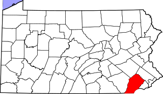
[3] Name on the Register Image Date listed [4] Location Municipality Description 1 Aaronsburg Historic District Aaronsburg Historic District September 2, 1980 (# 80003452 Pennsylvania Route 45 in Aaronsburg 40°54′02″N 77°27′10″W / 40.900556°N 77.452778°W / 40.900556; -77.452778 (Aaronsburg Historic District ) Haines Township 2 Ag Hill Complex Ag Hill Complex January 22, 1979 (# 79002191 Penn State University campus 40°47′59″N 77°51′54″W / 40.799722°N 77.865°W / 40.799722; -77.865 (Ag Hill Complex ) State College 3 William Allison House William Allison House April 18, 1977 (# 77001146 1 mile (1.6 km) west of Spring Mills on Pennsylvania Route 45 40°51′05″N 77°34′55″W / 40.851389°N 77.581944°W / 40.851389; -77.581944 (William Allison House ) Gregg Township 4 Bucher Ayres Farm Bucher Ayres Farm December 1, 1980 (# 80003453 Southwest of Pine Grove Mills on Whitehall Road, Pennsylvania Furnace 40°43′21″N 77°57′54″W / 40.7225°N 77.965°W / 40.7225; -77.965 (Bucher Ayres Farm ) Ferguson Township 5 Christian Bechdel II House Christian Bechdel II House March 1, 1982 (# 82003775 South of Blanchard on Liberty Road 41°03′31″N 77°36′16″W / 41.058611°N 77.604444°W / 41.058611; -77.604444 (Christian Bechdel II House ) Liberty Township 6 William Henry and Clara Singer Beck Farm Upload image August 31, 2017 (# 100001570 950 Snydertown Rd., southeast of Howard 40°59′13″N 77°34′39″W / 40.986944°N 77.577500°W / 40.986944; -77.577500 (William Henry and Clara Singer Beck Farm ) Walker Township 7 Bellefonte Armory Bellefonte Armory December 22, 1989 (# 89002068 East Bishop Street 40°54′55″N 77°45′25″W / 40.915278°N 77.756944°W / 40.915278; -77.756944 (Bellefonte Armory ) Bellefonte 8 Bellefonte Forge House Bellefonte Forge House August 20, 1999 (# 99001020 4098 Axemann Road 40°54′21″N 77°46′41″W / 40.905833°N 77.778056°W / 40.905833; -77.778056 (Bellefonte Forge House ) Spring Township 9 Bellefonte Historic District Bellefonte Historic District August 12, 1977 (# 77001136 Roughly bounded by Stony Batter, Ardell Alley, Thomas, Armor, Penn, Ridge and Logan Streets 40°54′48″N 77°46′43″W / 40.913333°N 77.778611°W / 40.913333; -77.778611 (Bellefonte Historic District ) Bellefonte 10 Black Moshannon State Park Day Use District Black Moshannon State Park Day Use District February 12, 1987 (# 87000101 9 miles (14 km) east of Philipsburg on Pennsylvania Route 504 40°54′57″N 78°03′46″W / 40.915833°N 78.062778°W / 40.915833; -78.062778 (Black Moshannon State Park Day Use District ) Rush Township 11 Black Moshannon State Park Family Cabin District Black Moshannon State Park Family Cabin District February 12, 1987 (# 87000102 9 miles (14 km) east of Philipsburg on Pennsylvania Route 504 40°54′48″N 78°03′45″W / 40.913333°N 78.0625°W / 40.913333; -78.0625 (Black Moshannon State Park Family Cabin District ) Rush Township 12 Black Moshannon State Park Maintenance District Black Moshannon State Park Maintenance District February 12, 1987 (# 87000097 9 miles (14 km) east of Philipsburg on Pennsylvania Route 504 40°55′15″N 78°04′24″W / 40.920833°N 78.073333°W / 40.920833; -78.073333 (Black Moshannon State Park Maintenance District ) Rush Township 13 Boal Mansion Boal Mansion December 4, 1978 (# 78002361 U.S. Route 322 and Pennsylvania Route 45 in Boalsburg 40°46′44″N 77°48′01″W / 40.778889°N 77.800278°W / 40.778889; -77.800278 (Boal Mansion ) Harris Township 14 Boalsburg Historic District Boalsburg Historic District December 12, 1977 (# 77001139 U.S. Route 322 in Boalsburg 40°46′34″N 77°47′38″W / 40.776111°N 77.793889°W / 40.776111; -77.793889 (Boalsburg Historic District ) Harris Township 15 Brockerhoff Hotel Brockerhoff Hotel April 11, 1977 (# 77001137 High and Allegheny Streets 40°54′42″N 77°46′42″W / 40.911667°N 77.778333°W / 40.911667; -77.778333 (Brockerhoff Hotel ) Bellefonte 16 Brockerhoff Mill Brockerhoff Mill May 1, 1979 (# 79002180 Southwest of Bellefonte on Pennsylvania Route 550 40°54′01″N 77°47′58″W / 40.900278°N 77.799444°W / 40.900278; -77.799444 (Brockerhoff Mill ) Benner Township 17 Camelot Camelot April 26, 1979 (# 79002192 520 South Fraser Street 40°47′20″N 77°51′29″W / 40.788889°N 77.858056°W / 40.788889; -77.858056 (Camelot ) State College 18 Centre County Courthouse Centre County Courthouse November 7, 1976 (# 76001618 High Street 40°54′43″N 77°46′40″W / 40.912083°N 77.777778°W / 40.912083; -77.777778 (Centre County Courthouse ) Bellefonte 19 Centre Furnace Mansion House Centre Furnace Mansion House December 27, 1979 (# 79002193 1001 East College Avenue 40°48′23″N 77°50′33″W / 40.806389°N 77.8425°W / 40.806389; -77.8425 (Centre Furnace Mansion House ) State College 20 Centre Mills Centre Mills December 12, 1976 (# 76001621 Southwest of Rebersburg off Pennsylvania Route 445 40°55′32″N 77°28′21″W / 40.925556°N 77.4725°W / 40.925556; -77.4725 (Centre Mills ) Miles Township 21 College Heights Historic District College Heights Historic District April 27, 1995 (# 95000514 Roughly bounded by Holmes Street, Park Avenue, Ridge Avenuie, Sunset Road, Hillcrest Avenue, Woodland Drive and Mitchell Avenue 40°47′57″N 77°52′28″W / 40.799167°N 77.874444°W / 40.799167; -77.874444 (College Heights Historic District ) State College 22 Curtin Village Curtin Village March 11, 1971 (# 71000687 Off U.S. Route 220 40°58′26″N 77°44′33″W / 40.973889°N 77.7425°W / 40.973889; -77.7425 (Curtin Village ) Boggs Township 23 Felix Dale Stone House Felix Dale Stone House April 20, 1982 (# 82003777 Pennsylvania Route 871 , south of Lemont 40°48′11″N 77°48′49″W / 40.803056°N 77.813611°W / 40.803056; -77.813611 (Felix Dale Stone House ) College Township 24 Egg Hill Church Egg Hill Church June 4, 1979 (# 79002189 Southwest of Spring Mills on Egg Hill Road 40°49′42″N 77°37′32″W / 40.828333°N 77.625556°W / 40.828333; -77.625556 (Egg Hill Church ) Potter Township 25 Abraham Elder Stone House Abraham Elder Stone House April 13, 1977 (# 77001148 Pennsylvania Route 550 at Stormstown 40°47′43″N 78°00′46″W / 40.795278°N 78.012778°W / 40.795278; -78.012778 (Abraham Elder Stone House ) Halfmoon Township 26 Farmers' High School Farmers' High School September 11, 1981 (# 81000538 College Avenue and Atherton Street 40°47′39″N 77°51′55″W / 40.794167°N 77.865278°W / 40.794167; -77.865278 (Farmers' High School ) State College 27 Fisher Farm site Fisher Farm site March 3, 1982 (# 82003781 Along U.S. Route 220 , straddling a rail line [5] 40°54′15″N 77°52′40″W / 40.9043°N 77.8778°W / 40.9043; -77.8778 (Fisher Farm site ) Unionville 28 Maj. Jared B. Fisher House Maj. Jared B. Fisher House September 14, 1977 (# 77001147 Northeast of Spring Mills on Pennsylvania Route 45 40°51′42″N 77°33′22″W / 40.861667°N 77.556111°W / 40.861667; -77.556111 (Maj. Jared B. Fisher House ) Gregg Township 29 Gamble Mill Gamble Mill August 1, 1975 (# 75001627 Dunlap and Lamb Streets 40°54′50″N 77°47′01″W / 40.913889°N 77.783611°W / 40.913889; -77.783611 (Gamble Mill ) Bellefonte 30 John Gray House John Gray House April 3, 1975 (# 75001628 East of Port Matilda off Pennsylvania Route 550 , south of U.S. Route 220 40°49′28″N 77°58′29″W / 40.824444°N 77.974722°W / 40.824444; -77.974722 (John Gray House ) Patton Township 31 Andrew Gregg Homestead Andrew Gregg Homestead July 28, 1977 (# 77001141 2 miles (3.2 km) east of Centre Hall off Pennsylvania Route 192 40°51′53″N 77°38′22″W / 40.864722°N 77.639444°W / 40.864722; -77.639444 (Andrew Gregg Homestead ) Potter Township 32 Harmony Forge Mansion Harmony Forge Mansion October 16, 1979 (# 79002183 South of Milesburg on Pennsylvania Route 144 40°56′05″N 77°47′12″W / 40.934722°N 77.786667°W / 40.934722; -77.786667 (Harmony Forge Mansion ) Boggs Township 33 Hill House Hill House March 28, 1977 (# 77001140 Tennis Street in Boalsburg 40°46′22″N 77°47′43″W / 40.772778°N 77.795278°W / 40.772778; -77.795278 (Hill House ) Harris Township 34 Holmes-Foster-Highlands Historic District Holmes-Foster-Highlands Historic District April 27, 1995 (# 95000513 Roughly bounded by Buckhout Street, Railroad and Highland Avenues, High and Keller Streets, and Irvin and Prospect Avenues 40°47′31″N 77°51′39″W / 40.791944°N 77.860833°W / 40.791944; -77.860833 (Holmes-Foster-Highlands Historic District ) State College 35 Houserville Site (36CE65) Houserville Site (36CE65) March 6, 1986 (# 86000401 1300 block of East College Avenue, east of State College [6] 40°48′42″N 77°50′04″W / 40.811667°N 77.834444°W / 40.811667; -77.834444 (Houserville Site (36CE65) ) College Township 36 Iddings-Baldridge House Iddings-Baldridge House July 29, 1977 (# 77001145 Railroad Street 40°56′34″N 77°47′47″W / 40.942778°N 77.796389°W / 40.942778; -77.796389 (Iddings-Baldridge House ) Milesburg 37 Lemont Historic District Lemont Historic District June 6, 1979 (# 79002182 Off Pennsylvania Route 26 in Lemont 40°48′37″N 77°49′08″W / 40.810278°N 77.818889°W / 40.810278; -77.818889 (Lemont Historic District ) College Township 38 Linden Hall Historic District Linden Hall Historic District September 5, 1990 (# 90001409 Rock Hill Road between Linden Hall and Brush Valley Roads in Linden Hall 40°47′52″N 77°45′45″W / 40.797778°N 77.7625°W / 40.797778; -77.7625 (Linden Hall Historic District ) Harris Township 39 Logan Furnace Mansion Logan Furnace Mansion April 11, 1977 (# 77001138 3 miles (4.8 km) south of Bellefonte on Pennsylvania Route 144 40°52′38″N 77°45′51″W / 40.877222°N 77.764167°W / 40.877222; -77.764167 (Logan Furnace Mansion ) Spring Township 40 Marsh Creek Advent Church Upload image November 21, 2022 (# 100008385 1303 Moose Run Rd. 40°58′34″N 77°48′49″W / 40.97606°N 77.8137°W / 40.97606; -77.8137 (Marsh Creek Advent Church ) Bellefonte 41 McAllister-Beaver House McAllister-Beaver House February 24, 1982 (# 82003774 817 East Bishop Street 40°54′49″N 77°45′52″W / 40.913611°N 77.764444°W / 40.913611; -77.764444 (McAllister-Beaver House ) Bellefonte 42 Miles-Humes House Miles-Humes House October 21, 1976 (# 76001619 203 North Allegheny Street 40°54′48″N 77°46′45″W / 40.913333°N 77.779167°W / 40.913333; -77.779167 (Miles-Humes House ) Bellefonte 43 Millheim Historic District Millheim Historic District March 25, 1986 (# 86000787 Pennsylvania Routes 45 and 445 40°53′34″N 77°28′38″W / 40.892778°N 77.477222°W / 40.892778; -77.477222 (Millheim Historic District ) Millheim 44 Neff Round Barn Neff Round Barn May 2, 1979 (# 79002181 South of Centre Hall off Pennsylvania Route 45 40°49′03″N 77°42′06″W / 40.8175°N 77.701667°W / 40.8175; -77.701667 (Neff Round Barn ) Potter Township 45 Maj. John Neff Homestead Maj. John Neff Homestead April 11, 1977 (# 77001142 Southwest of Centre Hall 40°49′17″N 77°43′38″W / 40.821389°N 77.727222°W / 40.821389; -77.727222 (Maj. John Neff Homestead ) Potter Township 46 Oak Hall Historic District Oak Hall Historic District October 25, 1979 (# 79002185 Pennsylvania Route 871 in Oak Hall 40°47′37″N 77°48′18″W / 40.793611°N 77.805°W / 40.793611; -77.805 (Oak Hall Historic District ) College Township 47 Penn's Cave and Hotel Penn's Cave and Hotel April 14, 1978 (# 78002363 5 miles (8.0 km) east of Centre Hall off Pennsylvania Route 192 40°52′58″N 77°36′36″W / 40.882778°N 77.61°W / 40.882778; -77.61 (Penn's Cave and Hotel ) Gregg Township 48 Pennsylvania Match Company Pennsylvania Match Company September 7, 2001 (# 01000954 367 Phoenix Avenue 40°54′31″N 77°46′59″W / 40.908653°N 77.783125°W / 40.908653; -77.783125 (Pennsylvania Match Company ) Bellefonte 49 Hardman Philips House Hardman Philips House September 18, 1978 (# 78002364 Presquisle and 4th Streets 40°53′48″N 78°13′11″W / 40.89675°N 78.219667°W / 40.89675; -78.219667 (Hardman Philips House ) Philipsburg 50 Philipsburg Historic District Philipsburg Historic District July 22, 1999 (# 99000881 Roughly bounded by East Presqueisle Street, Hillcrest Drive, Oak, Railroad, Spruce and Laurel Streets 40°54′00″N 78°13′00″W / 40.9°N 78.216667°W / 40.9; -78.216667 (Philipsburg Historic District ) Philipsburg 51 Simon Pickle Stone House Simon Pickle Stone House April 18, 1977 (# 77001144 Junction of Pennsylvania Routes 192 and 445 at Madisonburg 40°55′24″N 77°30′54″W / 40.923333°N 77.515°W / 40.923333; -77.515 (Simon Pickle Stone House ) Miles Township 52 Potter-Allison Farm Upload image December 6, 1977 (# 77001143 Southeast of Centre Hall on Pennsylvania Route 144 40°48′06″N 77°37′51″W / 40.801667°N 77.630833°W / 40.801667; -77.630833 (Potter-Allison Farm ) Potter Township 53 Rebersburg Historic District Rebersburg Historic District December 7, 1979 (# 79002188 Pennsylvania Route 192 in Rebersburg 40°56′40″N 77°26′35″W / 40.944444°N 77.443056°W / 40.944444; -77.443056 (Rebersburg Historic District ) Miles Township 54 Leonard Rhone House Upload image October 31, 1985 (# 85003448 Off Pennsylvania Route 45 40°48′32″N 77°43′16″W / 40.808889°N 77.721111°W / 40.808889; -77.721111 (Leonard Rhone House ) Potter Township 55 Rowland Theater Rowland Theater October 18, 1979 (# 79002186 Front Street 40°53′47″N 78°13′25″W / 40.896389°N 78.223611°W / 40.896389; -78.223611 (Rowland Theater ) Philipsburg 56 South Ward School South Ward School February 23, 1978 (# 78002360 Bishop Street 40°54′40″N 77°46′23″W / 40.911111°N 77.773056°W / 40.911111; -77.773056 (South Ward School ) Bellefonte 57 William Thomas House William Thomas House November 13, 1976 (# 76001620 266 North Thomas Street 40°54′54″N 77°47′09″W / 40.915°N 77.785833°W / 40.915; -77.785833 (William Thomas House ) Bellefonte 58 Gen. John Thompson House Gen. John Thompson House March 29, 1978 (# 78002366 East Branch Road, east of State College 40°47′25″N 77°49′56″W / 40.790278°N 77.832222°W / 40.790278; -77.832222 (Gen. John Thompson House ) College Township 59 Tudek Site Tudek Site February 12, 1982 (# 82003778 Along Orchard Road, northeast of State College [7] 40°49′01″N 77°51′03″W / 40.8169°N 77.8508°W / 40.8169; -77.8508 (Tudek Site ) College Township 60 Union Church and Burial Ground Union Church and Burial Ground May 23, 1978 (# 78002365 East Presqueisle Street 40°53′53″N 78°13′04″W / 40.898056°N 78.217778°W / 40.898056; -78.217778 (Union Church and Burial Ground ) Philipsburg 61 Unionville Historic District Unionville Historic District May 30, 1979 (# 79002194 U.S. Route 220 and Pennsylvania Route 504 40°54′22″N 77°52′34″W / 40.906111°N 77.876111°W / 40.906111; -77.876111 (Unionville Historic District ) Unionville 62 Daniel Waggoner Log House and Barn Upload image April 18, 1979 (# 79002190 Southwest of Spring Mills 40°49′52″N 77°37′11″W / 40.831111°N 77.619722°W / 40.831111; -77.619722 (Daniel Waggoner Log House and Barn ) Potter Township 63 George Wilson Homestead George Wilson Homestead February 24, 1982 (# 82003776 Southwest of Centennial on Pennsylvania Route 550 40°45′19″N 78°04′05″W / 40.755278°N 78.068056°W / 40.755278; -78.068056 (George Wilson Homestead ) Halfmoon Township 64 Woodward Inn Woodward Inn December 18, 1978 (# 78002367 Pennsylvania Route 45 at Woodward 40°53′55″N 77°21′25″W / 40.898611°N 77.356944°W / 40.898611; -77.356944 (Woodward Inn ) Haines Township