
This is a list of more than 1,100 properties and districts in Nebraska that are on the National Register of Historic Places. Of these, 20 are National Historic Landmarks. There are listings in 90 of the state's 93 counties.

This is a list of the National Register of Historic Places listings in Webster County, Nebraska. It is intended to be a complete list of the properties and districts on the National Register of Historic Places in Webster County, Nebraska, United States. The locations of National Register properties and districts for which the latitude and longitude coordinates are included below, may be seen in a map.

This is a list of the National Register of Historic Places listings in Pawnee County, Nebraska.

This is a list of the National Register of Historic Places listings in Dawes County, Nebraska.
This is a list of the National Register of Historic Places listings in Fillmore County, Nebraska.

This is a list of the National Register of Historic Places listings in Colfax County, Nebraska.

This is a list of the National Register of Historic Places listings in Clay County, Nebraska.

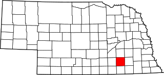
This is a list of the National Register of Historic Places listings in Kearney County, Nebraska. It is intended to be a complete list of the properties and districts on the National Register of Historic Places in Kearney County, Nebraska, United States. The locations of National Register properties and districts for which the latitude and longitude coordinates are included below, may be seen in an online map.

Champion Mill is a historic flour and feed mill in Champion, in the southwestern part of the state of Nebraska, in the Midwestern United States. Built in 1888 and rebuilt in 1892 after a fire, the mill was used commercially until 1968. It is now a museum and park run by Chase County preserving the state's last working water-powered mill. The mill, headrace, and dam were added to the National Register of Historic Places as a historic district in 1988.

This is a list of the National Register of Historic Places listings in Holt County, Nebraska. It is intended to be a complete list of the properties and districts on the National Register of Historic Places in Holt County, Nebraska, United States. The locations of National Register properties and districts for which the latitude and longitude coordinates are included below, may be seen in an online map.

This is a list of the National Register of Historic Places listings in Sioux County, Nebraska. It is intended to be a complete list of the properties and districts on the National Register of Historic Places in Sioux County, Nebraska, United States. The locations of National Register properties and districts for which the latitude and longitude coordinates are included below, may be seen in an online map.

The Texas Trail Stone Corral, near Imperial, Nebraska, was built in 1874 and is a rare surviving artifact of cattle drives along the Texas Trail. It is listed on the National Register of Historic Places and as a Nebraska historic resource, NeHBS no. CH00-041.

The Meisch House, also known as the Garlack House, was built in 1888 in Dakota County, Nebraska and was listed on the National Register of Historic Places in 1986.

Pinkie's Corner in Chase County, Nebraska was listed on the National Register of Historic Places in 2011. It is an example of an early rural auto roadside business.

The O'Neill United States Post Office was built in the 1930s. It is a one-story Georgian Revival style building built from standard plans. It was listed on the National Register of Historic Places in 1992.
The Texas Trail, better known as the Texas Road but also known as the Shawnee Trail, Sedalia Trail or the Kansas Trail, was a historic cattle trail which was used to drive cattle from Texas to Ogallala, Nebraska and other locations on the Union Pacific Railway in Nebraska. This emerged as an alternative to the Chisholm Trail which had brought cattle to Abilene, Kansas and other locations on the Kansas Pacific Railroad.

The Cedar Rapids City Hall and Library, in Cedar Rapids in Boone County, Nebraska, was built in 1913. It was listed on the National Register of Historic Places in 1994.

The Albion United States Post Office, also known as U.S. Post Office-Albion in Albion in Boone County, Nebraska, was built in 1939. It was listed on the National Register of Historic Places in 1992.
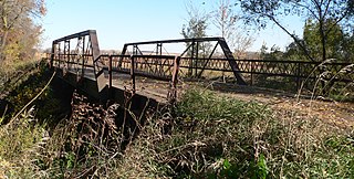
The Rattlesnake Creek Bridge brings a Cuming County, Nebraska county road over Rattlesnake Creek, 2.8 miles northwest of Bancroft. It was built in 1903 and was listed on the National Register of Historic Places in 1992.

The West Point City Auditorium in West Point in Cuming County, Nebraska was built in 1911. It was listed on the National Register of Historic Places in 2009.


