National Register of Historic Places listings in Cherokee County, Oklahoma

Last updated

Location of Cherokee County in Oklahoma Map of Oklahoma highlighting Cherokee County.svg
Location of Cherokee County in Oklahoma

This is a list of the National Register of Historic Places listings in Cherokee County, Oklahoma.

Contents

This is intended to be a complete list of the properties and districts on the National Register of Historic Places in Cherokee County, Oklahoma, United States. The locations of National Register properties and districts for which the latitude and longitude coordinates are included below, may be seen in a map. [1]

There are 21 properties and districts listed on the National Register in the county, including 2 National Historic Landmarks.


    This National Park Service list is complete through NPS recent listings posted March 4, 2022. [2]

Map all coordinates using: OpenStreetMap  
Download coordinates as: KML

Current listings

[3] Name on the Register [4] ImageDate listed [5] Location City or townDescription
1 Alston-Bedwell House
Alston-Bedwell House Alston-Bedwell House.JPG
Alston-Bedwell House
September 8, 2005
(#05001002)
315 N. State
35°55′00″N94°58′28″W / 35.916667°N 94.974444°W / 35.916667; -94.974444 (Alston-Bedwell House)
Tahlequah
2 American Baptist Home Mission House September 3, 2010
(#10000621)
530 Summit St.
35°55′10″N94°58′26″W / 35.919444°N 94.973889°W / 35.919444; -94.973889 (American Baptist Home Mission House)
Tahlequah
3 American Legion Hut
American Legion Hut American Legion Hut, Tahlequah, OK.JPG
American Legion Hut
August 24, 2006
(#06000798)
Tehlequah City Park, junction of E. Shawnee St. and N. Brookside Ave.
35°54′47″N94°58′03″W / 35.913056°N 94.9675°W / 35.913056; -94.9675 (American Legion Hut)
Tahlequah
4 Cherokee Female Seminary
Cherokee Female Seminary Seminary Hall.jpg
Cherokee Female Seminary
April 5, 1973
(#73001558)
Northeastern State University campus
35°55′13″N94°58′12″W / 35.920278°N 94.97°W / 35.920278; -94.97 (Cherokee Female Seminary)
Tahlequah
5 Cherokee National Capitol
Cherokee National Capitol Cherokee National Capitol.jpg
Cherokee National Capitol
October 15, 1966
(#66000627)
Eastern side of Muskogee Ave. between Keetoowah and Delaware Sts. [6]
35°54′45″N94°58′14″W / 35.9125°N 94.9706°W / 35.9125; -94.9706 (Cherokee National Capitol)
Tahlequah
6 Cherokee National Jail
Cherokee National Jail Cherokee National Jail.jpg
Cherokee National Jail
June 28, 1974
(#74001656)
Choctaw St. and Water Ave.
35°54′43″N94°58′02″W / 35.911944°N 94.967222°W / 35.911944; -94.967222 (Cherokee National Jail)
Tahlequah
7 Cherokee Supreme Court Building
Cherokee Supreme Court Building Cherokee Supreme Court Building.jpg
Cherokee Supreme Court Building
June 28, 1974
(#74001657)
Keetoowah St. and Water Ave.
35°54′47″N94°58′00″W / 35.913056°N 94.966667°W / 35.913056; -94.966667 (Cherokee Supreme Court Building)
Tahlequah
8 First Cherokee Female Seminary Site
First Cherokee Female Seminary Site First Cherokee Female Seminary.jpg
First Cherokee Female Seminary Site
April 30, 1974
(#74001658)
21191 S. Keeler Dr.
35°51′59″N94°57′11″W / 35.866389°N 94.953056°W / 35.866389; -94.953056 (First Cherokee Female Seminary Site)
Park Hill
9 M.E. Franklin House
M.E. Franklin House M.E. Franklin House.JPG
M.E. Franklin House
September 5, 2006
(#06000791)
415 N. College Ave.
35°55′03″N94°58′13″W / 35.9175°N 94.970278°W / 35.9175; -94.970278 (M.E. Franklin House)
Tahlequah
10 French-Parks House
French-Parks House French-Parks House.JPG
French-Parks House
March 18, 1985
(#85000618)
209 W. Keetoowah St.
35°54′45″N94°58′23″W / 35.9125°N 94.973056°W / 35.9125; -94.973056 (French-Parks House)
Tahlequah
11 Illinois Campground
Illinois Campground Illinois Campground, near Tahlequah, OK.JPG
Illinois Campground
December 6, 2004
(#04001330)
County Road DO775
35°53′42″N94°57′38″W / 35.895°N 94.960556°W / 35.895; -94.960556 (Illinois Campground)
Tahlequah
12 Indian University of Tahlequah
Indian University of Tahlequah Indian University of Tahlequah.JPG
Indian University of Tahlequah
July 6, 1976
(#76001557)
320 Academy
35°55′05″N94°58′20″W / 35.918056°N 94.972222°W / 35.918056; -94.972222 (Indian University of Tahlequah)
Tahlequah
13 Dr. Irwin D. Loeser Log Cabin
Dr. Irwin D. Loeser Log Cabin Dr. Irwin D. Loeser Log Cabin.jpg
Dr. Irwin D. Loeser Log Cabin
November 17, 1978
(#78002221)
121 E. Smith St.
35°55′05″N94°58′02″W / 35.918056°N 94.967222°W / 35.918056; -94.967222 (Dr. Irwin D. Loeser Log Cabin)
Tahlequah
14 Leonard M. Logan House October 12, 2005
(#05001165)
531 Summit
35°55′08″N94°58′26″W / 35.918889°N 94.973889°W / 35.918889; -94.973889 (Leonard M. Logan House)
Tahlequah
15 Murrell Home
Murrell Home George M. Murrell House, Murrell Road, at junction of Willis Road, Park Hill vicinity (Cherokee County, Oklahoma).jpg
Murrell Home
June 22, 1970
(#70000530)
19479 East Murrel Road
35°50′57″N94°57′51″W / 35.849167°N 94.964167°W / 35.849167; -94.964167 (Murrell Home)
Park Hill
16 Park Hill Mission Cemetery
Park Hill Mission Cemetery Park Hill Mission Cemetery.JPG
Park Hill Mission Cemetery
December 6, 2006
(#06001113)
South Park Hill Rd., 0.5 miles south of East Murrell Rd.
35°50′58″N94°57′57″W / 35.849444°N 94.965833°W / 35.849444; -94.965833 (Park Hill Mission Cemetery)
Park Hill
17 Rosamund
Rosamund Rosamund.JPG
Rosamund
September 6, 2006
(#06000793)
527 Seminary Ave.
35°55′05″N94°58′14″W / 35.918056°N 94.970556°W / 35.918056; -94.970556 (Rosamund)
Tahlequah
18 Ross Cemetery
Ross Cemetery Ross Cemetery.JPG
Ross Cemetery
March 7, 2002
(#02000170)
0.5 miles south of the junction of Murrell Rd. and N4530 Rd.
35°51′03″N94°56′53″W / 35.850833°N 94.948056°W / 35.850833; -94.948056 (Ross Cemetery)
Park Hill
19 Tahlequah Armory
Tahlequah Armory Tahlequah Armory.JPG
Tahlequah Armory
May 20, 1994
(#94000488)
100 Water Ave.
35°54′47″N94°58′08″W / 35.913056°N 94.968889°W / 35.913056; -94.968889 (Tahlequah Armory)
Tahlequah
20 Tahlequah Carnegie Library
Tahlequah Carnegie Library Tahlequah Carnegie Library.JPG
Tahlequah Carnegie Library
June 5, 2003
(#03000516)
120 S. College
35°54′48″N94°58′22″W / 35.913333°N 94.972778°W / 35.913333; -94.972778 (Tahlequah Carnegie Library)
Tahlequah
21 Joseph M. Thompson House
Joseph M. Thompson House Joseph M. Thompson House.JPG
Joseph M. Thompson House
March 11, 1993
(#93000155)
300 S. College Ave.
35°54′48″N94°58′33″W / 35.913333°N 94.975833°W / 35.913333; -94.975833 (Joseph M. Thompson House)
Tahlequah

See also

Related Research Articles

National Register of Historic Places listings in Lancaster County, Pennsylvania

This is a list of the National Register of Historic Places listings in Lancaster County, Pennsylvania.

National Register of Historic Places listings in Fayette County, Pennsylvania

This is a list of the National Register of Historic Places listings in Fayette County, Pennsylvania.

National Register of Historic Places listings in York County, Pennsylvania

This is a list of the National Register of Historic Places listings in York County, Pennsylvania.

National Register of Historic Places listings in Cuyahoga County, Ohio

This is a list of the National Register of Historic Places listings in Cuyahoga County, Ohio.

National Register of Historic Places listings in Dauphin County, Pennsylvania

This is a list of the National Register of Historic Places listings in Dauphin County, Pennsylvania.

National Register of Historic Places listings in Alachua County, Florida

This is a list of the National Register of Historic Places listings in Alachua County, Florida.

National Register of Historic Places listings in Delaware County, Ohio

This is a list of the National Register of Historic Places listings in Delaware County, Ohio.

National Register of Historic Places listings in Fairfield County, Ohio

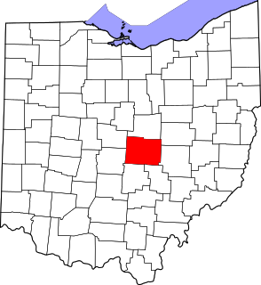
This is a list of the National Register of Historic Places listings in Fairfield County, Ohio.

National Register of Historic Places listings in Licking County, Ohio

This is a list of the National Register of Historic Places listings in Licking County, Ohio.

National Register of Historic Places listings in Warren County, Ohio

This is a list of the National Register of Historic Places listings in Warren County, Ohio.

National Register of Historic Places listings in Greene County, Ohio

This is a list of the National Register of Historic Places listings in Greene County, Ohio.

National Register of Historic Places listings in Adams County, Ohio

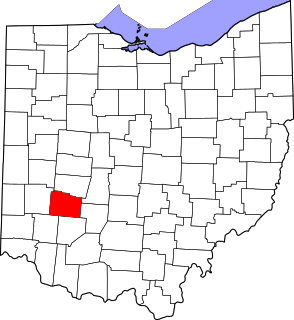
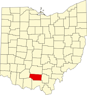
This is a list of the National Register of Historic Places listings in Adams County, Ohio.

National Register of Historic Places listings in San Bernardino County, California

This is a list of the National Register of Historic Places listings in San Bernardino County, California.

National Register of Historic Places listings in Centre County, Pennsylvania

This is a list of the National Register of Historic Places listings in Centre County, Pennsylvania.

National Register of Historic Places listings in Marion County, Ohio

This is a list of the National Register of Historic Places listings in Marion County, Ohio.

National Register of Historic Places listings in Hocking County, Ohio

This is a list of the National Register of Historic Places listings in Hocking County, Ohio.

National Register of Historic Places listings in Le Flore County, Oklahoma

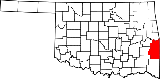
This is a list of the National Register of Historic Places listings in Le Flore County, Oklahoma.

National Register of Historic Places listings in Kiowa County, Oklahoma

This is a list of the National Register of Historic Places listings in Kiowa County, Oklahoma.

National Register of Historic Places listings in Henry County, Indiana

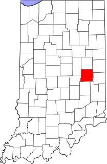
This is a list of the National Register of Historic Places listings in Henry County, Indiana.

National Register of Historic Places listings in Pike County, Ohio

This is a list of the National Register of Historic Places listings in Pike County, Ohio.

References

  1. The latitude and longitude information provided in this table was derived originally from the National Register Information System, which has been found to be fairly accurate for about 99% of listings. Some locations in this table may have been corrected to current GPS standards.
  2. National Park Service, United States Department of the Interior, "National Register of Historic Places: Weekly List Actions", retrieved March 4, 2022.
  3. Numbers represent an alphabetical ordering by significant words. Various colorings, defined here, differentiate National Historic Landmarks and historic districts from other NRHP buildings, structures, sites or objects.
  4. "National Register Information System". National Register of Historic Places . National Park Service. March 13, 2009.
  5. The eight-digit number below each date is the number assigned to each location in the National Register Information System database, which can be viewed by clicking the number.
  6. Address derived from the coordinates provided by the NRIS; the NRIS lists the building as "Address Restricted"