National Register of Historic Places listings in Clackamas County, Oregon
Last updated
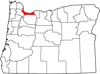
Location of Clackamas County in Oregon
This list presents the full set of buildings, structures, objects, sites, or districts designated on the National Register of Historic Places in Clackamas County, Oregon, and offers brief descriptive information about each of them. The National Register recognizes places of national, state, or local historic significance across the United States.[1] Out of over 90,000 National Register sites nationwide,[2]Oregon is home to over 2,000,[3] and 91 of those are found partially or wholly in Clackamas County.
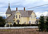
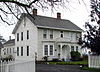
John C. Ainsworth (1822–1893), businessman and co-founder of the Oregon Steam Navigation Company, built this house in 1851, where he lived until Portland supplanted Oregon City as the commercial center of the Northwest. Its monumental Neoclassical design and imposing two-story, pillared portico made it unique in its period.[8]
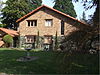
Dr. Barclay built this house in 1849, after retiring from 10 years as a physician with the Hudson's Bay Company at Fort Vancouver. In Oregon City, he continued medical practice as well as holding a variety of public offices. The house was moved from its original location to its present address in the 1930s.[9]
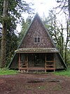
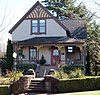
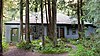
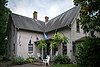
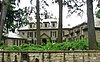
This is the fourth and final residence designed by architect Wade Pipes (1877–1961) for his friends John and Elizabeth Bates, and the penultimate and finest commission of his career. In it, Pipes designed not only the building but also the landscape, furnishings, and interior finishes, representing the culmination of his work as a pivotal figure in the Arts and Crafts movement in Oregon.[12]
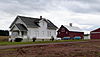
Established at the upper end of the Willamette Fallsportage, Canemah became a transportation hub and center of steamboatconstruction and river shipping in a period (about 1850–1878) when these industries were critical to the Oregon economy. It retained much of its 19th-century character as it developed into a residential neighborhood of Oregon City by the late 20th century.[13]
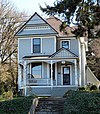
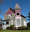
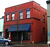
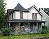
This stately house, built in the late 1880s, is one of the finest examples of Italianate residential architecture in Oregon City. It was built for prominent citizen Harvey Cross, a county judge and state senator, investor in real estate and transportation infrastructure,[lower-alpha 2] and promoter of the Chautauqua movement in Oregon.[14]
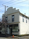
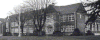
This house, completed in 1964, is a locally significant and almost unaltered example of the Contemporary Style of the late 1950s and early 1960s. Designer/builder John Kinsman built the house for himself and his wife Elizabeth using design elements characteristic of his other projects.[15]
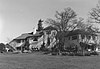
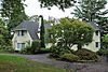
Dr. John McLoughlin, known as the "Father of Oregon" for the support he provided to emigrants on the Oregon Trail, built this house in 1846 upon his retirement from 20 years as Chief Factor of the Hudson's Bay Company's Fort Vancouver. In retirement, he continued his activities as mayor of Oregon City, a private businessman, and philanthropist. The house was moved from its original location beside the Willamette River to its current blufftop site in 1909.[19]
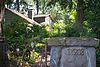
This erratic boulder was a well-recognized landmark and frequent campsite along the final stages of the Oregon Trail after emigrants crossed the Cascades on the Barlow Road. With time, a semi-permanent wooden corral was built around "the Rock". Reaching the Rock Corral signaled to emigrants that their long journey was almost over, and the most difficult stretches were passed.[21]
↑ The Barlow Road is a linear district that runs north of and roughly parallel to the line of the White and Salmon rivers from southwest of Wamic to Rhododendron. See also Wasco and Hood River counties.
↑ Cross most notably invested in the real estate development that became the city of Gladstone and in the Barlow Road.
↑ The Willamette Historic District was originally entered on the National Register as the Willamette Falls Neighborhood Historic District. The name was changed in 2013.
Related Research Articles
The following list presents the full set of National Register of Historic Places listings in Multnomah County, Oregon. However, please see separate articles for listings in each of Portland's six quadrants.
This is a list of the National Register of Historic Places listings in Otter Tail County, Minnesota. It is intended to be a complete list of the properties and districts on the National Register of Historic Places in Otter Tail County, Minnesota, United States. The locations of National Register properties and districts for which the latitude and longitude coordinates are included below, may be seen in an online map.
This is a list of the National Register of Historic Places listings in Swift County, Minnesota. It is intended to be a complete list of the properties and districts on the National Register of Historic Places in Swift County, Minnesota, United States. The locations of National Register properties and districts for which the latitude and longitude coordinates are included below, may be seen in an online map.
↑ Oregon Parks and Recreation Department, Oregon Historic Sites Database, retrieved August 6, 2015. Note that a simple count of National Register records in this database returns a slightly higher total than actual listings, due to duplicate records. A close reading of detailed query results is necessary to arrive at the precise count.
1 2 Numbers represent an alphabetical ordering by significant words. Various colorings, defined here, differentiate National Historic Landmarks and historic districts from other NRHP buildings, structures, sites or objects.
↑ The eight-digit number below each date is the number assigned to each location in the National Register Information System database, which can be viewed by clicking the number.
↑ Clackamas Heritage Partners (February 1, 2013), "Final Leg", Historic Oregon City, archived from the original on August 10, 2014, retrieved July 23, 2014.
This page is based on this Wikipedia article Text is available under the CC BY-SA 4.0 license; additional terms may apply. Images, videos and audio are available under their respective licenses.