National Register of Historic Places listings in Duplin County, North Carolina

Last updated

Map all coordinates using: OpenStreetMap  
Download coordinates as: KML
North Carolina Map Highlighting Duplin County.PNG

This list includes properties and districts listed on the National Register of Historic Places in Duplin County, North Carolina. Click the "Map of all coordinates" link to the right to view a Google map of all properties and districts with latitude and longitude coordinates in the table below. [1]

Contents

Current listings


    This National Park Service list is complete through NPS recent listings posted July 1, 2022. [2]

[3] Name on the RegisterImageDate listed [4] Location City or townDescription
1 Joshua James Blanchard House
Joshua James Blanchard House Joshua James Blanchard House in Warsaw, NC.jpg
Joshua James Blanchard House
August 28, 2012
(#12000572)
415 Carrolls Rd.
34°58′31″N78°09′03″W / 34.975316°N 78.150925°W / 34.975316; -78.150925 (Joshua James Blanchard House)
Warsaw
2 W. Stokes Boney House July 8, 1999
(#99000812)
651 E. Southerland St.
34°44′31″N77°59′09″W / 34.741944°N 77.985833°W / 34.741944; -77.985833 (W. Stokes Boney House)
Wallace
3 Carter-Simmons House
Carter-Simmons House Carter-Simmonns House post-stabilization.jpg
Carter-Simmons House
April 15, 2015
(#15000162)
218 Coy Smith Rd.
35°05′48″N77°48′27″W / 35.0966°N 77.8074°W / 35.0966; -77.8074 (Carter-Simmons House)
Albertson
4 Roger Dickson Farm February 8, 1988
(#88000053)
E side of SR 1917
34°51′42″N78°00′28″W / 34.861667°N 78.007778°W / 34.861667; -78.007778 (Roger Dickson Farm)
Magnolia
5 Faison Cemetery
Faison Cemetery Faison Cemetery.jpg
Faison Cemetery
April 19, 2006
(#06000291)
East Main St. (NC 403)
35°06′59″N78°07′54″W / 35.116389°N 78.131667°W / 35.116389; -78.131667 (Faison Cemetery)
Faison
6 Faison Historic District
Faison Historic District Main east of Faison.jpg
Faison Historic District
January 2, 1997
(#96001550)
Roughly bounded by College, Hill, Solomon, and Ellis Sts.
35°07′00″N78°08′16″W / 35.116667°N 78.137778°W / 35.116667; -78.137778 (Faison Historic District)
Faison
7 William Wright Faison House December 23, 2004
(#04001390)
NC 1304, 0.2 miles (0.32 km) southeast of the junction with NC 1354
35°04′51″N78°03′35″W / 35.080833°N 78.059722°W / 35.080833; -78.059722 (William Wright Faison House)
Bowdens
8 B. F. Grady School February 24, 1994
(#94000085)
North side NC 11, 0.3 miles (0.48 km) west of the junction with NC 111
35°03′20″N77°49′54″W / 35.055556°N 77.831667°W / 35.055556; -77.831667 (B. F. Grady School)
Kornegay Destroyed April 1996 [5]
9 Hebron Presbyterian Church February 24, 1995
(#95000144)
NC 1551 northwest side, 0.15 miles (0.24 km) northeast of the junction with NC 1554
35°03′44″N77°46′57″W / 35.062222°N 77.7825°W / 35.062222; -77.7825 (Hebron Presbyterian Church)
Pink Hill
10 Bryan Whitfield Herring Farm November 29, 2001
(#01001315)
NC 1311, 1 mile (1.6 km) east of the junction with NC 1302
35°09′57″N78°07′37″W / 35.165833°N 78.126944°W / 35.165833; -78.126944 (Bryan Whitfield Herring Farm)
Calypso
11 Needham Whitfield Herring House May 26, 1994
(#94000529)
201 NC 24-50
34°57′28″N77°58′51″W / 34.957778°N 77.980833°W / 34.957778; -77.980833 (Needham Whitfield Herring House)
Kenansville
12 Buckner Hill House December 6, 1975
(#75001255)
Southeast of Faison on SR 1354
35°05′00″N78°05′13″W / 35.083333°N 78.086944°W / 35.083333; -78.086944 (Buckner Hill House)
Faison
13 Kenansville Historic District
Kenansville Historic District Liberty Hall Restoration.jpg
Kenansville Historic District
March 13, 1975
(#75001256)
Downtown area centered around Main St. and Limestone Rd. as far N as Hill St.
34°57′38″N77°57′47″W / 34.960556°N 77.963056°W / 34.960556; -77.963056 (Kenansville Historic District)
Kenansville
14 Loftin Farm December 31, 2001
(#01001426)
NC 1368, 0.65 miles (1.05 km) south of the junction with NC 1367
35°09′15″N78°01′28″W / 35.154167°N 78.024444°W / 35.154167; -78.024444 (Loftin Farm)
Beautancus
15 John Wesley Mallard House
John Wesley Mallard House John Wesley Mallard House.jpg
John Wesley Mallard House
December 23, 2004
(#04001391)
NC 1301, 0.25 miles (0.40 km) south of NC 1329
35°06′36″N78°08′56″W / 35.110000°N 78.148889°W / 35.110000; -78.148889 (John Wesley Mallard House)
Faison
16 Isaac M. Powers House April 15, 1999
(#99000461)
NC 1154, 0.8 miles (1.3 km) south of the junction of NC 1154 and NC 4
34°44′01″N78°02′01″W / 34.733611°N 78.033611°W / 34.733611; -78.033611 (Isaac M. Powers House)
Wallace
17 Wallace Commercial Historic District October 20, 1995
(#95001179)
Roughly bounded by Southerland, College, Boney and Raleigh Sts.
34°44′08″N77°59′35″W / 34.735556°N 77.993056°W / 34.735556; -77.993056 (Wallace Commercial Historic District)
Wallace
18 Warsaw Historic District
Warsaw Historic District Warsaw HD, Front south of Plank.jpg
Warsaw Historic District
December 13, 1996
(#96001484)
Roughly bounded by former Atlantic Coastline RR right-of-way, N. and S. Front, Pollock, Frisco, Plank, and Railroad Sts.
34°59′58″N78°05′37″W / 34.999444°N 78.093611°W / 34.999444; -78.093611 (Warsaw Historic District)
Warsaw
19 Waterloo January 8, 1975
(#75001254)
2 miles (3.2 km) south of Albertson on NC 111
35°05′12″N77°48′55″W / 35.086667°N 77.815278°W / 35.086667; -77.815278 (Waterloo)
Albertson

See also

Related Research Articles

National Register of Historic Places listings in Franklin County, North Carolina

This list includes properties and districts listed on the National Register of Historic Places in Franklin County, North Carolina. Click the "Map of all coordinates" link to the right to view an online map of all properties and districts with latitude and longitude coordinates in the table below.

National Register of Historic Places listings in Lincoln County, North Carolina

This list includes properties and districts listed on the National Register of Historic Places in Lincoln County, North Carolina. Click the "Map of all coordinates" link to the right to view an online map of all properties and districts with latitude and longitude coordinates in the table below.

National Register of Historic Places listings in Bertie County, North Carolina

This list includes properties and districts listed on the National Register of Historic Places in Bertie County, North Carolina. Click the "Map of all coordinates" link to the right to view an online map of all properties and districts with latitude and longitude coordinates in the table below.

National Register of Historic Places listings in Perquimans County, North Carolina

This list includes properties and districts listed on the National Register of Historic Places in Perquimans County, North Carolina. Click the "Map of all coordinates" link to the right to view a Google map of all properties and districts with latitude and longitude coordinates in the table below.

National Register of Historic Places listings in Surry County, North Carolina

This list includes properties and districts listed on the National Register of Historic Places in Surry County, North Carolina, United States. Click the "Map of all coordinates" link to the right to view an online map of all properties and districts with latitude and longitude coordinates in the table below.

National Register of Historic Places listings in Richmond County, North Carolina

This list includes properties and districts listed on the National Register of Historic Places in Richmond County, North Carolina. Click the "Map of all coordinates" link to the right to view a Google map of all properties and districts with latitude and longitude coordinates in the table below.

National Register of Historic Places listings in Davie County, North Carolina

This list includes properties and districts listed on the National Register of Historic Places in Davie County, North Carolina. Click the "Map of all coordinates" link to the right to view a Google map of all properties and districts with latitude and longitude coordinates in the table below.

National Register of Historic Places listings in Onslow County, North Carolina

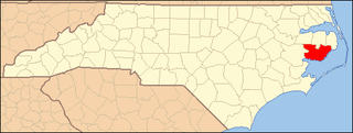
This list includes properties and districts listed on the National Register of Historic Places in Onslow County, North Carolina. Click the "Map of all coordinates" link to the right to view a Google map of all properties and districts with latitude and longitude coordinates in the table below.

National Register of Historic Places listings in Northampton County, North Carolina

This list includes properties and districts listed on the National Register of Historic Places in Northampton County, North Carolina. Click the "Map of all coordinates" link to the right to view an online map of all properties and districts with latitude and longitude coordinates in the table below.

National Register of Historic Places listings in Anson County, North Carolina

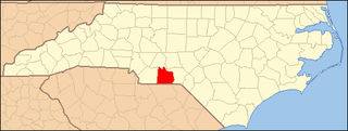
This list includes properties and districts listed on the National Register of Historic Places in Anson County, North Carolina. Click the "Map of all coordinates" link to the right to view a Google map of all properties and districts with latitude and longitude coordinates in the table below.

National Register of Historic Places listings in Jones County, North Carolina

This list includes properties and districts listed on the National Register of Historic Places in Jones County, North Carolina. Click the "Map of all coordinates" link to the right to view a Google map of all properties and districts with latitude and longitude coordinates in the table below.

National Register of Historic Places listings in Mitchell County, North Carolina

This list includes properties and districts listed on the National Register of Historic Places in Mitchell County, North Carolina. Click the "Map of all coordinates" link to the right to view a Google map of all properties and districts with latitude and longitude coordinates in the table below.

National Register of Historic Places listings in Tyrrell County, North Carolina

This list includes properties and districts listed on the National Register of Historic Places in Tyrrell County, North Carolina. Click the "Map of all coordinates" link to the right to view a Google map of all properties and districts with latitude and longitude coordinates in the table below.

National Register of Historic Places listings in Camden County, North Carolina

This list includes properties and districts listed on the National Register of Historic Places in Camden County, North Carolina. Click the "Map of all coordinates" link to the right to view an online map of all properties and districts with latitude and longitude coordinates in the table below.

National Register of Historic Places listings in Hoke County, North Carolina

This list includes properties and districts listed on the National Register of Historic Places in Hoke County, North Carolina. Click the "Map of all coordinates" link to the right to view a Google map of all properties and districts with latitude and longitude coordinates in the table below.

National Register of Historic Places listings in Hyde County, North Carolina

This list includes properties and districts listed on the National Register of Historic Places in Hyde County, North Carolina. Click the "Map of all coordinates" link to the right to view a Google map of all properties and districts with latitude and longitude coordinates in the table below.

National Register of Historic Places listings in McDowell County, North Carolina

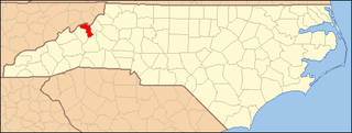
This list includes properties and districts listed on the National Register of Historic Places in McDowell County, North Carolina. Click the "Map of all coordinates" link to the right to view a Google map of all properties and districts with latitude and longitude coordinates in the table below.

National Register of Historic Places listings in Pamlico County, North Carolina

This list includes properties and districts listed on the National Register of Historic Places in Pamlico County, North Carolina. Click the "Map of all coordinates" link to the right to view a Google map of all properties and districts with latitude and longitude coordinates in the table below.

National Register of Historic Places listings in Washington County, North Carolina

This list includes properties and districts listed on the National Register of Historic Places in Washington County, North Carolina. Click the "Map of all coordinates" link to the right to view a Google map of all properties and districts with latitude and longitude coordinates in the table below.

National Register of Historic Places listings in Yancey County, North Carolina

This list includes properties and districts listed on the National Register of Historic Places in Yancey County, North Carolina. Click the "Map of all coordinates" link to the right to view a Google map of all properties and districts with latitude and longitude coordinates in the table below.

References

  1. The latitude and longitude information provided in this table was derived originally from the National Register Information System, which has been found to be fairly accurate for about 99% of listings. Some locations in this table may have been corrected to current GPS standards.
  2. National Park Service, United States Department of the Interior, "National Register of Historic Places: Weekly List Actions", retrieved July 1, 2022.
  3. Numbers represent an alphabetical ordering by significant words. Various colorings, defined here, differentiate National Historic Landmarks and historic districts from other NRHP buildings, structures, sites or objects.
  4. The eight-digit number below each date is the number assigned to each location in the National Register Information System database, which can be viewed by clicking the number.
  5. "North Carolina Listings in the National Register of Historic Places by County". North Carolina State Historic Preservation Office. 22 October 2008. Archived from the original on 30 November 2012. Retrieved 14 July 2009.