[3] Name on the Register [4] Image Date listed [5] Location City or town Description 1 310 West Church Street Apartments 310 West Church Street Apartments April 7, 1983 (# 83001421 420 North Julia Street 30°19′50″N 81°39′41″W / 30.330556°N 81.661389°W / 30.330556; -81.661389 (310 West Church Street Apartments ) Jacksonville Formerly the Ambassador Hotel 2 American Red Cross Volunteer Life Saving Corps Station American Red Cross Volunteer Life Saving Corps Station May 5, 2014 (# 14000187 2 Ocean Front North 30°17′22″N 81°23′23″W / 30.2894791°N 81.3897182°W / 30.2894791; -81.3897182 (American Red Cross Volunteer Life Saving Corps Station ) Jacksonville Beach 3 Henry C. Arpen House Henry C. Arpen House August 26, 2019 (# 100004347 3318 O'Connor Road 30°08′50″N 81°37′07″W / 30.1471°N 81.6186°W / 30.1471; -81.6186 (Henry C. Arpen House ) Jacksonville 4 Atlantic Coast Line Railroad Locomotive No. 1504 Atlantic Coast Line Railroad Locomotive No. 1504 January 23, 2018 (# 100001388 1000 West Bay St. 30°19′43″N 81°40′17″W / 30.328488°N 81.671486°W / 30.328488; -81.671486 (Atlantic Coast Line Railroad Locomotive No. 1504 ) Jacksonville 5 Atlantic National Bank Annex Atlantic National Bank Annex November 7, 1997 (# 97001328 118 West Adams Street 30°19′40″N 81°39′36″W / 30.327778°N 81.66°W / 30.327778; -81.66 (Atlantic National Bank Annex ) Jacksonville Part of the Downtown Jacksonville Multiple Property Submission 6 Avondale Historic District Avondale Historic District July 6, 1989 (# 89000494 Roughly bounded by Roosevelt Boulevard, Belvedere Avenue, Seminole Road, the St. Johns River , and Talbot Avenue 30°18′11″N 81°42′19″W / 30.303056°N 81.705278°W / 30.303056; -81.705278 (Avondale Historic District ) Jacksonville 7 Bethel Baptist Institutional Church Bethel Baptist Institutional Church April 6, 1978 (# 78000938 1058 Hogan Street 30°20′09″N 81°39′30″W / 30.335833°N 81.658333°W / 30.335833; -81.658333 (Bethel Baptist Institutional Church ) Jacksonville 8 Brewster Hospital Brewster Hospital May 13, 1976 (# 76000588 843 West Monroe Street 30°19′52″N 81°40′08″W / 30.331111°N 81.668889°W / 30.331111; -81.668889 (Brewster Hospital ) Jacksonville 9 Napoleon Bonaparte Broward House Napoleon Bonaparte Broward House December 27, 1972 (# 72000308 9953 Hecksher Drive 30°24′09″N 81°25′58″W / 30.4025°N 81.432778°W / 30.4025; -81.432778 (Napoleon Bonaparte Broward House ) Jacksonville 10 Carling Hotel Carling Hotel February 28, 1991 (# 91000225 33 West Adams Street 30°19′42″N 81°39′29″W / 30.328333°N 81.658056°W / 30.328333; -81.658056 (Carling Hotel ) Jacksonville 11 Casa Marina Hotel Casa Marina Hotel September 2, 1993 (# 93000893 12 Sixth Avenue, North 30°17′40″N 81°23′26″W / 30.294444°N 81.390556°W / 30.294444; -81.390556 (Casa Marina Hotel ) Jacksonville Beach 12 Centennial Hall at Edward Waters College Centennial Hall at Edward Waters College May 4, 1976 (# 76000589 1715 Kings Road [6] 30°20′40″N 81°41′04″W / 30.344444°N 81.684444°W / 30.344444; -81.684444 (Centennial Hall at Edward Waters College ) Jacksonville 13 Church of the Immaculate Conception Church of the Immaculate Conception December 30, 1992 (# 92001695 121 East Duval Street 30°19′44″N 81°39′19″W / 30.328889°N 81.655278°W / 30.328889; -81.655278 (Church of the Immaculate Conception ) Jacksonville Part of the Downtown Jacksonville Multiple Property Submission 14 Clifton Cemetery Upload image April 15, 2022 (# 100007617 Intersection of Garrison and Magnolia Bluff Aves 30°19′20″N 81°36′34″W / 30.322291°N 81.609311°W / 30.322291; -81.609311 (Clifton Cemetery ) Jacksonville 15 Cummer Gardens Cummer Gardens January 25, 2010 (# 09000345 829 Riverside Ave. 30°18′54″N 81°40′37″W / 30.315°N 81.67687°W / 30.315; -81.67687 (Cummer Gardens ) Jacksonville 16 Downtown Jacksonville Historic District Downtown Jacksonville Historic District May 2, 2016 (# 16000212 Roughly bounded by North Pearl, Beaver, and North Catherine Streets, and Independent/Courthouse Drives 30°19′45″N 81°39′26″W / 30.329153°N 81.657217°W / 30.329153; -81.657217 (Downtown Jacksonville Historic District ) Jacksonville 17 Durkee Gardens Historic District Durkee Gardens Historic District March 16, 2020 (# 100005088 Bound by Myrtle Ave., 13th St. West, Payne Ave, Wilcox St. and 8th St. West 30°20′56″N 81°40′23″W / 30.3490°N 81.6731°W / 30.3490; -81.6731 (Durkee Gardens Historic District ) Jacksonville 18 Duval County Armory Duval County Armory July 27, 2023 (# 100009203 851 North Market St. 30°19′57″N 81°39′06″W / 30.3324°N 81.6517°W / 30.3324; -81.6517 (Duval County Armory ) Jacksonville 19 Joseph H. Durkee Athletic Field Joseph H. Durkee Athletic Field July 11, 2013 (# 13000484 1701 Myrtle Avenue 30°20′47″N 81°40′30″W / 30.346389°N 81.675°W / 30.346389; -81.675 (Joseph H. Durkee Athletic Field ) Jacksonville 20 Dyal-Upchurch Building Dyal-Upchurch Building April 17, 1980 (# 80000947 4 East Bay Street 30°19′33″N 81°39′27″W / 30.325833°N 81.6575°W / 30.325833; -81.6575 (Dyal-Upchurch Building ) Jacksonville 21 Eastside Historic District Upload image July 3, 2023 (# 100009081 Roughly bounded by East 7th St., MLK Jr. Pkwy, Arlington Expy, and Cemetery St. 30°20′11″N 81°38′29″W / 30.336467°N 81.641448°W / 30.336467; -81.641448 (Eastside Historic District ) Jacksonville Part of the African American Architects in Segregated Jacksonville, 1865-1965 MPS 22 Edward Waters College Historic District Edward Waters College Historic District August 8, 2022 (# 100007972 1658 Kings Rd. 30°20′37″N 81°41′01″W / 30.343713°N 81.683688°W / 30.343713; -81.683688 (Edward Waters College Historic District ) Jacksonville 23 El Modelo Block El Modelo Block October 16, 1980 (# 80000948 513 West Bay Street 30°19′38″N 81°39′53″W / 30.327222°N 81.664722°W / 30.327222; -81.664722 (El Modelo Block ) Jacksonville 24 Elks Club Building Elks Club Building March 9, 2000 (# 00000151 201-213 North Laura Street 30°19′41″N 81°39′32″W / 30.32818°N 81.6588°W / 30.32818; -81.6588 (Elks Club Building ) Jacksonville Part of the Downtown Jacksonville Multiple Property Submission 25 Epping Forest Epping Forest May 9, 1973 (# 73000576 Christopher Point, off San Jose Boulevard 30°14′54″N 81°38′26″W / 30.248333°N 81.640556°W / 30.248333; -81.640556 (Epping Forest ) Jacksonville 26 Evergreen Cemetery Evergreen Cemetery April 8, 2011 (# 11000157 4535 N Main St 30°22′01″N 81°39′03″W / 30.366944°N 81.650833°W / 30.366944; -81.650833 (Evergreen Cemetery ) Jacksonville 27 Florida Baptist Building Florida Baptist Building January 12, 1984 (# 84000844 218 West Church Street 30°19′49″N 81°39′37″W / 30.330278°N 81.660278°W / 30.330278; -81.660278 (Florida Baptist Building ) Jacksonville 28 Florida Theater Florida Theater November 4, 1982 (# 82001034 128-134 East Forsyth Street 30°19′35″N 81°39′20″W / 30.32628°N 81.65563°W / 30.32628; -81.65563 (Florida Theater ) Jacksonville 29 Fort Caroline National Memorial Fort Caroline National Memorial October 15, 1966 (# 66000061 10 miles east of downtown Jacksonville 30°23′13″N 81°30′02″W / 30.386944°N 81.500556°W / 30.386944; -81.500556 (Fort Caroline National Memorial ) Jacksonville 30 Garden Club of Jacksonville Upload image April 20, 2023 (# 100008872 1005 Riverside Ave. 30°18′50″N 81°40′39″W / 30.313902°N 81.677418°W / 30.313902; -81.677418 (Garden Club of Jacksonville ) Jacksonville 31 Grand Site Upload image June 20, 1975 (# 75000551 Address Restricted Jacksonville 32 Groover-Stewart Drug Company Building Groover-Stewart Drug Company Building December 30, 1992 (# 92001696 25 North Market Street 30°19′33″N 81°38′08″W / 30.325833°N 81.635556°W / 30.325833; -81.635556 (Groover-Stewart Drug Company Building ) Jacksonville Part of the Downtown Jacksonville Multiple Property Submission 33 House at 3325 Via de la Reina House at 3325 Via de la Reina April 10, 1985 (# 85000739 3325 Via de la Reina 30°14′42″N 81°37′41″W / 30.245°N 81.628056°W / 30.245; -81.628056 (House at 3325 Via de la Reina ) Jacksonville Part of the San Jose Estates TR 34 House at 3335 Via de la Reina House at 3335 Via de la Reina April 10, 1985 (# 85000740 3335 Via de la Reina 30°14′42″N 81°37′40″W / 30.245°N 81.627778°W / 30.245; -81.627778 (House at 3335 Via de la Reina ) Jacksonville Part of the San Jose Estates TR 35 House at 3500 Via de la Reina House at 3500 Via de la Reina April 10, 1985 (# 85000741 3500 Via de la Reina 30°14′39″N 81°37′32″W / 30.244167°N 81.625556°W / 30.244167; -81.625556 (House at 3500 Via de la Reina ) Jacksonville Part of the San Jose Estates TR 36 House at 3609 Via de la Reina House at 3609 Via de la Reina April 10, 1985 (# 85000742 3609 Via de la Reina 30°14′39″N 81°37′28″W / 30.244167°N 81.624444°W / 30.244167; -81.624444 (House at 3609 Via de la Reina ) Jacksonville Part of the San Jose Estates TR 37 House at 3685 Via de la Reina House at 3685 Via de la Reina April 10, 1985 (# 85000743 3685 Via de la Reina 30°14′34″N 81°37′14″W / 30.242778°N 81.620556°W / 30.242778; -81.620556 (House at 3685 Via de la Reina ) Jacksonville Part of the San Jose Estates TR 38 House at 3703 Via de la Reina House at 3703 Via de la Reina April 10, 1985 (# 85000744 3703 Via de la Reina 30°14′32″N 81°37′06″W / 30.242222°N 81.618333°W / 30.242222; -81.618333 (House at 3703 Via de la Reina ) Jacksonville Part of the San Jose Estates TR 39 House at 3764 Ponce de Leon Avenue House at 3764 Ponce de Leon Avenue April 10, 1985 (# 85000745 3764 Ponce de Leon Avenue 30°14′38″N 81°37′13″W / 30.243889°N 81.620278°W / 30.243889; -81.620278 (House at 3764 Ponce de Leon Avenue ) Jacksonville Part of the San Jose Estates TR 40 House at 7144 Madrid Avenue House at 7144 Madrid Avenue April 10, 1985 (# 85000746 7144 Madrid Avenue 30°14′53″N 81°37′54″W / 30.248056°N 81.631667°W / 30.248056; -81.631667 (House at 7144 Madrid Avenue ) Jacksonville Part of the San Jose Estates TR 41 House at 7207 Ventura Avenue House at 7207 Ventura Avenue April 10, 1985 (# 85000747 7207 Ventura Avenue 30°14′48″N 81°37′36″W / 30.246667°N 81.626667°W / 30.246667; -81.626667 (House at 7207 Ventura Avenue ) Jacksonville Part of the San Jose Estates TR 42 House at 7217 Ventura Avenue House at 7217 Ventura Avenue April 10, 1985 (# 85000748 7217 Ventura Avenue 30°14′46″N 81°37′36″W / 30.246111°N 81.626667°W / 30.246111; -81.626667 (House at 7217 Ventura Avenue ) Jacksonville Part of the San Jose Estates TR 43 House at 7227 San Pedro House at 7227 San Pedro April 10, 1985 (# 85000749 7227 San Pedro Road 30°14′41″N 81°37′57″W / 30.244722°N 81.6325°W / 30.244722; -81.6325 (House at 7227 San Pedro ) Jacksonville Part of the San Jose Estates TR 44 House at 7245 San Jose Boulevard House at 7245 San Jose Boulevard April 10, 1985 (# 85000750 7245 San Jose Boulevard 30°14′45″N 81°37′48″W / 30.245833°N 81.63°W / 30.245833; -81.63 (House at 7245 San Jose Boulevard ) Jacksonville Part of the San Jose Estates TR 45 House at 7246 San Carlos House at 7246 San Carlos April 10, 1985 (# 85000751 7246 San Carlos 30°14′42″N 81°37′56″W / 30.245°N 81.632222°W / 30.245; -81.632222 (House at 7246 San Carlos ) Jacksonville Part of the San Jose Estates TR 46 House at 7246 St. Augustine Road House at 7246 St. Augustine Road April 10, 1985 (# 85000752 7246 St. Augustine Road 30°14′45″N 81°37′34″W / 30.245833°N 81.626111°W / 30.245833; -81.626111 (House at 7246 St. Augustine Road ) Jacksonville Part of the San Jose Estates TR 47 House at 7249 San Pedro House at 7249 San Pedro April 10, 1985 (# 85000753 7249 San Pedro Road 30°14′40″N 81°37′56″W / 30.244444°N 81.632222°W / 30.244444; -81.632222 (House at 7249 San Pedro ) Jacksonville Part of the San Jose Estates TR 48 House at 7288 San Jose Boulevard House at 7288 San Jose Boulevard April 10, 1985 (# 85000754 7288 San Jose Boulevard 30°14′42″N 81°37′47″W / 30.245°N 81.629722°W / 30.245; -81.629722 (House at 7288 San Jose Boulevard ) Jacksonville Part of the San Jose Estates TR 49 House at 7306 St. Augustine Road House at 7306 St. Augustine Road April 10, 1985 (# 85000755 7306 St. Augustine Road 30°14′41″N 81°37′34″W / 30.244722°N 81.626111°W / 30.244722; -81.626111 (House at 7306 St. Augustine Road ) Jacksonville Part of the San Jose Estates TR 50 House at 7317 San Jose Boulevard House at 7317 San Jose Boulevard April 10, 1985 (# 85000756 7317 San Jose Boulevard 30°14′43″N 81°37′44″W / 30.245278°N 81.628889°W / 30.245278; -81.628889 (House at 7317 San Jose Boulevard ) Jacksonville Part of the San Jose Estates TR 51 House at 7330 Ventura Avenue House at 7330 Ventura Avenue April 10, 1985 (# 85000757 7330 Ventura Avenue 30°14′42″N 81°37′40″W / 30.245°N 81.627778°W / 30.245; -81.627778 (House at 7330 Ventura Avenue ) Jacksonville Part of the San Jose Estates TR 52 House at 7356 San Jose Boulevard House at 7356 San Jose Boulevard April 10, 1985 (# 85000758 7356 San Jose Boulevard 30°14′40″N 81°37′43″W / 30.244444°N 81.628611°W / 30.244444; -81.628611 (House at 7356 San Jose Boulevard ) Jacksonville Part of the San Jose Estates TR 53 House at 7400 San Jose Boulevard House at 7400 San Jose Boulevard April 10, 1985 (# 85000759 7400 San Jose Boulevard 30°14′38″N 81°37′44″W / 30.243889°N 81.628889°W / 30.243889; -81.628889 (House at 7400 San Jose Boulevard ) Jacksonville Part of the San Jose Estates TR 54 Hutchinson-Suddath Building Hutchinson-Suddath Building October 3, 2007 (# 07001029 315-319 East Bay Street 30°19′31″N 81°39′15″W / 30.325278°N 81.654167°W / 30.325278; -81.654167 (Hutchinson-Suddath Building ) Jacksonville Part of the Downtown Jacksonville Multiple Property Submission 55 Jacksonville Jewish Center Jacksonville Jewish Center April 2, 2021 (# 100006358 205 West 3rd St. 30°20′22″N 81°39′30″W / 30.339463°N 81.658367°W / 30.339463; -81.658367 (Jacksonville Jewish Center ) Jacksonville There was a fire in the main building in 2011 and it was demolished. Its cornerstone exists in the park across the street. 56 Jacksonville Terminal Complex Jacksonville Terminal Complex October 22, 1976 (# 76000590 1000 West Bay Street 30°19′40″N 81°40′17″W / 30.32788°N 81.6713°W / 30.32788; -81.6713 (Jacksonville Terminal Complex ) Jacksonville Now the Prime F. Osborn III Convention Center 57 Kingsley Plantation Kingsley Plantation September 29, 1970 (# 70000182 Northern tip of Fort George Island at Fort George Inlet 30°26′18″N 81°26′17″W / 30.438333°N 81.438056°W / 30.438333; -81.438056 (Kingsley Plantation ) Jacksonville 58 Henry John Klutho House Henry John Klutho House December 19, 1978 (# 78000939 28-30 West 9th Street 30°20′48″N 81°39′18″W / 30.346667°N 81.655°W / 30.346667; -81.655 (Henry John Klutho House ) Jacksonville 59 W. A. Knight Building W. A. Knight Building March 15, 2005 (# 05000139 113 West Adams Street 30°19′42″N 81°39′33″W / 30.32827°N 81.65908°W / 30.32827; -81.65908 (W. A. Knight Building ) Jacksonville Also known as the Greenleaf & Crosby Annex and the Peninsular Building. Part of the Downtown Jacksonville Multiple Property Submission 60 Lane-Towers House Lane-Towers House November 10, 1982 (# 82001035 3730 Richmond Street 30°17′29″N 81°42′17″W / 30.291389°N 81.704722°W / 30.291389; -81.704722 (Lane-Towers House ) Jacksonville 61 Lewis Mausoleum Lewis Mausoleum October 24, 1997 (# 97001225 Memorial Cemetery at the junction of Edgewood Avenue and Moncreif Road 30°22′52″N 81°41′47″W / 30.381111°N 81.696389°W / 30.381111; -81.696389 (Lewis Mausoleum ) Jacksonville 62 Little Theatre Little Theatre July 12, 1991 (# 91000895 2032 San Marco Boulevard 30°18′11″N 81°39′10″W / 30.303056°N 81.652778°W / 30.303056; -81.652778 (Little Theatre ) Jacksonville 63 Lynch Building Lynch Building December 23, 2003 (# 03001310 11 Forsyth Street 30°19′37″N 81°39′27″W / 30.326944°N 81.6575°W / 30.326944; -81.6575 (Lynch Building ) Jacksonville Part of the Downtown Jacksonville Multiple Property Submission 64 Mandarin Store and Post Office Mandarin Store and Post Office October 1, 2001 (# 01001056 12471 Mandarin Road 30°09′39″N 81°39′35″W / 30.160833°N 81.659722°W / 30.160833; -81.659722 (Mandarin Store and Post Office ) Jacksonville 65 Maple Leaf (Shipwreck Site) Maple Leaf (Shipwreck Site) October 12, 1994 (# 94001650 In the middle of the St. Johns River , 12 miles (19 km) south of downtown Jacksonville [7] 30°09′30″N 81°40′48″W / 30.1583°N 81.68°W / 30.1583; -81.68 (Maple Leaf (Shipwreck Site) Jacksonville 66 Marabanong Marabanong December 11, 2013 (# 13000899 4747 River Point Rd. 30°18′50″N 81°37′04″W / 30.3138°N 81.6178°W / 30.3138; -81.6178 (Marabanong ) Jacksonville 67 Masonic Temple Masonic Temple September 22, 1980 (# 80000949 410 Broad Street 30°19′51″N 81°39′52″W / 30.3308°N 81.6644°W / 30.3308; -81.6644 (Masonic Temple ) Jacksonville 68 Memorial Cemetery Memorial Cemetery February 5, 2020 (# 100004973 Moncrief Rd. and Edgewood Ave. West 30°22′52″N 81°41′47″W / 30.3811°N 81.6964°W / 30.3811; -81.6964 (Memorial Cemetery ) Jacksonville 69 Memorial Park Memorial Park October 25, 2017 (# 100001389 Memorial Park Dr. 30°18′38″N 81°40′47″W / 30.3106°N 81.6796°W / 30.3106; -81.6796 (Memorial Park ) Jacksonville 70 Mission of San Juan del Puerto Archeological Site Mission of San Juan del Puerto Archeological Site March 25, 1986 (# 86000595 Address Restricted Jacksonville 71 Morocco Temple Morocco Temple November 29, 1979 (# 79000668 219 Newnan St. 30°19′40″N 81°39′17″W / 30.3277°N 81.6547°W / 30.3277; -81.6547 (Morocco Temple ) Jacksonville 72 Mt. Calvary Baptist Church Mt. Calvary Baptist Church March 16, 2020 (# 100005087 301 Spruce St. 30°19′30″N 81°40′34″W / 30.3249°N 81.6760°W / 30.3249; -81.6760 (Mt. Calvary Baptist Church ) Jacksonville 73 Mount Zion AME Church Mount Zion AME Church December 30, 1992 (# 92001697 201 East Beaver Street 30°19′51″N 81°38′09″W / 30.3308°N 81.6358°W / 30.3308; -81.6358 (Mount Zion AME Church ) Jacksonville Part of the Downtown Jacksonville Multiple Property Submission 74 Norman Film Studios Norman Film Studios December 29, 2014 (# 14001084 6337 Arlington Rd. 30°20′02″N 81°35′37″W / 30.3338°N 81.5937°W / 30.3338; -81.5937 (Norman Film Studios ) Jacksonville Designated a National Historic Landmark October 31, 2016. 75 Old Jacksonville Free Public Library Old Jacksonville Free Public Library January 22, 1987 (# 86003679 101 East Adams Street 30°19′39″N 81°39′22″W / 30.3276°N 81.6560°W / 30.3276; -81.6560 (Old Jacksonville Free Public Library ) Jacksonville Now the Bedell Building 76 Old Ortega Historic District Old Ortega Historic District July 14, 2004 (# 04000682 Bounded by Roosevelt Boulevard, Verona Avenue, and the St. Johns and Ortega Rivers 30°16′27″N 81°42′18″W / 30.2742°N 81.705°W / 30.2742; -81.705 (Old Ortega Historic District ) Jacksonville 77 Old St. Luke's Hospital Old St. Luke's Hospital July 24, 1972 (# 72000310 314 North Palmetto Street 30°19′33″N 81°38′49″W / 30.3258°N 81.6469°W / 30.3258; -81.6469 (Old St. Luke's Hospital ) Jacksonville 78 Palm Spring Cemetery Palm Spring Cemetery November 24, 2020 (# 100005819 11396 Fort Caroline Rd 30°21′56″N 81°30′45″W / 30.3656°N 81.5125°W / 30.3656; -81.5125 (Palm Spring Cemetery ) Jacksonville Part of the Historic African American Cemeteries in Duval County, Florida (1765-1969) MPS 79 Plaza Hotel Plaza Hotel December 30, 1992 (# 92001698 353 East Forsyth Street 30°19′33″N 81°38′13″W / 30.3258°N 81.6369°W / 30.3258; -81.6369 (Plaza Hotel ) Jacksonville Part of the Downtown Jacksonville Multiple Property Submission 80 Thomas V. Porter House Thomas V. Porter House May 13, 1976 (# 76000592 510 Julia Street 30°19′52″N 81°39′39″W / 30.3312°N 81.6609°W / 30.3312; -81.6609 (Thomas V. Porter House ) Jacksonville 81 Red Bank Plantation Red Bank Plantation October 18, 1972 (# 72000311 1230 Greenridge Road 30°17′02″N 81°39′09″W / 30.2839°N 81.6525°W / 30.2839; -81.6525 (Red Bank Plantation ) Jacksonville 82 Ribault Inn Club Ribault Inn Club May 11, 2000 (# 00000470 Ft. George Road 30°25′41″N 81°25′28″W / 30.4280°N 81.4245°W / 30.4280; -81.4245 (Ribault Inn Club ) Jacksonville 83 Riverside Baptist Church Riverside Baptist Church September 22, 1972 (# 72000312 2650 Park Street 30°18′37″N 81°41′35″W / 30.3103°N 81.6931°W / 30.3103; -81.6931 (Riverside Baptist Church ) Jacksonville 84 Riverside Historic District Riverside Historic District March 22, 1985 (# 85000689 Roughly bounded by the former Seaboard Coast Line railroad line, Riverside and Memorial Parks, the St. Johns River , and Seminole 30°18′39″N 81°41′32″W / 30.3108°N 81.6922°W / 30.3108; -81.6922 (Riverside Historic District ) Jacksonville 85 St. Andrew's Episcopal Church St. Andrew's Episcopal Church May 4, 1976 (# 76000593 317 Florida Avenue 30°19′32″N 81°38′37″W / 30.3256°N 81.6436°W / 30.3256; -81.6436 (St. Andrew's Episcopal Church ) Jacksonville 86 St. George Episcopal Church St. George Episcopal Church August 9, 2002 (# 02000839 10560 Ft. George Road, E. 30°24′48″N 81°25′48″W / 30.4133°N 81.43°W / 30.4133; -81.43 (St. George Episcopal Church ) Jacksonville Part of the Florida's Carpenter Gothic Churches MPS 87 St. James Building St. James Building May 3, 1976 (# 76000594 117 West Duval Street 30°19′48″N 81°39′34″W / 30.33°N 81.6594°W / 30.33; -81.6594 (St. James Building ) Jacksonville 88 St. Johns Light St. Johns Light March 20, 2018 (# 100002224 500 ft. NE of jct. of Baltimore St. & Naval Station St. 7 30°23′10″N 81°23′53″W / 30.3861°N 81.398°W / 30.3861; -81.398 (St. Johns Light ) Jacksonville In Naval Station Mayport 89 St. John's Lighthouse St. John's Lighthouse June 3, 1976 (# 76002237 U.S. Naval Station 30°23′36″N 81°25′35″W / 30.3933°N 81.4264°W / 30.3933; -81.4264 (St. John's Lighthouse ) Naval Station Mayport 90 St. Matthews Methodist Episcopal Church St. Matthews Methodist Episcopal Church October 6, 2022 (# 100008276 825 West Monroe St. 30°19′51″N 81°40′04″W / 30.330971°N 81.667868°W / 30.330971; -81.667868 (St. Matthews Methodist Episcopal Church ) Jacksonville Part of the African American Architects in Segregated Jacksonville, 1865-1965 MPS 91 John S. Sammis House John S. Sammis House July 10, 1979 (# 79000669 207 Noble Circle West 30°19′19″N 81°36′44″W / 30.3219°N 81.6122°W / 30.3219; -81.6122 (John S. Sammis House ) Jacksonville 92 San Jose Administration Building San Jose Administration Building April 10, 1985 (# 85000760 7423 San Jose Boulevard 30°14′37″N 81°37′35″W / 30.2436°N 81.6264°W / 30.2436; -81.6264 (San Jose Administration Building ) Jacksonville Part of the San Jose Estates TR 93 San Jose Country Club San Jose Country Club April 10, 1985 (# 85000761 7529 San Jose Boulevard 30°14′30″N 81°37′29″W / 30.2417°N 81.6247°W / 30.2417; -81.6247 (San Jose Country Club ) Jacksonville Part of the San Jose Estates TR 94 San Jose Estates Gatehouse San Jose Estates Gatehouse December 20, 1988 (# 88002808 1873 Christopher Point Road, North 30°15′17″N 81°38′33″W / 30.2547°N 81.6425°W / 30.2547; -81.6425 (San Jose Estates Gatehouse ) Jacksonville Part of the San Jose Estates TR 95 San Jose Hotel San Jose Hotel April 10, 1985 (# 85000762 7400 San Jose Boulevard 30°14′30″N 81°37′47″W / 30.2417°N 81.6297°W / 30.2417; -81.6297 (San Jose Hotel ) Jacksonville Part of the San Jose Estates TR 96 Snyder Memorial Methodist Episcopal Church Snyder Memorial Methodist Episcopal Church March 13, 2013 (# 13000065 226 N. Laura St. 30°19′43″N 81°39′32″W / 30.3287°N 81.6590°W / 30.3287; -81.6590 (Snyder Memorial Methodist Episcopal Church ) Jacksonville 97 South Jacksonville Grammar School South Jacksonville Grammar School April 15, 2004 (# 04000278 1450 Flagler Avenue 30°18′39″N 81°39′28″W / 30.3108°N 81.6578°W / 30.3108; -81.6578 (South Jacksonville Grammar School ) Jacksonville 98 Springfield Historic District Springfield Historic District January 22, 1987 (# 86003640 Roughly bounded by Twelfth, Clark, and First Streets, Hogans Creek, and Boulevard 30°20′35″N 81°39′12″W / 30.3431°N 81.6533°W / 30.3431; -81.6533 (Springfield Historic District ) Jacksonville 99 Edwin M. Stanton School Edwin M. Stanton School September 29, 1983 (# 83001446 521 West Ashley Street 30°19′56″N 81°39′48″W / 30.3322°N 81.6633°W / 30.3322; -81.6633 (Edwin M. Stanton School ) Jacksonville 100 Timucuan Ecological and Historic Preserve Timucuan Ecological and Historic Preserve February 16, 1988 (# 01000283 13165 Mt. Pleasant Road 30°22′08″N 81°29′09″W / 30.3689°N 81.4858°W / 30.3689; -81.4858 (Timucuan Ecological and Historic Preserve ) Jacksonville 101 Title & Trust Company of Florida Building Title & Trust Company of Florida Building February 23, 1990 (# 90000312 200 East Forsyth Street 30°19′34″N 81°39′19″W / 30.3261°N 81.6553°W / 30.3261; -81.6553 (Title & Trust Company of Florida Building ) Jacksonville 102 Tolbert House Tolbert House October 20, 2023 (# 100009458 1665 Pearce St. 30°20′44″N 81°41′03″W / 30.345529°N 81.684038°W / 30.345529; -81.684038 (Tolbert House ) Jacksonville Part of the African American Architects in Segregated Jacksonville, 1865-1965 MPS 103 Bishop Henry Y. Tookes House Upload image August 9, 2022 (# 100007980 1011 West 8th St. 30°20′51″N 81°40′11″W / 30.347553°N 81.669635°W / 30.347553; -81.669635 (Bishop Henry Y. Tookes House ) Jacksonville 104 Union Terminal Company Warehouse Union Terminal Company Warehouse April 1, 2021 (# 100006347 700 East Union St. 30°19′52″N 81°38′48″W / 30.3312°N 81.6468°W / 30.3312; -81.6468 (Union Terminal Company Warehouse ) Jacksonville 105 Unitarian Universalist Church of Jacksonville Unitarian Universalist Church of Jacksonville October 15, 2019 (# 100004516 7405 Arlington Expressway 30°19′40″N 81°34′51″W / 30.3279°N 81.5809°W / 30.3279; -81.5809 (Unitarian Universalist Church of Jacksonville ) Jacksonville 106 Village Store Village Store September 29, 1988 (# 88001700 4216, 4212, and 4208 Oxford Avenue and 2906 and 2902 Corinthian Avenue 30°16′19″N 81°42′18″W / 30.2719°N 81.705°W / 30.2719; -81.705 (Village Store ) Jacksonville 107 West 4th Street Church of God Upload image September 27, 2022 (# 100008233 723 West 4th St. 30°20′31″N 81°39′55″W / 30.341907°N 81.665415°W / 30.341907; -81.665415 (West 4th Street Church of God ) Jacksonville 108 Yellow Bluff Fort Yellow Bluff Fort September 29, 1970 (# 70000183 1 mile south of State Road 105 on New Berlin Road 30°23′58″N 81°33′22″W / 30.3994°N 81.5561°W / 30.3994; -81.5561 (Yellow Bluff Fort ) Jacksonville 109 Young Men's Hebrew Association Young Men's Hebrew Association October 29, 1992 (# 92001486 712 West Duval Street 30°19′50″N 81°40′01″W / 30.3306°N 81.6669°W / 30.3306; -81.6669 (Young Men's Hebrew Association ) Jacksonville 


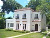


