National Register of Historic Places listings in Essex County, Virginia

Last updated

Location of Essex County in Virginia Map of Virginia highlighting Essex County.svg
Location of Essex County in Virginia

This is a list of the National Register of Historic Places listings in Essex County, Virginia.

Contents

This is intended to be a complete list of the properties and districts on the National Register of Historic Places in Essex County, Virginia, United States. The locations of National Register properties and districts for which the latitude and longitude coordinates are included below, may be seen in an online map. [1]

There are 17 properties and districts listed on the National Register in the county.


    This National Park Service list is complete through NPS recent listings posted March 4, 2022. [2]

Map all coordinates using: OpenStreetMap  
Download coordinates as: KML

Current listings

[3] Name on the Register [4] ImageDate listed [5] Location City or townDescription
1 Blandfield
Blandfield Blandfield, U.S. Route 17 & State Route 624, Caret vicinity (Essex County, Virginia).jpg
Blandfield
November 12, 1969
(#69000238)
North of the junction of U.S. Route 17 and Essex Church Rd.
38°00′02″N76°57′00″W / 38.0006°N 76.9500°W / 38.0006; -76.9500 (Blandfield)
Caret
2 Brooke's Bank
Brooke's Bank Brooke's Bank, U.S. Route 17 vicinity, Loretto vicinity (Essex County, Virginia).jpg
Brooke's Bank
September 28, 1971
(#71000976)
1 mile (1.6 km) east of Loretto and 1.4 miles (2.3 km) north of U.S. Route 17
38°05′24″N77°01′06″W / 38.0900°N 77.0182°W / 38.0900; -77.0182 (Brooke's Bank)
Loretto
3 Cherry Walk
Cherry Walk Cherry Walk from the road.jpg
Cherry Walk
February 10, 1983
(#83003280)
South of Dunbrooke on Dunbrooke Rd.
37°51′41″N76°56′59″W / 37.8613°N 76.9497°W / 37.8613; -76.9497 (Cherry Walk)
Dunbrooke
4 Edenetta
Edenetta Edenetta entrance.jpg
Edenetta
November 22, 2016
(#16000796)
6514 U.S. Route 17
38°03′47″N77°01′23″W / 38.0631°N 77.0231°W / 38.0631; -77.0231 (Edenetta)
Chance
5 Elmwood
Elmwood Elmwood, State Route 640 vicinity, Loretto vicinity (Essex County, Virginia).jpg
Elmwood
September 15, 1970
(#70000790)
West of the junction of U.S. Route 17 and Clarke's Store Rd.
38°05′07″N77°05′39″W / 38.0854°N 77.0942°W / 38.0854; -77.0942 (Elmwood)
Loretto
6 Glebe House of St. Anne's Parish
Glebe House of St. Anne's Parish St. Anne's Parish Glebe House, U.S. Route 17 near Route 632, Champlain vicinity (Essex County, Virginia).jpg
Glebe House of St. Anne's Parish
March 3, 1975
(#75002020)
2.5 miles (4.0 km) northeast of Champlain on the northern bank of Farmers Hall Creek
38°01′57″N76°57′13″W / 38.0326°N 76.9536°W / 38.0326; -76.9536 (Glebe House of St. Anne's Parish)
Champlain
7 Glencairn
Glencairn Glencairn in Essex County.jpg
Glencairn
May 14, 1979
(#79003036)
North of Chance off U.S. Route 17
38°03′54″N77°00′42″W / 38.0650°N 77.0118°W / 38.0650; -77.0118 (Glencairn)
Chance
8 Linden
Linden Linden from U.S. Route 17.jpg
Linden
October 15, 1992
(#92001397)
Southwestern side of U.S. Route 17, 0.5 miles (0.80 km) south of Champlain
38°00′18″N76°59′14″W / 38.0050°N 76.9872°W / 38.0050; -76.9872 (Linden)
Champlain
9 Millers Tavern Rural Historic District
Millers Tavern Rural Historic District St. Paul's Church near Millers Tavern.jpg
Millers Tavern Rural Historic District
June 5, 2017
(#100001040)
Roughly bounded by U.S. Route 360 and Howerton, Dunbrooke, Latanes Mill, and Midway Rds.
37°49′44″N76°58′04″W / 37.8289°N 76.9678°W / 37.8289; -76.9678 (Millers Tavern Rural Historic District)
Millers Tavern Extends into King and Queen County
10 Monte Verde
Monte Verde Mount Verde, State Route 660, Center Cross vicinity (Essex County, Virginia).jpg
Monte Verde
May 30, 2002
(#02000586)
405 Monte Verde Rd.
37°48′46″N76°45′45″W / 37.8128°N 76.7624°W / 37.8128; -76.7624 (Monte Verde)
Center Cross
11 Occupacia-Rappahannock Rural Historic District November 30, 2020
(#100005837)
Roughly bounded by the Essex County line, Supply, Clarkes Store, and Pilkington Rds., the Rappahannock R., Blandfield (028-5084-0510), and Tidewater Trail (US 17) through center.
38°06′16″N77°06′05″W / 38.1044°N 77.1014°W / 38.1044; -77.1014 (Occupacia-Rappahannock Rural Historic District)
Tappahannock vicinity
12 Port Micou
Port Micou Port Micou entrance.jpg
Port Micou
February 6, 1992
(#91002041)
Marlbank Rd. at the Rappahannock River
38°07′22″N77°03′20″W / 38.1229°N 77.0556°W / 38.1229; -77.0556 (Port Micou)
Loretto
13 St. Matthew's Church
St. Matthew's Church OCS Lg azalea.jpg
St. Matthew's Church
January 16, 2004
(#03001429)
Junction of U.S. Route 17 with Daingerfield Landing and St. Matthews Church Rds.
38°00′57″N76°59′32″W / 38.0158°N 76.9922°W / 38.0158; -76.9922 (St. Matthew's Church)
Champlain
14 Tappahannock Historic District
Tappahannock Historic District Tappahannock Historic District - Beale Memorial Baptist Church.jpg
Tappahannock Historic District
April 2, 1973
(#73002009)
Roughly bounded by Queen St., Church Lane, the Rappahannock River, and the grounds of St. Margaret's School
37°55′39″N76°51′31″W / 37.9275°N 76.8586°W / 37.9275; -76.8586 (Tappahannock Historic District)
Tappahannock
15 Vauter's Church
Vauter's Church Vauter's Episcopal Church, U.S. Route 17, Loretto vicinity (Essex County, Virginia).jpg
Vauter's Church
December 5, 1972
(#72001391)
1 mile (1.6 km) northwest of Loretto on U.S. Route 17
38°05′13″N77°04′07″W / 38.0869°N 77.0686°W / 38.0869; -77.0686 (Vauter's Church)
Loretto
16 Wheatland
Wheatland Wheatland entrance in Essex County.jpg
Wheatland
December 19, 1990
(#89001918)
Wheatland Rd. between U.S. Route 17 and the Rappahannock River
38°05′24″N77°02′06″W / 38.0900°N 77.0351°W / 38.0900; -77.0351 (Wheatland)
Loretto
17 Woodlawn
Woodlawn Woodlawn near Millers Tavern.jpg
Woodlawn
July 16, 1980
(#80004187)
Northeast of Miller's Tavern
37°51′08″N76°55′10″W / 37.8522°N 76.9194°W / 37.8522; -76.9194 (Woodlawn)
Miller's Tavern

See also

Related Research Articles

National Register of Historic Places listings in Alleghany County, Virginia

This is a list of the National Register of Historic Places listings in Alleghany County, Virginia.

National Register of Historic Places listings in Amelia County, Virginia

This is a list of the National Register of Historic Places listings in Amelia County, Virginia.

National Register of Historic Places listings in Bath County, Virginia

This is a list of the National Register of Historic Places listings in Bath County, Virginia.

National Register of Historic Places listings in Bedford County, Virginia

This is a list of the National Register of Historic Places listings in Bedford County, Virginia.

National Register of Historic Places listings in Washington County, Virginia

This is a list of the National Register of Historic Places listings in Washington County, Virginia.

National Register of Historic Places listings in Clarke County, Virginia

This is a list of the National Register of Historic Places listings in Clarke County, Virginia.

National Register of Historic Places listings in Goochland County, Virginia Wikimedia list article

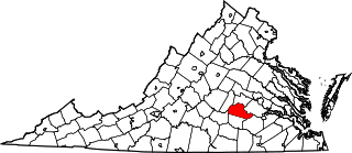
This is a list of the National Register of Historic Places listings in Goochland County, Virginia.

National Register of Historic Places listings in Greene County, Virginia

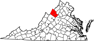
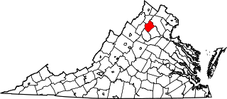
This is a list of the National Register of Historic Places listings in Greene County, Virginia.

National Register of Historic Places listings in Rockingham County, Virginia

This is a list of the National Register of Historic Places listings in Rockingham County, Virginia.

National Register of Historic Places listings in New Kent County, Virginia

This is a list of the National Register of Historic Places listings in New Kent County, Virginia.

National Register of Historic Places listings in Orange County, Virginia

This is a list of the National Register of Historic Places listings in Orange County, Virginia.

National Register of Historic Places listings in Rappahannock County, Virginia

This is a list of the National Register of Historic Places listings in Rappahannock County, Virginia.

National Register of Historic Places listings in Shenandoah County, Virginia

This is a list of the National Register of Historic Places listings in Shenandoah County, Virginia.

National Register of Historic Places listings in Nottoway County, Virginia

This is a list of the National Register of Historic Places listings in Nottoway County, Virginia.

National Register of Historic Places listings in Prince Edward County, Virginia

This is a list of the National Register of Historic Places listings in Prince Edward County, Virginia.

National Register of Historic Places listings in Lawrence, Massachusetts

The following properties are listed on the National Register of Historic Places in Lawrence, Massachusetts.

National Register of Historic Places listings in Salem, Massachusetts

This is a list of the National Register of Historic Places listings in Salem, Massachusetts.

National Register of Historic Places listings in Lynn, Massachusetts

This is a list of the National Register of Historic Places listings in Lynn, Massachusetts.

National Register of Historic Places listings in Giles County, Virginia

This is a list of the National Register of Historic Places listings in Giles County, Virginia.

National Register of Historic Places listings in Grayson County, Virginia Wikimedia list article

This is a list of the National Register of Historic Places listings in Grayson County, Virginia.

References

  1. The latitude and longitude information provided in this table was derived originally from the National Register Information System, which has been found to be fairly accurate for about 99% of listings. Some locations in this table may have been corrected to current GPS standards.
  2. National Park Service, United States Department of the Interior, "National Register of Historic Places: Weekly List Actions", retrieved March 4, 2022.
  3. Numbers represent an alphabetical ordering by significant words. Various colorings, defined here, differentiate National Historic Landmarks and historic districts from other NRHP buildings, structures, sites or objects.
  4. "National Register Information System". National Register of Historic Places . National Park Service. April 24, 2008.
  5. The eight-digit number below each date is the number assigned to each location in the National Register Information System database, which can be viewed by clicking the number.