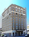
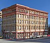
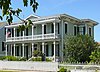
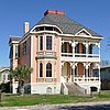
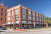
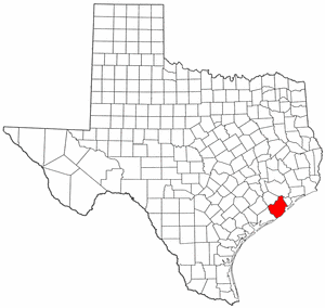
[3] Name on the Register [4] Image Date listed [5] Location City or town Description 1 American National Insurance Company (ANICO) American National Insurance Company (ANICO) May 20, 2021 (# 100006539 1 Moody Ave. (1902 Market St.) 29°18′24″N 94°47′24″W / 29.3068°N 94.7900°W / 29.3068; -94.7900 (American National Insurance Company (ANICO) ) Galveston AKA One Moody Plaza. 2 Ashton Villa Ashton Villa October 28, 1969 (# 69000204 2328 Broadway 29°17′59″N 94°47′33″W / 29.2997°N 94.7925°W / 29.2997; -94.7925 (Ashton Villa ) Galveston Recorded Texas Historic Landmark 3 Bayou Brae Historic District Upload image May 24, 2021 (# 100006547 All properties on Bayou Dr., Brae Ln., Coryell St., Oboe Trail, Woodwind Way, and Viola Dr. 29°31′36″N 95°04′35″W / 29.5267°N 95.0764°W / 29.5267; -95.0764 (Bayou Brae Historic District ) League City 4 Henry Beissner House Henry Beissner House April 3, 1978 (# 78002929 2818 Ball Ave. 29°18′01″N 94°47′56″W / 29.3003°N 94.7989°W / 29.3003; -94.7989 (Henry Beissner House ) Galveston 5 Bishop's Palace Bishop's Palace August 25, 1970 (# 70000746 1402 Ave. J (Broadway) 29°18′17″N 94°46′55″W / 29.3047°N 94.7819°W / 29.3047; -94.7819 (Bishop's Palace ) Galveston Recorded Texas Historic Landmark, part of East End Historic District 6 Broadway Cemetery Historic District Broadway Cemetery Historic District June 13, 2014 (# 14000340 6 blocks between Broadway Ave., Ave. L, 43rd & 40th Sts. 29°17′37″N 94°48′46″W / 29.2935°N 94.8129°W / 29.2935; -94.8129 (Broadway Cemetery Historic District ) Galveston 7 Building at 1921–1921 1/2 Avenue D Building at 1921–1921 1/2 Avenue D August 14, 1984 (# 84001671 1921–1921 1/2 Ave. D 29°18′21″N 94°47′23″W / 29.3058°N 94.7897°W / 29.3058; -94.7897 (Building at 1921–1921 1/2 Avenue D ) Galveston Historic Resources of the Galveston Central Business District MRA 8 Building at 1925–1927 Market Street Building at 1925–1927 Market Street August 14, 1984 (# 84001668 1925–1927 Market St. 29°18′25″N 94°47′29″W / 29.3069°N 94.7914°W / 29.3069; -94.7914 (Building at 1925–1927 Market Street ) Galveston Historic Resources of the Galveston Central Business District MRA 9 Cedar Lawn Historic District Cedar Lawn Historic District December 20, 2002 (# 02001570 Bounded by 45th. St., 48th St., Ave. L, and Ave. N, 29°17′23″N 94°49′04″W / 29.2897°N 94.8178°W / 29.2897; -94.8178 (Cedar Lawn Historic District ) Galveston 10 City Hall City Hall August 14, 1984 (# 84001676 823 25th St. 29°18′01″N 94°47′43″W / 29.3003°N 94.7953°W / 29.3003; -94.7953 (City Hall ) Galveston Historic Resources of the Galveston Central Business District MRA 11 City National Bank City National Bank August 14, 1984 (# 84001680 2219 Market St 29°18′20″N 94°47′36″W / 29.3055°N 94.7933°W / 29.3055; -94.7933 (City National Bank ) Galveston Historic Resources of the Galveston Central Business District MRA 12 Congregation Beth Jacob Congregation Beth Jacob January 4, 2024 (# 100009737 2401 Avenue K 29°17′55″N 94°47′34″W / 29.2986°N 94.7929°W / 29.2986; -94.7929 (Congregation Beth Jacob ) Galveston 13 Frank B. Davison House Frank B. Davison House June 29, 1976 (# 76002033 109 3rd Ave. 29°23′13″N 94°53′42″W / 29.3869°N 94.895°W / 29.3869; -94.895 (Frank B. Davison House ) Texas City State Antiquities Landmark , Recorded Texas Historic Landmark 14 Denver Court Historic District Denver Court Historic District January 14, 2002 (# 01001471 Roughly bounded by Aves. S1/2 and U1/2, 43rd and 52nd Sts. 29°16′39″N 94°48′54″W / 29.2775°N 94.815°W / 29.2775; -94.815 (Denver Court Historic District ) Galveston 15 East End Historic District East End Historic District May 30, 1975 (# 75001979 Irregular pattern including both sides of Broadway and Market Sts. 29°18′16″N 94°46′58″W / 29.3044°N 94.7828°W / 29.3044; -94.7828 (East End Historic District ) Galveston Includes Recorded Texas Historic Landmarks 16 Eiband's Eiband's August 14, 1984 (# 84001683 2001 Central Plaza 29°18′16″N 94°47′32″W / 29.3044°N 94.7922°W / 29.3044; -94.7922 (Eiband's ) Galveston Historic Resources of the Galveston Central Business District MRA 17 ELISSA ELISSA March 21, 1978 (# 78002930 Pier 21, 21st Street and Harborside Drive 29°18′34″N 94°47′37″W / 29.30946667°N 94.7936°W / 29.30946667; -94.7936 (ELISSA Galveston 18 Falstaff Brewery Falstaff Brewery August 29, 2018 (# 100002841 3302 Church St. (Ave. F) 29°18′03″N 94°48′22″W / 29.3007°N 94.8061°W / 29.3007; -94.8061 (Falstaff Brewery ) Galveston This structure is currently abandoned 19 First Evangelical Lutheran Church First Evangelical Lutheran Church August 14, 1984 (# 84001688 2401 Ave. G 29°18′09″N 94°47′39″W / 29.3025°N 94.7942°W / 29.3025; -94.7942 (First Evangelical Lutheran Church ) Galveston Recorded Texas Historic Landmark; Historic Resources of the Galveston Central Business District MRA 20 First Presbyterian Church First Presbyterian Church January 29, 1979 (# 79002942 1903 Church St. 29°18′15″N 94°47′19″W / 29.3042°N 94.7886°W / 29.3042; -94.7886 (First Presbyterian Church ) Galveston Recorded Texas Historic Landmark 21 Fort Travis Fort Travis March 30, 2005 (# 05000247 TX 87 at Loop 108 29°21′53″N 94°45′29″W / 29.3647°N 94.7581°W / 29.3647; -94.7581 (Fort Travis ) Port Bolivar State Antiquities Landmark 22 Galveston Causeway Galveston Causeway December 12, 1976 (# 76002028 Spans Galveston Bay from Virginia Point to Galveston Island 29°17′51″N 94°53′12″W / 29.2975°N 94.8867°W / 29.2975; -94.8867 (Galveston Causeway ) Galveston State Antiquities Landmark 23 Galveston, Houston & Henderson (GH&H) Freight Depot Galveston, Houston & Henderson (GH&H) Freight Depot January 10, 2020 (# 100004866 325 33rd St. 29°18′09″N 94°48′20″W / 29.3025°N 94.8055°W / 29.3025; -94.8055 (Galveston, Houston & Henderson (GH&H) Freight Depot ) Galveston 24 Galveston Orphans Home Galveston Orphans Home March 21, 1979 (# 79002943 1315 21st St. 29°17′50″N 94°47′19″W / 29.297222°N 94.788611°W / 29.297222; -94.788611 (Galveston Orphans Home ) Galveston Recorded Texas Historic Landmark 25 Galveston Seawall Galveston Seawall August 18, 1977 (# 77001443 Seawall Blvd. 29°18′09″N 94°46′27″W / 29.3025°N 94.774167°W / 29.3025; -94.774167 (Galveston Seawall ) Galveston State Antiquities Landmark 26 Galveston US Post Office, Custom House and Courthouse Galveston US Post Office, Custom House and Courthouse April 25, 2001 (# 01000438 601 25th St. (Rosenberg St.) [6] 29°18′08″N 94°47′45″W / 29.302222°N 94.795833°W / 29.302222; -94.795833 (Galveston US Post Office, Custom House and Courthouse ) Galveston 27 Galvez Hotel Galvez Hotel April 4, 1979 (# 79002944 2024 Seawall Blvd. 29°17′32″N 94°47′08″W / 29.292222°N 94.785556°W / 29.292222; -94.785556 (Galvez Hotel ) Galveston Recorded Texas Historic Landmark 28 Garten Verein Pavilion Garten Verein Pavilion July 20, 1977 (# 77001444 27th St. and Avenue O (Kempner Park) 29°17′34″N 94°47′41″W / 29.292778°N 94.794722°W / 29.292778; -94.794722 (Garten Verein Pavilion ) Galveston State Antiquities Landmark, Recorded Texas Historic Landmark 29 Grace Episcopal Church Grace Episcopal Church April 3, 1975 (# 75001980 1115 36th St. 29°17′39″N 94°48′23″W / 29.294167°N 94.806389°W / 29.294167; -94.806389 (Grace Episcopal Church ) Galveston Recorded Texas Historic Landmark 30 Grand Opera House Grand Opera House January 2, 1974 (# 74002071 2012–2020 Ave. E 29°17′47″N 94°47′26″W / 29.296389°N 94.790556°W / 29.296389; -94.790556 (Grand Opera House ) Galveston Recorded Texas Historic Landmark 31 John Hagemann House John Hagemann House June 1, 1982 (# 82004505 3301 Ave. L 29°17′40″N 94°48′47″W / 29.294444°N 94.813056°W / 29.294444; -94.813056 (John Hagemann House ) Galveston Recorded Texas Historic Landmark 32 House at 2017–2023 Avenue I House at 2017–2023 Avenue I August 14, 1984 (# 84001698 2017–2023 Ave. I 29°18′05″N 94°47′07″W / 29.301389°N 94.785278°W / 29.301389; -94.785278 (House at 2017–2023 Avenue I ) Galveston Historic Resources of the Galveston Central Business District MRA 33 House at 2528 Postoffice St. House at 2528 Postoffice St. August 14, 1984 (# 84001700 2528 Postoffice St. 29°18′13″N 94°47′49″W / 29.303611°N 94.796944°W / 29.303611; -94.796944 (House at 2528 Postoffice St. ) Galveston Historic Resources of the Galveston Central Business District MRA 34 Sealy Hutchings House Sealy Hutchings House July 29, 1994 (# 94000796 2805 Ave. O 29°17′31″N 94°47′44″W / 29.291944°N 94.795556°W / 29.291944; -94.795556 (Sealy Hutchings House ) Galveston 35 I.O.O.F. Lodge I.O.O.F. Lodge August 14, 1984 (# 84001703 505 20th St. 29°18′18″N 94°47′24″W / 29.305°N 94.79°W / 29.305; -94.79 (I.O.O.F. Lodge ) Galveston Historic Resources of the Galveston Central Business District MRA 36 Illies Building-Justine Apartments Illies Building-Justine Apartments August 22, 1995 (# 95001028 503 21st St. 29°17′49″N 94°46′56″W / 29.296944°N 94.782222°W / 29.296944; -94.782222 (Illies Building-Justine Apartments ) Galveston Historic Resources of the Galveston Central Business District MRA 37 Daniel Webster Kempner House Daniel Webster Kempner House March 30, 1979 (# 79002945 2504 Ave. O 29°17′35″N 94°47′34″W / 29.293056°N 94.792778°W / 29.293056; -94.792778 (Daniel Webster Kempner House ) Galveston Part of Silk Stocking Residential Historic District 38 Jean Lafitte Hotel Jean Lafitte Hotel August 14, 1984 (# 84001705 2105 Ave. F 29°18′14″N 94°47′27″W / 29.303889°N 94.790833°W / 29.303889; -94.790833 (Jean Lafitte Hotel ) Galveston Historic Resources of the Galveston Central Business District MRA 39 Lasker Home for Homeless Children Lasker Home for Homeless Children April 14, 1983 (# 83003140 1019 16th St. 29°18′02″N 94°47′01″W / 29.300556°N 94.783611°W / 29.300556; -94.783611 (Lasker Home for Homeless Children ) Galveston Recorded Texas Historic Landmark; part of Lost Bayou Historic District 40 E.S. Levy Building E.S. Levy Building November 13, 2003 (# 03001163 2221–2225 Market St. 29°18′17″N 94°47′36″W / 29.304722°N 94.793333°W / 29.304722; -94.793333 (E.S. Levy Building ) Galveston Historic Resources of the Galveston Central Business District MRA 41 Lost Bayou Historic District Lost Bayou Historic District June 19, 2017 (# 100001224 Roughly bounded by Broadway, Ave. N, 14th & 21st Sts. 29°17′58″N 94°47′06″W / 29.299416°N 94.784990°W / 29.299416; -94.784990 (Lost Bayou Historic District ) Galveston Includes Recorded Texas Historic Landmarks 42 Marschner Building Marschner Building August 14, 1984 (# 84001706 1914–1916 Mechanic St. 29°18′26″N 94°47′23″W / 29.307222°N 94.789722°W / 29.307222; -94.789722 (Marschner Building ) Galveston Recorded Texas Historic Landmark; Historic Resources of the Galveston Central Business District MRA 43 McKinney-McDonald House McKinney-McDonald House May 4, 1976 (# 76002030 926 Winnie St. 29°18′24″N 94°46′39″W / 29.306667°N 94.7775°W / 29.306667; -94.7775 (McKinney-McDonald House ) Galveston 44 Melrose Apartment Building Melrose Apartment Building October 14, 1998 (# 98001246 2002 Post Office St. 29°18′19″N 94°47′26″W / 29.305278°N 94.790556°W / 29.305278; -94.790556 (Melrose Apartment Building ) Galveston Historic Resources of the Galveston Central Business District MRA 45 Michel B. Menard House Michel B. Menard House December 12, 1976 (# 76002031 1605 33rd St. 29°17′27″N 94°48′06″W / 29.290833°N 94.801667°W / 29.290833; -94.801667 (Michel B. Menard House ) Galveston 46 Merimax Building Merimax Building January 24, 1985 (# 85000121 521 22nd St. 29°18′15″N 94°47′32″W / 29.304124°N 94.792335°W / 29.304124; -94.792335 (Merimax Building ) Galveston Historic Resources of the Galveston Central Business District MRA 47 Model Laundry Model Laundry August 14, 1984 (# 84001707 513–523 25th St. 29°18′10″N 94°47′45″W / 29.302778°N 94.795833°W / 29.302778; -94.795833 (Model Laundry ) Galveston Historic Resources of the Galveston Central Business District MRA 48 Col. Hugh B. and Helen Moore House Col. Hugh B. and Helen Moore House October 28, 1994 (# 94001241 8 Ninth Ave., N. 29°23′38″N 94°54′10″W / 29.393889°N 94.902778°W / 29.393889; -94.902778 (Col. Hugh B. and Helen Moore House ) Texas City Recorded Texas Historic Landmark 49 Mosquito Fleet Berth, Pier 19 Mosquito Fleet Berth, Pier 19 April 21, 1975 (# 75001981 N end of 20th St., Pier 19 29°18′39″N 94°47′25″W / 29.310833°N 94.790278°W / 29.310833; -94.790278 (Mosquito Fleet Berth, Pier 19 ) Galveston State Antiquities Landmark 50 Old Galveston Customhouse Old Galveston Customhouse August 25, 1970 (# 70000747 Southeast corner 20th and Post Office (Ave. E) Sts. 29°18′18″N 94°47′23″W / 29.305°N 94.789722°W / 29.305; -94.789722 (Old Galveston Customhouse ) Galveston 51 Parkland Apartments Upload image January 7, 2022 (# 100007354 3916 Winnie St. (Ave. G) 29°17′52″N 94°48′43″W / 29.2979°N 94.8119°W / 29.2979; -94.8119 (Parkland Apartments ) Galveston 52 Pix Building Pix Building August 14, 1984 (# 84001713 2128 Postoffice St. 29°18′18″N 94°47′32″W / 29.305°N 94.792222°W / 29.305; -94.792222 (Pix Building ) Galveston Historic Resources of the Galveston Central Business District MRA 53 Point Bolivar Lighthouse Point Bolivar Lighthouse August 18, 1977 (# 77001445 TX 87 29°22′00″N 94°46′00″W / 29.366667°N 94.766667°W / 29.366667; -94.766667 (Point Bolivar Lighthouse ) Port Bolivar 54 Powhatan House Powhatan House October 6, 1975 (# 75001982 3427 Ave. O 29°17′24″N 94°48′11″W / 29.29°N 94.803056°W / 29.29; -94.803056 (Powhatan House ) Galveston Recorded Texas Historic Landmark 55 Quigg-Baulard House Quigg-Baulard House September 17, 2015 (# 15000618 2628 Broadway 29°17′57″N 94°47′48″W / 29.299228°N 94.796545°W / 29.299228; -94.796545 (Quigg-Baulard House ) Galveston Recorded Texas Historic Landmark 56 Reedy Chapel-AME Church Reedy Chapel-AME Church September 14, 1984 (# 84001717 2013 Broadway 29°18′00″N 94°47′19″W / 29.3°N 94.788611°W / 29.3; -94.788611 (Reedy Chapel-AME Church ) Galveston Recorded Texas Historic Landmark 57 Robinson Building Robinson Building August 14, 1984 (# 84001720 2009–2011 Postoffice St. 29°18′17″N 94°47′26″W / 29.304722°N 94.790556°W / 29.304722; -94.790556 (Robinson Building ) Galveston Historic Resources of the Galveston Central Business District MRA 58 Rosenberg Library Rosenberg Library August 14, 1984 (# 84001722 2310 Sealy St. 29°18′03″N 94°47′34″W / 29.300833°N 94.792778°W / 29.300833; -94.792778 (Rosenberg Library ) Galveston Historic Resources of the Galveston Central Business District MRA 59 Scottish Rite Cathedral Scottish Rite Cathedral August 14, 1984 (# 84001724 2128 Church St. 29°18′14″N 94°47′30″W / 29.303889°N 94.791667°W / 29.303889; -94.791667 (Scottish Rite Cathedral ) Galveston Historic Resources of the Galveston Central Business District MRA 60 George Sealy House George Sealy House October 28, 1969 (# 69000205 2424 Broadway 29°17′59″N 94°47′37″W / 29.299722°N 94.793611°W / 29.299722; -94.793611 (George Sealy House ) Galveston Recorded Texas Historic Landmark 61 The Settlement Historic District The Settlement Historic District May 17, 2010 (# 10000268 Centered on the intersection of N Bell Dr and the 100 block of S Bell Dr with cross-streets Carver Ave and Eunice St 29°22′58″N 94°58′38″W / 29.382778°N 94.977222°W / 29.382778; -94.977222 (The Settlement Historic District ) Texas City 62 M. W. Shaw Building M. W. Shaw Building August 14, 1984 (# 84001728 2427 Ave. D 29°18′16″N 94°47′45″W / 29.304444°N 94.795833°W / 29.304444; -94.795833 (M. W. Shaw Building ) Galveston Historic Resources of the Galveston Central Business District MRA 63 Silk Stocking Residential Historic District Silk Stocking Residential Historic District May 10, 1996 (# 96000539 Roughly bounded by Ave. K, 23rd St., Ave. P, and 26th St. 29°17′42″N 94°47′30″W / 29.295°N 94.791667°W / 29.295; -94.791667 (Silk Stocking Residential Historic District ) Galveston Includes Recorded Texas Historic Landmarks 64 Ashbel Smith Building Ashbel Smith Building October 28, 1969 (# 69000203 914–916 Ave. B 29°18′48″N 94°46′44″W / 29.313333°N 94.778889°W / 29.313333; -94.778889 (Ashbel Smith Building ) Galveston State Antiquities Landmark, Recorded Texas Historic Landmark 65 SS SELMA (steamship) SS SELMA (steamship) January 5, 1994 (# 93001449 Within the channel between Galveston and Port Bolivar 29°20′39″N 94°47′11″W / 29.344276°N 94.786407°W / 29.344276; -94.786407 (SS SELMA (steamship) ) Galveston 66 St. Joseph's Church St. Joseph's Church December 12, 1976 (# 76002032 2202 Ave. K 29°17′57″N 94°47′26″W / 29.299167°N 94.790556°W / 29.299167; -94.790556 (St. Joseph's Church ) Galveston Recorded Texas Historic Landmark 67 St. Mary's Cathedral St. Mary's Cathedral June 4, 1973 (# 73001964 2011 Church Ave. 29°18′14″N 94°47′24″W / 29.303889°N 94.79°W / 29.303889; -94.79 (St. Mary's Cathedral ) Galveston Recorded Texas Historic Landmark 68 Star Drug Store Star Drug Store August 14, 1984 (# 84001731 510 23rd St. 29°18′14″N 94°47′35″W / 29.303889°N 94.793056°W / 29.303889; -94.793056 (Star Drug Store ) Galveston Historic Resources of the Galveston Central Business District MRA 69 Steffens-Drewa House Complex Steffens-Drewa House Complex December 1, 1988 (# 88002671 2701, 2705, and 2709 Ave. O 29°17′32″N 94°47′40″W / 29.292222°N 94.794444°W / 29.292222; -94.794444 (Steffens-Drewa House Complex ) Galveston 70 The Strand Historic District The Strand Historic District January 26, 1970 (# 70000748 Roughly bounded by Ave. A, 20th St., alley between Aves. C and D, and railroad depot 29°18′23″N 94°47′37″W / 29.306389°N 94.793611°W / 29.306389; -94.793611 (The Strand Historic District ) Galveston Includes Recorded Texas Historic Landmarks 71 Stringfellow Orchards Stringfellow Orchards February 27, 2013 (# 13000043 7902 TX 6 29°21′00″N 95°01′01″W / 29.35011°N 95.01708°W / 29.35011; -95.01708 (Stringfellow Orchards ) Hitchcock 72 Sweeney-Royston House Sweeney-Royston House September 1, 1978 (# 78002931 2402 Ave. L 29°17′52″N 94°47′32″W / 29.297778°N 94.792222°W / 29.297778; -94.792222 (Sweeney-Royston House ) Galveston Recorded Texas Historic Landmark; part of Silk Stocking Residential Historic District 73 Texas Building Texas Building August 14, 1984 (# 84001734 2200 Central Plaza 29°18′18″N 94°47′33″W / 29.305032°N 94.792604°W / 29.305032; -94.792604 (Texas Building ) Galveston Historic Resources of the Galveston Central Business District MRA 74 Texas Heroes Monument Texas Heroes Monument August 14, 1984 (# 84001737 25th and Broadway 29°17′57″N 94°47′39″W / 29.299167°N 94.794167°W / 29.299167; -94.794167 (Texas Heroes Monument ) Galveston Historic Resources of the Galveston Central Business District MRA 75 Trinity Protestant Episcopal Church Trinity Protestant Episcopal Church September 4, 1979 (# 79002946 22nd St. and Ave. G 29°18′08″N 94°47′31″W / 29.302222°N 94.791944°W / 29.302222; -94.791944 (Trinity Protestant Episcopal Church ) Galveston Includes Recorded Texas Historic Landmarks 76 Trueheart-Adriance Building Trueheart-Adriance Building July 14, 1971 (# 71000933 212 22nd St. 29°18′24″N 94°47′33″W / 29.306667°N 94.7925°W / 29.306667; -94.7925 (Trueheart-Adriance Building ) Galveston Recorded Texas Historic Landmark; part of The Strand Historic District 77 U.S. National Bank U.S. National Bank August 14, 1984 (# 84001739 2201 Ave. D 29°18′19″N 94°47′34″W / 29.305278°N 94.792778°W / 29.305278; -94.792778 (U.S. National Bank ) Galveston Historic Resources of the Galveston Central Business District MRA 78 USS CAVALLA (submarine) USS CAVALLA (submarine) May 27, 2008 (# 08000477 East End of Seawolf Park 29°20′09″N 94°46′46″W / 29.335833°N 94.779444°W / 29.335833; -94.779444 (USS CAVALLA (submarine) ) Galveston 79 USS HATTERAS (41GV68) USS HATTERAS (41GV68) January 28, 1977 (# 77001567 Address restricted [7] Galveston Sunk 20 miles (32 km) off the Galveston coast during the Civil War. 80 USS STEWART USS STEWART July 12, 2007 (# 07000689 East End of Seawolf Park 29°20′09″N 94°46′46″W / 29.335833°N 94.779444°W / 29.335833; -94.779444 (USS STEWART ) Galveston 81 Samuel May Williams House Samuel May Williams House July 14, 1971 (# 71000934 3601 Ave. P 29°17′16″N 94°48′15″W / 29.287778°N 94.804167°W / 29.287778; -94.804167 (Samuel May Williams House ) Galveston Recorded Texas Historic Landmark 82 Willis-Moody Mansion Willis-Moody Mansion May 13, 1994 (# 94000410 2618 Broadway 29°17′57″N 94°47′46″W / 29.299167°N 94.796111°W / 29.299167; -94.796111 (Willis-Moody Mansion ) Galveston Recorded Texas Historic Landmark