National Register of Historic Places listings in Gloucester County, Virginia

Last updated

Location of Gloucester County in Virginia Map of Virginia highlighting Gloucester County.svg
Location of Gloucester County in Virginia

This is a list of the National Register of Historic Places listings in Gloucester County, Virginia.

Contents

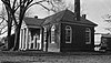
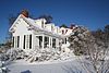
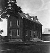
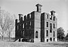
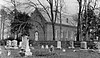
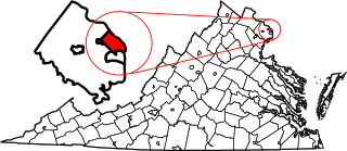
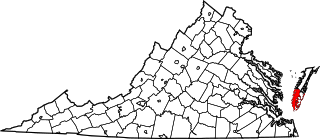
This is intended to be a complete list of the properties and districts on the National Register of Historic Places in Gloucester County, Virginia, United States. The locations of National Register properties and districts for which the latitude and longitude coordinates are included below, may be seen in an online map. [1]

There are 34 properties and districts listed on the National Register in the county, including 1 National Historic Landmark.


    This National Park Service list is complete through NPS recent listings posted March 18, 2022. [2]

Map all coordinates using: OpenStreetMap  
Download coordinates as: KML

Current listings

[3] Name on the Register [4] ImageDate listed [5] Location City or townDescription
1 Abingdon Church
Abingdon Church Abingdon Church - entrance.JPG
Abingdon Church
September 15, 1970
(#70000796)
U.S. Route 17 south of its junction with Feather Bed Ln.
37°20′01″N76°30′48″W / 37.333611°N 76.513333°W / 37.333611; -76.513333 (Abingdon Church)
White Marsh
2 Abingdon Glebe House
Abingdon Glebe House Abingdon Glebe House, U.S. Route 17 vicinity, Gloucester vicinity Gloucester County, Virginia).jpg
Abingdon Glebe House
September 15, 1970
(#70000794)
South of the junction of U.S. Route 17 and Burleigh Rd.
37°22′38″N76°32′26″W / 37.377222°N 76.540556°W / 37.377222; -76.540556 (Abingdon Glebe House)
Gloucester
3 Airville
Airville AIRVILLE, GLOUCESTER, GLOUCESTER COUNTY, VA.jpg
Airville
December 6, 1990
(#90001824)
T.C. Walker Rd., south of its junction with Zanoni Rd.
37°23′14″N76°30′13″W / 37.387222°N 76.503611°W / 37.387222; -76.503611 (Airville)
Gloucester
4 Burgh Westra
Burgh Westra BURGH WESTRA WATER SIDE.jpg
Burgh Westra
October 8, 1976
(#76002107)
East of Gloucester off State Route 3
37°25′11″N76°27′12″W / 37.419722°N 76.453472°W / 37.419722; -76.453472 (Burgh Westra)
Gloucester
5 Cappahosic House
Cappahosic House CAPPAHOSIC HOUSE.jpg
Cappahosic House
April 11, 2003
(#03000211)
3198 Cappahosic Rd.
37°22′51″N76°37′59″W / 37.380833°N 76.633056°W / 37.380833; -76.633056 (Cappahosic House)
Gloucester
6 Fairfield Site
Fairfield Site Fairfield Site with cornfield.jpg
Fairfield Site
July 16, 1973
(#73002019)
North of the York River [6]
37°20′28″N76°33′14″W / 37.341111°N 76.553889°W / 37.341111; -76.553889 (Fairfield Site)
White Marsh Faced Carter's Creek until its destruction by fire circa 1900 [7]
7 Gloucester County Courthouse Square Historic District
Gloucester County Courthouse Square Historic District Gloucester County Courthouse, U.S. Route 17, Gloucester (Gloucester County, Virginia).jpg
Gloucester County Courthouse Square Historic District
October 3, 1973
(#73002016)
Main St. and Gloucester County Courthouse Sq.
37°24′53″N76°31′47″W / 37.414722°N 76.529722°W / 37.414722; -76.529722 (Gloucester County Courthouse Square Historic District)
Gloucester
8 Gloucester Downtown Historic District
Gloucester Downtown Historic District Gloucester va courthouse region 2.JPG
Gloucester Downtown Historic District
December 27, 2010
(#10001063)
Seven blocks of Main St. from the courthouse circle to Ware House Rd.
37°24′48″N76°31′26″W / 37.413333°N 76.523889°W / 37.413333; -76.523889 (Gloucester Downtown Historic District)
Gloucester
9 Gloucester Point Archaeological District
Gloucester Point Archaeological District Gloucester Point fort.jpg
Gloucester Point Archaeological District
June 10, 1985
(#85001251)
Off U.S. Route 13 on Gloucester Point [8]
37°15′00″N76°30′00″W / 37.250000°N 76.500000°W / 37.250000; -76.500000 (Gloucester Point Archaeological District)
Gloucester Point
10 Gloucester Women's Club
Gloucester Women's Club Gloucester Women's Club, U.S. Route 17 & State Route 14, Gloucester (Gloucester County, Virginia).jpg
Gloucester Women's Club
January 24, 1974
(#74002117)
On U.S. Route 17
37°24′45″N76°31′10″W / 37.412500°N 76.519444°W / 37.412500; -76.519444 (Gloucester Women's Club)
Gloucester
11 Hockley
Hockley Hockley fields.jpg
Hockley
July 9, 2010
(#10000446)
6640 Ware Neck Rd.
37°23′51″N76°27′55″W / 37.397500°N 76.465278°W / 37.397500; -76.465278 (Hockley)
Gloucester
12 Holly Knoll
Holly Knoll HOLLY KNOLL.jpg
Holly Knoll
December 21, 1981
(#81000640)
Off Allmondsville Rd.
37°23′16″N76°38′38″W / 37.387778°N 76.643889°W / 37.387778; -76.643889 (Holly Knoll)
Capahosic Home of Robert R. Moton
13 Kempsville
Kempsville Kempsville from 33.jpg
Kempsville
December 21, 1978
(#78003018)
East of Shacklefords on State Route 33
37°33′44″N76°38′22″W / 37.562222°N 76.639444°W / 37.562222; -76.639444 (Kempsville)
Shacklefords
14 Kenwood
Kenwood Kenwood1.jpg
Kenwood
May 18, 2015
(#15000251)
7437 Kenwood Ln.
37°25′02″N76°33′15″W / 37.417222°N 76.554167°W / 37.417222; -76.554167 (Kenwood)
Gloucester
15 Lands End
Lands End Land's End, Severn River, Naxera vicinity (Gloucester County, Virginia).jpg
Lands End
November 6, 1974
(#74002118)
Southeast of Naxera on The Corderoy
37°19′35″N76°25′31″W / 37.326389°N 76.425278°W / 37.326389; -76.425278 (Lands End)
Naxera
16 Little England
Little England Little England, State Route 672 vicinity, Bena vicinity (Gloucester County, Virginia).jpg
Little England
December 18, 1970
(#70000795)
East of Gloucester Point on Little England Rd.
37°15′14″N76°28′45″W / 37.253889°N 76.479167°W / 37.253889; -76.479167 (Little England)
Gloucester Point
17 Lowland Cottage
Lowland Cottage Lowland Cottage drive.jpg
Lowland Cottage
September 22, 1971
(#71001104)
Southwest of Ware Neck, 0.5 miles south of Ware Neck Rd.
37°23′49″N76°28′02″W / 37.396806°N 76.467222°W / 37.396806; -76.467222 (Lowland Cottage)
Ware Neck
18 Point Lookout Archaeological Site
Point Lookout Archaeological Site Point Lookout Archaeological Site.jpg
Point Lookout Archaeological Site
May 19, 2014
(#14000234)
Mobjack Rd. [9]
37°21′03″N76°26′23″W / 37.350833°N 76.439722°W / 37.350833; -76.439722 (Point Lookout Archaeological Site)
White Marsh
19 Walter Reed Birthplace
Walter Reed Birthplace Dr. Walter Reed House, State Routes 614 & 616, Gloucester vicinity (Gloucester County, Virginia).jpg
Walter Reed Birthplace
September 20, 1973
(#73002017)
Southwest of Gloucester at the junction of Belroi and Hickory Fork Rds.; also 4021 Hickory Fork Rd.
37°23′18″N76°35′17″W / 37.388472°N 76.588194°W / 37.388472; -76.588194 (Walter Reed Birthplace)
Belroi Hickory Fork Rd. address represents a boundary increase of December 15, 2015
20 Roaring Spring
Roaring Spring Roaring Spring entrance.jpg
Roaring Spring
September 22, 1972
(#72001395)
0.3 miles (0.48 km) east of Roaring Spring Rd.
37°26′00″N76°31′27″W / 37.433472°N 76.524028°W / 37.433472; -76.524028 (Roaring Spring)
Gloucester
21 Rosewell
Rosewell Rosewell, Carter Creek, White Marsh vicinity (Gloucester County, Virginia).jpg
Rosewell
October 1, 1969
(#69000244)
5113 Old Rosewell Ln.
37°19′41″N76°34′34″W / 37.327917°N 76.576111°W / 37.327917; -76.576111 (Rosewell)
Gloucester
22 Shelly Archeological District
Shelly Archeological District Shelly Archeological District.jpg
Shelly Archeological District
July 12, 1990
(#89001932)
York River [10]
37°19′20″N76°34′00″W / 37.322222°N 76.566667°W / 37.322222; -76.566667 (Shelly Archeological District)
Hayes
23 Site 44GL103-Quest End
Site 44GL103-Quest End Quest End from the road.jpg
Site 44GL103-Quest End
September 10, 1979
(#08000387)
5488 and 5476 Roanes Wharf Rd.
37°21′46″N76°28′11″W / 37.362778°N 76.469722°W / 37.362778; -76.469722 (Site 44GL103-Quest End)
Selden
24 Timberneck
Timberneck TIMBERNECK, WICOMICO, GLOUCESTER COUNTY, VA.jpg
Timberneck
September 10, 1979
(#79003041)
East of Wicomico off Borden Rd.
37°17′51″N76°32′09″W / 37.297500°N 76.535833°W / 37.297500; -76.535833 (Timberneck)
Wicomico
25 Toddsbury
Toddsbury Toddsbury, Vicinity of State Routes 622 & 3-14 Intersection, Nuttall vicinity (Gloucester County, Virginia).jpg
Toddsbury
November 12, 1969
(#69000245)
East of the junction of State Route 14 and Toddsbury Ln.
37°26′05″N76°27′05″W / 37.434722°N 76.451389°W / 37.434722; -76.451389 (Toddsbury)
Gloucester
26 Troop 111 Boy Scout Cabin November 18, 2021
(#100007187)
6361 Main St.
37°25′00″N76°32′08″W / 37.4166°N 76.5355°W / 37.4166; -76.5355 (Troop 111 Boy Scout Cabin)
Gloucester
27 T.C. Walker House
T.C. Walker House T.C. Walker House.jpg
T.C. Walker House
December 4, 2009
(#09001050)
1 Main St.
37°24′47″N76°31′19″W / 37.413111°N 76.521944°W / 37.413111; -76.521944 (T.C. Walker House)
Gloucester
28 Ware Neck Store and Post Office
Ware Neck Store and Post Office Ware Neck Store and Post Office.jpg
Ware Neck Store and Post Office
June 3, 2009
(#09000393)
6495 Dunham Massie Rd.
37°24′10″N76°27′32″W / 37.402778°N 76.458750°W / 37.402778; -76.458750 (Ware Neck Store and Post Office)
Ware Neck
29 Ware Parish Church
Ware Parish Church Ware Church, State Route 3, Gloucester vicinity (Gloucester County, Virginia).jpg
Ware Parish Church
March 20, 1973
(#73002018)
Northeast of Gloucester on State Route 14
37°25′21″N76°30′27″W / 37.422500°N 76.507500°W / 37.422500; -76.507500 (Ware Parish Church)
Gloucester
30 Warner Hall
Warner Hall Warner Hall.jpg
Warner Hall
November 25, 1980
(#80004191)
Warner Hall Rd.
37°20′26″N76°28′33″W / 37.340556°N 76.475833°W / 37.340556; -76.475833 (Warner Hall)
Gloucester
31 Werowocomoco Archeological Site
Werowocomoco Archeological Site Werowocomoco gate.jpg
Werowocomoco Archeological Site
March 15, 2006
(#06000138)
3051 Ginny Hill Rd.
37°24′38″N76°39′20″W / 37.410556°N 76.655556°W / 37.410556; -76.655556 (Werowocomoco Archeological Site)
Gloucester
32 White Hall
White Hall White Hall avenue.jpg
White Hall
August 16, 1984
(#84003540)
White Hall Rd.
37°22′11″N76°28′16″W / 37.369722°N 76.471111°W / 37.369722; -76.471111 (White Hall)
Zanoni
33 Woodville School
Woodville School Woodville School.jpg
Woodville School
February 11, 2004
(#04000042)
4310 U.S. Route 17
37°19′30″N76°30′54″W / 37.325000°N 76.515000°W / 37.325000; -76.515000 (Woodville School)
Ordinary
34 Zion Poplars Baptist Church
Zion Poplars Baptist Church Zion Poplars Baptist Church.JPG
Zion Poplars Baptist Church
August 5, 1999
(#99000970)
7000 T.C. Walker Rd.
37°23′58″N76°30′33″W / 37.399306°N 76.509167°W / 37.399306; -76.509167 (Zion Poplars Baptist Church)
Gloucester

See also

Related Research Articles

National Register of Historic Places listings in Fairfax County, Virginia

This is a list of the National Register of Historic Places listings in Fairfax County, Virginia.

National Register of Historic Places listings in Amherst County, Virginia

This is a list of the National Register of Historic Places listings in Amherst County, Virginia.

National Register of Historic Places listings in Arlington County, Virginia

This is a list of the National Register of Historic Places listings in Arlington County, Virginia.

National Register of Historic Places listings in Bath County, Virginia

This is a list of the National Register of Historic Places listings in Bath County, Virginia.

National Register of Historic Places listings in Caroline County, Virginia Wikimedia list article

This is a list of the National Register of Historic Places listings in Caroline County, Virginia.

National Register of Historic Places listings in Charles City County, Virginia Wikimedia list article

This is a list of the National Register of Historic Places listings in Charles City County, Virginia.

National Register of Historic Places listings in Chesterfield County, Virginia

This is a list of the National Register of Historic Places listings in Chesterfield County, Virginia.

National Register of Historic Places listings in Pittsylvania County, Virginia

This is a list of the National Register of Historic Places listings in Pittsylvania County, Virginia.

National Register of Historic Places listings in Kanawha County, West Virginia

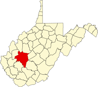
This is a list of the National Register of Historic Places listings in Kanawha County, West Virginia.

National Register of Historic Places listings in King William County, Virginia

This is a list of the National Register of Historic Places listings in King William County, Virginia.

National Register of Historic Places listings in Loudoun County, Virginia

This is a list of the National Register of Historic Places listings in Loudoun County, Virginia.

National Register of Historic Places listings in Prince William County, Virginia

This is a list of the National Register of Historic Places listings in Prince William County, Virginia.

National Register of Historic Places listings in Mecklenburg County, Virginia

This is a list of the National Register of Historic Places listings in Mecklenburg County, Virginia.

National Register of Historic Places listings in Pulaski County, Virginia

This is a list of the National Register of Historic Places listings in Pulaski County, Virginia.

National Register of Historic Places listings in York County, Virginia

This is a list of the National Register of Historic Places listings in York County, Virginia.

National Register of Historic Places listings in Northampton County, Virginia

This is a list of the National Register of Historic Places listings in Northampton County, Virginia.

National Register of Historic Places listings in Surry County, Virginia

This is a list of the National Register of Historic Places listings in Surry County, Virginia.

National Register of Historic Places listings in Scott County, Virginia

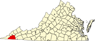
This is a list of the National Register of Historic Places listings in Scott County, Virginia.

National Register of Historic Places listings in Appomattox County, Virginia

This is a list of the National Register of Historic Places listings in Appomattox County, Virginia.

National Register of Historic Places listings in Highland County, Virginia

This is a list of the National Register of Historic Places listings in Highland County, Virginia.

References

  1. The latitude and longitude information provided in this table was derived originally from the National Register Information System, which has been found to be fairly accurate for about 99% of listings. Some locations in this table may have been corrected to current GPS standards.
  2. National Park Service, United States Department of the Interior, "National Register of Historic Places: Weekly List Actions", retrieved March 18, 2022.
  3. Numbers represent an alphabetical ordering by significant words. Various colorings, defined here, differentiate National Historic Landmarks and historic districts from other NRHP buildings, structures, sites or objects.
  4. "National Register Information System". National Register of Historic Places . National Park Service. April 24, 2008.
  5. The eight-digit number below each date is the number assigned to each location in the National Register Information System database, which can be viewed by clicking the number.
  6. Fairfield, Gloucester Co., Slideshow, DHR [slide 6], n.d. Accessed 2016-10-01.
  7. Waterman, Thomas Tileston, and John A. Barrows. Domestic Colonial Architecture of Tidewater Virginia. 1968 hardback reprint ed. New York: Scribner's, 1932, 31.
  8. McCartney, Martha W., and David K. Hazzard. National Register of Historic Places Inventory/Nomination: Gloucester Point Archaeological District. National Park Service, 1980-06-06, 12.
  9. Fonzo, Stephen, et al. National Register of Historic Places Inventory/Nomination: Point Lookout Archaeological Site. National Park Service, 2013-09-13, 25.
  10. Gloucester County Comprehensive Plan, Gloucester County, 2015-11, 3. Accessed 2017-02-04.