National Register of Historic Places listings in Grant County, South Dakota

Last updated

Location of Grant County in South Dakota Map of South Dakota highlighting Grant County.svg
Location of Grant County in South Dakota

This is a list of the National Register of Historic Places listings in Grant County, South Dakota.

Contents

This is intended to be a complete list of the properties and districts on the National Register of Historic Places in Grant County, South Dakota, United States. The locations of National Register properties and districts for which the latitude and longitude coordinates are included below, may be seen in a map. [1]

There are 15 properties and districts listed on the National Register in the county.


    This National Park Service list is complete through NPS recent listings posted June 16, 2023. [2]

Map all coordinates using: OpenStreetMap  
Download coordinates as: KML

Current listings

[3] Name on the Register [4] ImageDate listed [5] Location City or townDescription
1 Big Stone City Hall
Big Stone City Hall Big Stone City Hall NRHP 04000764 Grant County, SD.jpg
Big Stone City Hall
July 28, 2004
(#04000764)
469 Main
45°17′37″N96°27′48″W / 45.293611°N 96.463333°W / 45.293611; -96.463333 (Big Stone City Hall)
Big Stone City
2 Brown Earth Presbyterian Church
Brown Earth Presbyterian Church Brown Earth Church from ESE 1.jpg
Brown Earth Presbyterian Church
August 29, 1984
(#84003288)
Northeast of Stockholm
45°07′20″N96°46′20″W / 45.122156°N 96.772113°W / 45.122156; -96.772113 (Brown Earth Presbyterian Church)
Stockholm
3 First Congregational Church of Milbank
First Congregational Church of Milbank UCC Milbank 1.jpg
First Congregational Church of Milbank
April 19, 1978
(#78002553)
E. 3rd Ave.
45°13′31″N96°37′39″W / 45.225278°N 96.6275°W / 45.225278; -96.6275 (First Congregational Church of Milbank)
Milbank
4 First National Bank of Milbank
First National Bank of Milbank First National Bank Of Milbank NRHP 78002554 Grant County, SD.jpg
First National Bank of Milbank
April 19, 1978
(#78002554)
225 S. Main St.
45°13′13″N96°38′10″W / 45.220278°N 96.636111°W / 45.220278; -96.636111 (First National Bank of Milbank)
Milbank
5 First State Bank Building
First State Bank Building Revillo First State Bank from SE 2.jpg
First State Bank Building
February 26, 1987
(#87000221)
2nd Ave and 4th St [6]
45°00′59″N96°34′17″W / 45.016438°N 96.571482°W / 45.016438; -96.571482 (First State Bank Building)
Revillo
6 Herman Freiwald Barn
Herman Freiwald Barn Herman Freiwald barn and silo from NE 1.jpg
Herman Freiwald Barn
February 19, 2008
(#08000045) [7]
48603 148th St.
45°14′20″N96°28′23″W / 45.238952°N 96.473077°W / 45.238952; -96.473077 (Herman Freiwald Barn)
Big Stone City
7 James A. and Ida Bell Gold House
James A. and Ida Bell Gold House Gold House NRHP 08000046 Grant County, SD.jpg
James A. and Ida Bell Gold House
February 19, 2008
(#08000046)
202 2nd Ave.
45°17′51″N96°27′52″W / 45.2975°N 96.464444°W / 45.2975; -96.464444 (James A. and Ida Bell Gold House)
Big Stone City
8 Grant County Courthouse
Grant County Courthouse Grant County Courthouse NRHP 92001858 Grant County, SD.jpg
Grant County Courthouse
February 10, 1993
(#92001858)
Junction of Park Ave. and Main St.
45°13′03″N96°38′08″W / 45.2175°N 96.635556°W / 45.2175; -96.635556 (Grant County Courthouse)
Milbank
9 Hollands Grist Mill
Hollands Grist Mill SD-Milbank-Hollandsgristmill.JPG
Hollands Grist Mill
February 24, 1981
(#81000573)
U.S. Route 12
45°13′21″N96°37′07″W / 45.2225°N 96.618611°W / 45.2225; -96.618611 (Hollands Grist Mill)
Milbank
10 Emil and Hannah Johnson House
Emil and Hannah Johnson House Emil Johnson House NRHP 08000047 Grant County, SD.jpg
Emil and Hannah Johnson House
February 19, 2008
(#08000047)
117 Diggs Ave.
45°13′39″N96°38′20″W / 45.2275°N 96.638889°W / 45.2275; -96.638889 (Emil and Hannah Johnson House)
Milbank
11 George and Mary Koch Farm
George and Mary Koch Farm George and Mary Koch farm--house from E 1.jpg
George and Mary Koch Farm
February 19, 2008
(#08000048)
14849 474th Ave.
45°13′48″N96°43′18″W / 45.2299°N 96.7217°W / 45.2299; -96.7217 (George and Mary Koch Farm)
Twin Brooks
12 Lebanon Lutheran Church
Lebanon Lutheran Church Lebanon Church (Grant Co, SD) from SW 2.jpg
Lebanon Lutheran Church
September 15, 1977
(#77001244)
146 St and 452 Ave [8]
45°16′02″N97°09′52″W / 45.267249°N 97.164403°W / 45.267249; -97.164403 (Lebanon Lutheran Church)
Summit
13 Milbank Carnegie Library
Milbank Carnegie Library Milbank Carnegie Library2 NRHP 78002555 Gtant County, SD.jpg
Milbank Carnegie Library
November 21, 1978
(#78002555)
S. 3rd Ave.
45°13′31″N96°38′17″W / 45.225278°N 96.638056°W / 45.225278; -96.638056 (Milbank Carnegie Library)
Milbank
14 Ole Nelson Barn
Ole Nelson Barn Ole Nelson barn (Grant County, South Dakota) from NW 1.jpg
Ole Nelson Barn
February 19, 2008
(#08000049)
14674 454th Ave.
45°15′30″N97°07′20″W / 45.258433°N 97.122302°W / 45.258433; -97.122302 (Ole Nelson Barn)
Summit
15 Swedish Lutheran Church of Strandburg
Swedish Lutheran Church of Strandburg Tabor Church, Strandburg, from SW 1.jpg
Swedish Lutheran Church of Strandburg
February 17, 1978
(#78002556)
162 St and 472 Ave [9]
45°02′27″N96°45′38″W / 45.040823°N 96.760493°W / 45.040823; -96.760493 (Swedish Lutheran Church of Strandburg)
Strandburg

See also

Related Research Articles

<span class="mw-page-title-main">National Register of Historic Places listings in Webster County, Nebraska</span>

This is a list of the National Register of Historic Places listings in Webster County, Nebraska. It is intended to be a complete list of the properties and districts on the National Register of Historic Places in Webster County, Nebraska, United States. The locations of National Register properties and districts for which the latitude and longitude coordinates are included below, may be seen in a map.

<span class="mw-page-title-main">National Register of Historic Places listings in Millard County, Utah</span>

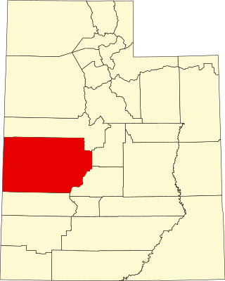
This is a list of the National Register of Historic Places listings in Millard County, Utah.

<span class="mw-page-title-main">National Register of Historic Places listings in Aurora County, South Dakota</span>

This is a list of the National Register of Historic Places listings in Aurora County, South Dakota.

<span class="mw-page-title-main">National Register of Historic Places listings in Beadle County, South Dakota</span>

This is a list of the National Register of Historic Places listings in Beadle County, South Dakota.

<span class="mw-page-title-main">National Register of Historic Places listings in Bon Homme County, South Dakota</span>

This is a list of the National Register of Historic Places listings in Bon Homme County, South Dakota.

<span class="mw-page-title-main">National Register of Historic Places listings in Brookings County, South Dakota</span>

This is a list of the National Register of Historic Places listings in Brookings County, South Dakota.

<span class="mw-page-title-main">National Register of Historic Places listings in Brown County, South Dakota</span>

This is a list of the National Register of Historic Places listings in Brown County, South Dakota.

<span class="mw-page-title-main">National Register of Historic Places listings in Pennington County, South Dakota</span>

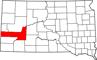
This is a list of the National Register of Historic Places listings in Pennington County, South Dakota.

<span class="mw-page-title-main">National Register of Historic Places listings in Yankton County, South Dakota</span>

This is a list of the National Register of Historic Places listings in Yankton County, South Dakota.

<span class="mw-page-title-main">National Register of Historic Places listings in Charles Mix County, South Dakota</span>

This is a list of the National Register of Historic Places listings in Charles Mix County, South Dakota.

<span class="mw-page-title-main">National Register of Historic Places listings in Clay County, South Dakota</span>

This is a list of the National Register of Historic Places listings in Clay County, South Dakota.

<span class="mw-page-title-main">National Register of Historic Places listings in Davison County, South Dakota</span>

This is a list of the National Register of Historic Places listings in Davison County, South Dakota.

<span class="mw-page-title-main">National Register of Historic Places listings in Gregory County, South Dakota</span>

This is a list of the National Register of Historic Places listings in Gregory County, South Dakota.

<span class="mw-page-title-main">National Register of Historic Places listings in Jerauld County, South Dakota</span>

This is a list of the National Register of Historic Places listings in Jerauld County, South Dakota.

<span class="mw-page-title-main">National Register of Historic Places listings in Walworth County, South Dakota</span>

This is a list of the National Register of Historic Places listings in Walworth County, South Dakota.

<span class="mw-page-title-main">National Register of Historic Places listings in Union County, South Dakota</span>

This is a list of the National Register of Historic Places listings in Union County, South Dakota.

<span class="mw-page-title-main">National Register of Historic Places listings in Lincoln County, South Dakota</span>

This is a list of the National Register of Historic Places listings in Lincoln County, South Dakota.

<span class="mw-page-title-main">National Register of Historic Places listings in Turner County, South Dakota</span>

This is a list of the National Register of Historic Places listings in Turner County, South Dakota.

<span class="mw-page-title-main">National Register of Historic Places listings in Robeson County, North Carolina</span>

This list includes properties and districts listed on the National Register of Historic Places in Robeson County, North Carolina. Click the "Map of all coordinates" link to the right to view a Google map of all properties and districts with latitude and longitude coordinates in the table below.

<span class="mw-page-title-main">National Register of Historic Places listings in Cooper County, Missouri</span>

This is a list of the National Register of Historic Places listings in Cooper County, Missouri.

References

  1. The latitude and longitude information provided in this table was derived originally from the National Register Information System, which has been found to be fairly accurate for about 99% of listings. Some locations in this table may have been corrected to current GPS standards.
  2. National Park Service, United States Department of the Interior, "National Register of Historic Places: Weekly List Actions", retrieved June 16, 2023.
  3. Numbers represent an alphabetical ordering by significant words. Various colorings, defined here, differentiate National Historic Landmarks and historic districts from other NRHP buildings, structures, sites or objects.
  4. "National Register Information System". National Register of Historic Places . National Park Service. April 24, 2008.
  5. The eight-digit number below each date is the number assigned to each location in the National Register Information System database, which can be viewed by clicking the number.
  6. See 2017 photo, including street sign
  7. Listed on NRHP as "Herman Friewald Barn"; but name is spelled "Freiwald" throughout nominating form
  8. See 2017 photo, including street sign
  9. See 2017 photo, including street sign