National Register of Historic Places listings in Hancock County, Georgia

Last updated

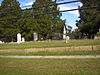
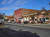
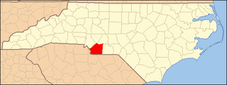
This is a list of properties and districts in Hancock County, Georgia that are listed on the National Register of Historic Places (NRHP).

Map all coordinates using: OpenStreetMap  
Download coordinates as: KML  ·  GPX
This National Park Service list is complete through NPS recent listings posted November 15, 2019. [1]

Current listings

[2] Name on the RegisterImageDate listed [3] Location City or townDescription
1 Camilla-Zack Community Center District December 2, 1974
(#74000685)
Rte. 1
33°24′41″N82°56′29″W / 33.411342°N 82.941309°W / 33.411342; -82.941309 (Camilla-Zack Community Center District)
Mayfield vic.(article in draft--doncram)
2 Cheely-Coleman House
Cheely-Coleman House Thomas Cheely House, County Road S-1098, Shoals vicinity (Hancock County, Georgia).jpg
Cheely-Coleman House
October 29, 1976
(#76000638)
S of Jewell off GA 123 at Ogeechee River
33°15′07″N82°45′35″W / 33.251944°N 82.759722°W / 33.251944; -82.759722 (Cheely-Coleman House)
Jewell
3 Glen Mary May 8, 1974
(#74000687)
Linton Rd., S of Sparta
33°10′40″N83°00′06″W / 33.1778°N 83.0016°W / 33.1778; -83.0016 (Glen Mary)
Sparta
4 Hurt-Rives Plantation August 8, 1996
(#96000874)
Off Rives Rd., northwest of Sparta [4]
33°18′34″N83°07′08″W / 33.3094°N 83.1189°W / 33.3094; -83.1189 (Hurt-Rives Plantation)
Sparta
5 John S. Jackson Plantation House and Outbuildings June 28, 1984
(#84001116)
Off GA 16
33°24′17″N83°05′18″W / 33.404722°N 83.088333°W / 33.404722; -83.088333 (John S. Jackson Plantation House and Outbuildings)
White Plains
6 Jewell Historic District
Jewell Historic District Jewell Historic District.JPG
Jewell Historic District
May 14, 1979
(#79003106)
GA 248 and GA 16
33°17′41″N82°46′58″W / 33.294722°N 82.782778°W / 33.294722; -82.782778 (Jewell Historic District)
Jewell
7 Linton Historic District
Linton Historic District Antebellum house, Linton, Georgia.JPG
Linton Historic District
June 18, 1975
(#75000597)
Town of Linton and its environs
33°06′52″N82°58′58″W / 33.114444°N 82.982778°W / 33.114444; -82.982778 (Linton Historic District)
Linton
8 Pearson-Boyer Plantation April 12, 1993
(#93000236)
Pearson Chapel Rd.
33°11′06″N83°01′00″W / 33.18489°N 83.01665°W / 33.18489; -83.01665 (Pearson-Boyer Plantation)
Sparta
9 Rockby July 12, 1978
(#78000988)
NE of Sparta off GA 16
33°18′11″N82°56′26″W / 33.303056°N 82.940556°W / 33.303056; -82.940556 (Rockby)
Sparta
10 Shivers-Simpson House June 22, 1970
(#70000207)
N of Jewell on Mayfield Rd.
33°18′30″N82°47′30″W / 33.308333°N 82.791667°W / 33.308333; -82.791667 (Shivers-Simpson House)
Jewell
11 Sparta Cemetery
Sparta Cemetery Sparta Cemetery 2.JPG
Sparta Cemetery
June 22, 2001
(#01000647)
N of jct. of Hamilton and Boland Sts.
33°16′43″N82°58′26″W / 33.278611°N 82.973889°W / 33.278611; -82.973889 (Sparta Cemetery)
Sparta
12 Sparta Historic District
Sparta Historic District Sparta Historic District 2.JPG
Sparta Historic District
April 16, 1974
(#74000686)
Roughly bounded by Hamilton, Elm, W, and Burwell Sts.
33°16′36″N82°58′36″W / 33.276667°N 82.976667°W / 33.276667; -82.976667 (Sparta Historic District)
Sparta The old courthouse is a contributing property that is in peril, see Georgia Trust. Includes the Rossiter-Little House

Related Research Articles

National Register of Historic Places listings in Cattaraugus County, New York Wikimedia list article

This is intended to be a complete list of properties and districts listed on the National Register of Historic Places in Cattaraugus County, New York. The locations of National Register properties and districts for which the latitude and longitude coordinates are included below, may be seen in a map.

National Register of Historic Places listings in Jefferson County, New York Wikimedia list article

List of the National Register of Historic Places listings in Jefferson County, New York

National Register of Historic Places listings in Oneida County, New York Wikimedia list article

List of the National Register of Historic Places listings in Oneida County, New York

National Register of Historic Places listings in Onondaga County, New York Wikimedia list article

This is a list of the properties and districts listed on the National Register of Historic Places listings in Onondaga County, New York. The locations of National Register properties and districts may be seen in a map by clicking on "Map of all coordinates". There are 159 properties and districts listed on the National Register in the county. Of those, 54 are outside the city of Syracuse, and are listed here, while the rest are covered in National Register of Historic Places listings in Syracuse, New York. One property, the New York State Barge Canal, spans both the city and the remainder of the county.

National Register of Historic Places listings in Ontario County, New York Wikimedia list article

List of the National Register of Historic Places listings in Ontario County, New York

National Register of Historic Places listings in Madison County, New York Wikimedia list article

List of the National Register of Historic Places listings in Madison County, New York

National Register of Historic Places listings in Fayette County, Pennsylvania Wikimedia list article

This is a list of the National Register of Historic Places listings in Fayette County, Pennsylvania.

This is a list of properties and historic districts in Milton, Massachusetts, that are listed on the National Register of Historic Places.

National Register of Historic Places listings in Centre County, Pennsylvania Wikimedia list article

This is a list of the National Register of Historic Places listings in Centre County, Pennsylvania.

National Register of Historic Places listings in Spartanburg County, South Carolina Wikimedia list article

This is a list of the National Register of Historic Places listings in Spartanburg County, South Carolina.

National Register of Historic Places listings in Owyhee County, Idaho Wikimedia list article

This is a list of the National Register of Historic Places listings in Owyhee County, Idaho.

National Register of Historic Places listings in Halifax County, North Carolina Wikimedia list article

This list includes properties and districts listed on the National Register of Historic Places in Halifax County, North Carolina. Click the "Map of all coordinates" link to the right to view an online map of all properties and districts with latitude and longitude coordinates in the table below.

National Register of Historic Places listings in Burke County, North Carolina Wikimedia list article

This list includes properties and districts listed on the National Register of Historic Places in Burke County, North Carolina. Click the "Map of all coordinates" link to the right to view an online map of all properties and districts with latitude and longitude coordinates in the table below.

National Register of Historic Places listings in Johnston County, North Carolina Wikimedia list article

This list includes properties and districts listed on the National Register of Historic Places in Johnston County, North Carolina. Click the "Map of all coordinates" link to the right to view Google Maps of all properties and districts with latitude and longitude coordinates in the table below.

National Register of Historic Places listings in Henderson County, North Carolina Wikimedia list article

This list includes properties and districts listed on the National Register of Historic Places in Henderson County, North Carolina. Click the "Map of all coordinates" link to the right to view an online map of all properties and districts with latitude and longitude coordinates in the table below.

National Register of Historic Places listings in Vance County, North Carolina Wikimedia list article

This list includes properties and districts listed on the National Register of Historic Places in Vance County, North Carolina. Click the "Map of all coordinates" link to the right to view a Google map of all properties and districts with latitude and longitude coordinates in the table below.

National Register of Historic Places listings in Lee County, North Carolina Wikimedia list article

This list includes properties and districts listed on the National Register of Historic Places in Lee County, North Carolina. Click the "Map of all coordinates" link to the right to view an online map of all properties and districts with latitude and longitude coordinates in the table below.

National Register of Historic Places listings in Northampton County, North Carolina Wikimedia list article

This list includes properties and districts listed on the National Register of Historic Places in Northampton County, North Carolina. Click the "Map of all coordinates" link to the right to view a Google map of all properties and districts with latitude and longitude coordinates in the table below.

National Register of Historic Places listings in Carteret County, North Carolina Wikimedia list article

This list includes properties and districts listed on the National Register of Historic Places in Carteret County, North Carolina. Click the "Map of all coordinates" link to the right to view a Google map of all properties and districts with latitude and longitude coordinates in the table below.

National Register of Historic Places listings in Union County, North Carolina Wikimedia list article

This list includes properties and districts listed on the National Register of Historic Places in Union County, North Carolina. Click the "Map of all coordinates" link to the right to view a Google map of all properties and districts with latitude and longitude coordinates in the table below.

References

  1. "National Register of Historic Places: Weekly List Actions". National Park Service, United States Department of the Interior. Retrieved on November 15, 2019.
  2. Numbers represent an ordering by significant words. Various colorings, defined here, differentiate National Historic Landmarks and historic districts from other NRHP buildings, structures, sites or objects.
  3. The eight-digit number below each date is the number assigned to each location in the National Register Information System database, which can be viewed by clicking the number.
  4. Location derived from its coordinates; the NRIS provides coordinates but lists the property as "Address Restricted"