This is a list of sites in Minnesota which are included in the National Register of Historic Places. There are more than 1,700 properties and historic districts listed on the NRHP; each of Minnesota's 87 counties has at least 2 listings. Twenty-two sites are also National Historic Landmarks.

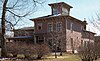
Schech's Mill is a historic mill in Houston County, Minnesota, United States. It is one of three watermills in Minnesota still operating solely with water power and the only one to have its original millstones. Built by John Blinn in 1876, it was purchased by a Minneapolis miller, Michael Schech who had emigrated from Bavaria, Germany. The mill produced cornmeal, rye buckwheat, wheat flour, graham flour, and whole wheat cereal, which was sold in Caledonia and Houston, Minnesota. Schech's Mill is unique in the state for retaining intact and operable machinery from the 1870s, after the middlings purifier had been introduced but before millstones were supplanted by roller mills. In 1922, a concrete dam was built to replace the original wooden one.

This list is of the properties and historic districts which are designated on the National Register of Historic Places or that were formerly so designated, in Hennepin County, Minnesota; there are 190 entries as of April 2023. A significant number of these properties are a result of the establishment of Fort Snelling, the development of water power at Saint Anthony Falls, and the thriving city of Minneapolis that developed around the falls. Many historic sites outside the Minneapolis city limits are associated with pioneers who established missions, farms, and schools in areas that are now suburbs in that metropolitan area.

This is a list of the National Register of Historic Places listings in Rice County, Minnesota. It is intended to be a complete list of the properties and districts on the National Register of Historic Places in Rice County, Minnesota, United States. The locations of National Register properties and districts for which the latitude and longitude coordinates are included below, may be seen in an online map.

This is a list of the National Register of Historic Places listings in Goodhue County, Minnesota. It is intended to be a complete list of the properties and districts on the National Register of Historic Places in Goodhue County, Minnesota, United States. The locations of National Register properties and districts for which the latitude and longitude coordinates are included below, may be seen in an online map.

This is a list of the National Register of Historic Places listings in Saint Louis County, Minnesota. It is intended to be a complete list of the properties and districts on the National Register of Historic Places in Saint Louis County, Minnesota, United States. The locations of National Register properties and districts for which the latitude and longitude coordinates are included below, may be seen in an online map.

This is a list of the National Register of Historic Places listings in Stearns County, Minnesota. It is intended to be a complete list of the properties and districts on the National Register of Historic Places in Stearns County, Minnesota, United States. The locations of National Register properties and districts for which the latitude and longitude coordinates are included below, may be seen in an online map.
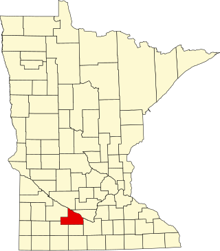
This is a list of the National Register of Historic Places listings in Brown County, Minnesota. It is intended to be a complete list of the properties and districts on the National Register of Historic Places in Brown County, Minnesota, United States. The locations of National Register properties and districts for which the latitude and longitude coordinates are included below, may be seen in an online map.

This is a list of the National Register of Historic Places listings in Crow Wing County, Minnesota. It is intended to be a complete list of the properties and districts on the National Register of Historic Places in Crow Wing County, Minnesota, United States. The locations of National Register properties and districts for which the latitude and longitude coordinates are included below, may be seen in an online map.

This is a list of the National Register of Historic Places listings in Olmsted County, Minnesota. It is intended to be a complete list of the properties and districts on the National Register of Historic Places in Olmsted County, Minnesota, United States. The locations of National Register properties and districts for which the latitude and longitude coordinates are included below, may be seen in an online map.

This is a list of the National Register of Historic Places listings in Winona County, Minnesota. It is intended to be a complete list of the properties and districts on the National Register of Historic Places in Winona County, Minnesota, United States. The locations of National Register properties and districts for which the latitude and longitude coordinates are included below, may be seen in an online map.

This is a list of the National Register of Historic Places listings in Fillmore County, Minnesota. It is intended to be a complete list of the properties and districts on the National Register of Historic Places in Fillmore County, Minnesota, United States. The locations of National Register properties and districts for which the latitude and longitude coordinates are included below, may be seen in an online map.

This is a list of the National Register of Historic Places listings in Itasca County, Minnesota. It is intended to be a complete list of the properties and districts on the National Register of Historic Places in Itasca County, Minnesota, United States. The locations of National Register properties and districts for which the latitude and longitude coordinates are included below, may be seen in an online map.

This is a list of the National Register of Historic Places listings in Washington County, Minnesota. It is intended to be a complete list of the properties and districts on the National Register of Historic Places in Washington County, Minnesota, United States. The locations of National Register properties and districts for which the latitude and longitude coordinates are included below, may be seen in an online map.

This is a list of the National Register of Historic Places listings in Rock County, Minnesota. It is intended to be a complete list of the properties and districts on the National Register of Historic Places in Rock County, Minnesota, United States. The locations of National Register properties and districts for which the latitude and longitude coordinates are included below, may be seen in an online map.

This is a list of the National Register of Historic Places listings in Cass County, Minnesota. It is intended to be a complete list of the properties and districts on the National Register of Historic Places in Cass County, Minnesota, United States. The locations of National Register properties and districts for which the latitude and longitude coordinates are included below, may be seen in an online map.

This is a list of the National Register of Historic Places listings in Pope County, Minnesota. It is intended to be a complete list of the properties and districts on the National Register of Historic Places in Pope County, Minnesota, United States. The locations of National Register properties and districts for which the latitude and longitude coordinates are included below, may be seen in an online map.

This is a list of the National Register of Historic Places listings in Aitkin County, Minnesota.

This is a list of the National Register of Historic Places listings in Steele County, Minnesota. It is intended to be a complete list of the properties and districts on the National Register of Historic Places in Steele County, Minnesota, United States. The locations of National Register properties and districts for which the latitude and longitude coordinates are included below, may be seen in an online map.

This is a list of the National Register of Historic Places listings in Dodge County, Minnesota. It is intended to be a complete list of the properties and districts on the National Register of Historic Places in Dodge County, Minnesota, United States. The locations of National Register properties and districts for which the latitude and longitude coordinates are included below, may be seen in an online map.