National Register of Historic Places listings in Iron County, Utah

Last updated

Location of Iron County in Utah Map of Utah highlighting Iron County.svg
Location of Iron County in Utah

This is a list of the National Register of Historic Places listings in Iron County, Utah.

Contents

This is intended to be a complete list of the properties and districts on the National Register of Historic Places in Iron County, Utah, United States. Latitude and longitude coordinates are provided for many National Register properties and districts; these locations may be seen together in a map. [1]

There are 18 properties and districts listed on the National Register in the county. Two other sites in the county were once listed on the Register, but have since been removed.


    This National Park Service list is complete through NPS recent listings posted August 11, 2023. [2]

Map all coordinates using: OpenStreetMap

Current listings

[3] Name on the Register [4] ImageDate listed [5] Location City or townDescription
1 Caretaker's Cabin
Caretaker's Cabin Cedar Breaks NM Caretaker Cabin NPS.jpg
Caretaker's Cabin
August 4, 1983
(#83004385)
Off State Route 14
37°36′55″N112°50′12″W / 37.615278°N 112.836667°W / 37.615278; -112.836667 (Caretaker's Cabin)
Cedar City
2 Cedar City Historic District
Cedar City Historic District Cedar City District.PNG
Cedar City Historic District
July 7, 2004
(#04000677)
Roughly bounded by 100 West and 300 West, College Ave., and 400 South
37°40′23″N113°03′51″W / 37.673056°N 113.064167°W / 37.673056; -113.064167 (Cedar City Historic District)
Cedar City
3 Cedar City Railroad Depot
Cedar City Railroad Depot Rear View of Cedar City Railroad Depot.jpg
Cedar City Railroad Depot
August 9, 1984
(#84002184)
220 N. Main St.
37°40′53″N113°03′41″W / 37.681389°N 113.061389°W / 37.681389; -113.061389 (Cedar City Railroad Depot)
Cedar City
4 Ensign-Smith House
Ensign-Smith House Ensign-Smith House 1982 - Paragonah Utah.jpeg
Ensign-Smith House
May 19, 1983
(#83004400)
96 N. Main St.
37°53′12″N112°46′26″W / 37.886667°N 112.773889°W / 37.886667; -112.773889 (Ensign-Smith House)
Paragonah
5 Evans Mound (42IN40) October 24, 1985
(#85003387)
Address Restricted [6]
Summit
6 Gold Spring July 21, 1977
(#77001305)
Address Restricted [6]
Modena
7 Long Flat Site November 1, 1979
(#79002496)
Address Restricted [6]
Parowan
8 William and Julia Lyman House
William and Julia Lyman House Lyman House Parowan Utah.jpeg
William and Julia Lyman House
April 6, 2000
(#00000355)
191 S. Main St.
37°50′22″N112°49′35″W / 37.839444°N 112.826389°W / 37.839444; -112.826389 (William and Julia Lyman House)
Parowan
9 Meeks-Green Farmstead
Meeks-Green Farmstead Meeks-Green Farmstead Parowan Utah.jpeg
Meeks-Green Farmstead
April 15, 1994
(#94000295)
Approximately 40 N. 400 West
37°50′34″N112°50′08″W / 37.842778°N 112.835556°W / 37.842778; -112.835556 (Meeks-Green Farmstead)
Parowan
10 Modena Elementary School
Modena Elementary School Modena Elementary School.jpg
Modena Elementary School
April 1, 1985
(#85000806)
About 150 N. Main St.
37°48′00″N113°55′29″W / 37.8°N 113.924722°W / 37.8; -113.924722 (Modena Elementary School)
Modena
11 Old Irontown
Old Irontown Old Iron Town, Utah.jpg
Old Irontown
May 14, 1971
(#71000843)
About 22 miles (35 km) west of Cedar City, 3 miles (4.8 km) south of State Route 56
37°36′00″N113°26′56″W / 37.6°N 113.448889°W / 37.6; -113.448889 (Old Irontown)
Cedar City
12 Old Main and Science Buildings
Old Main and Science Buildings Southern Utah University 1.jpg
Old Main and Science Buildings
August 21, 1984
(#84002186)
Southern Utah University campus
37°40′32″N113°04′03″W / 37.675556°N 113.0675°W / 37.675556; -113.0675 (Old Main and Science Buildings)
Cedar City
13 Daniel R. and Sophia G. Page House
Daniel R. and Sophia G. Page House Page Ranch House as of 2017.jpg
Daniel R. and Sophia G. Page House
May 9, 1985
(#85000961)
Richie Flat at the western edge of the Harmony Mountains
37°34′03″N113°25′24″W / 37.5675°N 113.423333°W / 37.5675; -113.423333 (Daniel R. and Sophia G. Page House)
Newcastle
14 Parowan Gap Petroglyphs
Parowan Gap Petroglyphs Parowan Gap.jpg
Parowan Gap Petroglyphs
October 10, 1975
(#75001806)
10.5 miles (16.9 km) west of Main Street in Parowan [7]
37°54′35″N112°59′07″W / 37.909722°N 112.985278°W / 37.909722; -112.985278 (Parowan Gap Petroglyphs)
Parowan
15 Parowan Meetinghouse
Parowan Meetinghouse Parowan Utah Church.jpg
Parowan Meetinghouse
May 6, 1976
(#76001818)
Center block of Main St., between Center and 100 South St.
37°50′28″N112°49′41″W / 37.841111°N 112.828056°W / 37.841111; -112.828056 (Parowan Meetinghouse)
Parowan
16 Jesse N. Smith House
Jesse N. Smith House Jesse N. Smith House as of 2017.jpg
Jesse N. Smith House
June 20, 1975
(#75001807)
45 W. 100 South
37°50′24″N112°49′39″W / 37.84°N 112.8275°W / 37.84; -112.8275 (Jesse N. Smith House)
Parowan
17 US Post Office-Cedar City Main
US Post Office-Cedar City Main Front of Historic US Post Office in Cedar City.jpg
US Post Office-Cedar City Main
November 27, 1989
(#89001993)
10 N. Main St.
37°40′39″N113°03′39″W / 37.6775°N 113.060833°W / 37.6775; -113.060833 (US Post Office-Cedar City Main)
Cedar City Now houses city offices
18 Visitor Center
Visitor Center Cedar Breaks NM Visitor Center NPS.jpg
Visitor Center
August 4, 1983
(#83004386)
Off State Route 14
37°37′09″N112°50′12″W / 37.619167°N 112.836667°W / 37.619167; -112.836667 (Visitor Center)
Cedar City

Former listing

[3] Name on the RegisterImageDate listedDate removedLocationCity or townDescription
1 Joseph S. Hunter House February 11, 1982
(#82004126)
February 21, 200786 E. Center St.(Original location. Now located at:)
37°41′20″N113°03′48″W / 37.6888515°N 113.063228°W / 37.6888515; -113.063228 (Joseph S. Hunter House)
Cedar City Delisted when the house was moved to Iron Mission State Park. [8]
2 George H. Wood House November 14, 1978
(#78002662)
August 15, 2023432 N. Main St.
37°41′06″N113°03′39″W / 37.685°N 113.060833°W / 37.685; -113.060833 (George H. Wood House)
Cedar City

See also

Related Research Articles

<span class="mw-page-title-main">National Register of Historic Places listings in Daggett County, Utah</span>

This is a list of the National Register of Historic Places listings in Daggett County, Utah.

<span class="mw-page-title-main">National Register of Historic Places listings in Carbon County, Utah</span>

This is a list of the National Register of Historic Places listings in Carbon County, Utah.

<span class="mw-page-title-main">National Register of Historic Places listings in Davis County, Utah</span>

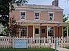
This is a list of the National Register of Historic Places listings in Davis County, Utah.

<span class="mw-page-title-main">National Register of Historic Places listings in Box Elder County, Utah</span>

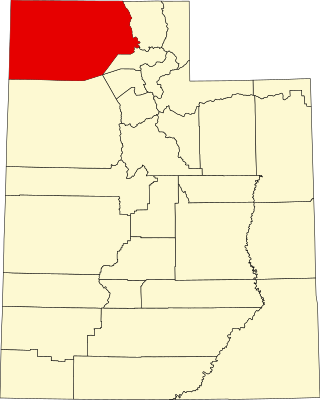
This is a list of the National Register of Historic Places listings in Box Elder County, Utah.

<span class="mw-page-title-main">National Register of Historic Places listings in Beaver County, Utah</span>

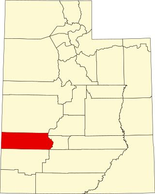
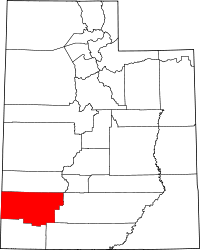
This is a list of the National Register of Historic Places listings in Beaver County, Utah.

<span class="mw-page-title-main">National Register of Historic Places listings in Duchesne County, Utah</span>

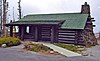
This is a list of the National Register of Historic Places listings in Duchesne County, Utah.

<span class="mw-page-title-main">National Register of Historic Places listings in Emery County, Utah</span>

This is a list of the National Register of Historic Places listings in Emery County, Utah.

<span class="mw-page-title-main">National Register of Historic Places listings in Grand County, Utah</span>

This is a list of the National Register of Historic Places listings in Grand County, Utah.

<span class="mw-page-title-main">National Register of Historic Places listings in Garfield County, Utah</span>

This is a list of the National Register of Historic Places listings in Garfield County, Utah.

<span class="mw-page-title-main">National Register of Historic Places listings in Juab County, Utah</span>

This is a list of the National Register of Historic Places listings in Juab County, Utah.

<span class="mw-page-title-main">National Register of Historic Places listings in Morgan County, Utah</span>

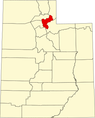
This is a list of the National Register of Historic Places listings in Morgan County, Utah.

<span class="mw-page-title-main">National Register of Historic Places listings in Kane County, Utah</span>

This is a list of the National Register of Historic Places listings in Kane County, Utah.

<span class="mw-page-title-main">National Register of Historic Places listings in Millard County, Utah</span>

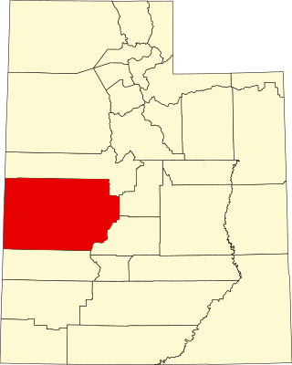
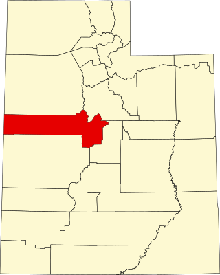
This is a list of the National Register of Historic Places listings in Millard County, Utah.

<span class="mw-page-title-main">National Register of Historic Places listings in Tooele County, Utah</span>

This is a list of the National Register of Historic Places listings in Tooele County, Utah.

<span class="mw-page-title-main">National Register of Historic Places listings in Sevier County, Utah</span>

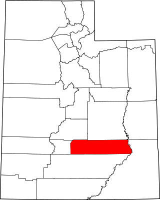
This is a list of the National Register of Historic Places listings in Sevier County, Utah.

<span class="mw-page-title-main">National Register of Historic Places listings in San Juan County, Utah</span>

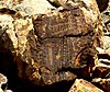
This is a list of the National Register of Historic Places listings in San Juan County, Utah.

<span class="mw-page-title-main">National Register of Historic Places listings in Wayne County, Utah</span>

This is a list of the National Register of Historic Places listings in Wayne County, Utah.

<span class="mw-page-title-main">National Register of Historic Places listings in Uintah County, Utah</span>

This is a list of the National Register of Historic Places listings in Uintah County, Utah.

<span class="mw-page-title-main">National Register of Historic Places listings in Utah County, Utah</span>

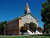
This is a list of the National Register of Historic Places listings in Utah County, Utah.

This is a list of the National Register of Historic Places listings in Zion National Park.

References

  1. The latitude and longitude information provided in this table was derived originally from the National Register Information System, which has been found to be fairly accurate for about 99% of listings. Some locations in this table may have been corrected to current GPS standards.
  2. National Park Service, United States Department of the Interior, "National Register of Historic Places: Weekly List Actions", retrieved August 11, 2023.
  3. 1 2 Numbers represent an alphabetical ordering by significant words. Various colorings, defined here, differentiate National Historic Landmarks and historic districts from other NRHP buildings, structures, sites or objects.
  4. "National Register Information System". National Register of Historic Places . National Park Service. April 24, 2008.
  5. The eight-digit number below each date is the number assigned to each location in the National Register Information System database, which can be viewed by clicking the number.
  6. 1 2 3 Some listings on the NRHP are highly sensitive sites and may be subject to looting or vandalism. The NRHP lists this site as "Address Restricted."
  7. "The Parowan Gap".
  8. "Patience a virtue with efforts to move historic house". The Spectrum (Utah) . December 10, 2005. p. 9. Retrieved August 30, 2022 via Newspapers.com.

Commons-logo.svg Media related to National Register of Historic Places in Iron County, Utah at Wikimedia Commons