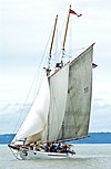
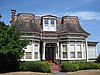
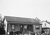
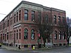
[5] Name on the Register [6] Image Date listed [7] Location City or town Description 1 Adventuress Adventuress April 11, 1989 (# 89001067 Sound Experience, PO Box 1390 47°38′06″N 122°19′39″W / 47.635°N 122.3275°W / 47.635; -122.3275 (Adventuress Port Townsend 2 Frank Bartlett House Frank Bartlett House April 24, 1973 (# 73001870 314 Polk St. 48°06′54″N 122°45′27″W / 48.115°N 122.7575°W / 48.115; -122.7575 (Frank Bartlett House ) Port Townsend 3 Henry Bash House Henry Bash House May 16, 1985 (# 85001099 718 F St. 48°07′17″N 122°46′09″W / 48.1214°N 122.7692°W / 48.1214; -122.7692 (Henry Bash House ) Port Townsend 4 Senator William Bishop House and Office Senator William Bishop House and Office October 10, 1984 (# 84000099 Chimacum-Center Rd. 48°00′39″N 122°46′05″W / 48.0108°N 122.7681°W / 48.0108; -122.7681 (Senator William Bishop House and Office ) Chimacum 5 Botten Cabin Botten Cabin July 13, 2007 (# 07000729 20.9 miles (33.6 km) from Whiskey Bend Trailhead on the Elwha River Trail 47°45′50″N 123°27′16″W / 47.7639°N 123.4544°W / 47.7639; -123.4544 (Botten Cabin ) Port Angeles 6 Chimacum Post Office Chimacum Post Office July 14, 1983 (# 83003323 Chimacum-Center Rd. 48°00′39″N 122°46′01″W / 48.0108°N 122.7669°W / 48.0108; -122.7669 (Chimacum Post Office ) Chimacum 7 Christian Congregation Church of Port Ludlow Christian Congregation Church of Port Ludlow January 28, 2021 (# 100006061 11 Werner Rd. 47°56′12″N 122°42′02″W / 47.9368°N 122.7006°W / 47.9368; -122.7006 (Christian Congregation Church of Port Ludlow ) Port Ludlow 8 City Hall City Hall May 14, 1971 (# 71000868 Water and Madison Sts. 48°06′58″N 122°45′07″W / 48.1161°N 122.7519°W / 48.1161; -122.7519 (City Hall ) Port Townsend 9 Coleman-Furlong House Coleman-Furlong House May 16, 1985 (# 85001100 1253 Umatilla Ave. 48°07′29″N 122°47′22″W / 48.1247°N 122.7894°W / 48.1247; -122.7894 (Coleman-Furlong House ) Port Townsend 10 Dodger Point Fire Lookout Dodger Point Fire Lookout July 13, 2007 (# 07000736 Mile 13 of Dodger Point Trail, about 17.2 miles (27.7 km) south of Port Angeles , in Olympic National Park 47°52′27″N 123°30′36″W / 47.8741°N 123.5100°W / 47.8741; -123.5100 (Dodger Point Fire Lookout ) Port Angeles 11 Duckabush River Bridge Duckabush River Bridge July 16, 1982 (# 82004219 Spans Duckabush River 47°41′25″N 122°53′52″W / 47.6903°N 122.8978°W / 47.6903; -122.8978 (Duckabush River Bridge ) Duckabush Historic Bridges and Tunnels in Washington TR 12 Joel Edwards House Joel Edwards House May 16, 1985 (# 85001101 913 25th St. 48°07′05″N 122°47′09″W / 48.1181°N 122.7858°W / 48.1181; -122.7858 (Joel Edwards House ) Port Townsend 13 Elk Lick Lodge Upload image July 13, 2007 (# 07000734 13 miles (21 km) from Whiskey Bend Trailhead on the Elwha River Trail 47°51′26″N 123°28′09″W / 47.8572°N 123.4692°W / 47.8572; -123.4692 (Elk Lick Lodge ) Port Angeles 14 Enchanted Valley Chalet Enchanted Valley Chalet July 13, 2007 (# 07000737 13 miles (21 km) upriver from Graves Cr. Trailhead 47°40′31″N 123°23′21″W / 47.6753°N 123.3892°W / 47.6753; -123.3892 (Enchanted Valley Chalet ) Port Angeles 15 Thomas Fitzgerald House Thomas Fitzgerald House May 16, 1985 (# 85001102 832 T St. 48°07′50″N 122°45′49″W / 48.1306°N 122.7636°W / 48.1306; -122.7636 (Thomas Fitzgerald House ) Port Townsend 16 Fort Flagler Fort Flagler May 3, 1976 (# 76001882 Southeast of Port Townsend on Marrowstone Island 48°05′48″N 122°40′25″W / 48.0967°N 122.6736°W / 48.0967; -122.6736 (Fort Flagler ) Port Townsend Now a Washington State Park. 17 Fort Worden Fort Worden March 15, 1974 (# 74001954 Cherry and W Sts. 48°08′20″N 122°45′58″W / 48.1389°N 122.7661°W / 48.1389; -122.7661 (Fort Worden ) Port Townsend Also a Washington State Park. 18 Capt. Enoch S. Fowler House Capt. Enoch S. Fowler House September 29, 1970 (# 70000635 Corner of Polk and Washington Sts. 48°06′50″N 122°45′35″W / 48.1139°N 122.7597°W / 48.1139; -122.7597 (Capt. Enoch S. Fowler House ) Port Townsend Is on the Washington Trust for Historic Preservation's Most Endangered Historic Properties List. [8] 19 Gagen-Sherlock House Gagen-Sherlock House March 19, 1982 (# 82004220 1906 Cherry St. 48°07′47″N 122°46′05″W / 48.1297°N 122.7681°W / 48.1297; -122.7681 (Gagen-Sherlock House ) Port Townsend 20 Galster House Galster House July 14, 1983 (# 83003325 Water St. 48°02′02″N 122°45′54″W / 48.0339°N 122.765°W / 48.0339; -122.765 (Galster House ) Lower Hadlock 21 Graves Creek Ranger Station Graves Creek Ranger Station July 13, 2007 (# 07000717 Approximately 22 miles (35 km) northeast of WA 101 on Quinault River Rd. 47°34′09″N 123°34′40″W / 47.5691°N 123.5778°W / 47.5691; -123.5778 (Graves Creek Ranger Station ) Port Angeles 22 J. W. Griffiths House J. W. Griffiths House May 16, 1985 (# 85001103 2030 Monroe St. 48°07′34″N 122°45′43″W / 48.126001°N 122.761832°W / 48.126001; -122.761832 (J. W. Griffiths House ) Port Townsend 23 Hamilton-Worthington House Hamilton-Worthington House October 8, 2014 (# 14000849 101 E. Columbia St. 47°49′40″N 122°52′33″W / 47.8279°N 122.8759°W / 47.8279; -122.8759 (Hamilton-Worthington House ) Quilcene 24 Happy Four Shelter Happy Four Shelter July 13, 2007 (# 07000719 Approximately 5.4 along Hoh River Trail 47°52′06″N 123°49′41″W / 47.868333°N 123.828056°W / 47.868333; -123.828056 (Happy Four Shelter ) Port Angeles 25 F. C. Harper House F. C. Harper House May 16, 1985 (# 85001104 502 Reed St. 48°07′34″N 122°45′45″W / 48.126083°N 122.762548°W / 48.126083; -122.762548 (F. C. Harper House ) Port Townsend 26 Hayes River Fire Cache Upload image July 13, 2007 (# 07000738 Approximately 16.8 miles (27.0 km) up the Elwha River Trail 47°48′34″N 123°27′09″W / 47.809444°N 123.4525°W / 47.809444; -123.4525 (Hayes River Fire Cache ) Port Angeles 27 House at 1723 Holcomb Street House at 1723 Holcomb Street May 16, 1985 (# 85001105 1723 Holcomb St. 48°06′46″N 122°47′07″W / 48.112778°N 122.785278°W / 48.112778; -122.785278 (House at 1723 Holcomb Street ) Port Townsend 28 House at 30 Tremont Street House at 30 Tremont Street May 16, 1985 (# 85001106 30 Tremont St. 48°07′34″N 122°45′32″W / 48.126111°N 122.758889°W / 48.126111; -122.758889 (House at 30 Tremont Street ) Port Townsend 29 House at 503 Fir Street House at 503 Fir Street May 16, 1985 (# 85001107 503 Fir St. 48°07′11″N 122°47′42″W / 48.119722°N 122.795°W / 48.119722; -122.795 (House at 503 Fir Street ) Port Townsend 30 Interrorem Guard Station — Olympic National Forest Interrorem Guard Station — Olympic National Forest July 17, 2013 (# 13000506 Duckabush Road 47°40′43″N 122°59′34″W / 47.6786°N 122.9927°W / 47.6786; -122.9927 (Interrorem Guard Station — Olympic National Forest ) Duckabush vicinity 31 Irondale Historic District Irondale Historic District July 14, 1983 (# 83003326 Port Townsend Bay and Admirally Inlet 48°02′33″N 122°45′58″W / 48.0425°N 122.7661°W / 48.0425; -122.7661 (Irondale Historic District ) Port Townsend 32 Irondale Jail Irondale Jail July 14, 1983 (# 83003327 Moore St. 48°02′42″N 122°46′04″W / 48.045°N 122.7678°W / 48.045; -122.7678 (Irondale Jail ) Irondale 33 Francis Wilcox James House Francis Wilcox James House September 29, 1970 (# 70000636 Corner of Washington and Harrison Sts. 48°06′49″N 122°45′40″W / 48.1137°N 122.7611°W / 48.1137; -122.7611 (Francis Wilcox James House ) Port Townsend 34 Jefferson County Courthouse Jefferson County Courthouse April 24, 1973 (# 73001871 Jefferson and Case Sts. 48°06′44″N 122°46′03″W / 48.1122°N 122.7676°W / 48.1122; -122.7676 (Jefferson County Courthouse ) Port Townsend 35 Johnson House Johnson House July 14, 1983 (# 83003328 287 Flagler Rd. 48°02′58″N 122°41′17″W / 48.0494°N 122.6881°W / 48.0494; -122.6881 (Johnson House ) Nordland 36 Kuhn Spit Archeological Site Kuhn Spit Archeological Site December 22, 1978 (# 78002747 Address restricted [9] Chimacum 37 Lake-Little House Lake-Little House May 16, 1985 (# 85001108 1607 Sheridan St. 48°06′43″N 122°47′23″W / 48.1119°N 122.7897°W / 48.1119; -122.7897 (Lake-Little House ) Port Townsend 38 Colonel Henry Landes House Colonel Henry Landes House June 28, 2021 (# 100006702 1034 Franklin St. 48°06′57″N 122°45′37″W / 48.1157°N 122.7602°W / 48.1157; -122.7602 (Colonel Henry Landes House ) Port Townsend 39 J. N. Laubach House J. N. Laubach House May 16, 1985 (# 85001109 613 F St. 48°07′14″N 122°46′05″W / 48.1206°N 122.7681°W / 48.1206; -122.7681 (J. N. Laubach House ) Port Townsend 40 Leader Building Leader Building September 29, 1970 (# 70000637 226 Adams St. 48°06′55″N 122°45′15″W / 48.1153°N 122.7542°W / 48.1153; -122.7542 (Leader Building ) Port Townsend Also known as the Fowler Building. 41 Lincoln School Lincoln School September 8, 2017 (# 100001596 450 Fir St. 48°07′08″N 122°46′09″W / 48.1189°N 122.7693°W / 48.1189; -122.7693 (Lincoln School ) Port Townsend 42 Manresa Hall Manresa Hall September 29, 1970 (# 70000638 Sheridan St. 48°06′17″N 122°47′20″W / 48.104722°N 122.788889°W / 48.104722; -122.788889 (Manresa Hall ) Port Townsend Also known as Eisenbeis Castle and Manresa Inn. 43 Methodist Episcopal Church of Port Hadlock Methodist Episcopal Church of Port Hadlock July 14, 1983 (# 83003329 Randolph and Curtiss Sts. 48°02′03″N 122°46′09″W / 48.034167°N 122.769167°W / 48.034167; -122.769167 (Methodist Episcopal Church of Port Hadlock ) Hadlock 44 O. L. and Josephine Morgan House O. L. and Josephine Morgan House May 16, 1985 (# 85001110 1033 Pierce St. 48°07′03″N 122°46′00″W / 48.1175°N 122.766667°W / 48.1175; -122.766667 (O. L. and Josephine Morgan House ) Port Townsend 45 Nelson House Nelson House October 10, 1984 (# 84000101 Freeman Rd. 48°02′06″N 122°41′34″W / 48.035°N 122.692778°W / 48.035; -122.692778 (Nelson House ) Nordland 46 North Fork Quinault Ranger Station North Fork Quinault Ranger Station July 13, 2007 (# 07000718 Approximately 18 miles (29 km) northeast of WA 101 on N. Fork Rd. off N. Shore Quinault Rd. 47°34′26″N 123°38′50″W / 47.573831°N 123.647149°W / 47.573831; -123.647149 (North Fork Quinault Ranger Station ) Port Angeles 47 Earl Oatman House Earl Oatman House July 14, 1983 (# 83003330 Muncie St. 47°49′03″N 122°44′22″W / 47.8175°N 122.739444°W / 47.8175; -122.739444 (Earl Oatman House ) Quilcene 48 Old German Consulate Old German Consulate February 24, 1971 (# 71000869 313 Walker St. 48°06′39″N 122°46′03″W / 48.110916°N 122.767422°W / 48.110916; -122.767422 (Old German Consulate ) Port Townsend 49 Olympus Guard Station Upload image November 5, 2007 (# 07000722 Approximately 9 miles (14 km) from Hoh River Trailhead at Hoh Ranger Station 47°52′35″N 123°45′52″W / 47.87648°N 123.764426°W / 47.87648; -123.764426 (Olympus Guard Station ) Port Angeles 50 Pearson House Pearson House May 16, 1985 (# 85001111 1939 27th St. 48°07′09″N 122°47′26″W / 48.119167°N 122.790556°W / 48.119167; -122.790556 (Pearson House ) Port Townsend 51 Pelton Creek Shelter Upload image July 13, 2007 (# 07000727 Approximately 15.5 miles (24.9 km) up the Queets River Trail 47°42′09″N 123°45′48″W / 47.7025°N 123.763333°W / 47.7025; -123.763333 (Pelton Creek Shelter ) Port Angeles 52 H. S. Petersen House H. S. Petersen House May 16, 1985 (# 85001112 50th and Kuhn St. 48°08′10″N 122°46′49″W / 48.136111°N 122.780278°W / 48.136111; -122.780278 (H. S. Petersen House ) Port Townsend 53 Benjamin S. Pettygrove House Benjamin S. Pettygrove House September 25, 1985 (# 85002662 1000 G St. 48°07′20″N 122°46′19″W / 48.122222°N 122.771944°W / 48.122222; -122.771944 (Benjamin S. Pettygrove House ) Port Townsend Also known as the Pettygrove House. 54 Point Wilson Lighthouse Point Wilson Lighthouse March 24, 1971 (# 71000870 On a point of land between Juan de Fuca Strait and Admiralty Inlet 48°08′39″N 122°45′14″W / 48.144167°N 122.753889°W / 48.144167; -122.753889 (Point Wilson Lighthouse ) Port Townsend 55 Port Townsend Carnegie Library Port Townsend Carnegie Library August 3, 1982 (# 82004908 1220 Lawrence 48°07′00″N 122°45′44″W / 48.116667°N 122.762222°W / 48.116667; -122.762222 (Port Townsend Carnegie Library ) Port Townsend Carnegie Libraries of Washington TR 56 Port Townsend Historic District Port Townsend Historic District May 17, 1976 (# 76001883 Roughly bounded by Scott, Blaine, Walker, and Taft Sts., and the Waterfront 48°07′01″N 122°45′39″W / 48.116944°N 122.760833°W / 48.116944; -122.760833 (Port Townsend Historic District ) Port Townsend 57 Quilcene-Quinault Battleground Site Upload image December 29, 1978 (# 78002748 Address restricted [9] Quilcene 58 Quilcene Ranger Station Quilcene Ranger Station March 27, 2012 (# 12000162 61 Herbert St. 47°49′23″N 122°52′37″W / 47.823134°N 122.876932°W / 47.823134; -122.876932 (Quilcene Ranger Station ) Quilcene 59 Judge Ralston House Judge Ralston House May 16, 1985 (# 85001113 1523 Madison St. 48°07′27″N 122°45′43″W / 48.12411°N 122.761928°W / 48.12411; -122.761928 (Judge Ralston House ) Port Townsend 60 Rothschild House Rothschild House September 29, 1970 (# 70000639 Taylor and Franklin Sts. 48°06′58″N 122°45′23″W / 48.116111°N 122.756389°W / 48.116111; -122.756389 (Rothschild House ) Port Townsend Built in 1868, this is Port Townsend's oldest house. 61 Hanna Rover House Hanna Rover House July 14, 1983 (# 83003331 Chimacum-Center Rd. 47°58′23″N 122°46′11″W / 47.973056°N 122.769722°W / 47.973056; -122.769722 (Hanna Rover House ) Center 62 Saint's Rest, Tukey's Pioneer Cabin and Homestead House Saint's Rest, Tukey's Pioneer Cabin and Homestead House July 14, 1983 (# 83003332 Chevy Chase Rd. 48°03′11″N 122°50′34″W / 48.053056°N 122.842778°W / 48.053056; -122.842778 (Saint's Rest, Tukey's Pioneer Cabin and Homestead House ) Port Townsend 63 James C. Saunders House James C. Saunders House October 18, 1977 (# 77001335 Sims Way 48°06′13″N 122°47′11″W / 48.103611°N 122.786389°W / 48.103611; -122.786389 (James C. Saunders House ) Port Townsend 64 Ferdinand Schlager House Ferdinand Schlager House May 16, 1985 (# 85001114 810 Rose St. 48°07′20″N 122°46′09″W / 48.122222°N 122.769167°W / 48.122222; -122.769167 (Ferdinand Schlager House ) Port Townsend 65 Seal Rock Shell Mounds (45JE15) Seal Rock Shell Mounds (45JE15) June 12, 1985 (# 85001247 Address restricted [9] Brinnon 66 Capt. Peter Shibles House Capt. Peter Shibles House July 14, 1983 (# 83003333 Curtiss St. 48°02′04″N 122°46′01″W / 48.034444°N 122.766944°W / 48.034444; -122.766944 (Capt. Peter Shibles House ) Hadlock 67 Tollef Sole House Tollef Sole House July 14, 1983 (# 83003334 275 Flagler Rd. 48°02′55″N 122°41′29″W / 48.048611°N 122.691389°W / 48.048611; -122.691389 (Tollef Sole House ) Nordland 68 St. Paul's Episcopal Church St. Paul's Episcopal Church September 29, 1970 (# 70000640 Corner of Jefferson and Tyler Sts. 48°06′56″N 122°45′28″W / 48.115556°N 122.757778°W / 48.115556; -122.757778 (St. Paul's Episcopal Church ) Port Townsend 69 Starrett House Starrett House September 29, 1970 (# 70000641 744 Clay St. 48°07′05″N 122°45′25″W / 48.118056°N 122.756944°W / 48.118056; -122.756944 (Starrett House ) Port Townsend 70 Andrew Stegerwald House Andrew Stegerwald House May 16, 1985 (# 85001115 1710 Fir St. 48°07′40″N 122°46′00″W / 48.127859°N 122.766792°W / 48.127859; -122.766792 (Andrew Stegerwald House ) Port Townsend 71 Hans Swanson House Hans Swanson House July 14, 1983 (# 83003335 Swansonville Rd. 47°56′20″N 122°42′15″W / 47.938889°N 122.704167°W / 47.938889; -122.704167 (Hans Swanson House ) Port Ludlow 72 Tamanowas Rock Tamanowas Rock August 3, 2015 (# 15000498 Address restricted [9] Chimacum vicinity 73 John Trumbull House John Trumbull House May 16, 1985 (# 85001116 925 Wilson St. 48°06′26″N 122°47′15″W / 48.107222°N 122.7875°W / 48.107222; -122.7875 (John Trumbull House ) Port Townsend 74 Horace Tucker House Horace Tucker House January 18, 1973 (# 73001872 706 Franklin St. 48°07′03″N 122°45′20″W / 48.1175°N 122.755556°W / 48.1175; -122.755556 (Horace Tucker House ) Port Townsend 75 Uncas School Uncas School February 5, 1987 (# 87000025 E. Uncas Rd. 47°59′01″N 122°53′00″W / 47.983532°N 122.883416°W / 47.983532; -122.883416 (Uncas School ) Discovery Bay 76 U.S. Post Office – Port Townsend Main U.S. Post Office – Port Townsend Main May 30, 1991 (# 91000652 1322 Washington 48°06′48″N 122°45′43″W / 48.11344°N 122.761993°W / 48.11344; -122.761993 (U.S. Post Office – Port Townsend Main ) Port Townsend 77 Van Trojen House Van Trojen House October 10, 1984 (# 84000100 Van Trojen Rd. 47°59′43″N 122°48′38″W / 47.995278°N 122.810556°W / 47.995278; -122.810556 (Van Trojen House ) Chimacum 78 Milo P. Ward House Milo P. Ward House May 16, 1985 (# 85001117 1707 Jackson St. 48°07′33″N 122°45′40″W / 48.125839°N 122.761135°W / 48.125839; -122.761135 (Milo P. Ward House ) Port Townsend 79 F/V Western Flyer (purse seiner) F/V Western Flyer (purse seiner) May 8, 2017 (# 100000990 919 Haines Pl. 48°06′24″N 122°46′52″W / 48.106553°N 122.780990°W / 48.106553; -122.780990 (F/V Western Flyer (purse seiner) ) Port Townsend 80 Hattie Williams House Hattie Williams House July 14, 1983 (# 83003336 Moore St. 48°02′07″N 122°46′30″W / 48.035278°N 122.775°W / 48.035278; -122.775 (Hattie Williams House ) Irondale