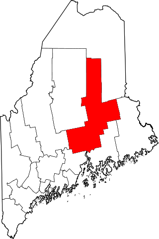
[3] Name on the Register [4] Image Date listed [5] Location City or town Description 1 D.V. Adams Co.-Bussell and Weston D.V. Adams Co.-Bussell and Weston May 2, 1986 (# 86001690 190 Water St. 44°18′59″N 69°46′28″W / 44.316389°N 69.774444°W / 44.316389; -69.774444 (D.V. Adams Co.-Bussell and Weston ) Augusta 2 Alls Souls Church Alls Souls Church January 31, 1978 (# 78000178 70 State St. 44°18′59″N 69°46′38″W / 44.316389°N 69.777222°W / 44.316389; -69.777222 (Alls Souls Church ) Augusta 3 Androscoggin Yacht Club Androscoggin Yacht Club October 31, 2012 (# 12000893 22 Lake St. 44°20′52″N 70°04′08″W / 44.347821°N 70.068916°W / 44.347821; -70.068916 (Androscoggin Yacht Club ) Wayne 4 Arnold Trail to Quebec Arnold Trail to Quebec October 1, 1969 (# 69000018 Along the Kennebec River , through Wayman and Flagstaff lakes along the Dead River and Chain of Ponds to Quebec , Canada 44°40′49″N 69°59′18″W / 44.680278°N 69.988333°W / 44.680278; -69.988333 (Arnold Trail to Quebec ) Augusta Extends through Franklin , Kennebec , Sagadahoc , and Somerset counties 5 Former Augusta City Hall Former Augusta City Hall September 26, 1997 (# 97001134 1 Cony St. 44°19′01″N 69°46′18″W / 44.316944°N 69.771667°W / 44.316944; -69.771667 (Former Augusta City Hall ) Augusta 6 Charles M. Bailey Public Library Charles M. Bailey Public Library June 20, 1985 (# 85001264 Bowdoin St. 44°18′29″N 69°58′24″W / 44.308056°N 69.973333°W / 44.308056; -69.973333 (Charles M. Bailey Public Library ) Winthrop 7 Moses Bailey House Moses Bailey House November 8, 1984 (# 84000325 State Route 135 44°18′20″N 69°55′24″W / 44.305556°N 69.923333°W / 44.305556; -69.923333 (Moses Bailey House ) Winthrop Center 8 Algernon Bangs House Algernon Bangs House February 19, 1982 (# 82000751 16 E. Chestnut St. 44°18′47″N 69°46′02″W / 44.313056°N 69.767222°W / 44.313056; -69.767222 (Algernon Bangs House ) Augusta 9 Benton Grange No. 458 Benton Grange No. 458 April 28, 2004 (# 04000373 Junction of River Rd. and School Dr. 44°35′21″N 69°35′06″W / 44.589167°N 69.585°W / 44.589167; -69.585 (Benton Grange No. 458 ) Benton 10 James G. Blaine House James G. Blaine House October 15, 1966 (# 66000024 Capitol and State Sts. 44°18′28″N 69°46′53″W / 44.307778°N 69.781389°W / 44.307778; -69.781389 (James G. Blaine House ) Augusta 11 Blossom House Blossom House April 7, 1989 (# 89000250 Main St. 44°14′16″N 70°02′12″W / 44.237778°N 70.036667°W / 44.237778; -70.036667 (Blossom House ) Monmouth 12 Bond Street Historic District Bond Street Historic District April 11, 2014 (# 14000137 8, 9, 12, 18, 21, 22 & 25 Bond St., 44°19′14″N 69°46′27″W / 44.3205°N 69.7742°W / 44.3205; -69.7742 (Bond Street Historic District ) Augusta 13 Brick School Brick School April 18, 1977 (# 77000068 South of Winslow on Cushman Rd. 44°30′38″N 69°37′51″W / 44.510556°N 69.630833°W / 44.510556; -69.630833 (Brick School ) Winslow 14 Brown Memorial Library Brown Memorial Library April 28, 1975 (# 75000099 53 Railroad St. 44°38′20″N 69°30′12″W / 44.638799°N 69.503206°W / 44.638799; -69.503206 (Brown Memorial Library ) Clinton John Calvin Stevens , architect (1903). 15 Brunswick Square Brunswick Square June 28, 2021 (# 100006675 Bounded by School St., Brunswick, Dresden, and Lincoln Aves. 44°13′37″N 69°46′31″W / 44.2270°N 69.7752°W / 44.2270; -69.7752 (Brunswick Square ) Gardiner 16 Capitol Complex Historic District Capitol Complex Historic District December 31, 2001 (# 01001417 State and Capitol Sts. 44°18′24″N 69°46′49″W / 44.306667°N 69.780278°W / 44.306667; -69.780278 (Capitol Complex Historic District ) Augusta 17 Capitol Park Capitol Park April 7, 1989 (# 89000252 Roughly bounded by Capitol St., the Kennebec River , Union St., and State St. 44°18′23″N 69°46′43″W / 44.306389°N 69.778611°W / 44.306389; -69.778611 (Capitol Park ) Augusta 18 Chandler Store Chandler Store June 20, 1985 (# 85001263 State Route 27 44°31′41″N 69°53′19″W / 44.528056°N 69.888611°W / 44.528056; -69.888611 (Chandler Store ) Belgrade 19 China Village Historic District China Village Historic District November 23, 1977 (# 77000069 State Route 9 44°28′41″N 69°31′10″W / 44.478056°N 69.519444°W / 44.478056; -69.519444 (China Village Historic District ) China 20 Christ Episcopal Church Christ Episcopal Church July 24, 1973 (# 73000129 1 Dresden Ave. 44°13′39″N 69°46′32″W / 44.2275°N 69.775556°W / 44.2275; -69.775556 (Christ Episcopal Church ) Gardiner 21 Edmund and Rachel Clark Homestead Edmund and Rachel Clark Homestead October 4, 2006 (# 06000921 Address Restricted China 22 Cobbossee Lighthouse Cobbossee Lighthouse January 12, 1984 (# 84001369 Ladies Delight Island 44°18′28″N 69°53′34″W / 44.307778°N 69.892778°W / 44.307778; -69.892778 (Cobbossee Lighthouse ) Winthrop Ladies Delight Light 23 Cobbosseecontee Dam Site Upload image June 3, 1976 (# 76000219 Address Restricted Manchester 24 Colburn House State Historic Site Colburn House State Historic Site July 28, 2004 (# 04000741 Arnold Rd., Old State Route 27 (0.1 miles south of its junction with State Route 27 ) 44°11′52″N 69°45′16″W / 44.197778°N 69.754444°W / 44.197778; -69.754444 (Colburn House State Historic Site ) Pittston 25 Colburn School Colburn School January 11, 2001 (# 00001633 Arnold Rd., 0.4 miles south of its junction with State Route 27 44°11′49″N 69°45′04″W / 44.196944°N 69.751111°W / 44.196944; -69.751111 (Colburn School ) Pittston 26 Colcord Farmstead Colcord Farmstead December 29, 2005 (# 05001468 184 Unity Rd. 44°35′48″N 69°32′22″W / 44.596793°N 69.539402°W / 44.596793; -69.539402 (Colcord Farmstead ) Benton 27 Colonial Theater Colonial Theater October 8, 2014 (# 14000834 139 Water St. 44°19′04″N 69°46′24″W / 44.3178°N 69.7732°W / 44.3178; -69.7732 (Colonial Theater ) Augusta 28 Cony High School Cony High School September 29, 1988 (# 88001841 Cony Circle at Cony and Stone Sts. 44°18′58″N 69°46′03″W / 44.316111°N 69.7675°W / 44.316111; -69.7675 (Cony High School ) Augusta 29 Gov. Samuel Cony House Gov. Samuel Cony House April 11, 1985 (# 85000732 71 Stone St. 44°18′43″N 69°45′50″W / 44.312067°N 69.763798°W / 44.312067; -69.763798 (Gov. Samuel Cony House ) Augusta 30 Crosby Street Historic District Crosby Street Historic District September 11, 1986 (# 86002438 Crosby St. and Crosby Ln. 44°19′05″N 69°46′32″W / 44.318056°N 69.775556°W / 44.318056; -69.775556 (Crosby Street Historic District ) Augusta 31 Cumston Hall Cumston Hall August 14, 1973 (# 73000130 Main St. 44°14′28″N 70°02′04″W / 44.241111°N 70.034444°W / 44.241111; -70.034444 (Cumston Hall ) Monmouth Harry Hayman Cochrane, architect (1899-1900). 32 Cushnoc (ME 021.02) Cushnoc (ME 021.02) October 27, 1989 (# 89001703 Near Fort Western [6] 44°18′55″N 69°46′16″W / 44.315408°N 69.771188°W / 44.315408; -69.771188 (Cushnoc (ME 021.02) ) Augusta Site of a 17th-century Plymouth Colony trading post 33 John Davis House John Davis House July 14, 1983 (# 83000454 State Route 9 44°16′31″N 69°46′21″W / 44.275278°N 69.7725°W / 44.275278; -69.7725 (John Davis House ) Chelsea 34 Doughty Block Doughty Block May 2, 1986 (# 86001691 265 Water St. 44°18′55″N 69°46′28″W / 44.315278°N 69.774444°W / 44.315278; -69.774444 (Doughty Block ) Augusta 35 Dutton-Small House Dutton-Small House December 18, 1990 (# 90001907 Bog Rd. west of Taber Hill Rd. 44°26′22″N 69°39′15″W / 44.439444°N 69.654167°W / 44.439444; -69.654167 (Dutton-Small House ) Vassalboro 36 East Vassalboro Grist and Saw Mill East Vassalboro Grist and Saw Mill January 28, 1982 (# 82000752 State Route 32 44°27′07″N 69°36′24″W / 44.451944°N 69.606667°W / 44.451944; -69.606667 (East Vassalboro Grist and Saw Mill ) East Vassalboro 37 Dr. J.W. Ellis House Dr. J.W. Ellis House August 15, 1979 (# 79000148 62 State St. 44°19′02″N 69°46′38″W / 44.317222°N 69.777222°W / 44.317222; -69.777222 (Dr. J.W. Ellis House ) Augusta 38 Elm Hill Farm Elm Hill Farm August 25, 1970 (# 70000045 Litchfield Rd. 44°16′48″N 69°47′57″W / 44.28°N 69.799167°W / 44.28; -69.799167 (Elm Hill Farm ) Hallowell 39 First Baptist Church First Baptist Church November 7, 1976 (# 76000095 Park and Elm Sts. 44°33′06″N 69°37′59″W / 44.551667°N 69.633056°W / 44.551667; -69.633056 (First Baptist Church ) Waterville 40 Fort Halifax Fort Halifax November 24, 1968 (# 68000015 On U.S. Route 201 at Winslow 44°32′05″N 69°37′47″W / 44.534722°N 69.629722°W / 44.534722; -69.629722 (Fort Halifax ) Winslow 41 Fort Western Fort Western December 2, 1969 (# 69000009 Bowman St. 44°18′59″N 69°46′16″W / 44.316389°N 69.771111°W / 44.316389; -69.771111 (Fort Western ) Augusta 42 Foster Farm Barn Foster Farm Barn November 9, 2015 (# 15000768 538 Augusta Rd. 44°29′28″N 69°51′21″W / 44.4912°N 69.8559°W / 44.4912; -69.8559 (Foster Farm Barn ) Belgrade 43 Foster-Redington House Foster-Redington House April 11, 2014 (# 14000138 8 Park Place 44°33′08″N 69°38′01″W / 44.5522°N 69.6335°W / 44.5522; -69.6335 (Foster-Redington House ) Waterville 44 Fuller-Weston House Fuller-Weston House March 22, 1984 (# 84001374 11 Summer St. 44°18′59″N 69°46′45″W / 44.316389°N 69.779167°W / 44.316389; -69.779167 (Fuller-Weston House ) Augusta 45 Guy P. Gannett House Guy P. Gannett House April 28, 1983 (# 83000455 184 State St. 44°18′32″N 69°46′52″W / 44.308889°N 69.781111°W / 44.308889; -69.781111 (Guy P. Gannett House ) Augusta 46 Gardiner Historic District Gardiner Historic District May 6, 1980 (# 80000233 Water St. 44°13′45″N 69°46′15″W / 44.229167°N 69.770833°W / 44.229167; -69.770833 (Gardiner Historic District ) Gardiner 47 Gardiner Railroad Station Gardiner Railroad Station October 29, 1982 (# 82000423 51 Maine Ave. 44°13′51″N 69°46′18″W / 44.230833°N 69.771667°W / 44.230833; -69.771667 (Gardiner Railroad Station ) Gardiner 48 Governor's House Governor's House February 23, 1974 (# 74000319 Off State Route 17 44°16′48″N 69°42′08″W / 44.280074°N 69.702272°W / 44.280074; -69.702272 (Governor's House ) Togus 49 Peter Grant House Peter Grant House May 17, 1976 (# 76000096 10 Grant St. 44°14′29″N 69°46′27″W / 44.241389°N 69.774167°W / 44.241389; -69.774167 (Peter Grant House ) Farmingdale 50 William F. Grant House William F. Grant House May 17, 2006 (# 06000396 869 Main St. 44°28′57″N 69°37′20″W / 44.4825°N 69.622222°W / 44.4825; -69.622222 (William F. Grant House ) North Vassalboro 51 Hallowell Historic District Hallowell Historic District October 28, 1970 (# 100001675 The hillside of Hallowell 44°17′05″N 69°47′40″W / 44.284722°N 69.794444°W / 44.284722; -69.794444 (Hallowell Historic District ) Hallowell 52 Hartford Fire Station Hartford Fire Station January 2, 2018 (# 100001927 1 Hartford Sq. 44°18′43″N 69°46′32″W / 44.312081°N 69.775555°W / 44.312081; -69.775555 (Hartford Fire Station ) Augusta 53 Heald House Heald House February 15, 2005 (# 05000058 19 West St. 44°33′13″N 69°38′14″W / 44.553611°N 69.637222°W / 44.553611; -69.637222 (Heald House ) Waterville 54 Gov. John F. Hill Mansion Gov. John F. Hill Mansion November 21, 1977 (# 77000070 136 State St. 44°18′45″N 69°46′44″W / 44.3125°N 69.778889°W / 44.3125; -69.778889 (Gov. John F. Hill Mansion ) Augusta 55 Ella R. Hodgkins Intermediate School Ella R. Hodgkins Intermediate School July 14, 2015 (# 15000417 17 Malta St. 44°18′58″N 69°45′26″W / 44.3161°N 69.7571°W / 44.3161; -69.7571 (Ella R. Hodgkins Intermediate School ) Augusta 56 Hussey-Littlefield Farm Hussey-Littlefield Farm January 12, 2016 (# 15000969 63 Hussey Rd. 44°31′45″N 69°26′01″W / 44.5293°N 69.4335°W / 44.5293; -69.4335 (Hussey-Littlefield Farm ) Albion 57 Abel Jones House Abel Jones House August 4, 1983 (# 83000456 Off U.S. Route 202 44°23′53″N 69°34′13″W / 44.398056°N 69.570278°W / 44.398056; -69.570278 (Abel Jones House ) China 58 Eli and Sybil Jones House Eli and Sybil Jones House March 22, 1984 (# 84001376 Dirigo Corner 44°24′33″N 69°31′17″W / 44.409167°N 69.521389°W / 44.409167; -69.521389 (Eli and Sybil Jones House ) South China 59 Journal Building Journal Building May 2, 1986 (# 86001692 325-331 Water St. 44°18′50″N 69°46′30″W / 44.313889°N 69.775°W / 44.313889; -69.775 (Journal Building ) Augusta 60 Kennebec Arsenal Kennebec Arsenal August 25, 1970 (# 70000046 Arsenal St. 44°18′29″N 69°46′10″W / 44.308056°N 69.769444°W / 44.308056; -69.769444 (Kennebec Arsenal ) Augusta 61 Kennebec County Courthouse Kennebec County Courthouse July 25, 1974 (# 74000169 95 State St. 44°18′53″N 69°46′39″W / 44.314722°N 69.7775°W / 44.314722; -69.7775 (Kennebec County Courthouse ) Augusta 62 Kent Burying Ground Kent Burying Ground December 31, 2008 (# 08001254 Northeastern corner of Fayette Corner Rd. and Oak Hill Rd. 44°25′12″N 70°04′17″W / 44.42011°N 70.07149°W / 44.42011; -70.07149 (Kent Burying Ground ) Fayette 63 Kent's Hill School Historic District Kent's Hill School Historic District April 26, 1979 (# 79000149 State Route 17 44°24′06″N 70°00′09″W / 44.401667°N 70.0025°W / 44.401667; -70.0025 (Kent's Hill School Historic District ) Kent's Hill 64 Kresge Building Kresge Building May 2, 1986 (# 86001693 241-249 Water St. 44°18′57″N 69°46′28″W / 44.315833°N 69.774444°W / 44.315833; -69.774444 (Kresge Building ) Augusta 65 Philip Leach House Philip Leach House October 20, 1983 (# 83003644 Hussey Hill Rd. 44°26′54″N 69°36′33″W / 44.448333°N 69.609167°W / 44.448333; -69.609167 (Philip Leach House ) Vassalboro 66 Jesse Lee Church Jesse Lee Church July 19, 1984 (# 84001378 State Route 17 and Plains Rd. 44°21′44″N 69°54′44″W / 44.362222°N 69.912222°W / 44.362222; -69.912222 (Jesse Lee Church ) Readfield 67 Libby-Hill Block Libby-Hill Block May 2, 1986 (# 86001694 227-233 Water St. 44°18′58″N 69°46′27″W / 44.316111°N 69.774167°W / 44.316111; -69.774167 (Libby-Hill Block ) Augusta 68 The Lion (locomotive) The Lion (locomotive) December 15, 1976 (# 76000118 Maine State Museum 44°18′22″N 69°46′57″W / 44.306172°N 69.782444°W / 44.306172; -69.782444 (The Lion (locomotive) ) Augusta Listed at the University of Maine at Machias . 69 Lithgow Library Lithgow Library July 24, 1974 (# 74000170 Winthrop St. 44°18′56″N 69°46′41″W / 44.315556°N 69.778056°W / 44.315556; -69.778056 (Lithgow Library ) Augusta 70 Lockwood Mill Historic District Lockwood Mill Historic District May 8, 2007 (# 07000412 6, 6B, 8, 10, and 10B Water St. 44°32′46″N 69°37′47″W / 44.546111°N 69.629722°W / 44.546111; -69.629722 (Lockwood Mill Historic District ) Waterville 71 Alvin O. Lombard House Alvin O. Lombard House February 19, 1982 (# 82000753 65 Elm St. 44°33′00″N 69°37′59″W / 44.55°N 69.633056°W / 44.55; -69.633056 (Alvin O. Lombard House ) Waterville 72 Jon Lund Site Upload image November 21, 1980 (# 80000234 Address Restricted Manchester 73 Maine Archeological Survey Site 53.36 Upload image December 27, 1990 (# 90001901 Address Restricted Winslow 74 Maine Industrial School for Girls Historic District Maine Industrial School for Girls Historic District April 22, 2003 (# 03000289 Winthrop St., 0.5 miles west of its junction with Water St. 44°17′30″N 69°47′51″W / 44.291667°N 69.7975°W / 44.291667; -69.7975 (Maine Industrial School for Girls Historic District ) Hallowell 75 Maine Insane Hospital Maine Insane Hospital July 19, 1982 (# 82000754 Hospital St.August 2, 2001 : Bounded by Hospital St. and Hospital Ave. 44°18′06″N 69°46′12″W / 44.301667°N 69.77°W / 44.301667; -69.77 (Maine Insane Hospital ) Augusta 76 Maine State House Maine State House April 24, 1973 (# 73000266 Capitol St. 44°18′25″N 69°46′56″W / 44.306944°N 69.782222°W / 44.306944; -69.782222 (Maine State House ) Augusta 77 Masonic Hall Masonic Hall May 2, 1986 (# 86001695 313-321 Water St. 44°18′51″N 69°46′30″W / 44.314167°N 69.775°W / 44.314167; -69.775 (Masonic Hall ) Augusta 78 Memorial Hall Memorial Hall November 23, 1977 (# 77000071 Church St. 44°32′45″N 69°43′12″W / 44.545833°N 69.72°W / 44.545833; -69.72 (Memorial Hall ) Oakland 79 Mill Agent's House Mill Agent's House October 6, 1983 (# 83003645 State Route 32 44°29′10″N 69°37′21″W / 44.486111°N 69.6225°W / 44.486111; -69.6225 (Mill Agent's House ) North Vassalboro 80 Moody Mansion Moody Mansion May 17, 2006 (# 06000394 State Route 194 , across from the junction with Hanley Rd. 44°10′32″N 69°40′24″W / 44.175556°N 69.673333°W / 44.175556; -69.673333 (Moody Mansion ) Pittston 81 Lot Morrill House Lot Morrill House July 18, 1974 (# 74000171 113 Winthrop St. 44°19′01″N 69°47′01″W / 44.316944°N 69.783611°W / 44.316944; -69.783611 (Lot Morrill House ) Augusta 82 Mt. Merici Historic District Mt. Merici Historic District March 28, 2019 (# 100003588 152 Western Ave. & 99 St. Angela Way 44°33′17″N 69°39′21″W / 44.5546°N 69.6558°W / 44.5546; -69.6558 (Mt. Merici Historic District ) Waterville 83 Noble Block Noble Block May 2, 1986 (# 86001696 186 Water St. 44°19′00″N 69°46′27″W / 44.316667°N 69.774167°W / 44.316667; -69.774167 (Noble Block ) Augusta 84 North Monmouth Library North Monmouth Library March 27, 2017 (# 100000807 132 N. Main St. 44°16′33″N 70°01′40″W / 44.275758°N 70.027796°W / 44.275758; -70.027796 (North Monmouth Library ) Monmouth 85 Oakland Public Library Oakland Public Library April 14, 2000 (# 00000375 18 Church St. 44°32′47″N 69°43′11″W / 44.546278°N 69.719686°W / 44.546278; -69.719686 (Oakland Public Library ) Oakland 86 Oaklands Oaklands July 27, 1973 (# 73000131 Southern end of Dresden St. 44°12′48″N 69°45′58″W / 44.213333°N 69.766111°W / 44.213333; -69.766111 (Oaklands ) Gardiner 87 Old Post Office Old Post Office July 18, 1974 (# 74000172 295 Water St. 44°18′52″N 69°46′27″W / 44.314439°N 69.774138°W / 44.314439; -69.774138 (Old Post Office ) Augusta 88 Pendle Hill Pendle Hill August 4, 1983 (# 83000457 Off U.S. Route 202 44°24′37″N 69°33′48″W / 44.410278°N 69.563333°W / 44.410278; -69.563333 (Pendle Hill ) China 89 Pittston Congregational Church Pittston Congregational Church January 31, 1978 (# 78000179 Junction of State Routes 27 and 194 44°13′02″N 69°45′19″W / 44.217222°N 69.755278°W / 44.217222; -69.755278 (Pittston Congregational Church ) Pittston 90 Pond Meeting House Pond Meeting House August 4, 1983 (# 83000458 On U.S. Route 202 44°26′12″N 69°31′41″W / 44.4368°N 69.528°W / 44.4368; -69.528 (Pond Meeting House ) China On the grounds of the Friends Camp 91 Powder House Lot Powder House Lot April 11, 2002 (# 02000348 High St., ¼ mile south of its junction with Winthrop St. 44°17′19″N 69°48′00″W / 44.288611°N 69.8°W / 44.288611; -69.8 (Powder House Lot ) Hallowell 92 Powers House Powers House October 1, 1979 (# 79000150 South of Sidney on State Route 104 44°23′23″N 69°44′07″W / 44.389722°N 69.735259°W / 44.389722; -69.735259 (Powers House ) Sidney 93 Pressey House Pressey House September 15, 1977 (# 77000072 32 Belgrade Rd. 44°32′28″N 69°43′28″W / 44.541134°N 69.724372°W / 44.541134; -69.724372 (Pressey House ) Oakland 94 Professional Building Professional Building February 19, 1982 (# 82000755 177 and 179 Main St. 44°33′07″N 69°37′52″W / 44.551944°N 69.631111°W / 44.551944; -69.631111 (Professional Building ) Waterville 95 Dr. Samuel Quimby House Dr. Samuel Quimby House December 18, 1990 (# 90001903 North Rd. east of its junction with Church Rd. 44°25′49″N 69°56′19″W / 44.430278°N 69.938611°W / 44.430278; -69.938611 (Dr. Samuel Quimby House ) Mount Vernon 96 Readfield Union Meeting House Readfield Union Meeting House July 8, 1982 (# 82000756 Church Rd. 44°23′22″N 69°58′01″W / 44.389444°N 69.966944°W / 44.389444; -69.966944 (Readfield Union Meeting House ) Readfield 97 Redington House Redington House July 21, 1978 (# 78000180 64 Silver St. 44°32′49″N 69°38′05″W / 44.546944°N 69.634722°W / 44.546944; -69.634722 (Redington House ) Waterville Historical society museum 98 G.W. Reed Travellers Home G.W. Reed Travellers Home February 11, 1982 (# 82000757 Address Restricted Benton 99 Laura Richards House Laura Richards House June 14, 1979 (# 79000151 3 Dennis St. 44°13′38″N 69°46′21″W / 44.227222°N 69.7725°W / 44.227222; -69.7725 (Laura Richards House ) Gardiner 100 River Meetinghouse River Meetinghouse September 19, 1977 (# 77000073 U.S. Route 201 and Oak Grove Rd. 44°28′02″N 69°40′30″W / 44.467257°N 69.674923°W / 44.467257; -69.674923 (River Meetinghouse ) Vassalboro 101 Riverview House Riverview House April 12, 2001 (# 01000369 U.S. Route 201 0.15 miles southeast of its junction with Old Federal Rd. 44°22′54″N 69°43′07″W / 44.381667°N 69.718611°W / 44.381667; -69.718611 (Riverview House ) Vassalboro 102 Edwin Arlington Robinson House Edwin Arlington Robinson House November 11, 1971 (# 71000070 67 Lincoln Ave. 44°13′20″N 69°46′25″W / 44.2222°N 69.7736°W / 44.2222; -69.7736 (Edwin Arlington Robinson House ) Gardiner 103 Row House Row House July 1, 1970 (# 70000047 106-114 2nd St. 44°17′14″N 69°47′29″W / 44.287222°N 69.791389°W / 44.287222; -69.791389 (Row House ) Hallowell 104 Elizabeth Ann Seton Hospital Elizabeth Ann Seton Hospital July 11, 2016 (# 16000437 30 Chase Ave. 44°32′57″N 69°39′31″W / 44.549204°N 69.658717°W / 44.549204; -69.658717 (Elizabeth Ann Seton Hospital ) Waterville 105 South China Meeting House South China Meeting House August 4, 1983 (# 83000459 S. China Village 44°23′45″N 69°34′27″W / 44.395833°N 69.574167°W / 44.395833; -69.574167 (South China Meeting House ) South China 106 South Parish Congregational Church and Parish House South Parish Congregational Church and Parish House June 22, 1980 (# 80000235 Church St. 44°19′02″N 69°46′33″W / 44.317222°N 69.775833°W / 44.317222; -69.775833 (South Parish Congregational Church and Parish House ) Augusta 107 Spruce Point Camps Spruce Point Camps February 7, 2007 (# 07000011 84 Bearnstow Rd. 44°29′56″N 70°00′51″W / 44.498889°N 70.014167°W / 44.498889; -70.014167 (Spruce Point Camps ) Mount Vernon Now known as Bearnstow. 108 St. Mark's Episcopal Church St. Mark's Episcopal Church July 19, 1984 (# 84001379 9 Summer St. 44°18′59″N 69°46′43″W / 44.316389°N 69.778611°W / 44.316389; -69.778611 (St. Mark's Episcopal Church ) Augusta 109 St. Mary's Church St. Mary's Church June 12, 1987 (# 87000943 39 Western Ave. 44°18′42″N 69°47′03″W / 44.311667°N 69.784167°W / 44.311667; -69.784167 (St. Mary's Church ) Augusta 110 Starling Grange #156 (former) Starling Grange #156 (former) April 5, 2016 (# 16000136 2769 Main St. (ME 17 ) 44°26′58″N 70°04′07″W / 44.449311°N 70.068494°W / 44.449311; -70.068494 (Starling Grange #156 (former) ) Fayette 111 Capt. Nathaniel Stone House Capt. Nathaniel Stone House April 22, 2003 (# 03000292 268 Maine Ave. 44°14′21″N 69°46′19″W / 44.239167°N 69.771944°W / 44.239167; -69.771944 (Capt. Nathaniel Stone House ) Farmingdale 112 Sturgis and Haskell Building Sturgis and Haskell Building May 2, 1986 (# 86001697 180-182 Water St. 44°19′00″N 69°46′27″W / 44.316667°N 69.774167°W / 44.316667; -69.774167 (Sturgis and Haskell Building ) Augusta 113 Tappan-Viles House Tappan-Viles House February 11, 1982 (# 82000759 154 State St. 44°18′40″N 69°46′48″W / 44.311111°N 69.78°W / 44.311111; -69.78 (Tappan-Viles House ) Augusta 114 The Birches The Birches September 27, 1996 (# 96001036 Off the eastern side of Foster Ln., 0.15 miles south of its junction with State Route 27 44°31′22″N 69°53′14″W / 44.522778°N 69.887222°W / 44.522778; -69.887222 (The Birches ) Belgrade Lakes 115 Tiffany Chapel Tiffany Chapel October 4, 2018 (# 100003010 544 Tiffany Rd. 44°27′42″N 69°45′22″W / 44.4617°N 69.7560°W / 44.4617; -69.7560 (Tiffany Chapel ) Sidney 116 Togus VA Medical Center and National Cemetery Togus VA Medical Center and National Cemetery October 3, 2012 (# 12000826 1 VA Center 44°16′43″N 69°42′15″W / 44.278638°N 69.704132°W / 44.278638; -69.704132 (Togus VA Medical Center and National Cemetery ) Togus 117 Two Cent Bridge Two Cent Bridge September 20, 1973 (# 73000132 Spans the Kennebec River at Temple St. 44°33′03″N 69°37′45″W / 44.550833°N 69.629167°W / 44.550833; -69.629167 (Two Cent Bridge ) Waterville and Winslow 118 Joseph H. Underwood House Joseph H. Underwood House December 28, 2005 (# 05001470 1957 Main St. 44°24′33″N 70°02′02″W / 44.409167°N 70.033889°W / 44.409167; -70.033889 (Joseph H. Underwood House ) Fayette 119 Universalist-Unitarian Church Universalist-Unitarian Church February 17, 1978 (# 78000181 Silver and Elm Sts. 44°32′48″N 69°38′09″W / 44.546667°N 69.635833°W / 44.546667; -69.635833 (Universalist-Unitarian Church ) Waterville 120 Vassalboro Mill Vassalboro Mill October 5, 2020 (# 100005649 934 and 960 Main St. 44°29′12″N 69°37′23″W / 44.4866°N 69.6231°W / 44.4866; -69.6231 (Vassalboro Mill ) Vassalboro 121 Vaughan Homestead Vaughan Homestead October 6, 1970 (# 70000091 Middle St. off Litchfield Rd. 44°16′36″N 69°47′43″W / 44.2767°N 69.7953°W / 44.2767; -69.7953 (Vaughan Homestead ) Hallowell 122 Vickery Building Vickery Building March 22, 1984 (# 84001380 261 Water St. 44°18′46″N 69°46′28″W / 44.3128°N 69.7744°W / 44.3128; -69.7744 (Vickery Building ) Augusta 123 Vienna Town House Vienna Town House October 29, 1982 (# 82000424 State Route 41 44°32′21″N 69°59′57″W / 44.5392°N 69.9992°W / 44.5392; -69.9992 (Vienna Town House ) Vienna 124 Water Street Water Street January 17, 2017 (# 100000524 71-286 Water & 1 Winthrop Sts. 44°18′56″N 69°46′26″W / 44.3156°N 69.7740°W / 44.3156; -69.7740 (Water Street ) Augusta 125 Waterville High School Waterville High School September 30, 2010 (# 10000807 21 Gilman St. 44°33′13″N 69°38′14″W / 44.5536°N 69.6372°W / 44.5536; -69.6372 (Waterville High School ) Waterville aka the Gilman Street School, now apartments. 126 Waterville Main Street Historic District Waterville Main Street Historic District December 19, 2012 (# 12001066 Roughly Main & Common Sts.; also 129-179 Main & 13 Appleton Sts. 44°32′58″N 69°37′47″W / 44.5495°N 69.6298°W / 44.5495; -69.6298 (Waterville Main Street Historic District ) Waterville Second set of addresses represent a boundary increase September 27, 2016 127 Waterville Opera House and City Hall Waterville Opera House and City Hall January 1, 1976 (# 76000097 Castonguay Sq. 44°32′59″N 69°37′47″W / 44.5497°N 69.6297°W / 44.5497; -69.6297 (Waterville Opera House and City Hall ) Waterville 128 Waterville Post Office Waterville Post Office April 18, 1977 (# 77000074 Main and Elm St. 44°33′08″N 69°37′54″W / 44.5522°N 69.6317°W / 44.5522; -69.6317 (Waterville Post Office ) Waterville 129 Wayne Town House Wayne Town House January 1, 1976 (# 76000098 State Route 133 44°21′10″N 70°04′25″W / 44.3528°N 70.0736°W / 44.3528; -70.0736 (Wayne Town House ) Wayne 130 Whitehouse Block Whitehouse Block May 2, 1986 (# 86001698 188 Water St. 44°19′00″N 69°46′27″W / 44.3167°N 69.7742°W / 44.3167; -69.7742 (Whitehouse Block ) Augusta 131 Williams Block Williams Block May 2, 1986 (# 86001699 183-187 Water St. 44°19′00″N 69°46′28″W / 44.3167°N 69.7744°W / 44.3167; -69.7744 (Williams Block ) Augusta 132 John Williams House John Williams House December 6, 1984 (# 84000531 Church St. 44°30′07″N 69°59′19″W / 44.5019°N 69.9886°W / 44.5019; -69.9886 (John Williams House ) Mount Vernon 133 Wing Family Cemetery Wing Family Cemetery October 16, 1991 (# 91001514 Eastern side of Pond Rd. north of its junction with State Route 133 44°22′14″N 70°04′01″W / 44.3706°N 70.0669°W / 44.3706; -70.0669 (Wing Family Cemetery ) Wayne 134 Winthrop Mills Company Winthrop Mills Company October 8, 2014 (# 14000835 149-151 Main Street 44°18′26″N 69°58′17″W / 44.3072°N 69.9714°W / 44.3072; -69.9714 (Winthrop Mills Company ) Winthrop 135 Winthrop Street Historic District Winthrop Street Historic District August 6, 2001 (# 01000815 Roughly bounded by State, Bridge, North and South Chestnut, and Green Sts.December 30, 2008 , refnum 08001255): 20 Spring St. 44°18′54″N 69°46′52″W / 44.315°N 69.7811°W / 44.315; -69.7811 (Winthrop Street Historic District ) Augusta