National Register of Historic Places listings in King William County, Virginia

Last updated

Location of King William County in Virginia Map of Virginia highlighting King William County.svg
Location of King William County in Virginia

This is a list of the National Register of Historic Places listings in King William County, Virginia.

Contents

This is intended to be a complete list of the properties and districts on the National Register of Historic Places in King William County, Virginia, United States. The locations of National Register properties and districts for which the latitude and longitude coordinates are included below, may be seen in an online map. [1]

The county has 21 properties and districts listed on the National Register, including 1 National Historic Landmark.


    This National Park Service list is complete through NPS recent listings posted September 8, 2023. [2]

Map all coordinates using: OpenStreetMap

Current listings

[3] Name on the Register [4] ImageDate listed [5] Location City or townDescription
1 Burlington
Burlington Burlington estate entrance.jpg
Burlington
January 30, 1978
(#78003023)
River Rd. southeast of Beulahville [6]
37°50′40″N77°08′38″W / 37.844444°N 77.143889°W / 37.844444; -77.143889 (Burlington)
Aylett
2 Chelsea
Chelsea Front Elevation (Chelsea plantation).jpg
Chelsea
November 12, 1969
(#69000253)
North of the junction of State Route 30 and Chelsea Rd.
37°35′55″N76°49′38″W / 37.598611°N 76.827222°W / 37.598611; -76.827222 (Chelsea)
West Point
3 Chericoke
Chericoke Chericoke plantation entrance.jpg
Chericoke
September 8, 1980
(#80004195)
West of Falls on Chericoke Rd.
37°38′09″N77°06′45″W / 37.635833°N 77.112500°W / 37.635833; -77.112500 (Chericoke)
Falls
4 Cherry Grove September 5, 2023
(#100009312)
4381 Manfield Rd.
37°44′00″N77°12′39″W / 37.7333°N 77.2107°W / 37.7333; -77.2107 (Cherry Grove)
Aylett vicinity
5 Elsing Green
Elsing Green Elsinggreen.jpg
Elsing Green
November 12, 1969
(#69000252)
Southwest of the junction of Union Hope and Mount Olive Cohoke Rds.
37°36′08″N77°03′04″W / 37.602222°N 77.051111°W / 37.602222; -77.051111 (Elsing Green)
Tunstall
6 Horn Quarter
Horn Quarter HORN QUARTER.jpg
Horn Quarter
June 9, 1980
(#80004196)
Northwest of Manquin on Etna Mills Rd.
37°46′34″N77°18′42″W / 37.776111°N 77.311667°W / 37.776111; -77.311667 (Horn Quarter)
Manquin
7 King William County Courthouse
King William County Courthouse DSC 0102 01.JPG
King William County Courthouse
October 1, 1969
(#69000251)
Horse Landing Rd., off State Route 30
37°41′16″N77°00′48″W / 37.687778°N 77.013333°W / 37.687778; -77.013333 (King William County Courthouse)
King William
8 King William Training School
King William Training School King William Training School 1.JPG
King William Training School
September 19, 2006
(#06000872)
18627 State Route 30
37°41′44″N77°01′58″W / 37.695556°N 77.032778°W / 37.695556; -77.032778 (King William Training School)
King William
9 Lanesville Christadelphian Church
Lanesville Christadelphian Church Lanesville Christadelphian church.jpg
Lanesville Christadelphian Church
January 14, 2019
(#100003314)
7442 Mount Olive Cohoke Rd.
37°36′52″N76°58′43″W / 37.614444°N 76.978611°W / 37.614444; -76.978611 (Lanesville Christadelphian Church)
King William
10 Mangohick Church
Mangohick Church King William Courthouse and Vicinity - 19.jpg
Mangohick Church
December 5, 1972
(#72001402)
Mangohick Church Rd., south of State Route 30
37°48′28″N77°16′18″W / 37.807778°N 77.271667°W / 37.807778; -77.271667 (Mangohick Church)
Mangohick
11 Mount Columbia
Mount Columbia Mount Columbia entrance.jpg
Mount Columbia
January 19, 1989
(#88003208)
Off Brandywine Rd., 2.7 miles (4.3 km) west of Manfield Rd.
37°42′49″N77°11′11″W / 37.713611°N 77.186389°W / 37.713611; -77.186389 (Mount Columbia)
Manquin
12 Pamunkey Indian Reservation Archaeological District
Pamunkey Indian Reservation Archaeological District Pamunkey Indian Reservation cabin.jpg
Pamunkey Indian Reservation Archaeological District
September 16, 1982
(#82004567)
Entirety of the Pamunkey Indian Reservation [7]
37°34′32″N77°00′14″W / 37.575556°N 77.003889°W / 37.575556; -77.003889 (Pamunkey Indian Reservation Archaeological District)
Lanesville
13 Roseville Plantation
Roseville Plantation Roseville, State Route 604 vicinity, Mangohick vicinity (King William County, Virginia).jpg
Roseville Plantation
August 8, 2007
(#07000800)
3736 Herring Creek Rd.
37°51′09″N77°15′30″W / 37.852500°N 77.258333°W / 37.852500; -77.258333 (Roseville Plantation)
Aylett
14 St. John's Church
St. John's Church Old St. John's Church, State Route 30 vicinity, West Point vicinity (King William County, Virginia).jpg
St. John's Church
April 24, 1973
(#73002214)
Northwest of Sweet Hall on State Route 30
37°36′59″N76°55′16″W / 37.616389°N 76.921111°W / 37.616389; -76.921111 (St. John's Church)
Sweet Hall
15 Seven Springs
Seven Springs SevenSpringsEastElevation.jpg
Seven Springs
May 6, 1980
(#80004194)
West of Enfield
37°44′47″N77°13′54″W / 37.746389°N 77.231667°W / 37.746389; -77.231667 (Seven Springs)
Enfield
16 Sharon Indian School
Sharon Indian School Sharon Indian School 3.JPG
Sharon Indian School
July 27, 2007
(#07000764)
13383 State Route 30
37°44′04″N77°06′50″W / 37.734444°N 77.113889°W / 37.734444; -77.113889 (Sharon Indian School)
King William
17 Sweet Hall
Sweet Hall SWEET HALL.jpg
Sweet Hall
November 7, 1977
(#77001490)
South of Sweet Hall Road (State Route 634)
37°34′11″N76°54′16″W / 37.569811°N 76.904444°W / 37.569811; -76.904444 (Sweet Hall)
Sweet Hall
18 West Point Historic District
West Point Historic District Post office, West Point, Virginia.jpg
West Point Historic District
October 3, 1996
(#96001051)
Kirby, Main, and Lee Sts. from 1st through 13th Sts.
37°32′00″N76°47′51″W / 37.533333°N 76.797500°W / 37.533333; -76.797500 (West Point Historic District)
West Point
19 Windsor Shades
Windsor Shades Windsorshades.jpg
Windsor Shades
May 22, 1978
(#78003025)
South of Sweet Hall Road (State Route 634)
37°34′15″N76°54′38″W / 37.570833°N 76.910556°W / 37.570833; -76.910556 (Windsor Shades)
Sweet Hall
20 Wyoming
Wyoming Wyoming, King William County.jpg
Wyoming
February 8, 1980
(#80004197)
North of Studley on Nelsons Bridge Rd.
37°43′24″N77°17′10″W / 37.723333°N 77.286111°W / 37.723333; -77.286111 (Wyoming)
Studley
21 Zoar
Zoar Zoar near Aylett.jpg
Zoar
June 22, 2007
(#06000065)
Upshaw Rd.
37°47′19″N77°06′38″W / 37.788611°N 77.110556°W / 37.788611; -77.110556 (Zoar)
Aylett

See also

Related Research Articles

<span class="mw-page-title-main">National Register of Historic Places listings in Fairfax County, Virginia</span>

This is a list of the National Register of Historic Places listings in Fairfax County, Virginia.

<span class="mw-page-title-main">National Register of Historic Places listings in Amherst County, Virginia</span>

This is a list of the National Register of Historic Places listings in Amherst County, Virginia.

<span class="mw-page-title-main">National Register of Historic Places listings in Arlington County, Virginia</span>

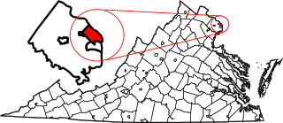
This is a list of the National Register of Historic Places listings in Arlington County, Virginia.

<span class="mw-page-title-main">National Register of Historic Places listings in Bath County, Virginia</span>

This is a list of the National Register of Historic Places listings in Bath County, Virginia.

<span class="mw-page-title-main">National Register of Historic Places listings in Caroline County, Virginia</span>

This is a list of the National Register of Historic Places listings in Caroline County, Virginia.

<span class="mw-page-title-main">National Register of Historic Places listings in Charles City County, Virginia</span>

This is a list of the National Register of Historic Places listings in Charles City County, Virginia.

<span class="mw-page-title-main">National Register of Historic Places listings in Chesterfield County, Virginia</span>

This is a list of the National Register of Historic Places listings in Chesterfield County, Virginia.

<span class="mw-page-title-main">National Register of Historic Places listings in Pittsylvania County, Virginia</span>

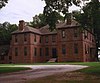
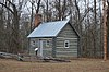
This is a list of the National Register of Historic Places listings in Pittsylvania County, Virginia.

<span class="mw-page-title-main">National Register of Historic Places listings in Kanawha County, West Virginia</span>

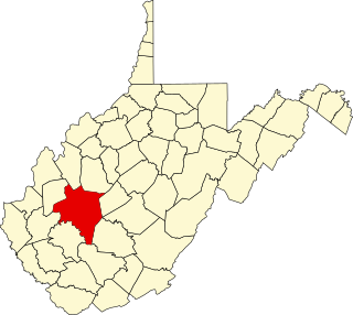
This is a list of the National Register of Historic Places listings in Kanawha County, West Virginia.

<span class="mw-page-title-main">National Register of Historic Places listings in Stafford County, Virginia</span>

This is a list of the National Register of Historic Places listings in Stafford County, Virginia.

<span class="mw-page-title-main">National Register of Historic Places listings in Gloucester County, Virginia</span>

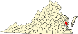
This is a list of the National Register of Historic Places listings in Gloucester County, Virginia.

<span class="mw-page-title-main">National Register of Historic Places listings in Loudoun County, Virginia</span>

This is a list of the National Register of Historic Places listings in Loudoun County, Virginia.

<span class="mw-page-title-main">National Register of Historic Places listings in Prince William County, Virginia</span>

This is a list of the National Register of Historic Places listings in Prince William County, Virginia.

<span class="mw-page-title-main">National Register of Historic Places listings in Pulaski County, Virginia</span>

This is a list of the National Register of Historic Places listings in Pulaski County, Virginia.

<span class="mw-page-title-main">National Register of Historic Places listings in York County, Virginia</span>

This is a list of the National Register of Historic Places listings in York County, Virginia.

<span class="mw-page-title-main">National Register of Historic Places listings in Northampton County, Virginia</span>

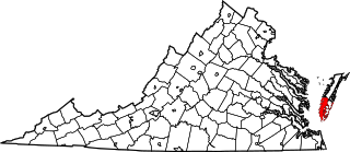
This is a list of the National Register of Historic Places listings in Northampton County, Virginia.

<span class="mw-page-title-main">National Register of Historic Places listings in Surry County, Virginia</span>

This is a list of the National Register of Historic Places listings in Surry County, Virginia.

<span class="mw-page-title-main">National Register of Historic Places listings in Appomattox County, Virginia</span>

This is a list of the National Register of Historic Places listings in Appomattox County, Virginia.

<span class="mw-page-title-main">National Register of Historic Places listings in Highland County, Virginia</span>

This is a list of the National Register of Historic Places listings in Highland County, Virginia.

<span class="mw-page-title-main">National Register of Historic Places listings in Manassas Park, Virginia</span>

This is a list of the National Register of Historic Places listings in Manassas Park, Virginia.

References

  1. The latitude and longitude information provided in this table was derived originally from the National Register Information System, which has been found to be fairly accurate for about 99% of listings. Some locations in this table may have been corrected to current GPS standards.
  2. National Park Service, United States Department of the Interior, "National Register of Historic Places: Weekly List Actions", retrieved September 8, 2023.
  3. Numbers represent an alphabetical ordering by significant words. Various colorings, defined here, differentiate National Historic Landmarks and historic districts from other NRHP buildings, structures, sites or objects.
  4. "National Register Information System". National Register of Historic Places . National Park Service. April 24, 2008.
  5. The eight-digit number below each date is the number assigned to each location in the National Register Information System database, which can be viewed by clicking the number.
  6. Virginia Historic Landmarks Commission Staff. National Register of Historic Places Inventory/Nomination: Burlington. National Park Service, 1977-03, 7.
  7. McCartney, Martha, and Mary Ellen Norrisey Hodges. National Register of Historic Places Inventory/Nomination: Pamunkey Indian Reservation Archaeological District. National Park Service, 1980-10-01, 24.