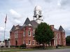
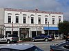
This is a list of properties and districts in Macon County, Georgia that are listed on the National Register of Historic Places (NRHP).
- This National Park Service list is complete through NPS recent listings posted September 25, 2020. [1]
This is a list of properties and districts in Macon County, Georgia that are listed on the National Register of Historic Places (NRHP).
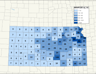
There are over 1,400 buildings, sites, districts, and objects in Kansas listed on the National Register of Historic Places in Kansas. NRHP listings appear in 101 of the state's 105 counties.

This is a list of the buildings, sites, districts, and objects listed on the National Register of Historic Places in the Republic of Palau. There are currently six listed sites located in only four of the sixteen states of Palau.

This is a list of the National Register of Historic Places (NRHP) designated in Worcester County, Massachusetts. The locations of NRHP properties and districts for which the latitude and longitude coordinates are included below, may be seen in a map.
This is a list of the National Register of Historic Places listings in Strafford County, New Hampshire.

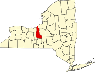
This is intended to be a complete list of properties and districts listed on the National Register of Historic Places in Allegany County, New York. The locations of National Register properties and districts for which the latitude and longitude coordinates are included below, may be seen in a map.

This is intended to be a complete list of properties and districts listed on the National Register of Historic Places in Cattaraugus County, New York. The locations of National Register properties and districts for which the latitude and longitude coordinates are included below, may be seen in a map.
The following is a list of the National Register of Historic Places listings located in Cayuga County, New York:

This is a list of the National Register of Historic Places listings in Lycoming County, Pennsylvania.
These are the National Register of Historic Places listings in Arlington, Massachusetts.
This is a list of places on the National Register of Historic Places in Concord, Massachusetts.

This is a list of the National Register of Historic Places listings in Riverside County, California.

This is a list of the National Register of Historic Places listings in Centre County, Pennsylvania.
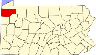
This is a list of the National Register of Historic Places listings in Crawford County, Pennsylvania.

This is a list of the National Register of Historic Places listings in Clinton County, Pennsylvania.

This is a list of the National Register of Historic Places listings in Juniata County, Pennsylvania.

This is a list of the National Register of Historic Places listings in Pike County, Pennsylvania.

This is a list of the National Register of Historic Places listings in Spartanburg County, South Carolina.
This is a list of the National Register of Historic Places listings in Cuyahoga Valley National Park.

Barnstable, Massachusetts, has more than 75 entries on the National Register of Historic Places. For listings elsewhere in Barnstable County, see National Register of Historic Places listings in Barnstable County, Massachusetts.
This is a list of the National Register of Historic Places (NRHP) designated in northern Worcester County, Massachusetts. It includes listings from all Worcester County communities through which Massachusetts Route 2 passes, and those that lie to their north. This includes the communities of Ashburnham, Ashby, Athol, Fitchburg, Gardner, Harvard, Lancaster, Leominster, Lunenburg, Phillipston, Royalston, Templeton, Westminster, and Winchendon. National Register listings for other communities in the county are listed elsewhere.
| Wikimedia Commons has media related to National Register of Historic Places in Macon County, Georgia . |
| Topics | |
|---|---|
| Lists by state |
|
| Lists by insular areas | |
| Lists by associated state | |
| Other areas | |
| Related | |