National Register of Historic Places listings in Martin County, Florida

Last updated
Location of Martin County in Florida Map of Florida highlighting Martin County.svg
Location of Martin County in Florida

This is a list of the National Register of Historic Places listings in Martin County, Florida.

Contents

This is intended to be a complete list of the properties and districts on the National Register of Historic Places in Martin County, Florida, United States. The locations of National Register properties and districts for which the latitude and longitude coordinates are included below, may be seen in a map. [1]

National Register of Historic Places federal list of historic sites in the United States

The National Register of Historic Places (NRHP) is the United States federal government's official list of districts, sites, buildings, structures, and objects deemed worthy of preservation for their historical significance. A property listed in the National Register, or located within a National Register Historic District, may qualify for tax incentives derived from the total value of expenses incurred preserving the property.

Martin County, Florida County in Florida, United States

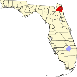
Martin County is a county located in the Treasure Coast region of the state of Florida, in the United States. As of the 2010 census, the population was 146,318. Its county seat is Stuart.

Florida State of the United States of America

Florida is the southernmost contiguous state in the United States. The state is bordered to the west by the Gulf of Mexico, to the northwest by Alabama, to the north by Georgia, to the east by the Atlantic Ocean, and to the south by the Straits of Florida. Florida is the 22nd-most extensive, the 3rd-most populous, and the 8th-most densely populated of the U.S. states. Jacksonville is the most populous municipality in the state and the largest city by area in the contiguous United States. The Miami metropolitan area is Florida's most populous urban area. Tallahassee is the state's capital.

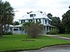
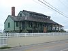
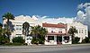
There are 14 properties and districts listed on the National Register in the county.

This National Park Service list is complete through NPS recent listings posted October 29, 2018. [2]
Map all coordinates using: OpenStreetMap  
Download coordinates as: KML  ·  GPX

Current listings

[3] Name on the Register [4] ImageDate listed [5] Location City or townDescription
1 Burn Brae Plantation-Krueger House
Burn Brae Plantation-Krueger House Stuart FL Burn Brae House01.jpg
Burn Brae Plantation-Krueger House
February 14, 2002
(#02000002)
1170 Southeast Ocean Boulevard
27°11′47″N80°13′56″W / 27.196389°N 80.232222°W / 27.196389; -80.232222 (Burn Brae Plantation-Krueger House)
Stuart NRHP# 02000002
2 Cypress Lodge
Cypress Lodge Port Mayaca FL Cypress Lodge01.jpg
Cypress Lodge
November 12, 2008
(#08001040)
18681 SW Conners Highway
26°58′29″N80°36′48″W / 26.974731°N 80.613231°W / 26.974731; -80.613231 (Cypress Lodge)
Port Mayaca NRHP# 08001040
3 Gate House
Gate House Jupiter Island FL Gate House addr01.jpg
Gate House
November 21, 2001
(#01001246)
214 South Beach Road
27°02′09″N80°06′16″W / 27.035833°N 80.104444°W / 27.035833; -80.104444 (Gate House)
Jupiter Island NRHP# 01001246
4 Georges Valentine Shipwreck Site
Georges Valentine Shipwreck Site Hutchinson Island FL Georges Valentine wreck plaque02.jpg
Georges Valentine Shipwreck Site
July 19, 2006
(#06000619)
Offshore of the House of Refuge
27°11′55″N80°09′47″W / 27.198611°N 80.163056°W / 27.198611; -80.163056 (Georges Valentine Shipwreck Site)
Hutchinson Island NRHP# 06000619
5 Golden Gate Building
Golden Gate Building Stuart FL Golden Gate Bldg01.jpg
Golden Gate Building
October 12, 2017
(#100001736)
3225 SE. Dixie Hwy.
27°09′55″N80°13′09″W / 27.165382°N 80.219163°W / 27.165382; -80.219163 (Golden Gate Building)
Stuart NRHP# 06000619
6 House of Refuge at Gilbert's Bar
House of Refuge at Gilbert's Bar Hutchinson Island FL Gilberts HoR01.jpg
House of Refuge at Gilbert's Bar
May 3, 1974
(#74000651)
301 Southeast MacArthur Boulevard, south of Indian River Plantation and north of Bathtub Beach
27°11′57″N80°09′56″W / 27.199167°N 80.165556°W / 27.199167; -80.165556 (House of Refuge at Gilbert's Bar)
Hutchinson Island NRHP# 74000651
7 Lyric Theatre
Lyric Theatre Lyric Theatre, Stuart, Florida 003.JPG
Lyric Theatre
November 12, 1993
(#93001204)
59 Southwest Flagler Avenue
27°11′56″N80°15′17″W / 27.198889°N 80.254722°W / 27.198889; -80.254722 (Lyric Theatre)
Stuart NRHP# 93001204
8 Mount Elizabeth Archeological Site
Mount Elizabeth Archeological Site Leach Mansion frtview.jpg
Mount Elizabeth Archeological Site
September 14, 2002
(#02001011)
1707 Northeast Indian River Drive
27°13′40″N80°12′48″W / 27.227778°N 80.213333°W / 27.227778; -80.213333 (Mount Elizabeth Archeological Site)
Jensen Beach NRHP# 02001011
9 Old Martin County Courthouse
Old Martin County Courthouse OldMartinCountyFlaCourthouse 012.JPG
Old Martin County Courthouse
November 7, 1997
(#97001329)
80 East Ocean Boulevard
27°12′02″N80°14′44″W / 27.200556°N 80.245556°W / 27.200556; -80.245556 (Old Martin County Courthouse)
Stuart NRHP# 97001329
10 Olympia School
Olympia School Hobe Sound FL Olympia School01.jpg
Olympia School
December 20, 2002
(#02001534)
9141 Southeast Apollo St.
27°03′34″N80°07′53″W / 27.059444°N 80.131389°W / 27.059444; -80.131389 (Olympia School)
Hobe Sound NRHP# 02001534
11 Seminole Inn
Seminole Inn SeminoleInn.jpg
Seminole Inn
May 31, 2006
(#06000442)
15885 Southwest Warfield Boulevard
27°01′27″N80°28′10″W / 27.024167°N 80.469444°W / 27.024167; -80.469444 (Seminole Inn)
Indiantown NRHP# 06000442
12 Stuart Welcome Arch
Stuart Welcome Arch Stuart Welcome Arch 007.JPG
Stuart Welcome Arch
September 15, 2004
(#04000971)
Between 2369 and 2390 Northeast Dixie Highway
27°13′31″N80°13′13″W / 27.225278°N 80.220278°W / 27.225278; -80.220278 (Stuart Welcome Arch)
Jensen Beach NRHP# 04000971
13 Trapper Nelson Zoo Historic District
Trapper Nelson Zoo Historic District Hobe Sound FL Jonathan Dickinson SP Trapper John artif03.jpg
Trapper Nelson Zoo Historic District
October 3, 2006
(#06000918)
16450 Southeast Federal Highway
26°58′37″N80°09′49″W / 26.976944°N 80.163611°W / 26.976944; -80.163611 (Trapper Nelson Zoo Historic District)
Hobe Sound NRHP# 06000918
14 Tuckahoe
Tuckahoe Leach Mansion frtview.jpg
Tuckahoe
November 30, 2005
(#05001339)
1921 Northeast Indian River Drive
27°13′41″N80°12′48″W / 27.228056°N 80.213333°W / 27.228056; -80.213333 (Tuckahoe)
Jensen Beach NRHP# 05001339

See also

National Register of Historic Places listings in Florida Wikimedia list article


There are more than 1,700 properties and districts listed on the National Register of Historic Places in Florida. They are distributed through 66 of the state's 67 counties. Of these, 42 are National Historic Landmarks.

Related Research Articles

National Register of Historic Places listings in Westchester County, New York Wikimedia list article

This is a list of the National Register of Historic Places listings in Westchester County, New York.

National Register of Historic Places listings in Miami-Dade County, Florida Wikimedia list article

This is a list of the National Register of Historic Places listings in Miami-Dade County, Florida.

National Register of Historic Places listings in Somerville, Massachusetts Wikimedia list article

This is a list of properties and historic districts in Somerville, Massachusetts, that have been listed on the National Register of Historic Places.

National Register of Historic Places listings in Duval County, Florida Wikimedia list article

This is a list of the National Register of Historic Places listings in Duval County, Florida.

National Register of Historic Places listings in Escambia County, Florida Wikimedia list article

This is a list of the National Register of Historic Places listings in Escambia County, Florida.

National Register of Historic Places listings in Prince Georges County, Maryland Wikimedia list article

This is a list of the National Register of Historic Places listings in Prince George's County, Maryland.

National Register of Historic Places listings in Wakulla County, Florida Wikimedia list article

This is a list of the National Register of Historic Places listings in Wakulla County, Florida.

National Register of Historic Places listings in Marion County, Ohio Wikimedia list article

This is a list of the National Register of Historic Places listings in Marion County, Ohio.

National Register of Historic Places listings in Hocking County, Ohio Wikimedia list article

This is a list of the National Register of Historic Places listings in Hocking County, Ohio.

National Register of Historic Places listings in Lafayette County, Missouri Wikimedia list article

This is a list of the National Register of Historic Places listings in Lafayette County, Missouri.

National Register of Historic Places listings in Pettis County, Missouri Wikimedia list article

This is a list of the National Register of Historic Places listings in Pettis County, Missouri.

National Register of Historic Places listings in Macon County, Missouri Wikimedia list article

This is a list of the National Register of Historic Places listings in Macon County, Missouri.

National Register of Historic Places listings in Iron County, Missouri Wikimedia list article

This is a list of the National Register of Historic Places listings in Iron County, Missouri.

National Register of Historic Places listings in Carroll County, Missouri Wikimedia list article

This is a list of the National Register of Historic Places listings in Carroll County, Missouri.

National Register of Historic Places listings in Madison County, Missouri Wikimedia list article

This is a list of the National Register of Historic Places listings in Madison County, Missouri.

National Register of Historic Places listings in Camden County, Missouri Wikimedia list article

This is a list of the National Register of Historic Places listings in Camden County, Missouri.

National Register of Historic Places listings in Newton County, Missouri Wikimedia list article

This is a list of the National Register of Historic Places listings in Newton County, Missouri.

National Register of Historic Places listings in Cass County, Missouri Wikimedia list article

This is a list of the National Register of Historic Places listings in Cass County, Missouri.

National Register of Historic Places listings in Howell County, Missouri Wikimedia list article

This is a list of the National Register of Historic Places listings in Howell County, Missouri.

National Register of Historic Places listings in Sullivan County, Missouri Wikimedia list article

This is a list of the National Register of Historic Places listings in Sullivan County, Missouri.

References

  1. The latitude and longitude information provided in this table was derived originally from the National Register Information System, which has been found to be fairly accurate for about 99% of listings. For about 1% of NRIS original coordinates, experience has shown that one or both coordinates are typos or otherwise extremely far off; some corrections may have been made. A more subtle problem causes many locations to be off by up to 150 yards, depending on location in the country: most NRIS coordinates were derived from tracing out latitude and longitudes from USGS topographical quadrant maps created under the North American Datum of 1927 , which differs from the current, highly accurate WGS84 GPS system used by most on-line maps. Chicago is about right, but NRIS longitudes in Washington are higher by about 4.5 seconds, and are lower by about 2.0 seconds in Maine. Latitudes differ by about 1.0 second in Florida. Some locations in this table may have been corrected to current GPS standards.
  2. "National Register of Historic Places: Weekly List Actions". National Park Service, United States Department of the Interior. Retrieved on October 29, 2018.
  3. Numbers represent an ordering by significant words. Various colorings, defined here, differentiate National Historic Landmarks and historic districts from other NRHP buildings, structures, sites or objects.
  4. National Park Service (2009-03-13). "National Register Information System". National Register of Historic Places . National Park Service.
  5. The eight-digit number below each date is the number assigned to each location in the National Register Information System database, which can be viewed by clicking the number.