National Register of Historic Places listings in Nevada County, California

Last updated
Location of Nevada County in California Map of California highlighting Nevada County.svg
Location of Nevada County in California

This is a list of the National Register of Historic Places listings in Nevada County, California.

Contents

This is intended to be a complete list of the properties and districts on the National Register of Historic Places in Nevada County, California, United States. Latitude and longitude coordinates are provided for many National Register properties and districts; these locations may be seen together in an online map. [1]

There are 24 properties and districts listed on the National Register in the county, including 1 National Historic Landmark.

This National Park Service list is complete through NPS recent listings posted July 16, 2021. [2]
Map all coordinates using: OpenStreetMap  
Download coordinates as: KML

Current listings

[3] Name on the Register [4] ImageDate listed [5] Location City or townDescription
1 Boca Dam
Boca Dam Boca Dam.jpg
Boca Dam
March 25, 1981
(#81000712)
S end of Boca Reservoir
39°23′26″N120°05′36″W / 39.390556°N 120.093333°W / 39.390556; -120.093333 (Boca Dam)
Truckee
2 Bridgeport Covered Bridge
Bridgeport Covered Bridge Bridgeport Covered Bridge2.jpg
Bridgeport Covered Bridge
July 14, 1971
(#71000168)
SW of French Corral over S. Yuba River
39°17′01″N121°11′40″W / 39.283611°N 121.194444°W / 39.283611; -121.194444 (Bridgeport Covered Bridge)
French Corral
3 Commercial Row-Brickelltown Historic District
Commercial Row-Brickelltown Historic District Commercial Row-Brickelltown Historic District 2012-09-15 17-48-19.jpg
Commercial Row-Brickelltown Historic District
October 8, 2009
(#09000803)
Roughly the north side of Donner Pass Rd. from Bridge St. westwards approx. 1,700 ft.
39°19′39″N120°11′12″W / 39.327444°N 120.186758°W / 39.327444; -120.186758 (Commercial Row-Brickelltown Historic District)
Truckee
4 Davis Mill April 1, 2010
(#10000157)
Off North Bloomfield Road; 3 miles NE of Nevada City
39°17′26″N120°59′18″W / 39.290556°N 120.988333°W / 39.290556; -120.988333 (Davis Mill)
Nevada City
5 Donner Camp
Donner Camp Donner Party Memorial.jpg
Donner Camp
October 15, 1966
(#66000218)
2.6 mi. W of Truckee on U.S. 40
39°21′18″N120°11′27″W / 39.355°N 120.190833°W / 39.355; -120.190833 (Donner Camp)
Truckee
6 Empire Mine
Empire Mine Empire mine shaft.jpg
Empire Mine
December 9, 1977
(#77000318)
SE of Grass Valley at 338 E. Empire St.
39°12′13″N121°02′34″W / 39.203611°N 121.042778°W / 39.203611; -121.042778 (Empire Mine)
Grass Valley Boundary increase on 2013-04-10
7 Foote's Crossing Road January 29, 1981
(#81000180)
Tahoe National Forest
39°24′53″N120°57′35″W / 39.414606°N 120.959783°W / 39.414606; -120.959783 (Foote's Crossing Road)
North Columbia
8 Grass Valley Public Library
Grass Valley Public Library GrassValley CARoyceLibarary.JPG
Grass Valley Public Library
March 26, 1992
(#92000267)
207 Mill St.
39°12′58″N121°03′50″W / 39.216111°N 121.063889°W / 39.216111; -121.063889 (Grass Valley Public Library)
Grass Valley
9 Kruger House
Kruger House Kruger House 2012-09-15 17-54-33.jpg
Kruger House
June 17, 1982
(#82002220)
10292 Donner Pass Rd.
39°19′35″N120°11′18″W / 39.326389°N 120.188333°W / 39.326389; -120.188333 (Kruger House)
Truckee
10 Malakoff Diggins-North Bloomfield Historic District
Malakoff Diggins-North Bloomfield Historic District Malakoff Diggins, State Historic Park (Retouched).JPG
Malakoff Diggins-North Bloomfield Historic District
April 11, 1973
(#73000418)
Graniteville Star Route
39°22′16″N120°54′44″W / 39.371111°N 120.912222°W / 39.371111; -120.912222 (Malakoff Diggins-North Bloomfield Historic District)
North Bloomfield
11 Martin Luther Marsh House
Martin Luther Marsh House Martin luther marsh house.jpg
Martin Luther Marsh House
April 11, 1973
(#73000415)
254 Boulder St.
39°16′03″N121°00′32″W / 39.2675°N 121.008889°W / 39.2675; -121.008889 (Martin Luther Marsh House)
Nevada City
12 Meadow Lake Petroglyphs May 6, 1971
(#71000169)
Address Restricted
French Lake
13 Mount St. Mary's Academy and Convent
Mount St. Mary's Academy and Convent Mount St. Mary's Academy (Grass Valley, CA).jpg
Mount St. Mary's Academy and Convent
May 3, 1974
(#74000543)
Church and Chapel Sts.
39°12′53″N121°04′03″W / 39.214722°N 121.0675°W / 39.214722; -121.0675 (Mount St. Mary's Academy and Convent)
Grass Valley
14 National Exchange Hotel
National Exchange Hotel National Exchange Hotel.jpg
National Exchange Hotel
October 25, 1973
(#73000416)
211 Broad St.
39°15′45″N121°01′01″W / 39.2625°N 121.016944°W / 39.2625; -121.016944 (National Exchange Hotel)
Nevada City
15 Nevada Brewery
Nevada Brewery Nevada brewery.jpg
Nevada Brewery
September 12, 1985
(#85002303)
107 Sacramento St.
39°15′42″N121°00′53″W / 39.261667°N 121.014722°W / 39.261667; -121.014722 (Nevada Brewery)
Nevada City
16 Nevada City Downtown Historic District
Nevada City Downtown Historic District NevadaCityCA95959c.jpg
Nevada City Downtown Historic District
September 23, 1985
(#85002520)
Roughly bounded by Spring, Bridge, Commercial, York, Washington, Coyote, and Main Sts.
39°15′47″N121°01′03″W / 39.263056°N 121.0175°W / 39.263056; -121.0175 (Nevada City Downtown Historic District)
Nevada City
17 Nevada City Firehouse No. 2
Nevada City Firehouse No. 2 Nevada City Firehouse Number Two-3.jpg
Nevada City Firehouse No. 2
May 3, 1974
(#74000544)
420 Broad St.
39°15′47″N121°01′09″W / 39.263056°N 121.019167°W / 39.263056; -121.019167 (Nevada City Firehouse No. 2)
Nevada City
18 Nevada City Free Public Library
Nevada City Free Public Library Nevada City Free Public Library.jpg
Nevada City Free Public Library
December 10, 1990
(#90001809)
211 N. Pine St.
39°15′52″N121°00′59″W / 39.264444°N 121.016389°W / 39.264444; -121.016389 (Nevada City Free Public Library)
Nevada City
19 Nevada Theatre
Nevada Theatre Nevada Theater-4.jpg
Nevada Theatre
March 14, 1973
(#73000417)
Broad and Bridge Sts.
39°15′47″N121°01′09″W / 39.263056°N 121.019167°W / 39.263056; -121.019167 (Nevada Theatre)
Nevada City
20 North Star House
North Star House The North Star House in 2008.jpg
North Star House
February 1, 2011
(#10001191)
12075 Old Auburn Rd.
39°11′39″N121°04′35″W / 39.194167°N 121.076389°W / 39.194167; -121.076389 (North Star House)
Grass Valley
21 Ott's Assay Office
Ott's Assay Office Ott's Assay Office-4.jpg
Ott's Assay Office
April 14, 1975
(#75000447)
130 Main St.
39°15′47″N121°00′56″W / 39.263056°N 121.015556°W / 39.263056; -121.015556 (Ott's Assay Office)
Nevada City
22 Red Dog Townsite September 14, 2001
(#01000968)
Address Restricted
Nevada City
23 Aaron A. Sargent House
Aaron A. Sargent House Aaron A. Sargent House 02.JPG
Aaron A. Sargent House
June 20, 1980
(#80000825)
449 Broad St.
39°15′49″N121°01′14″W / 39.263611°N 121.020556°W / 39.263611; -121.020556 (Aaron A. Sargent House)
Nevada City
24 Truckee Veterans Memorial Building and Rocking Stone Tower
Truckee Veterans Memorial Building and Rocking Stone Tower GZVetsApp001.jpg
Truckee Veterans Memorial Building and Rocking Stone Tower
July 14, 2021
(#100006720)
10214 High St.
39°19′40″N120°11′19″W / 39.3278°N 120.1886°W / 39.3278; -120.1886 (Truckee Veterans Memorial Building and Rocking Stone Tower)
Truckee

See also

Related Research Articles

National Register of Historic Places listings in Riverside County, California

This is a list of the National Register of Historic Places listings in Riverside County, California.

National Register of Historic Places listings in Fresno County, California

This is a list of the National Register of Historic Places listings in Fresno County, California.

National Register of Historic Places listings in Mariposa County, California

This is a list of the National Register of Historic Places listings in Mariposa County, California.

National Register of Historic Places listings in San Joaquin County, California

This is a list of the National Register of Historic Places listings in San Joaquin County, California.

National Register of Historic Places listings in Tulare County, California

This is a list of the National Register of Historic Places listings in Tulare County, California.

National Register of Historic Places listings in Colusa County, California

This is a list of the National Register of Historic Places listings in Colusa County, California.

National Register of Historic Places listings in Kings County, California

This is a list of the National Register of Historic Places listings in Kings County, California.

National Register of Historic Places listings in Lassen County, California

This is a list of the National Register of Historic Places listings in Lassen County, California.

National Register of Historic Places listings in Plumas County, California

This is a list of the National Register of Historic Places listings in Plumas County, California.

National Register of Historic Places listings in Sierra County, California

This is a list of the National Register of Historic Places listings in Sierra County, California.

National Register of Historic Places listings in Alpine County, California

This is a list of the National Register of Historic Places listings in Alpine County, California.

National Register of Historic Places listings in Modoc County, California

This is a list of the National Register of Historic Places listings in Modoc County, California.

National Register of Historic Places listings in Amador County, California

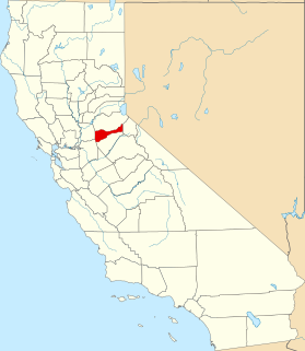
This is a list of the National Register of Historic Places listings in Amador County, California.

National Register of Historic Places listings in El Dorado County, California

This is a list of the National Register of Historic Places listings in El Dorado County, California.

National Register of Historic Places listings in Inyo County, California

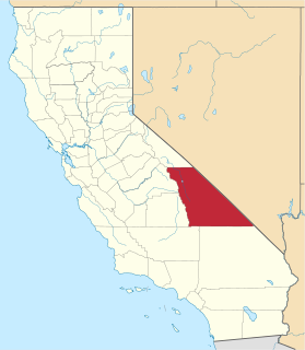
This is a list of the National Register of Historic Places listings in Inyo County, California.

National Register of Historic Places listings in Calaveras County, California

This is a list of the National Register of Historic Places listings in Calaveras County, California.

National Register of Historic Places listings in Merced County, California

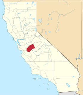
This is a list of the National Register of Historic Places listings in Merced County, California.

National Register of Historic Places listings in Tehama County, California

This is a list of the National Register of Historic Places listings in Tehama County, California.

National Register of Historic Places listings in Trinity County, California

This is a list of the National Register of Historic Places listings in Trinity County, California.

National Register of Historic Places listings in Madera County, California

This is a list of the National Register of Historic Places listings in Madera County, California.

References

  1. The latitude and longitude information provided in this table was derived originally from the National Register Information System, which has been found to be fairly accurate for about 99% of listings. Some locations in this table may have been corrected to current GPS standards.
  2. National Park Service, United States Department of the Interior, "National Register of Historic Places: Weekly List Actions", retrieved July 16, 2021.
  3. Numbers represent an alphabetical ordering by significant words. Various colorings, defined here, differentiate National Historic Landmarks and historic districts from other NRHP buildings, structures, sites or objects.
  4. "National Register Information System". National Register of Historic Places . National Park Service. July 9, 2010.
  5. The eight-digit number below each date is the number assigned to each location in the National Register Information System database, which can be viewed by clicking the number.