This is intended to be a complete list of the properties and districts on the National Register of Historic Places in the city of New Haven, Connecticut, United States. The locations of National Register properties and districts for which the latitude and longitude coordinates are included below, may be seen in an online map.[1]
There are 270 properties and districts listed on the National Register in New Haven County. The city of New Haven is the location of 68 of these properties and districts, including 9 National Historic Landmarks; they are listed here, while the other properties and districts in the remaining parts of the county, including 1 National Historic Landmark, are covered in National Register of Historic Places listings in New Haven County, Connecticut. Three sites appear in both New Haven County lists.
Contents: Counties and municipalities in Connecticut
A former synagogue whose elaborate facade demonstrates "design effort directed, with considerable success, toward establishing a Jewish presence in the streetscape."[6]
This neighborhood was developed in the early 1900s and was one of the first car-oriented neighborhoods in the region. It preserves Colonial Revival and other residential architecture.[7]
Built in 1883 as an investment by a former carriage manufacturer, the building was the first commercial + rental building in a residential area with very fine design and workmanship.[9]
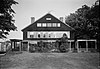
Home of Russell Henry Chittenden, the "father of American biochemistry", from 1887 to 1943.[11] The irregularly shaped three story house with Queen Anne elements was built in 1887 of brick, frame and shingling with gabled roof sections, gabled dormers, interior chimneys with corbeled caps, a square corner tower and a round-arched first-floor window.[12]
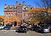
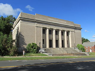
Home of the first agricultural experiment station in the United States. It was started in 1875 in Middletown and moved to New Haven in 1877. Its Osborne Library, built during 1882-83, is oldest building of any such station. Located at top of Prospect Hill, the station was the center of early research on vitamins.[14]
Georgian-style building from 1752 that is the oldest Yale University building and only survivor of the original Old Brick Row. Funded originally in part from the sale of a French ship, it was gutted and rebuilt in the 1950's.[15]
One of the oldest stone buildings in New Haven, the house has unusual sandstone quoining and a ballroom on the 3rd floor. Adjacent to the 1828 Caroline Nicoll House.[16]
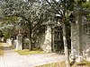
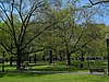
This 20-acre (8.1ha) historic district is a public park, the site of the estate of Frederick F. Brewster, the industrialist. The 1909 mansion was demolished in 1964 leaving the gatehouse, carriage house, greenhouses, other structures, and landscaped grounds.[17]:4,6 Extends into Hamden, elsewhere in New Haven County
Permanent school that grew out of a meeting of New Haven citizens in 1864. New Haven architect Henry Austin donated the design. Used as a school until 1874 when African-American children began attending previously all white public schools. The building was then used by African-American community organizations.[19]
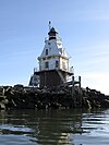
Completed in 1877, this lighthouse with Second Empire style architecture above, was the first or one of the first built on a cylindrical iron foundation, an innovation to address shifting ice that is regarded as very important in lighthouse design.
Former National Historic Landmark. Location of the First Telephone Exchange in the United States. Demolished in 1973 to make way for a parking garage.[26]
This is intended to be a complete list of the properties and districts on the National Register of Historic Places in Fairfield County, Connecticut, United States. The locations of National Register properties and districts for which the latitude and longitude coordinates are included below may be seen in an online map.
This is a list of the National Register of Historic Places designations in Hartford County, Connecticut.
This is a list of the National Register of Historic Places listings in Litchfield County, Connecticut.
The Connecticut Governor's Residence serves as the official home of the governor of Connecticut. It is located at 990 Prospect Avenue in Hartford.
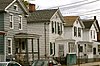
Edgewood Historic District is a historic district located in the west-central portion of New Haven, Connecticut. It was listed on the National Register of Historic Places in 1986. A predominantly residential area roughly bisected by Edgewood Avenue, a broad boulevard which features a large central esplanade and forms the principal east-west artery through the heart of the district. The area includes 232 contributing buildings, 4 other contributing structures, and 1 contributing object. Most of these were built between about 1888 and 1900, and represent the city's first neighborhood planned under the tenets of the City Beautiful movement. They are generally either Queen Anne or Colonial Revival in style, and are set on larger lots.
The Russell Henry Chittenden House is a historic house at 83 Trumbull Street in New Haven, Connecticut. Built in the 1880s, it was the longtime home of Russell Henry Chittenden, who lived there from 1887 to his death in 1943. Chittenden, known as the "father of American biochemistry", was a professor at Yale University, and the house was declared a National Historic Landmark in 1975 in recognition of his importance.
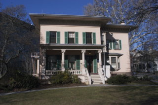
The James Dwight Dana House, also known as the Dana House, is a historic 19th-century Italianate house at 24 Hillhouse Avenue in New Haven, Connecticut, in the United States. This building, designed by New Haven architect Henry Austin, was the home of Yale University geology professor James Dwight Dana (1813–95). It was declared a National Historic Landmark in 1965 for its association with Dana, who produced the first published works emphasizing that the study of geology was a much broader discipline than the examination of individual rocks.
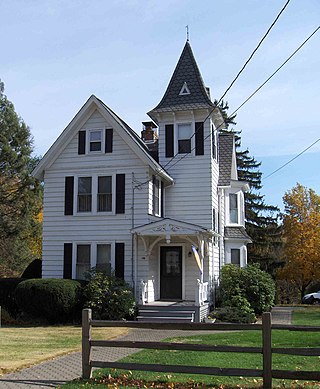
Marsh Hall, historically known as the Othniel C. Marsh House, is a historic house on Prospect Hill in New Haven, Connecticut. The property, which includes the house and a 6.8 acres (2.8 ha) grounds now known as Marsh Botanical Garden, was declared a National Historic Landmark in 1965. It was built in 1878 as the home of Othniel Marsh (1831–99), a leading 19th-century paleontologist, who occupied it until his death. The house is now owned by Yale University, and the building is occupied by the Yale School of the Environment.
The Beaver Hills Historic District is a 97-acre (39 ha) historic district in the Beaver Hills neighborhood of New Haven, Connecticut. It was listed on the National Register of Historic Places in 1986. In 1986, it included 235 contributing buildings.
Marion is a neighborhood in the town of Southington, Connecticut. It is generally the area in the vicinity of the intersection of Route 322 and Marion Avenue just north of the Cheshire town line.
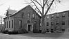
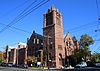
Plymouth Congregational Church, also known as Plymouth Church or Temple Keser Israel, is a former late-nineteenth-century Congregational Church at 1469 Chapel Street in New Haven, Connecticut. The church, a fine example of Romanesque Revival architecture, was listed on the National Register of Historic Places in 1983. The church is a notable example of an adaptive reuse, having been converted into a synagogue and medical office building.
J. Frederick Kelly (1888–1947) was an American architect who has designed significant houses. Kelly was regarded as the leading architectural historian in Connecticut.
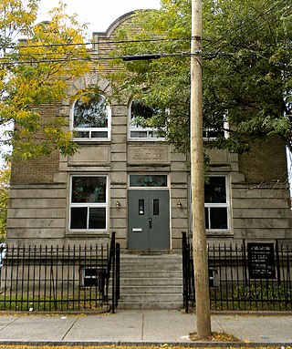
The Ahavas Sholem Synagogue, once known colloquially as The White Street Shul and now as the Thomas Hill Chapel, is a historic religious building at 30 White Street in New Haven, Connecticut. Built in 1928 for an Orthodox congregation founded in 1912, it is a distinctive example of a neighborhood synagogue with elaborate Neoclassical styling.
Temple B'Nai Israel is an historic former Jewish synagogue and former Masonic hall, located at 265 West Main Street in New Britain, Connecticut, in the United States.
The West Mountain Historic District is a 425-acre (172 ha) historic district northwest of the center of Ridgefield, Connecticut in Fairfield County, Connecticut that was listed on the National Register of Historic Places in 1984. It includes 12 contributing buildings. It is roughly centered on the junction of West Mountain Road and Oreneca Road, between Ridgefield center and the state line. It includes five large country estates developed in the early 20th century. Its "grandest" house is "Orenica", described as "a 1932 Georgian Revival style stone structure of considerable pretension" that was home of Philip Dakin Wagoner (1876-1972), chairman of the board of the Underwood Typewriter Company.
This is a list of the properties and historic districts in Stamford, Connecticut that are listed on the National Register of Historic Places. The locations of National Register properties and districts for which the latitude and longitude coordinates are included below, may be seen in an online map.
The Warner House is a historic house at 307 Town Street in East Haddam, Connecticut. Built in 1738, it is notable for its high quality interior woodwork and hardware, the latter of which were probably made by some of its owners. The house was listed on the National Register of Historic Places in 1987. The house is now owned by Connecticut Landmarks, and in 2019 it opened as a historic house museum.
William H. Allen (1858–1936) was an American architect who worked in New Haven, Connecticut. He designed hundreds of houses and other buildings.
West Mountain is a census-designated place (CDP) in the town of Ridgefield, Fairfield County, Connecticut, United States. It is on the west side of Ridgefield and is bordered to the west by the towns of North Salem and Lewisboro in Westchester County, New York. The West Mountain Historic District occupies 425 acres (172 ha) at the center of the CDP, and newer residences occupy portions of the remainder of the CDP.
References
↑ The latitude and longitude information provided in this table was derived originally from the National Register Information System, which has been found to be fairly accurate for about 99% of listings. Some locations in this table may have been corrected to current GPS standards.
1 2 Numbers represent an alphabetical ordering by significant words. Various colorings, defined here, differentiate National Historic Landmarks and historic districts from other NRHP buildings, structures, sites or objects.
↑ The eight-digit number below each date is the number assigned to each location in the National Register Information System database, which can be viewed by clicking the number.
↑ The portion of Edgewood Park west of the West River is officially included in the Westville neighborhood planning area. The West River Wildlife Sanctuary is officially part of the West River neighborhood planning area.
This page is based on this Wikipedia article Text is available under the CC BY-SA 4.0 license; additional terms may apply. Images, videos and audio are available under their respective licenses.