National Register of Historic Places listings in New River Gorge National River

Last updated

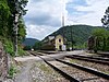
This is a list of the National Register of Historic Places listings in New River Gorge National River.

Contents

This is intended to be a complete list of the properties and districts on the National Register of Historic Places in New River Gorge National River, West Virginia, United States. The locations of National Register properties and districts for which the latitude and longitude coordinates are included below, may be seen in a Google map. [1]

National Register of Historic Places federal list of historic sites in the United States

The National Register of Historic Places (NRHP) is the United States federal government's official list of districts, sites, buildings, structures, and objects deemed worthy of preservation for their historical significance. A property listed in the National Register, or located within a National Register Historic District, may qualify for tax incentives derived from the total value of expenses incurred preserving the property.

New River Gorge National River

The New River Gorge National River is a unit of the United States National Park Service designed to protect and maintain the New River Gorge in southern West Virginia. Established in 1978, the NPS-protected area stretches for 53 miles (85 km) from just downstream of Hinton to Hawks Nest State Park near Ansted.

West Virginia State of the United States of America

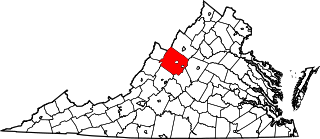
West Virginia is a state located in the Appalachian region in the Southern United States that is also considered to be a part of the Middle Atlantic States. It is bordered by Pennsylvania to the north, Maryland to the east and northeast, Virginia to the southeast, Kentucky to the southwest, and Ohio to the northwest. West Virginia is the 41st largest state by area, and is ranked 38th in population. The capital and largest city is Charleston.

There are six properties and districts listed on the National Register in the park, and one location outside the boundaries of the park, used as an administrative and interpretive site..

This National Park Service list is complete through NPS recent listings posted May 3, 2019. [2]
Map all coordinates using: OpenStreetMap  
Download coordinates as: KML  ·  GPX

Current listings

[3] Name on the RegisterImageDate listed [4] Location City or townDescription
1 Hinton Historic District
Hinton Historic District Hinton West Virginia.jpg
Hinton Historic District
February 17, 1984
(#84003670)
Roughly bounded by the Chesapeake & Ohio railroad line, James St., 5th Ave., and Roundhouse; also Hill St.
37°40′25″N80°53′11″W / 37.673611°N 80.886389°W / 37.673611; -80.886389 (Hinton Historic District)
Hinton
2 Kay Moor
Kay Moor Kay Moor conveyor.jpg
Kay Moor
November 8, 1990
(#90001641)
Along the New River south of U.S. Route 19
38°02′52″N81°03′53″W / 38.047778°N 81.064722°W / 38.047778; -81.064722 (Kay Moor)
Fayetteville
3 Nuttallburg Coal Mining Complex and Town Historic District
Nuttallburg Coal Mining Complex and Town Historic District Nuttallburg WV - Mine Conveyor.jpg
Nuttallburg Coal Mining Complex and Town Historic District
August 22, 2007
(#07000846)
County Route 85/2
38°03′02″N81°02′33″W / 38.050556°N 81.0425°W / 38.050556; -81.0425 (Nuttallburg Coal Mining Complex and Town Historic District)
Edmond
4 Prince Brothers General Store-Berry Store April 17, 1986
(#86000810)
WV 41
37°51′22″N81°03′49″W / 37.856111°N 81.063611°W / 37.856111; -81.063611 (Prince Brothers General Store-Berry Store)
Prince
5 Thurmond Historic District
Thurmond Historic District Thurmond WV Depot.jpg
Thurmond Historic District
January 27, 1984
(#84003520)
County Route 25/2 at New River
37°57′29″N81°04′40″W / 37.958056°N 81.077778°W / 37.958056; -81.077778 (Thurmond Historic District)
Thurmond
6 Trump-Lilly Farmstead
Trump-Lilly Farmstead Trump-Lilly Farmhouse.jpg
Trump-Lilly Farmstead
November 8, 1990
(#90001640)
County Route 26/3, 2.5 miles from County Route 26
37°41′54″N80°54′01″W / 37.698333°N 80.900278°W / 37.698333; -80.900278 (Trump-Lilly Farmstead)
Hinton Extends into Summers County

Associated sites

The following location is not within the boundaries of the National River, but is associated with interpretive or administrative facilities.

[3] Name on the RegisterImageDate listed [4] Location City or townDescription
2 Bank of Glen Jean
Bank of Glen Jean Bank of Glen Jean.jpg
Bank of Glen Jean
February 10, 1983
(#83003236)
Main St.
37°55′42″N81°09′19″W / 37.928333°N 81.155278°W / 37.928333; -81.155278 (Bank of Glen Jean)
Glen Jean

See also

National Register of Historic Places listings in Fayette County, West Virginia Wikimedia list article

This is a list of the National Register of Historic Places listings in Fayette County, West Virginia.

National Register of Historic Places listings in West Virginia Wikimedia list article

This is a list of properties and historic districts in West Virginia that are listed on the National Register of Historic Places. There are listings in every one of West Virginia's 55 counties.


Related Research Articles

National Register of Historic Places listings in Augusta County, Virginia Wikimedia list article

This is a list of the National Register of Historic Places listings in Augusta County, Virginia.

National Register of Historic Places listings in Botetourt County, Virginia Wikimedia list article

This is a list of the National Register of Historic Places listings in Botetourt County, Virginia.

National Register of Historic Places listings in Caroline County, Virginia Wikimedia list article

This is a list of the National Register of Historic Places listings in Caroline County, Virginia.

National Register of Historic Places listings in Charles City County, Virginia Wikimedia list article

This is a list of the National Register of Historic Places listings in Charles City County, Virginia.

National Register of Historic Places listings in Richmond, Virginia Wikimedia list article

This is a list of the National Register of Historic Places listings in Richmond, Virginia.

National Register of Historic Places listings in Dinwiddie County, Virginia Wikimedia list article

This is a list of the National Register of Historic Places listings in Dinwiddie County, Virginia.

National Register of Historic Places listings in Fluvanna County, Virginia Wikimedia list article

This is a list of the National Register of Historic Places listings in Fluvanna County, Virginia.

National Register of Historic Places listings in Halifax County, Virginia Wikimedia list article

This is a list of the National Register of Historic Places listings in Halifax County, Virginia.

National Register of Historic Places listings in Henry County, Virginia Wikimedia list article

This is a list of the National Register of Historic Places listings in Henry County, Virginia.

National Register of Historic Places listings in James City County, Virginia Wikimedia list article

This is a list of the National Register of Historic Places listings in James City County, Virginia.

National Register of Historic Places listings in King George County, Virginia Wikimedia list article

This is a list of the National Register of Historic Places listings in King George County, Virginia.

National Register of Historic Places listings in King William County, Virginia Wikimedia list article

This is a list of the National Register of Historic Places listings in King William County, Virginia.

National Register of Historic Places listings in Montgomery County, Virginia Wikimedia list article

This is a list of the National Register of Historic Places listings in Montgomery County, Virginia.

National Register of Historic Places listings in Northampton County, Virginia Wikimedia list article

This is a list of the National Register of Historic Places listings in Northampton County, Virginia.

National Register of Historic Places listings in Page County, Virginia Wikimedia list article

This is a list of the National Register of Historic Places listings in Page County, Virginia.

National Register of Historic Places listings in Roanoke, Virginia Wikimedia list article

This is a list of the National Register of Historic Places listings in Roanoke, Virginia.

National Register of Historic Places listings in Smyth County, Virginia Wikimedia list article

This is a list of the National Register of Historic Places listings in Smyth County, Virginia.

National Register of Historic Places listings in Surry County, Virginia Wikimedia list article

This is a list of the National Register of Historic Places listings in Surry County, Virginia.

National Register of Historic Places listings in Virginia Beach, Virginia Wikimedia list article

This is a list of the National Register of Historic Places listings in Virginia Beach, Virginia.

National Register of Historic Places listings in Hampshire County, West Virginia Wikimedia list article

This is a list of the National Register of Historic Places listings in Hampshire County, West Virginia.

References

  1. The latitude and longitude information provided in this table was derived originally from the National Register Information System, which has been found to be fairly accurate for about 99% of listings. For about 1% of NRIS original coordinates, experience has shown that one or both coordinates are typos or otherwise extremely far off; some corrections may have been made. A more subtle problem causes many locations to be off by up to 150 yards, depending on location in the country: most NRIS coordinates were derived from tracing out latitude and longitudes from USGS topographical quadrant maps created under the North American Datum of 1927 , which differs from the current, highly accurate WGS84 GPS system used by most on-line maps. Chicago is about right, but NRIS longitudes in Washington are higher by about 4.5 seconds, and are lower by about 2.0 seconds in Maine. Latitudes differ by about 1.0 second in Florida. Some locations in this table may have been corrected to current GPS standards.
  2. "National Register of Historic Places: Weekly List Actions". National Park Service, United States Department of the Interior. Retrieved on May 3, 2019.
  3. 1 2 Numbers represent an ordering by significant words. Various colorings, defined here, differentiate National Historic Landmarks and historic districts from other NRHP buildings, structures, sites or objects.
  4. 1 2 The eight-digit number below each date is the number assigned to each location in the National Register Information System database, which can be viewed by clicking the number.