National Register of Historic Places listings in Newton County, Georgia

Last updated

This is a list of properties and districts in Newton County, Georgia that are listed on the National Register of Historic Places (NRHP).

Map all coordinates using: OpenStreetMap  
Download coordinates as: KML


    This National Park Service list is complete through NPS recent listings posted May 20, 2022. [1]

Current listings

[2] Name on the RegisterImageDate listed [3] Location City or townDescription
1 Brick Store
Brick Store Brick Store.jpg
Brick Store
April 9, 2009
(#09000186)
U.S. Route 278 at Old Social Circle Road
33°36′07″N83°44′42″W / 33.601806°N 83.745°W / 33.601806; -83.745 (Brick Store)
Covington
2 Burge Farm
Burge Farm Burge Farm.jpg
Burge Farm
May 11, 2000
(#00000467)
Roughly bounded by GA 142, Cook Rd., Morehouse Rd. and Sewell Rd.
33°32′47″N83°43′47″W / 33.54629°N 83.72962°W / 33.54629; -83.72962 (Burge Farm)
Newborn
3 Covington Historic District August 6, 1998
(#98000969)
Roughly Covington City S of US 278
33°35′41″N83°51′12″W / 33.594722°N 83.853333°W / 33.594722; -83.853333 (Covington Historic District)
Covington
4 Covington Mills and Mill Village Historic District April 14, 2000
(#00000370)
Roughly bounded by Wheat, Collins and Lott Sts. and, to the north, the Covington Mills pond and Creek
33°36′19″N83°50′50″W / 33.605278°N 83.847222°W / 33.605278; -83.847222 (Covington Mills and Mill Village Historic District)
Covington
5 Floyd Street Historic District December 4, 1974
(#74000699)
Floyd St. from Elm to W of Sockwell St.
33°35′48″N83°51′20″W / 33.596667°N 83.855556°W / 33.596667; -83.855556 (Floyd Street Historic District)
Covington
6 Newborn Historic District August 6, 1998
(#98000970)
Roughly the entire city limits of Newborn City
33°31′09″N83°41′45″W / 33.519167°N 83.695833°W / 33.519167; -83.695833 (Newborn Historic District)
Newborn
7 Newton County Courthouse
Newton County Courthouse Newton County Georgia Courthouse.jpg
Newton County Courthouse
September 18, 1980
(#80001216)
Courthouse Sq.
33°35′49″N83°51′37″W / 33.596944°N 83.860278°W / 33.596944; -83.860278 (Newton County Courthouse)
Covington
8 North Covington Historic District May 26, 2000
(#00000526)
N. Emory and Odum Sts. and Georgia (CSX) Railroad
33°36′26″N83°51′48″W / 33.607222°N 83.863333°W / 33.607222; -83.863333 (North Covington Historic District)
Covington
9 Orna Villa
Orna Villa Orna Villa.JPG
Orna Villa
January 29, 1973
(#73000636)
1008 N. Emory St.
33°37′27″N83°51′59″W / 33.62408°N 83.86641°W / 33.62408; -83.86641 (Orna Villa)
Oxford
10 Oxford Historic District
Oxford Historic District Seney Hall.JPG
Oxford Historic District
June 5, 1975
(#75000603)
College and residential district centered around Wesley St.
33°37′32″N83°52′13″W / 33.625556°N 83.870278°W / 33.625556; -83.870278 (Oxford Historic District)
Oxford
11 Porterdale Historic District September 17, 2001
(#01000974)
Roughly the city limits of Porterdale north of Elm St.
33°34′23″N83°53′45″W / 33.573056°N 83.895833°W / 33.573056; -83.895833 (Porterdale Historic District)
Porterdale
12 Salem Camp Ground
Salem Camp Ground Salem Camp Ground.jpg
Salem Camp Ground
March 5, 1998
(#98000175)
3940 Salem Rd.
33°35′09″N83°58′00″W / 33.58576°N 83.9667°W / 33.58576; -83.9667 (Salem Camp Ground)
Covington
13 Starrsville Historic District June 26, 1998
(#98000715)
Jct. GA 213, Old Starsville and Dixie Rds.
33°31′44″N83°48′35″W / 33.528889°N 83.809722°W / 33.528889; -83.809722 (Starrsville Historic District)
Starrsville

Related Research Articles

National Register of Historic Places listings in Kansas

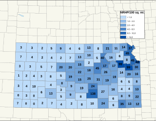
There are over 1,400 buildings, sites, districts, and objects in Kansas listed on the National Register of Historic Places in Kansas. NRHP listings appear in 101 of the state's 105 counties.

National Register of Historic Places listings in Essex County, Massachusetts

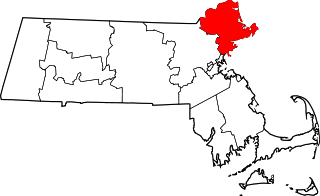
This list is of that portion of the National Register of Historic Places (NRHP) designated in Essex County, Massachusetts. The locations of these properties and districts for which the latitude and longitude coordinates are included below, may be seen in a map.

National Register of Historic Places listings in Allegany County, New York

This is intended to be a complete list of properties and districts listed on the National Register of Historic Places in Allegany County, New York. The locations of National Register properties and districts for which the latitude and longitude coordinates are included below, may be seen in a map.

National Register of Historic Places listings in Cattaraugus County, New York

This is intended to be a complete list of properties and districts listed on the National Register of Historic Places in Cattaraugus County, New York. The locations of National Register properties and districts for which the latitude and longitude coordinates are included below, may be seen in a map.

National Register of Historic Places listings in Cayuga County, New York

The following is a list of the National Register of Historic Places listings located in Cayuga County, New York:

National Register of Historic Places listings in Lycoming County, Pennsylvania

This is a list of the National Register of Historic Places listings in Lycoming County, Pennsylvania.

The following properties are listed on the National Register of Historic Places in Arlington, Massachusetts.
     This National Park Service list is complete through NPS recent listings posted May 20, 2022.

National Register of Historic Places listings in Riverside County, California

This is a list of the National Register of Historic Places listings in Riverside County, California.

National Register of Historic Places listings in Waynesboro, Virginia

This is a list of the National Register of Historic Places listings in Waynesboro, Virginia.

National Register of Historic Places listings in Bath County, Virginia

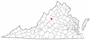
This is a list of the National Register of Historic Places listings in Bath County, Virginia.

National Register of Historic Places listings in Adams County, Pennsylvania

This is a list of the National Register of Historic Places listings in Adams County, Pennsylvania.

National Register of Historic Places listings in Centre County, Pennsylvania

This is a list of the National Register of Historic Places listings in Centre County, Pennsylvania.

National Register of Historic Places listings in Clinton County, Pennsylvania

This is a list of the National Register of Historic Places listings in Clinton County, Pennsylvania.

National Register of Historic Places listings in Juniata County, Pennsylvania

This is a list of the National Register of Historic Places listings in Juniata County, Pennsylvania.

National Register of Historic Places listings in Frederick County, Virginia

This is a list of the National Register of Historic Places listings in Frederick County, Virginia.

National Register of Historic Places listings in Garfield County, Utah

This is a list of the National Register of Historic Places listings in Garfield County, Utah.

National Register of Historic Places listings in Spartanburg County, South Carolina

This is a list of the National Register of Historic Places listings in Spartanburg County, South Carolina.

This is a list of the National Register of Historic Places listings in Cuyahoga Valley National Park.

National Register of Historic Places listings in Lubbock County, Texas

List of NRHP-registered historic places in Lubbock County, Texas

National Register of Historic Places listings in Barnstable, Massachusetts

Barnstable, Massachusetts, has more than 75 entries on the National Register of Historic Places. For listings elsewhere in Barnstable County, see National Register of Historic Places listings in Barnstable County, Massachusetts.

References

  1. National Park Service, United States Department of the Interior, "National Register of Historic Places: Weekly List Actions", retrieved May 20, 2022.
  2. Numbers represent an alphabetical ordering by significant words. Various colorings, defined here, differentiate National Historic Landmarks and historic districts from other NRHP buildings, structures, sites or objects.
  3. The eight-digit number below each date is the number assigned to each location in the National Register Information System database, which can be viewed by clicking the number.