National Register of Historic Places listings in Northampton County, Virginia

Last updated

Location of Northampton County in Virginia Map of Virginia highlighting Northampton County.svg
Location of Northampton County in Virginia

This is intended to be a complete list of the properties and districts on the National Register of Historic Places in Northampton County, Virginia, United States. The locations of National Register properties and districts for which the latitude and longitude coordinates are included below, may be seen in an online map. [1]

Contents

There are 30 properties and districts listed on the National Register in the county, including 2 National Historic Landmarks. Another 3 properties were once listed but have been removed.


    This National Park Service list is complete through NPS recent listings posted March 29, 2024. [2]

Current listings

[3] Name on the Register [4] ImageDate listed [5] Location City or townDescription
1 Almshouse Farm at Machipongo
Almshouse Farm at Machipongo Northhampton County Almshouse.jpg
Almshouse Farm at Machipongo
April 1, 2002
(#02000317)
12402 U.S. Route 13
37°24′16″N75°54′18″W / 37.404444°N 75.905000°W / 37.404444; -75.905000 (Almshouse Farm at Machipongo)
Machipongo
2 Arlington Archeological Site
Arlington Archeological Site Arlington Archeological Site overview.jpg
Arlington Archeological Site
May 12, 2008
(#08000422)
Address Restricted
Capeville
3 Benjamin's Department Store
Benjamin's Department Store Benjamin's Department Store.jpg
Benjamin's Department Store
May 10, 2006
(#06000367)
3327 Main St.
37°31′49″N75°49′20″W / 37.530278°N 75.822222°W / 37.530278; -75.822222 (Benjamin's Department Store)
Exmore
4 James Brown's Dry Goods Store
James Brown's Dry Goods Store James Brown's Dry Goods Store.jpg
James Brown's Dry Goods Store
April 1, 2002
(#02000321)
16464 Courthouse Rd.
37°21′07″N75°56′48″W / 37.351944°N 75.946667°W / 37.351944; -75.946667 (James Brown's Dry Goods Store)
Eastville
5 Brownsville
Brownsville Brownsville, State Routes 608 & 600 vicinity, Nassawadox vicinity (Northampton County, Virginia).jpg
Brownsville
February 26, 1970
(#70000819)
East of the junction of Seaside and Brownsville Rds.
37°28′24″N75°49′24″W / 37.473333°N 75.823333°W / 37.473333; -75.823333 (Brownsville)
Nassawadox
6 Cape Charles Historic District
Cape Charles Historic District CapeCharles-church-library.JPG
Cape Charles Historic District
January 3, 1991
(#90002122)
Roughly bounded by Washington, Bay, and Mason Aves., and Fig St.
37°16′11″N76°00′59″W / 37.269722°N 76.016389°W / 37.269722; -76.016389 (Cape Charles Historic District)
Cape Charles
7 Cape Charles Light Station
Cape Charles Light Station Cape charles light NPS.PNG
Cape Charles Light Station
June 23, 2003
(#03000569)
Smith Island
37°07′22″N75°54′24″W / 37.122778°N 75.906667°W / 37.122778; -75.906667 (Cape Charles Light Station)
Kiptopeke
8 Cape Charles Rosenwald School October 26, 2023
(#100009536)
1500 Old Cape Charles Road
37°15′48″N76°00′33″W / 37.2633°N 76.0092°W / 37.2633; -76.0092 (Cape Charles Rosenwald School)
Cape Charles
9 Cessford
Cessford Cessford, U.S. Route 13, Eastville vicinity (Northampton County, Virginia).jpg
Cessford
January 16, 2004
(#03001441)
16546 Courthouse Rd.
37°20′59″N75°56′53″W / 37.349861°N 75.948056°W / 37.349861; -75.948056 (Cessford)
Eastville
10 John W. Chandler House
John W. Chandler House John W Chandler House.jpg
John W. Chandler House
November 27, 2004
(#04001270)
3342 Main St.
37°31′48″N75°49′24″W / 37.530000°N 75.823333°W / 37.530000; -75.823333 (John W. Chandler House)
Exmore
11 Chatham September 20, 2022
(#100008186)
9218 Chatham Rd.
37°27′22″N75°55′38″W / 37.4562°N 75.9273°W / 37.4562; -75.9273 (Chatham)
Machipongo vicinity
12 Custis Tombs
Custis Tombs John Custis IV tomb HABS VA1.jpg
Custis Tombs
April 17, 1970
(#70000815)
Arlington Chase Rd.
37°13′45″N76°00′13″W / 37.229028°N 76.003750°W / 37.229028; -76.003750 (Custis Tombs)
Cheapside
13 Eastville Historic District
Eastville Historic District Eastville Courthouse.JPG
Eastville Historic District
October 1, 2009
(#09000795)
Area includes U.S. Route 13, Old Town Neck Dr., Courthouse Rd., Willow Oak Rd., Rockefellow La., and Stumptown Dr.
37°21′10″N75°56′44″W / 37.352778°N 75.945556°W / 37.352778; -75.945556 (Eastville Historic District)
Eastville
14 Eastville Mercantile
Eastville Mercantile Eastville Mercantile.jpg
Eastville Mercantile
January 20, 2005
(#04001540)
16429 Courthouse Rd.
37°21′10″N75°56′46″W / 37.352694°N 75.946111°W / 37.352694; -75.946111 (Eastville Mercantile)
Eastville
15 Eyre Hall
Eyre Hall Eyre hall (dnr).jpg
Eyre Hall
November 12, 1969
(#69000265)
West of U.S. Route 13
37°18′48″N75°58′54″W / 37.313333°N 75.981667°W / 37.313333; -75.981667 (Eyre Hall)
Cheriton
16 Eyreville March 15, 2024
(#69000265)
3259 Eyreville Drive
37°19′17″N75°58′55″W / 37.3213°N 75.9820°W / 37.3213; -75.9820 (Eyreville)
Cheriton vicinity
17 Glebe of Hungar's Parish
Glebe of Hungar's Parish Glebe of Hungar's Parish close up.jpg
Glebe of Hungar's Parish
February 26, 1970
(#70000817)
Northwest of the junction of Glebe and Church Neck Rds.
37°27′38″N75°57′34″W / 37.460556°N 75.959444°W / 37.460556; -75.959444 (Glebe of Hungar's Parish)
Franktown
18 Grapeland
Grapeland Grapeland west of Exmore.jpg
Grapeland
May 6, 1980
(#80004207)
Grapeland Circle, north of Wardtown [6]
37°32′40″N75°52′54″W / 37.544444°N 75.881667°W / 37.544444; -75.881667 (Grapeland)
Wardtown
19 Hungars Church
Hungars Church Hungar's Church, State Route 619, Bridgetown vicinity (Northampton County, Virginia).jpg
Hungars Church
October 15, 1970
(#70000813)
East of the junction of Bayside and Church Neck Rds.
37°26′47″N75°55′26″W / 37.446250°N 75.923889°W / 37.446250; -75.923889 (Hungars Church)
Bridgetown
20 Kendall Grove
Kendall Grove Kendall Grove, State Route 674, Eastville vicinity (Northampton County, Virginia).jpg
Kendall Grove
June 21, 1982
(#82004576)
Kendall Grove Rd.
37°22′56″N75°56′34″W / 37.382222°N 75.942778°W / 37.382222; -75.942778 (Kendall Grove)
Eastville
21 Northampton County Courthouse Historic District
Northampton County Courthouse Historic District Northampton County Courthouse Historical District Eastville Courthouse.jpg
Northampton County Courthouse Historic District
April 13, 1972
(#72001410)
East along U.S. Route 13 and extending 0.1 miles (0.16 km) to the west, north, and south from its intersection with Willow Oak Rd.
37°21′12″N75°56′48″W / 37.353333°N 75.946667°W / 37.353333; -75.946667 (Northampton County Courthouse Historic District)
Eastville
22 Northampton Lumber Company Historic District
Northampton Lumber Company Historic District Northampton Lumber Company main building.jpg
Northampton Lumber Company Historic District
May 29, 2008
(#08000480)
Junction of U.S. Route 13 and Mill St.
37°28′24″N75°51′30″W / 37.473333°N 75.858333°W / 37.473333; -75.858333 (Northampton Lumber Company Historic District)
Nassawadox
23 Oak Grove February 4, 1993
(#93000006)
Northern side of Old Town Neck Dr., 1 mile (1.6 km) west of the junction with US 13
37°23′16″N75°57′23″W / 37.387778°N 75.956389°W / 37.387778; -75.956389 (Oak Grove)
Eastville
24 Pear Valley
Pear Valley Pear Valley.jpg
Pear Valley
November 12, 1969
(#69000266)
South of the junction of Wilsonia Neck and Pear Cottage Drs.
37°23′48″N75°55′22″W / 37.396667°N 75.922778°W / 37.396667; -75.922778 (Pear Valley)
Eastville
25 Selma
Selma Selma at Eastville.jpg
Selma
May 10, 2006
(#06000368)
16237 Courthouse Rd.
37°21′25″N75°56′32″W / 37.357083°N 75.942222°W / 37.357083; -75.942222 (Selma)
Eastville
26 Stratton Manor
Stratton Manor Stratton Manor, State Route 642 vicinity, Cheriton vicinity (Northampton County, Virginia).jpg
Stratton Manor
November 28, 1980
(#80004206)
Southeast of Cape Charles off Parsons Circle
37°15′42″N75°59′00″W / 37.261528°N 75.983333°W / 37.261528; -75.983333 (Stratton Manor)
Cape Charles
27 Upper Ridge Site August 23, 2005
(#05000914)
Atlantic Ocean beach [7]
37°13′19″N75°53′04″W / 37.221944°N 75.884444°W / 37.221944; -75.884444 (Upper Ridge Site)
Mockhorn Island
28 Vaucluse
Vaucluse Vaucluse, State Route 619, Bridgetown vicinity (Northampton County, Virginia).jpg
Vaucluse
September 15, 1970
(#70000814)
South of the junction of Church Neck and Sparrow Pt. Rds.
37°25′05″N75°58′23″W / 37.418056°N 75.973056°W / 37.418056; -75.973056 (Vaucluse)
Bridgetown
29 Westerhouse House November 19, 1974
(#74002139)
West of Bridgetown off Church Neck Rd.
37°26′52″N75°58′06″W / 37.447639°N 75.968472°W / 37.447639; -75.968472 (Westerhouse House)
Bridgetown
30 Winona
Winona Winona HABS VA1.jpg
Winona
October 1, 1969
(#69000264)
Southwest of the junction of Glebe and Church Neck Rds.
37°26′25″N75°56′08″W / 37.440139°N 75.935556°W / 37.440139; -75.935556 (Winona)
Bridgetown

Former listings

[3] Name on the RegisterImageDate listedDate removedLocationCity or townDescription
1 Caserta
Caserta Caserta HABS VA1.jpg
Caserta
February 26, 1970
(#70000816)
March 19, 2001NW of junction of Routes 630 and US 13
Eastville Destroyed by fire in 1975
2 Somers House
Somers House Somers House HABS VA1.jpg
Somers House
February 26, 1970
(#70000818)
June 10, 2005SE of jct. of Rtes. 183 and 691
Jamesville Demolished
3 Westover
Westover Westover Eastville HABS VA1.jpg
Westover
June 28, 1982
(#82004577)
March 19, 2001VA 630
Eastville Destroyed by fire

See also

Related Research Articles

<span class="mw-page-title-main">National Register of Historic Places listings in Alleghany County, Virginia</span>

This is a list of the National Register of Historic Places listings in Alleghany County, Virginia.

<span class="mw-page-title-main">National Register of Historic Places listings in Amelia County, Virginia</span>

This is a list of the National Register of Historic Places listings in Amelia County, Virginia.

<span class="mw-page-title-main">National Register of Historic Places listings in Bedford County, Virginia</span>

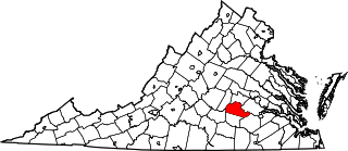
This is a list of the National Register of Historic Places listings in Bedford County, Virginia.

<span class="mw-page-title-main">National Register of Historic Places listings in Washington County, Virginia</span>

This is a list of the National Register of Historic Places listings in Washington County, Virginia.

<span class="mw-page-title-main">National Register of Historic Places listings in Clarke County, Virginia</span>

This is a list of the National Register of Historic Places listings in Clarke County, Virginia.

<span class="mw-page-title-main">National Register of Historic Places listings in Dickenson County, Virginia</span>

This is a list of the National Register of Historic Places listings in Dickenson County, Virginia.

<span class="mw-page-title-main">National Register of Historic Places listings in Goochland County, Virginia</span>

This is a list of the National Register of Historic Places listings in Goochland County, Virginia.

<span class="mw-page-title-main">National Register of Historic Places listings in Greene County, Virginia</span>

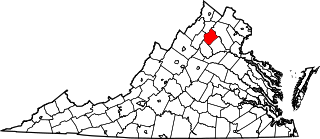
This is a list of the National Register of Historic Places listings in Greene County, Virginia.

<span class="mw-page-title-main">National Register of Historic Places listings in King George County, Virginia</span>

This is a list of the National Register of Historic Places listings in King George County, Virginia.

<span class="mw-page-title-main">National Register of Historic Places listings in New Kent County, Virginia</span>

This is a list of the National Register of Historic Places listings in New Kent County, Virginia.

<span class="mw-page-title-main">National Register of Historic Places listings in Orange County, Virginia</span>

This is a list of the National Register of Historic Places listings in Orange County, Virginia.

<span class="mw-page-title-main">National Register of Historic Places listings in Rappahannock County, Virginia</span>

This is a list of the National Register of Historic Places listings in Rappahannock County, Virginia.

<span class="mw-page-title-main">National Register of Historic Places listings in Shenandoah County, Virginia</span>

This is a list of the National Register of Historic Places listings in Shenandoah County, Virginia.

<span class="mw-page-title-main">National Register of Historic Places listings in Wythe County, Virginia</span>

This is a list of the National Register of Historic Places listings in Wythe County, Virginia.

<span class="mw-page-title-main">National Register of Historic Places listings in Prince Edward County, Virginia</span>

This is a list of the National Register of Historic Places listings in Prince Edward County, Virginia.

<span class="mw-page-title-main">National Register of Historic Places listings in Northampton County, North Carolina</span>

This list includes properties and districts listed on the National Register of Historic Places in Northampton County, North Carolina. Click the "Map of all coordinates" link to the right to view an online map of all properties and districts with latitude and longitude coordinates in the table below.

<span class="mw-page-title-main">National Register of Historic Places listings in Hampshire County, West Virginia</span>

This is a list of the National Register of Historic Places listings in Hampshire County, West Virginia.

<span class="mw-page-title-main">National Register of Historic Places listings in Hancock County, West Virginia</span>

This is a list of the National Register of Historic Places listings in Hancock County, West Virginia.

<span class="mw-page-title-main">National Register of Historic Places listings in Buchanan County, Virginia</span>

This is a list of the National Register of Historic Places listings in Buchanan County, Virginia.

<span class="mw-page-title-main">National Register of Historic Places listings in Grayson County, Virginia</span>

This is a list of the National Register of Historic Places listings in Grayson County, Virginia.

References

  1. The latitude and longitude information provided in this table was derived originally from the National Register Information System, which has been found to be fairly accurate for about 99% of listings. Some locations in this table may have been corrected to current GPS standards.
  2. National Park Service, United States Department of the Interior, "National Register of Historic Places: Weekly List Actions", retrieved March 29, 2024.
  3. 1 2 Numbers represent an alphabetical ordering by significant words. Various colorings, defined here, differentiate National Historic Landmarks and historic districts from other NRHP buildings, structures, sites or objects.
  4. "National Register Information System". National Register of Historic Places . National Park Service. April 24, 2008.
  5. The eight-digit number below each date is the number assigned to each location in the National Register Information System database, which can be viewed by clicking the number.
  6. Location derived from its coordinates; the NRIS lists the site as "Address Restricted" but provides coordinates
  7. Egloff, Keith T. National Register of Historic Places Inventory/Nomination: Upper Ridge Site. National Park Service, 2005-05, 20.