The following is a list of Registered Historic Places in Oakland County, Michigan.
This National Park Service list is complete through NPS recent listings posted July 14, 2023. [1]
Contents
| [2] | Name on the Register [3] | Image | Date listed [4] | Location | City or town | Description |
|---|---|---|---|---|---|---|
| 1 | Gregor S. and Elizabeth B. Affleck House |  | October 3, 1985 (#85003005) | 1925 N. Woodward Ave. 42°35′17″N83°14′59″W / 42.588056°N 83.249722°W | Bloomfield Hills | |
| 2 | Eli and Sidney Teeter Albertson House |  | December 12, 2002 (#02001505) | 4480 Sheldon Rd. 42°44′02″N83°07′35″W / 42.733889°N 83.126389°W | Oakland Township | |
| 3 | Royal Aldrich House |  | August 19, 1994 (#94000755) | 31110 W. 11 Mile Rd. 42°29′06″N83°21′24″W / 42.485°N 83.356667°W | Farmington Hills | |
| 4 | Andrews-Leggett House |  | June 12, 1987 (#87000949) | 722 Farr St. 42°35′39″N83°29′25″W / 42.594167°N 83.490278°W | Commerce Township | |
| 5 | Apple Island Historic Archaeological Site |  | July 20, 2018 (#100002685) | Approx. 1/2 mi. from 4549 Commerce Rd. 42°35′21″N83°22′21″W / 42.5891°N 83.3726°W | Orchard Lake Village | |
| 6 | Axford-Coffin Farm |  | March 15, 2002 (#02000159) | 384-388 W. Predmore Rd. 42°47′10″N83°08′41″W / 42.786111°N 83.144722°W | Oakland Township | |
| 7 | B and C Grocery Building |  | March 22, 2006 (#06000149) | 417-19 S. Main St. 42°29′09″N83°08′39″W / 42.485833°N 83.144167°W | Royal Oak | Constructed in 1946; features a metal panel Art Modern facade. |
| 8 | Botsford Inn |  | September 19, 1979 (#79003173) | 28000 Grand River Ave. 42°26′38″N83°19′23″W / 42.443889°N 83.323056°W | Farmington | |
| 9 | Botsford-Graser House |  | March 15, 2002 (#02000158) | 24105 Locust Dr. 42°28′13″N83°23′04″W / 42.470278°N 83.384444°W | Farmington Hills | |
| 10 | Brooks Farm |  | March 16, 1972 (#72001594) | 3521 Big Beaver Rd. 42°33′39″N83°11′28″W / 42.560833°N 83.191111°W | Troy | The William Brooks Farm, also known as the Washington Stanley Farm, contains an 1852 fieldstone farmhouse and associated outbuildings. Troy pioneer Washington Stanley and his descendants farmed here from 1826-1911; the William Brooks family used it as a dairy until the 1960s. It is currently the headquarters of the Kresge Foundation. |
| 11 | Elijah Bull House | June 29, 2022 (#100007893) | 6115 Wing Lake Rd. 42°33′00″N83°17′37″W / 42.55°N 83.293611°W | Bloomfield Township | ||
| 12 | Casa del Rey Apartments |  | June 29, 1989 (#89000787) | 111 Oneida Rd. 42°37′57″N83°18′39″W / 42.6325°N 83.310833°W | Pontiac | |
| 13 | Caswell House |  | January 13, 1972 (#72000650) | 60 W. Wattles Rd. 42°34′40″N83°09′03″W / 42.577778°N 83.150833°W | Troy | An especially well-preserved example of Greek Revival architecture. The home was built by Solomon and Hulda Caswell in 1832, and Caswell's descendants occupied it until 1965, when William Caswell, Solomon's grandson, died a bachelor. In 1968, the house was moved from its original location, and it is now part of the Troy Museum and Historic Village. |
| 14 | Central School |  | February 16, 1984 (#84001809) | 101 E. Pike St. 42°38′16″N83°17′18″W / 42.637778°N 83.288333°W | Pontiac | |
| 15 | Clarkston Village Historic District |  | May 15, 1980 (#80001884) | M-15 42°44′11″N83°25′08″W / 42.736389°N 83.418889°W | Clarkston Village | Located in the southern part of Independence Township along M-15. The historic district includes Buffalo Street, Church Street, Clarkston Road, Depot Road, Holcomb Street, Main Street (M-15), Miller Road, Waldon Road and Washington Street, and includes over 100 historic structures. |
| 16 | Clinton-Kalamazoo Canal |  | March 24, 1972 (#72000638) | Runs between Utica and Yates 42°39′17″N83°03′10″W / 42.654722°N 83.052778°W | Utica | The Clinton–Kalamazoo Canal was begun in 1838, with the plan of connecting Mount Clemens to the mouth of the Kalamazoo River. However, funding quickly dried up, and all construction stopped in 1843 after only 13 miles had been completed. The remains of the canal extend into both Oakland County and Macomb County. |
| 17 | Cranbrook |  | March 7, 1973 (#73000954) | Lone Pine Rd. 42°34′15″N83°14′52″W / 42.570833°N 83.247778°W | Bloomfield Hills | The Cranbrook Educational Community was founded in the early 20th century by newspaper mogul George Gough Booth. The campus began as a farm, purchased in 1904, and now consists of Cranbrook Schools, Cranbrook Academy of Art, Cranbrook Art Museum, Cranbrook Institute of Science and Cranbrook House and Gardens. Much of the campus was designed by Albert Kahn and Eliel Saarinen, and sculptors Carl Milles and Marshall Fredericks also spent many years in residence at Cranbrook. |
| 18 | Derby Street-Grand Trunk Western Railroad Bridge |  | January 27, 2000 (#99001730) | Derby St. over Grand Trunk Western Railroad 42°33′15″N83°12′11″W / 42.554167°N 83.203056°W | Birmingham | |
| 19 | Detroit Finnish Co-operative Summer Camp |  | January 25, 2007 (#06000723) | 2524 Loon Lake Rd. 42°32′55″N83°31′03″W / 42.548478°N 83.51745°W | Wixom | The Detroit Finnish Cooperative Summer Camp is a camping facility started in 1925 by a group of Detroit-area people of Finnish descent to preserve and share the traditions of their native land. |
| 20 | Detroit Zoological Park | 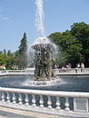 | August 24, 1990 (#90001226) | 8450 W. Ten Mile Rd. 42°28′38″N83°09′26″W / 42.477222°N 83.157222°W | Huntington Woods/Royal Oak | The Detroit Zoo opened in 1928, and has periodically expanded since then. Currently situated on 125 acres of land, it provides a natural habitat for more than 3,300 animals representing 280 species, and hosts more than 1.1 million visitors annually. |
| 21 | Downtown Holly Commercial District |  | April 25, 1986 (#86000866) | Roughly bounded by Maple St., S. Broad St., Grand Trunk Western Railroad, and First St. 42°47′32″N83°37′38″W / 42.792222°N 83.627222°W | Holly | |
| 22 | Eagle Theater |  | February 16, 1984 (#84001810) | 11-15 S. Saginaw St. 42°38′14″N83°17′32″W / 42.637222°N 83.292222°W | Pontiac | |
| 23 | Eastern Michigan Asylum Historic District | 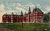 | March 20, 1981 (#81000315) | 140 Elizabeth Lake Rd. 42°38′47″N83°19′05″W / 42.646389°N 83.318056°W | Pontiac | The Eastern Michigan Asylum (later the Pontiac State Hospital, then the Clinton Valley Center) was a psychiatric hospital built according to the Kirkbride Plan. Designed by Michigan State Capitol architect Elijah E. Myers, the facility opened in 1878. Despite treating 3100 patients at its peak, usage declined and the facility was closed in 1997 and demolished in 2000. [5] The boundaries of the historic district were decrease in 1986. |
| 24 | John & Mary Elizabeth Booth Endicott House |  | March 25, 2008 (#08000223) | 290 Chesterfield 42°33′47″N83°13′53″W / 42.563056°N 83.231389°W | Bloomfield Hills | |
| 25 | Caleb Everts House |  | October 14, 1980 (#80001886) | 8880 Hickory Ridge Rd. 42°43′33″N83°39′49″W / 42.725833°N 83.663611°W | Davisburg | |
| 26 | Fairgrove Avenue Historic District |  | January 31, 1985 (#85000166) | Along Fairgrove Ave. between N. Saginaw and Edison Sts. 42°38′39″N83°17′34″W / 42.644167°N 83.292778°W | Pontiac | |
| 27 | Farmington Historic District | 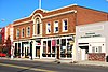 | June 18, 1976 (#76001034) | Grand River Ave. and Shiawassee Ave. from Warner St. to junction 42°27′56″N83°22′41″W / 42.465556°N 83.378056°W | Farmington | |
| 28 | First Methodist Episcopal Church of Farmington |  | August 25, 2014 (#14000512) | 33112 Grand River Ave. 42°27′51″N83°22′25″W / 42.464097°N 83.373674°W | Farmington | |
| 29 | Dr. Henry K. Foote House |  | January 11, 1985 (#85000062) | 213 W. Huron St. 42°35′06″N83°36′07″W / 42.585°N 83.601944°W | Milford | |
| 30 | Franklin Boulevard Historic District |  | August 11, 1983 (#83000888) | Roughly bounded by Grand Trunk Western Railroad, Orchard Lake Ave., Miller and W. Huron Sts. 42°38′06″N83°18′07″W / 42.635°N 83.301944°W | Pontiac | |
| 31 | Franklin Historic District |  | February 10, 1969 (#69000070) | Roughly bounded by Fourteen Mile Rd., the Franklin River, Romany Wy., and Franklin Rd. 42°31′43″N83°18′18″W / 42.528611°N 83.305°W | Franklin | Boundary increase (added 2005-07-27): Franklin Rd. and adjoining Sts. |
| 32 | Jacob and Rebecca Fuerst Farmstead |  | August 21, 1997 (#97000928) | 24000 Taft Rd. 42°27′54″N83°29′36″W / 42.465°N 83.493333°W | Novi | The farmstead was demolished in 2008. [6] |
| 33 | Gillespie Street-Clinton River Bridge | 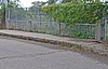 | January 27, 2000 (#99001729) | Gillespie St. over Clinton River 42°37′34″N83°17′52″W / 42.626111°N 83.297778°W | Pontiac | |
| 34 | John Grace School |  | April 6, 2023 (#100008828) | 21030 Indian St. 42°26′44″N83°18′42″W / 42.445556°N 83.311667°W | Southfield | |
| 35 | Grand Trunk Western Railroad Birmingham Depot |  | September 12, 1985 (#85002148) | 245 S. Eton St. 42°32′48″N83°11′42″W / 42.546667°N 83.195°W | Birmingham | |
| 36 | Griggs Brothers-Rochester Elevator Company Grain Elevator |  | December 13, 2010 (#10001028) | 303 East University Drive 42°40′55″N83°07′54″W / 42.681944°N 83.131667°W | Rochester | 1880 wooden grain elevator on the Michigan Central Railroad critical to the agrarian economy of the region through the mid-20th century. [7] |
| 37 | Grinnell Brothers Music House | 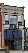 | April 19, 1984 (#84001812) | 27 S. Saginaw St. 42°38′10″N83°17′31″W / 42.636111°N 83.291944°W | Pontiac | |
| 38 | Highland United Methodist Church |  | July 9, 1981 (#81000314) | 205 W. Livingston Rd. 42°38′15″N83°37′10″W / 42.6375°N 83.619444°W | Highland | Historic Gothic Revival church building; constructed in 1886. The Hickory Ridge School, built in 1835, was moved to the site in 1946 and serves as the rear addition. In 1980, the building was purchased by Highland Township, and the structure currently known houses the Huron Valley Council for the Arts. |
| 39 | Hilzinger Block |  | May 17, 2006 (#06000403) | 106-110 S. Main St. 42°29′23″N83°08′41″W / 42.489722°N 83.144722°W | Royal Oak | Completed in 1925 for the Hilzinger Hardware Store. The store occupied the building until 2002, after which the facade was renovated to match the original appearance. |
| 40 | Hirst Hotel |  | February 8, 1980 (#80001887) | 110 Battle Alley 42°47′27″N83°37′36″W / 42.790833°N 83.626667°W | Holly | |
| 41 | Holly Union Depot | 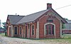 | December 21, 2000 (#00000645) | 223 S. Broad St. 42°47′21″N83°37′27″W / 42.789167°N 83.624167°W | Holly | |
| 42 | Horatio N. Howard House |  | December 27, 1984 (#84000545) | 403 N. Saginaw 42°38′50″N83°17′41″W / 42.647222°N 83.294722°W | Pontiac | |
| 43 | Hubbard-Kesby House |  | June 3, 1996 (#96000612) | 1965 W. Dawson Rd. 42°33′49″N83°38′08″W / 42.563611°N 83.635556°W | Milford | |
| 44 | John W. Hunter House |  | January 13, 1972 (#72000648) | 556 W. Maple Rd. 42°32′48″N83°13′10″W / 42.546667°N 83.219444°W | Birmingham | |
| 45 | Indian Lake Road Stone Arch Bridge |  | July 22, 2005 (#05000712) | Indian Lake Rd., east of M-24 42°47′51″N83°14′47″W / 42.7975°N 83.246389°W | Orion Township | Currently used as part of a walk/bike path over Indian Lake Road. |
| 46 | Lake Orion Historic District |  | August 23, 2006 (#06000722) | Roughly bounded by Elizabeth St., Hauxwell Dr., Front St., and Lapeer St. 42°47′10″N83°14′19″W / 42.786111°N 83.238611°W | Lake Orion | |
| 47 | Lathrup Village Historic District |  | March 16, 1998 (#98000150) | Roughly bounded by city limits, Red River Dr., Interstate 696, Middlesex Ave., Meadowbrook Way, and Margate Ave. 42°29′35″N83°13′35″W / 42.493056°N 83.226389°W | Lathrup Village | |
| 48 | Lower Trout Lake Bathhouse Complex and Contact Station |  | September 3, 2013 (#13000670) | Bald Mountain Recreation Area Entrance Drive (Orion Township, Michigan) 42°44′19″N83°13′25″W / 42.738484°N 83.223623°W | Auburn Hills vicinity | |
| 49 | Kittie C. McCoy House |  | March 25, 2009 (#08001105) | 1455 Benstein Road 42°32′40″N83°30′12″W / 42.544444°N 83.503333°W | Commerce Township | |
| 50 | Meadow Brook Farms |  | April 17, 1979 (#79001166) | 480 S. Adams Rd. 42°40′23″N83°11′55″W / 42.673056°N 83.198611°W | Rochester vicinity | Also known as Meadow Brook Farm. Tudor Revival mansion built between 1926 and 1929 by Matilda Dodge Wilson (the widow of auto pioneer John Francis Dodge) and her second husband, lumber broker Alfred G. Wilson. In 1957, the mansion and the surrounding property and buildings were donated to establish Michigan State University–Oakland, now Oakland University. |
| 51 | Milford Rural Agricultural School |  | January 22, 1992 (#91001995) | 630 Hickory St. 42°35′38″N83°35′52″W / 42.593889°N 83.597778°W | Milford | |
| 52 | Modern Housing Corporation Addition Historic District |  | June 9, 1989 (#89000490) | Roughly bounded by Montcalm St., Perry St., Joslyn Ave., Gage St., Glenwood, and Nelson St. 42°39′13″N83°16′44″W / 42.653611°N 83.278889°W | Pontiac | |
| 53 | Myrick-Palmer House | 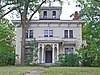 | July 8, 1970 (#70000283) | 223 W. Huron St. 42°38′12″N83°18′04″W / 42.636667°N 83.301111°W | Pontiac | |
| 54 | Milo Prentice Newberry House | October 9, 2018 (#100002997) | 705 Bloomer Rd. 42°40′37″N83°07′09″W / 42.6770°N 83.1192°W | Rochester | ||
| 55 | North Milford Village Historic District | 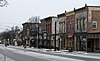 | April 21, 2000 (#00000391) | Historic area of North Milford Village 42°35′26″N83°35′51″W / 42.590556°N 83.5975°W | Milford | |
| 56 | Northland Gardens | January 24, 2020 (#100004660) | Westland Ave., Westhampton Rd., Rutland Dr., and Westover Rd. between Southfield Rd., & the John C. Lodge Freeway 42°26′50″N83°12′52″W / 42.4473°N 83.2145°W | Southfield | ||
| 57 | H. Augustus and Agnes Cleveland O'Dell House-Inch House | March 17, 2009 (#09000129) | 1945 Tiverton Road 42°35′16″N83°14′40″W / 42.587778°N 83.244444°W | Bloomfield Hills | ||
| 58 | Oak Hill Cemetery |  | June 20, 1989 (#89000493) | 216 University Dr. 42°38′34″N83°17′07″W / 42.642778°N 83.285278°W | Pontiac | |
| 59 | Orchard Lake Schools Historic District |  | March 19, 1982 (#82002859) | Indian Trail 42°35′38″N83°21′28″W / 42.593889°N 83.357778°W | Orchard Lake | Encompasses the area occupied in 1877 for the Michigan Military Academy, an all-boys military prep school established by Captain J. Sumner Rogers. The school closed in 1908 due to bankruptcy, and in 1910 the Polish Seminary of Detroit purchased the campus moved the school (now SS. Cyril and Methodius Seminary) there. The campus is also home to St. Mary's Preparatory, and is used by nearby Madonna University. |
| 60 | Ortonville Mill |  | April 16, 1971 (#71000416) | 366 Mill St. 42°51′07″N83°26′45″W / 42.851944°N 83.445833°W | Ortonville | |
| 61 | Oxford Downtown Historic District |  | July 15, 2019 (#100004158) | Washington St./MI-24 and Burdick St. 42°49′29″N83°15′54″W / 42.8248°N 83.2649°W | Oxford | |
| 62 | Pleasant Ridge East Historic District |  | February 1, 2007 (#06001329) | Bounded generally by Woodward, 10 Mile Rd., Conrail, and eastern and southern city limits 42°28′14″N83°08′13″W / 42.470556°N 83.136944°W | Pleasant Ridge | |
| 63 | Pleasant Ridge Historic District |  | August 11, 1992 (#92000165) | Roughly bounded by Millington Rd., Woodward Ave., Ferndale and Ridge Rd. Boundary increase (listed December 13, 2010): West of Ridge Rd. to city limits of Royal Oak, Huntington Woods, Oak Park, and Ferndale. 42°28′14″N83°08′43″W / 42.4706°N 83.1453°W | Pleasant Ridge | |
| 64 | Plumbrooke Estates | November 22, 2019 (#100004661) | Plumbrooke Dr. 42°27′41″N83°14′54″W / 42.4613°N 83.2483°W | Southfield | ||
| 65 | Pontiac Commercial Historic District |  | February 16, 1984 (#84001817) | 1-29 N. Saginaw St., 5-29 W. Lawrence St., and 10-18 W. Pike St. 42°38′13″N83°17′35″W / 42.636944°N 83.293056°W | Pontiac | Boundary increase (added 1989-06-23): Roughly E. Huron St. and S. Saginaw St. within loop of Wide Track Dr. |
| 66 | Walter P. and May Wolf Reuther House | June 20, 2002 (#02000668) | 3924-3950-3954 Ellamae (Oakland Township) 42°44′28″N83°10′19″W / 42.741111°N 83.171944°W | Rochester | ||
| 67 | Rowe House |  | December 6, 1975 (#75000959) | 2360 Lone Tree Rd., northwest of Milford 42°37′21″N83°38′53″W / 42.6225°N 83.648056°W | Milford | |
| 68 | Sashabaw Presbyterian Church | 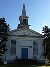 | October 9, 1980 (#80001885) | Northeast of Clarkston at 5331 Maybee Rd. 42°43′09″N83°21′44″W / 42.719167°N 83.362222°W | Clarkston | Built in 1856 for the First Presbyterian of Independence Township. The congregation dissolved in 1932, and in 1946, the Sashabaw United Presbyterian Church was organized and began using this building as its home. |
| 69 | William Edmund and Nina A. Downey Scripps Estate |  | September 27, 2007 (#07001009) | 1840 Scripps Rd. 42°44′58″N83°17′01″W / 42.74945°N 83.283672°W | Lake Orion | Also called the Scripps Mansion or Moulton Manor. Tudor Revival mansion built by William Edmund Scripps for his family in 1927; now serves as a Catholic Guest House and Retreat Center. |
| 70 | Melvyn Maxwell and Sara Stein Smith House |  | March 28, 1997 (#97000283) | 5045 Ponvalley Rd., Bloomfield Township 42°33′54″N83°16′16″W / 42.565°N 83.271111°W | Pontiac | Also known as Myhaven. Frank Lloyd Wright-designed Usonian home that was constructed in 1949 and 1950. The owners were two public school teachers living on a tight budget. The 1957 landscape design is by Thomas Dolliver Church. |
| 71 | Rollin Sprague Building-Old Stone Store |  | April 22, 1999 (#99000474) | 300 Main St. 42°40′46″N83°08′00″W / 42.679444°N 83.133333°W | Rochester | |
| 72 | St. Vincent DePaul Catholic Church, Convent, and School | 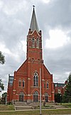 | June 9, 1989 (#89000492) | 150 E. Wide Track Dr. 42°37′56″N83°17′14″W / 42.632222°N 83.287222°W | Pontiac | The St. Vincent de Paul Church was built in 1885. In 1999, the diocese merged the St. Vincent de Paul parish with two other local parishes (St. Joseph and St. Michael the Archangel) to form the St Damien of Molokai parish. |
| 73 | Stony Creek Village Historic District |  | June 26, 1972 (#72000649) | Northeast of Rochester on Washington Rd. 42°41′48″N83°06′49″W / 42.696667°N 83.113611°W | Rochester | |
| 74 | Thomas W. and Margaret Taliaferro House |  | September 15, 2011 (#11000668) | 1115 Eton Cross 42°34′35″N83°13′51″W / 42.576389°N 83.230833°W | Bloomfield Hills | |
| 75 | Charles Torrey House |  | May 21, 1992 (#92000585) | 1141 Foxwood Ct. 42°36′58″N83°13′23″W / 42.616111°N 83.223056°W | Bloomfield Township | |
| 76 | Walbri Hall |  | January 6, 2022 (#100007209) | 3570 Walbri Dr. 42°35′20″N83°13′24″W / 42.588889°N 83.223333°W | Bloomfield Hills | |
| 77 | Waterford Village Historic District |  | August 10, 1979 (#79001167) | Dubay Street, Pontiff Street, Steffens Street, Andersonville Road and Airport Road. 42°42′00″N83°24′20″W / 42.7°N 83.405556°W | Waterford Township | |
| 78 | Elmer R. Webster School | 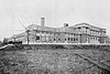 | May 9, 2022 (#100007710) | 640 West Huron St. 42°38′10″N83°18′58″W / 42.636111°N 83.316111°W | Pontiac | |
| 79 | Western Knitting Mills |  | June 9, 2000 (#00000646) | 400 Water St. 42°40′49″N83°07′52″W / 42.680278°N 83.131111°W | Rochester | |
| 80 | Wisner House |  | July 8, 1970 (#70000284) | 405 Cesar Chavez Ave. 42°38′54″N83°18′17″W / 42.648333°N 83.304722°W | Pontiac | |
| 81 | Minoru and Teruko (Hirashiki) Yamasaki House | 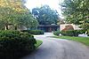 | December 11, 2013 (#13000905) | 3717 Lakecrest Drive 42°35′14″N83°13′33″W / 42.587146°N 83.225831°W | Bloomfield Hills | The home of architect Minoru Yamasaki, designed by him in 1972. |
| 82 | Joseph D. Yerkes House |  | January 26, 1984 (#84001822) | 42580 Eight Mile Rd. 42°26′18″N83°27′53″W / 42.438333°N 83.464722°W | Novi | The original Joseph Yerkes House burned in 1989. [8] |
| 83 | Robert Yerkes House |  | November 30, 1973 (#73000955) | 535 E. Base Line Rd. 42°26′17″N83°28′35″W / 42.438056°N 83.476389°W | Northville |