This is a list of sites in Minnesota which are included in the National Register of Historic Places. There are more than 1,700 properties and historic districts listed on the NRHP; each of Minnesota's 87 counties has at least 2 listings. Twenty-two sites are also National Historic Landmarks.

This is a list of the National Register of Historic Places listings in Blue Earth County, Minnesota. It is intended to be a complete list of the properties and districts on the National Register of Historic Places in Blue Earth County, Minnesota, United States. The locations of National Register properties and districts for which the latitude and longitude coordinates are included below, may be seen in an online map.
This is a list of the National Register of Historic Places listings in Brown County, Minnesota. It is intended to be a complete list of the properties and districts on the National Register of Historic Places in Brown County, Minnesota, United States. The locations of National Register properties and districts for which the latitude and longitude coordinates are included below, may be seen in an online map.

This is a list of the National Register of Historic Places listings in Crow Wing County, Minnesota. It is intended to be a complete list of the properties and districts on the National Register of Historic Places in Crow Wing County, Minnesota, United States. The locations of National Register properties and districts for which the latitude and longitude coordinates are included below, may be seen in an online map.

This is a list of the National Register of Historic Places listings in Olmsted County, Minnesota. It is intended to be a complete list of the properties and districts on the National Register of Historic Places in Olmsted County, Minnesota, United States. The locations of National Register properties and districts for which the latitude and longitude coordinates are included below, may be seen in an online map.
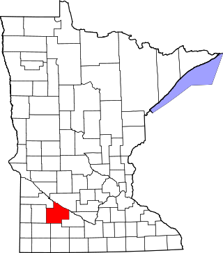
This is a list of the National Register of Historic Places listings in Redwood County, Minnesota. It is intended to be a complete list of the properties and districts on the National Register of Historic Places in Redwood County, Minnesota, United States. The locations of National Register properties and districts for which the latitude and longitude coordinates are included below, may be seen in an online map.

This is a list of the National Register of Historic Places listings in Chisago County, Minnesota. It is intended to be a complete list of the properties and districts on the National Register of Historic Places in Chisago County, Minnesota, United States. The locations of National Register properties and districts for which the latitude and longitude coordinates are included below, may be seen in an online map.

This is a list of the National Register of Historic Places listings in Winona County, Minnesota. It is intended to be a complete list of the properties and districts on the National Register of Historic Places in Winona County, Minnesota, United States. The locations of National Register properties and districts for which the latitude and longitude coordinates are included below, may be seen in an online map.

This is a list of the National Register of Historic Places listings in Fillmore County, Minnesota. It is intended to be a complete list of the properties and districts on the National Register of Historic Places in Fillmore County, Minnesota, United States. The locations of National Register properties and districts for which the latitude and longitude coordinates are included below, may be seen in an online map.

This is a list of the National Register of Historic Places listings in Le Sueur County, Minnesota. It is intended to be a complete list of the properties and districts on the National Register of Historic Places in Le Sueur County, Minnesota, United States. The locations of National Register properties and districts for which the latitude and longitude coordinates are included below, may be seen in an online map.

This is a list of the National Register of Historic Places listings in Cook County, Minnesota. It is intended to be a complete list of the properties and districts on the National Register of Historic Places in Cook County, Minnesota, United States. The locations of National Register properties and districts for which the latitude and longitude coordinates are included below, may be seen in an online map.
This is a list of the National Register of Historic Places listings in Koochiching County, Minnesota. It is intended to be a complete list of the properties and districts on the National Register of Historic Places in Koochiching County, Minnesota, United States. The locations of National Register properties and districts for which the latitude and longitude coordinates are included below, may be seen in an online map.

This is a list of the National Register of Historic Places listings in Kandiyohi County, Minnesota. It is intended to be a complete list of the properties and districts on the National Register of Historic Places in Kandiyohi County, Minnesota, United States. The locations of National Register properties and districts for which the latitude and longitude coordinates are included below, may be seen in an online map.

This is a list of the National Register of Historic Places listings in Martin County, Minnesota. It is intended to be a complete list of the properties and districts on the National Register of Historic Places in Martin County, Minnesota, United States. The locations of National Register properties and districts for which the latitude and longitude coordinates are included below, may be seen in an online map.

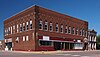
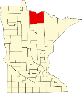
The Fremad Association Building and adjacent Pope County State Bank Building are historic commercial properties in Glenwood, Minnesota.

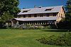
The Pope County Courthouse is the courthouse and government center of Pope County, Minnesota, United States, in the city of Glenwood. It was built in 1930 as a replacement for a prior courthouse on the same site dating to 1879. The current courthouse is listed on the National Register of Historic Places for having local significance in politics/government and architecture. Its historic significance derives from being the long-serving seat of Pope County government and for being a well-preserved example of the replacement courthouses built in a few Minnesota counties in the 1930s.

Glenwood Public Library is the public library serving the city and surrounding area of Glenwood, Minnesota, United States. The original wing of the building was constructed in 1908 as a Carnegie library and was listed on the National Register of Historic Places in 1982 for its local significance in architecture and education. It was nominated to the National Register for being one of Pope County's most architecturally distinctive buildings and its only representative of the Carnegie library phenomenon.

The Urjans Iverson House is a historic log cabin in Gilchrist Township, Minnesota, United States, built in 1866. It was restored in 1990 and is preserved within Fort Lake Johanna Roadside Park off Minnesota State Highway 104. The cabin was listed on the National Register of Historic Places in 1982 for its local significance in the theme of exploration/settlement. It was nominated for its broad associations with the early settlement of Pope County.

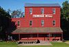
The Terrace Mill is a historic watermill in Terrace, Minnesota, United States, now operated as a museum. Managed by the non-profit Terrace Mill Foundation, the mill contains a gallery, theatre, and gift shop, while the grounds host outdoor events. The mill and four associated structures are listed on the National Register of Historic Places as the Terrace Mill Historic District for having local significance in commerce, engineering, industry, and transportation.

Terrace is an unincorporated community in Chippewa Falls Township, Pope County, Minnesota, United States. The community was settled in the 1870s around the Terrace Mill. In 1982, a historic district of early buildings and structures was listed on the National Register of Historic Places as the Terrace Historic District for having local significance under the themes of exploration/settlement and industry. It was nominated as a well-preserved example of the small communities that grew up around Minnesota's rural mills in the latter 19th century.