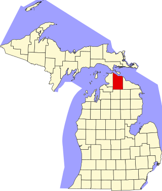
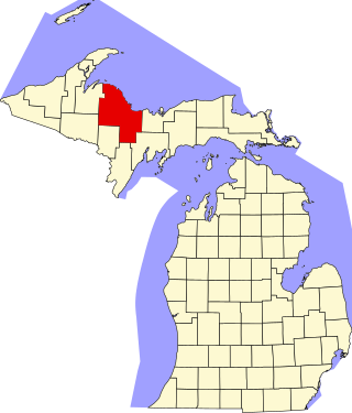
This is intended to be a complete list of the properties and districts on the National Register of Historic Places in Presque Isle County, Michigan, United States. Latitude and longitude coordinates are provided for many National Register properties and districts; these locations may be seen together in a map.[1]
There are 15 properties and districts listed on the National Register in the county.
A former Civilian Conservation Corps camp, this property is now known as the Ocqueoc Outdoor Center, and is used for youth and adult outdoor activities. It is significant as one of only two surviving CCC camps in Michigan, out of the 122 different original camp locations.
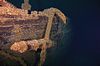
The Choctaw was a semi-whaleback ship (one of three built) that sank on Lake Huron in 1915 following a collision with the Canadian package freighter Wahcondah.
The F.T. Barney was a schooner built in 1856. It sank in 1868 in a collision with another schooner; the wreck lay undiscovered until 1987. It is in 160 feet of water, and is one of the most complete of a schooner of its era.
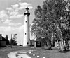
In the mid-1800s, as lights were built along the coasts of the Great Lakes, the New Presque Isle Light's range of visibility of 19 miles (31km) and the Cheboygan Crib Light's visible range of 13 miles (21km) left an unlighted 18-mile (29km) intervening stretch of coastline along which mariners had to navigate blind. In 1895, money was appropriated to build this light, 40 miles (64km) south of Mackinac Point. The plan for this light is nearly identical to the one for the Big Bay Point Lighthouse on Lake Superior that was constructed at the same time.
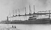
The Norman was built in 1890 by the Globe Iron Works in Cleveland, Ohio. She was one of the first propeller-driven steel lakers that hauled iron and coal on the Great Lakes. On May 30, 1895, the Norman and the steamer Jack collided in the fog. She currently lies in 210 feet of water.
Hoeft State Park is built on land donated in 1922 by lumber baron Paul H. Hoeft. The heavily wooded park sits on 1-mile (1.6km) of Lake Huron shoreline and offers 143 campsites along with 4 miles (6.4km) of hiking trails, hunting, play grounds, a picnic pavilion and a lodge erected in the late 1930s by the Civilian Conservation Corps.
The Ocqueoc Falls Highway–Ocqueoc River Bridge, built in 1920, is significant as a well-preserved early example of concrete arch bridges constructed by the Michigan State Highway Department.
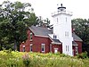
The Old Presque Isle Light was the first lighthouse in the Presque Isle, Michigan area. The light was built in 1840, and was constructed of two-thirds stone and one-third brick. However, the tower and dwelling did not last long in the harsh weather, however, and by 1867 they were deteriorated enough for Congress to find need for a newer station. The New Presque Isle Light was constructed in 1870, and the Old Presque Isle Light was deactivated in 1871. The old light currently serves as a museum.
One of the oldest state parks in Michigan, Onaway State Park was dedicated in 1921. Located on Black Lake, it contains sand cobblestone beaches, large rock outcroppings, a campground, and a nature trail highlighting a diversity of trees.
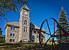
This building, also known as the Onaway Courthouse, was constructed in 1908 by Merritt Chandler in an effort to wrest the county seat away from Rogers City. Although he was unsuccessful, as a compromise county court sessions were alternated between Rogers City and Onaway until the 1940s. The building now houses a public library, Historical Museum, the Chamber of Commerce, and offices of the City of Onaway.
The New Presque Isle Light was built in 1870 to replace the deteriorating Old Presque Isle Light. U.S. Army Corps of Engineers Major Orlando M. Poe designed the light, with a tapered tower and connected keeper's quarters. The design was so elegant that several other lighthouses around the Great Lakes were built to similar specifications.
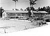
The Presque Isle Lodge is a 10,000 square foot Rustic log structure, constructed in 1920. Currently operating as a bed and breakfast, it contains a large collection of original rustic log furniture.
The Radka–Bradley House, also known as just the Bradley House was for 13 years the home of Carl D. Bradley, who propelled the Michigan Limestone and Chemical Company to national prominence. After Bradley's death, his successors as Michigan Limestone's CEO lived in the house; it now serves as the Presque Isle County Historical Museum.
This is a list of the National Register of Historic Places listings in Alger County, Michigan.
This is a list of the National Register of Historic Places listings in Berrien County, Michigan.
This is a list of the National Register of Historic Places listings in Cheboygan County, Michigan.
This is a list of the National Register of Historic Places listings in Chippewa County, Michigan.
This is a list of the National Register of Historic Places listings in Emmet County, Michigan.
This is a list of the National Register of Historic Places listings in Ingham County, Michigan.
This is a list of the National Register of Historic Places listings in Leelanau County, Michigan.
This is a list of the National Register of Historic Places listings in Jackson County, Michigan.
This is a list of the National Register of Historic Places listings in Menominee County, Michigan.
This is a list of the National Register of Historic Places listings in Manistee County, Michigan.
There are 40 properties or districts on the National Register of Historic Places in Marquette County in the US state of Michigan. The locations of National Register properties and districts in Marquette County for which the latitude and longitude coordinates are included below, may be seen in a map.
This is a list of the National Register of Historic Places listings in Mackinac County, Michigan.
This is a list of the National Register of Historic Places listings in Sanilac County, Michigan.
This is a list of the National Register of Historic Places listings in St. Joseph County, Michigan.
This is a list of the National Register of Historic Places listings in Erie County, Ohio.
This is a list of the National Register of Historic Places listings in Duval County, Florida.
This is a list of the National Register of Historic Places listings in Isle of Wight County, Virginia.
This is a list of the National Register of Historic Places listings in Gogebic County, Michigan.
This is a list of the National Register of Historic Places listings in Gratiot County, Michigan.
This is a list of the National Register of Historic Places listings in Isle Royale National Park.
References
↑ The latitude and longitude information provided in this table was derived originally from the National Register Information System, which has been found to be fairly accurate for about 99% of listings. Some locations in this table may have been corrected to current GPS standards.
↑ Numbers represent an alphabetical ordering by significant words. Various colorings, defined here, differentiate National Historic Landmarks and historic districts from other NRHP buildings, structures, sites or objects.
↑ The eight-digit number below each date is the number assigned to each location in the National Register Information System database, which can be viewed by clicking the number.
↑ The location of the F. T. Barney Shipwreck is given in the NRIS as "address restricted." However, the Thunder Bay National Marine Sanctuary gives the geo-coordinates listed
This page is based on this Wikipedia article Text is available under the CC BY-SA 4.0 license; additional terms may apply. Images, videos and audio are available under their respective licenses.