National Register of Historic Places listings in Redwood County, Minnesota

Last updated
Location of Redwood County in Minnesota Map of Minnesota highlighting Redwood County.svg
Location of Redwood County in Minnesota

This is a list of the National Register of Historic Places listings in Redwood County, Minnesota. It is intended to be a complete list of the properties and districts on the National Register of Historic Places in Redwood County, Minnesota, United States. The locations of National Register properties and districts for which the latitude and longitude coordinates are included below, may be seen in an online map.

Contents

There are 22 properties and districts listed on the National Register in the county. A supplementary list includes four additional sites that were formerly on the National Register.

This National Park Service list is complete through NPS recent listings posted December 30, 2021. [1]

Current listings

Map all coordinates using: OpenStreetMap  
Download coordinates as: KML
[2] Name on the RegisterImageDate listed [3] Location City or townDescription
1 J.A. Anderson House
J.A. Anderson House JAAndersonHouse.jpg
J.A. Anderson House
August 11, 1980
(#80002132)
402 4th Ave.
44°13′44″N95°16′06″W / 44.228817°N 95.26825°W / 44.228817; -95.26825 (J.A. Anderson House)
Lamberton Redwood County's most prominent example of a Queen Anne house, built circa 1900. [4]
2 Bank of Redwood Falls Building
Bank of Redwood Falls Building Bank of Redwood Falls.jpg
Bank of Redwood Falls Building
August 11, 1980
(#80002141)
105 E. 2nd St.
44°32′26″N95°07′09″W / 44.540588°N 95.119146°W / 44.540588; -95.119146 (Bank of Redwood Falls Building)
Redwood Falls Small bank building constructed circa 1885, significant for the integrity of its outsized Richardsonian Romanesque features on the Redwood Falls streetscape. [5]
3 Birch Coulee School
Birch Coulee School Birch Coulee School.jpg
Birch Coulee School
April 12, 1990
(#90000554)
Off County Highway 2, south of Morton
44°32′01″N94°59′49″W / 44.533529°N 94.996982°W / 44.533529; -94.996982 (Birch Coulee School)
Morton vicinitySchoolhouse active 1891–1920 on the Lower Sioux Indian Reservation, a reminder of federal efforts at cultural assimilation of Native Americans through formal education. The earliest and best preserved of Minnesota's surviving Native American education facilities. [6]
4 Chicago and North Western Railroad Depot
Chicago and North Western Railroad Depot LucanDepot.jpg
Chicago and North Western Railroad Depot
August 11, 1980
(#80002135)
1st St.
44°24′39″N95°24′35″W / 44.410788°N 95.409712°W / 44.410788; -95.409712 (Chicago and North Western Railroad Depot)
Lucan 1902 railway station symbolizing the key role of railroads in the area's agricultural development and the siting of its towns. [7]
5 H.D. Chollar House
H.D. Chollar House H.D. Chollar House.jpg
H.D. Chollar House
August 11, 1980
(#80002142)
4th and Minnesota Sts.
44°32′20″N95°07′15″W / 44.538921°N 95.120788°W / 44.538921; -95.120788 (H.D. Chollar House)
Redwood Falls Redwood Falls' only Italianate house, built c. 1878. Also noted for its owner's association with the local railside lumber yard, an important early business in most area towns. [8]
6 City Blacksmith Shop
City Blacksmith Shop Lambertonbss.jpg
City Blacksmith Shop
August 11, 1980
(#80002133)
Douglas St. and 2nd Ave.
44°13′51″N95°15′55″W / 44.23085°N 95.265348°W / 44.23085; -95.265348 (City Blacksmith Shop)
Lamberton c. 1898 blacksmith shop with much of its original equipment, a leading example of a key service in many of the area's communities catering to the agricultural sector. [9] Now managed by the Lamberton Area Historical Society. [10]
7 Clements State Bank Building
Clements State Bank Building ClementsMNStateBank.jpg
Clements State Bank Building
August 11, 1980
(#80002130)
1st and Pine Sts.
44°22′50″N95°03′11″W / 44.380546°N 95.053164°W / 44.380546; -95.053164 (Clements State Bank Building)
Clements 1902 bank building—founded, like the Milroy State Bank Building, by businessmen from Springfield, Minnesota—representing the commercial investment of outsiders in a string of towns platted on a new railroad line. [11]
8 District No. 8 School
District No. 8 School DistrictNo8.jpeg
District No. 8 School
August 11, 1980
(#80002131)
County Road 70
44°23′24″N95°09′06″W / 44.389942°N 95.151654°W / 44.389942; -95.151654 (District No. 8 School)
Clements vicinity1908 example of Redwood County's rural schoolhouses, particularly notable for the retention of its original outbuildings (a barn and outhouse). [12]
9 Gilfillan
Gilfillan Gilfillan Estate.jpg
Gilfillan
August 11, 1980
(#80002143)
Minnesota Highway 67
44°27′46″N94°59′40″W / 44.462823°N 94.994434°W / 44.462823; -94.994434 (Gilfillan)
Redwood Falls vicinity1882 farm of Charles Duncan Gilfillan (1831–1902) and his son (1872–1962), significant for their role in developing St. Paul and Redwood County, and their promotion of progressive farming in southwest Minnesota. The large farmstead is also associated with the alienation of seized Dakota reservation land. [13] Now managed by the Redwood County Historical Society. [14]
10 Gimmestad Land and Loan Office
Gimmestad Land and Loan Office Gimmestad Land and Loan Office.jpg
Gimmestad Land and Loan Office
August 11, 1980
(#80002128)
Main St.
44°36′21″N95°19′47″W / 44.605855°N 95.329753°W / 44.605855; -95.329753 (Gimmestad Land and Loan Office)
Belview Rare intact example of an early office building—built in 1892—and a representative of the once-common land and loan offices that promoted small town commerce. [15]
11 Honner-Hosken House
Honner-Hosken House Honner-Hosken House.jpg
Honner-Hosken House
August 11, 1980
(#80002138)
North and Main Sts.
44°33′52″N95°05′41″W / 44.564434°N 95.094652°W / 44.564434; -95.094652 (Honner-Hosken House)
North Redwood 1872 home of notable settler J.S.G. Honner (d. 1888) and later Thomas Hosken (d. 1929), Honner's successor in a locally important quarrying operation. [16]
12 Lower Sioux Agency
Lower Sioux Agency Lower Sioux Agency warehouse.jpg
Lower Sioux Agency
September 22, 1970
(#70000308)
32469 County Road 2 [17]
44°31′34″N94°57′28″W / 44.52616°N 94.957838°W / 44.52616; -94.957838 (Lower Sioux Agency)
Morton Site of the 1853 federal administrative center for the Lower Sioux Indian Reservation, destroyed at the outbreak of the Dakota War of 1862. [18] Now a state/tribal museum containing a restored 1861 stone warehouse. [19]
13 Milroy State Bank Building
Milroy State Bank Building Milroy State Bank.jpg
Milroy State Bank Building
August 11, 1980
(#80002137)
Superior St. and Euclid Ave.
44°25′08″N95°33′14″W / 44.418877°N 95.553795°W / 44.418877; -95.553795 (Milroy State Bank Building)
Milroy 1902 bank building—founded, like the Clements State Bank Building, by businessmen from Springfield, Minnesota—representing the commercial investment of outsiders in a string of towns platted on a new railroad line. [20]
14 Minneapolis and St. Louis Railroad Depot
Minneapolis and St. Louis Railroad Depot Belview Depot.jpg
Minneapolis and St. Louis Railroad Depot
August 11, 1980
(#80002129)
Off Main St.
44°36′26″N95°19′48″W / 44.607236°N 95.329978°W / 44.607236; -95.329978 (Minneapolis and St. Louis Railroad Depot)
Belview 1892 railway station symbolizing the key role of railroads in the area's agricultural development and the siting of its towns. [21]
15 Odeon Theater
Odeon Theater Belview Odeon.jpg
Odeon Theater
August 30, 1974
(#74001041)
Main St.
44°36′16″N95°19′45″W / 44.604558°N 95.329209°W / 44.604558; -95.329209 (Odeon Theater)
Belview Well-preserved example of a rural theater hall, built in 1901, with simplified Queen Anne architecture. [22]
16 Ramsey Park Swayback Bridge
Ramsey Park Swayback Bridge RamseySwaybackBridge.jpg
Ramsey Park Swayback Bridge
August 11, 1980
(#80002144)
Ramsey Park
44°33′03″N95°07′30″W / 44.55088°N 95.124961°W / 44.55088; -95.124961 (Ramsey Park Swayback Bridge)
Redwood Falls Unique park bridge built by the Works Progress Administration in 1938. [23]
17 Redwood Falls Carnegie Library
Redwood Falls Carnegie Library Redwood Falls Carnegie Library.jpg
Redwood Falls Carnegie Library
August 11, 1980
(#80002139)
334 S. Jefferson St.
44°32′20″N95°07′00″W / 44.538957°N 95.116609°W / 44.538957; -95.116609 (Redwood Falls Carnegie Library)
Redwood Falls 1904 Carnegie library, significant for having the most intact exterior of Redwood County's early educational buildings. [24]
18 Redwood Falls Retaining Wall Roadside Development Project
Redwood Falls Retaining Wall Roadside Development Project Redwood Falls Retaining Wall.jpg
Redwood Falls Retaining Wall Roadside Development Project
July 25, 2012
(#12000429)
Junction of MN 19 & US 71
44°32′28″N95°07′13″W / 44.541054°N 95.120342°W / 44.541054; -95.120342 (Redwood Falls Retaining Wall Roadside Development Project)
Redwood Falls Exemplary early roadside development built 1934–36 by the Minnesota Department of Highways to increase safety and aesthetics along the developing state highway system. [25]
19 Revere Fire Hall
Revere Fire Hall RevereFireHall.jpg
Revere Fire Hall
August 11, 1980
(#80002145)
2nd St.
44°13′21″N95°21′55″W / 44.222504°N 95.365384°W / 44.222504; -95.365384 (Revere Fire Hall)
Revere Fire station built c. 1900, representative of common, specialized municipal buildings. [26]
20 St. Cornelia's Episcopal Church
St. Cornelia's Episcopal Church StCorneliasMorton.jpg
St. Cornelia's Episcopal Church
October 11, 1979
(#79003717)
38378 Reservation Hwy 101
44°32′00″N94°59′43″W / 44.533449°N 94.995314°W / 44.533449; -94.995314 (St. Cornelia's Episcopal Church)
Morton vicinityChurch built 1889–91 for a returning Dakota congregation after years of exile from Minnesota following the Dakota War of 1862. Also an example of the Episcopal missionary work among Native Americans and fine Gothic Revival church construction under Bishop Henry Benjamin Whipple. [27]
21 Scenic City Cooperative Oil Company
Scenic City Cooperative Oil Company ScenicCityCoop.jpg
Scenic City Cooperative Oil Company
August 11, 1980
(#80002140)
2nd and Mill Sts.
44°32′25″N95°07′09″W / 44.54032°N 95.119216°W / 44.54032; -95.119216 (Scenic City Cooperative Oil Company)
Redwood Falls Distinctive service station built c. 1925, dating to the advent of widespread automobile use in Redwood County. [28]
22 Walnut Grove Creamery Association
Walnut Grove Creamery Association WalnutGroveCreamery.jpg
Walnut Grove Creamery Association
July 12, 2006
(#06000602)
521 Main St.
44°13′22″N95°28′09″W / 44.222821°N 95.469044°W / 44.222821; -95.469044 (Walnut Grove Creamery Association)
Walnut Grove 1930 cooperative milk-processing facility, a well-preserved example of the small early-20th-century creameries serving the region's dairy farming industry. [29]

Former listings

[2] Name on the RegisterImageDate listedDate removedLocationCity or townDescription
1 Commercial Hotel
Commercial Hotel 1914postMainStreetWabassoMN.jpg
Commercial Hotel
August 11, 1980
(#80002146)
January 31, 2019Front and Main Sts.
Wabasso 1901 example of a privately funded, frame hotel serving a small-town railroad junction. [30] Demolished circa 2010.
2 Delhi Coronet Band Hall May 17, 1984
(#84001687)
November 1, 20183rd St.
Delhi 1896 community band hall significant as the venue for many political and social events in Delhi Township's development. [31] Demolished in 2007. [32]
3 Lamberton Farmers Elevator August 11, 1980
(#80002134)
February 13, 19911st Ave. and Douglas St.
Lamberton Unusual brick grain elevator built in 1916. Fell into disrepair and demolished by the city in 1989. [33]
4 Milroy Block August 11, 1980
(#80002136)
August 2, 2000Euclid Ave. and Cherry St.
Milroy 1902 Italianate commercial building. [34] Demolished in 1998. [35]

See also

Related Research Articles

National Register of Historic Places listings in Minnesota

This is a list of sites in Minnesota which are included in the National Register of Historic Places. There are more than 1,700 properties and historic districts listed on the NRHP; each of Minnesota's 87 counties has at least 2 listings. Twenty-two sites are also National Historic Landmarks.

National Register of Historic Places listings in Hennepin County, Minnesota

This list is of the properties and historic districts which are designated on the National Register of Historic Places or that were formerly so designated, in Hennepin County, Minnesota; there are 183 entries as of October 2021. A significant number of these properties are a result of the establishment of Fort Snelling, the development of water power at Saint Anthony Falls, and the thriving city of Minneapolis that developed around the falls. Many historic sites outside the Minneapolis city limits are associated with pioneers who established missions, farms, and schools in areas that are now suburbs in that metropolitan area.

National Register of Historic Places listings in Rice County, Minnesota

This is a list of the National Register of Historic Places listings in Rice County, Minnesota. It is intended to be a complete list of the properties and districts on the National Register of Historic Places in Rice County, Minnesota, United States. The locations of National Register properties and districts for which the latitude and longitude coordinates are included below, may be seen in an online map.

National Register of Historic Places listings in Carver County, Minnesota

This is a list of the National Register of Historic Places listings in Carver County, Minnesota. It is intended to be a complete list of the properties and districts on the National Register of Historic Places in Carver County, Minnesota, United States. The locations of National Register properties and districts for which the latitude and longitude coordinates are included below, may be seen in an online map.

National Register of Historic Places listings in Goodhue County, Minnesota

This is a list of the National Register of Historic Places listings in Goodhue County, Minnesota. It is intended to be a complete list of the properties and districts on the National Register of Historic Places in Goodhue County, Minnesota, United States. The locations of National Register properties and districts for which the latitude and longitude coordinates are included below, may be seen in an online map.

National Register of Historic Places listings in Blue Earth County, Minnesota

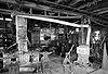
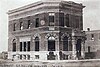
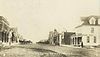
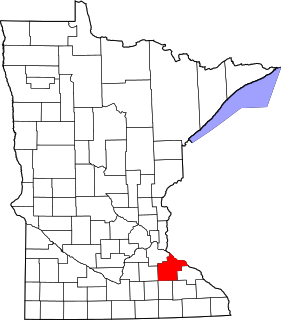
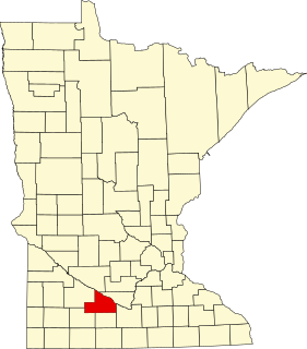
This is a list of the National Register of Historic Places listings in Blue Earth County, Minnesota. It is intended to be a complete list of the properties and districts on the National Register of Historic Places in Blue Earth County, Minnesota, United States. The locations of National Register properties and districts for which the latitude and longitude coordinates are included below, may be seen in an online map.

National Register of Historic Places listings in Brown County, Minnesota

This is a list of the National Register of Historic Places listings in Brown County, Minnesota. It is intended to be a complete list of the properties and districts on the National Register of Historic Places in Brown County, Minnesota, United States. The locations of National Register properties and districts for which the latitude and longitude coordinates are included below, may be seen in an online map.

National Register of Historic Places listings in Morrison County, Minnesota

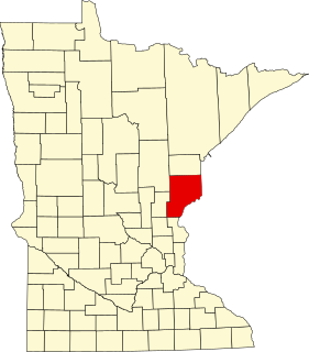
This is a list of the National Register of Historic Places listings in Morrison County, Minnesota. It is intended to be a complete list of the properties and districts on the National Register of Historic Places in Morrison County, Minnesota, United States. The locations of National Register properties and districts for which the latitude and longitude coordinates are included below, may be seen in an online map.

National Register of Historic Places listings in Otter Tail County, Minnesota

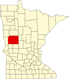
This is a list of the National Register of Historic Places listings in Otter Tail County, Minnesota. It is intended to be a complete list of the properties and districts on the National Register of Historic Places in Otter Tail County, Minnesota, United States. The locations of National Register properties and districts for which the latitude and longitude coordinates are included below, may be seen in an online map.

National Register of Historic Places listings in Pine County, Minnesota

This is a list of the National Register of Historic Places listings in Pine County, Minnesota. It is intended to be a complete list of the properties and districts on the National Register of Historic Places in Pine County, Minnesota, United States. The locations of National Register properties and districts for which the latitude and longitude coordinates are included below, may be seen in an online map.

National Register of Historic Places listings in Winona County, Minnesota

This is a list of the National Register of Historic Places listings in Winona County, Minnesota. It is intended to be a complete list of the properties and districts on the National Register of Historic Places in Winona County, Minnesota, United States. The locations of National Register properties and districts for which the latitude and longitude coordinates are included below, may be seen in an online map.

National Register of Historic Places listings in Le Sueur County, Minnesota

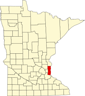
This is a list of the National Register of Historic Places listings in Le Sueur County, Minnesota. It is intended to be a complete list of the properties and districts on the National Register of Historic Places in Le Sueur County, Minnesota, United States. The locations of National Register properties and districts for which the latitude and longitude coordinates are included below, may be seen in an online map.

National Register of Historic Places listings in Washington County, Minnesota

This is a list of the National Register of Historic Places listings in Washington County, Minnesota. It is intended to be a complete list of the properties and districts on the National Register of Historic Places in Washington County, Minnesota, United States. The locations of National Register properties and districts for which the latitude and longitude coordinates are included below, may be seen in an online map.

National Register of Historic Places listings in Wright County, Minnesota

This is a list of the National Register of Historic Places listings in Wright County, Minnesota. It is intended to be a complete list of the properties and districts on the National Register of Historic Places in Wright County, Minnesota, United States. The locations of National Register properties and districts for which the latitude and longitude coordinates are included below, may be seen in an online map.

National Register of Historic Places listings in Cook County, Minnesota

This is a list of the National Register of Historic Places listings in Cook County, Minnesota. It is intended to be a complete list of the properties and districts on the National Register of Historic Places in Cook County, Minnesota, United States. The locations of National Register properties and districts for which the latitude and longitude coordinates are included below, may be seen in an online map.

National Register of Historic Places listings in Pope County, Minnesota

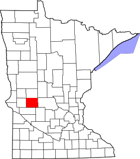
This is a list of the National Register of Historic Places listings in Pope County, Minnesota. It is intended to be a complete list of the properties and districts on the National Register of Historic Places in Pope County, Minnesota, United States. The locations of National Register properties and districts for which the latitude and longitude coordinates are included below, may be seen in an online map.

National Register of Historic Places listings in Koochiching County, Minnesota

This is a list of the National Register of Historic Places listings in Koochiching County, Minnesota. It is intended to be a complete list of the properties and districts on the National Register of Historic Places in Koochiching County, Minnesota, United States. The locations of National Register properties and districts for which the latitude and longitude coordinates are included below, may be seen in an online map.

National Register of Historic Places listings in Kandiyohi County, Minnesota

This is a list of the National Register of Historic Places listings in Kandiyohi County, Minnesota. It is intended to be a complete list of the properties and districts on the National Register of Historic Places in Kandiyohi County, Minnesota, United States. The locations of National Register properties and districts for which the latitude and longitude coordinates are included below, may be seen in an online map.

National Register of Historic Places listings in Martin County, Minnesota

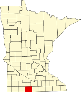
This is a list of the National Register of Historic Places listings in Martin County, Minnesota. It is intended to be a complete list of the properties and districts on the National Register of Historic Places in Martin County, Minnesota, United States. The locations of National Register properties and districts for which the latitude and longitude coordinates are included below, may be seen in an online map.

References

  1. National Park Service, United States Department of the Interior, "National Register of Historic Places: Weekly List Actions", retrieved December 30, 2021.
  2. 1 2 Numbers represent an alphabetical ordering by significant words. Various colorings, defined here, differentiate National Historic Landmarks and historic districts from other NRHP buildings, structures, sites or objects.
  3. The eight-digit number below each date is the number assigned to each location in the National Register Information System database, which can be viewed by clicking the number.
  4. Gimmestad, Dennis A. (September 1978). "Minnesota Historic Properties Inventory Form: Anderson, J. A., House" (PDF). National Park Service. Retrieved 2013-10-01.Cite journal requires |journal= (help)
  5. Gimmestad, Dennis A. (September 1978). "Minnesota Historic Properties Inventory Form: Bank of Redwood Falls Building" (PDF). National Park Service. Retrieved 2013-10-01.Cite journal requires |journal= (help)
  6. Koop, Michael (February 1989). "National Register of Historic Places Registration Form: Birch Coulee School" (PDF). National Park Service. Retrieved 2013-10-01.Cite journal requires |journal= (help)
  7. Gimmestad, Dennis A. (September 1978). "Chicago & North Western Railroad Depot" (PDF). National Park Service. Retrieved 2013-10-01.Cite journal requires |journal= (help)
  8. Gimmestad, Dennis A. (September 1978). "Minnesota Historic Properties Inventory Form: Chollar, H. D., House" (PDF). National Park Service. Retrieved 2013-10-01.Cite journal requires |journal= (help)
  9. Gimmestad, Dennis A. (September 1978). "Minnesota Historic Properties Inventory Form: City Blacksmith Shop" (PDF). National Park Service. Retrieved 2013-10-01.Cite journal requires |journal= (help)
  10. Hagedon, Emily. "Hanzlik Blacksmith Shop" . Retrieved 2012-08-29.
  11. Gimmestad, Dennis A. (September 1978). "Clements State Bank Building" (PDF). National Park Service. Retrieved 2013-09-03.Cite journal requires |journal= (help)
  12. Gimmestad, Dennis A. (September 1978). "School District #8" (PDF). National Park Service. Retrieved 2013-10-01.Cite journal requires |journal= (help)
  13. Gimmestad, Dennis A. (September 1978). "Gilfillan" (PDF). National Park Service. Retrieved 2013-10-01.Cite journal requires |journal= (help)
  14. "Gilfillan Estate". Redwood County Historical Society. Retrieved 2013-10-01.
  15. Gimmestad, Dennis A. (September 1978). "Gimmestad Land and Loan Office" (PDF). National Park Service. Retrieved 2013-09-13.Cite journal requires |journal= (help)
  16. Gimmestad, Dennis A. (September 1978). "Honnor-Hosken House" (PDF). National Park Service. Retrieved 2013-09-13.Cite journal requires |journal= (help)
  17. Address derived from "Lower Sioux Agency". Minnesota Historical Society. Retrieved 2012-08-29. NRIS database lists site as "Address restricted."
  18. Grossman, John (1970-03-23). "National Register of Historic Places Inventory – Nomination Form: Lower Sioux Agency". National Park Service.Cite journal requires |journal= (help)
  19. "Lower Sioux Agency". Minnesota Historical Society. Retrieved 2012-08-29.
  20. Gimmestad, Dennis A. (September 1978). "Milroy State Bank Building" (PDF). National Park Service. Retrieved 2013-09-03.Cite journal requires |journal= (help)
  21. Gimmestad, Dennis A. (September 1978). "Minneapolis and St. Louis Railroad Depot" (PDF). National Park Service. Retrieved 2013-09-03.Cite journal requires |journal= (help)
  22. Harren, Henry M. (1974-02-01). "National Register of Historic Places Inventory – Nomination Form: Odeon Theater" (PDF). National Park Service. Retrieved 2013-09-03.Cite journal requires |journal= (help)
  23. Gimmestad, Dennis A. (September 1978). "Ramsey Park Swayback Bridge". National Park Service. Retrieved 2013-06-29.Cite journal requires |journal= (help)
  24. Gimmestad, Dennis A. (September 1978). "Redwood Falls Public Library". National Park Service. Retrieved 2013-06-29.Cite journal requires |journal= (help)
  25. Granger, Susan; Scott Kelly (February 2012). "National Register of Historic Places Registration Form: Redwood Falls Retaining Wall Roadside Development Project" (PDF). National Park Service. Retrieved 2013-06-29.Cite journal requires |journal= (help)
  26. Gimmestad, Dennis A. (September 1978). "Revere Fire Hall". National Park Service. Retrieved 2013-06-29.Cite journal requires |journal= (help)
  27. Gimmestad, Dennis (September 1978). "National Register of Historic Places Registration Form: St. Cornelia's Episcopal Mission Church". National Park Service. Retrieved 2013-06-29.Cite journal requires |journal= (help)
  28. Gimmestad, Dennis A. (September 1978). "Scenic City Cooperative Oil Company Building". National Park Service. Retrieved 2013-06-29.Cite journal requires |journal= (help)
  29. Granger, Susan; Scott Kelly (2006-03-13). "National Register of Historic Places Registration Form: Walnut Grove Creamery Association". National Park Service. Retrieved 2013-06-29.Cite journal requires |journal= (help)
  30. Gimmestad, Dennis A. (September 1978). "Minnesota Historic Properties Inventory Form: Commercial Hotel" (PDF). National Park Service. Retrieved 2013-10-01.Cite journal requires |journal= (help)
  31. Ockwig, Jerry (1984-03-01). "National Register of Historic Places Inventory–Nomination Form: Delhi Coronet Band Hall" (PDF). National Park Service. Retrieved 2013-10-01.Cite journal requires |journal= (help)
  32. Ganzel, Emily (2018-09-20). "Request for Removal from the National Register of Historic Places: Delhi Coronet Band Hall". Minnesota Historical Society.Cite journal requires |journal= (help)
  33. El-Hai, Jack (2000). Lost Minnesota: Stories of Vanished Places. Minneapolis: University of Minnesota Press. ISBN   0816635153.
  34. "Milroy Block (removed)". Minnesota National Register Properties Database. Minnesota Historical Society. Archived from the original on 2013-04-15. Retrieved 2012-09-23.
  35. Nord, Mary Ann (2003). The National Register of Historic Places in Minnesota . St. Paul, Minn.: Minnesota Historical Society. ISBN   0-87351-448-3.