National Register of Historic Places listings in Rensselaer County, New York

Last updated

Municipal breakdown of Rensselaer County Rensselaer County New York 2.svg
Municipal breakdown of Rensselaer County

This list is intended to be a complete compilation of properties and districts listed on the National Register of Historic Places in Rensselaer County, New York, United States. Seven of the properties are further designated National Historic Landmarks.

Contents

Rensselaer County sits east of the Hudson River in New York's Capital District and borders both Massachusetts and Vermont on the east. The area was originally inhabited by the Mohican Indian tribe until it was bought by the Dutch jeweler and merchant Kiliaen van Rensselaer in 1630 and incorporated into his patroonship Rensselaerswyck (which, in turn, was part of the Dutch colony New Netherland). The area now known as Rensselaer County passed into English hands in 1664, the Dutch regained control of it for a year in 1673, and the English resumed control in 1674. From 1674 until 1776 (the year of American independence), the area was under English or British control. [1]

Rensselaer County came into existence as a governmental entity in 1791, [2] when it was established on lands that were previously part of Albany County. [3] Rensselaer County consists of the cities of Rensselaer and Troy), as well as fourteen towns: Berlin, Brunswick, East Greenbush, Grafton, Hoosick, Nassau, North Greenbush, Petersburgh, Pittstown, Poestenkill, Sand Lake, Schaghticoke, Schodack, and Stephentown. The County also contains six villages: Castleton, East Nassau, Hoosick Falls, Nassau, Schaghticoke, and Valley Falls.

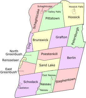
The locations of those National Register properties and districts in Rensselaer County for which latitude and longitude coordinates are listed below may be seen on a map by clicking on the links available within the table above and to the right, which allows readers to map all coordinates using online maps. [4]


    This National Park Service list is complete through NPS recent listings posted February 23, 2024. [5]

Countywide listings

[6] Name on the RegisterImageDate listed [7] Location City or townDescription
1 Adams–Myers–Bryan Farmstead August 27, 2013
(#13000629)
314 Stover Rd.
42°53′22″N73°33′48″W / 42.8895°N 73.56325°W / 42.8895; -73.56325 (Adams–Myers–Bryan Farmstead)
Valley Falls Farmsteads of Pittstown NY MPS
2 Aiken House
Aiken House Aiken House Rensselaer NY Oct 10.jpg
Aiken House
December 31, 1974
(#74001296)
Northeast corner of Riverside and Aiken Aves.
42°38′08″N73°44′58″W / 42.6356°N 73.7494°W / 42.6356; -73.7494 (Aiken House)
Rensselaer
3 Albany Avenue Historic District November 21, 1978
(#78001902)
Albany Ave.
42°31′01″N73°36′55″W / 42.5169°N 73.6153°W / 42.5169; -73.6153 (Albany Avenue Historic District)
Nassau
4 Auclair–Button Farmstead June 5, 2013
(#13000360)
80 Auclair Way
42°48′34″N73°34′40″W / 42.8094°N 73.5778°W / 42.8094; -73.5778 (Auclair–Button Farmstead)
Melrose Farmsteads of Pittstown, New York MPS
5 William Barnet & Son Shoddy Mill
William Barnet & Son Shoddy Mill William Barnet & Son Shoddy Mill, Rensselaer, NY.jpg
William Barnet & Son Shoddy Mill
October 29, 2020
(#100005703)
20 Forbes Ave.
42°39′33″N73°43′58″W / 42.6591°N 73.7328°W / 42.6591; -73.7328 (William Barnet & Son Shoddy Mill)
Rensselaer
6 Baum–Wallis Farmstead January 2, 2013
(#12001130)
132 Baum Rd.
42°53′27″N73°30′21″W / 42.8909°N 73.5057°W / 42.8909; -73.5057 (Baum–Wallis Farmstead)
Johnsonville vicinityFarmsteads of Pittstown, New York MPS
7 Bennington Battlefield
Bennington Battlefield Bennington Battlefield State Historic Site 30May2008.jpg
Bennington Battlefield
October 15, 1966
(#66000564)
NY 67, on VT state line
42°56′02″N73°18′25″W / 42.9339°N 73.3069°W / 42.9339; -73.3069 (Bennington Battlefield)
Walloomsac Site of key American victory over British during Revolution. [8]
8 Beverwyck Manor
Beverwyck Manor Beverwyck, Washinghton Avenue extension, Rensselaer (Rensselaer County, New York).jpg
Beverwyck Manor
August 3, 1979
(#79001621)
St. Anthonys Lane.
42°39′48″N73°43′22″W / 42.6633°N 73.7228°W / 42.6633; -73.7228 (Beverwyck Manor)
Rensselaer
9 Blink Bonnie
Blink Bonnie SchodackNY BlinkBonnie.jpg
Blink Bonnie
August 10, 2000
(#00000958)
1368 Sunset Rd.
42°34′06″N73°42′09″W / 42.5683°N 73.7025°W / 42.5683; -73.7025 (Blink Bonnie)
Schodack
10 Breese-Reynolds House
Breese-Reynolds House HoosickNY BreeseReynoldsHouse.jpg
Breese-Reynolds House
March 1, 2007
(#07000096)
601 South St.
42°51′29″N73°19′27″W / 42.8580°N 73.3243°W / 42.8580; -73.3243 (Breese-Reynolds House)
Hoosick Built by Perry Eldridge in 1880.
11 Brownell–Cornell–Gibbs Farmstead September 19, 2012
(#12000796)
606 Groveside Rd.
42°53′00″N73°26′28″W / 42.8832°N 73.4410°W / 42.8832; -73.4410 (Brownell–Cornell–Gibbs Farmstead)
Buskirk vicinity
12 Burden Iron Works Site
Burden Iron Works Site Burden Wheel.png
Burden Iron Works Site
November 10, 1977
(#77000977)
Address Restricted
Troy
13 Burden Ironworks Office Building
Burden Ironworks Office Building Burden iron works office.JPG
Burden Ironworks Office Building
March 16, 1972
(#72000907)
Polk St.
42°42′35″N73°41′58″W / 42.7097°N 73.6994°W / 42.7097; -73.6994 (Burden Ironworks Office Building)
Troy
14 Buskirk Covered Bridge
Buskirk Covered Bridge Buskirks Bridge 1.jpg
Buskirk Covered Bridge
March 8, 1978
(#78003457)
Spans Hoosic River North of NY 67
42°57′30″N73°26′00″W / 42.9583°N 73.4333°W / 42.9583; -73.4333 (Buskirk Covered Bridge)
Buskirk part of the Covered Bridges of Washington County Thematic Resource (TR)
15 Esek Bussey Firehouse
Esek Bussey Firehouse Esek Bussey Firehouse (Troy, New York).jpg
Esek Bussey Firehouse
July 16, 1973
(#73001252)
302 10th St.
42°44′21″N73°40′26″W / 42.7392°N 73.6739°W / 42.7392; -73.6739 (Esek Bussey Firehouse)
Troy
16 Cannon–Brownell–Herrington Farmstead January 2, 2013
(#12001131)
551 Otter Creek Rd.
42°52′57″N73°30′11″W / 42.8826°N 73.5031°W / 42.8826; -73.5031 (Cannon–Brownell–Herrington Farmstead)
Johnsonville vicinity.Farmsteads of Pittstown, New York MPS
17 Cannon Building
Cannon Building CannonBuildingTroy.jpg
Cannon Building
March 5, 1970
(#70000427)
1 Broadway
42°43′53″N73°41′32″W / 42.7314°N 73.6922°W / 42.7314; -73.6922 (Cannon Building)
Troy 1835 Alexander Jackson Davis-Ithiel Town commercial building further enhanced with mansard roof after 1870s fire. [9]
18 John Carner Jr. House
John Carner Jr. House Carner.jpg
John Carner Jr. House
January 16, 2004
(#03001399)
1310 Best Rd.
42°37′50″N73°39′58″W / 42.6306°N 73.6661°W / 42.6306; -73.6661 (John Carner Jr. House)
East Greenbush
19 Cartin–Snyder–Overacker Farmstead June 5, 2013
(#13000361)
559 Cushman Rd.
42°50′00″N73°33′31″W / 42.8333°N 73.55864°W / 42.8333; -73.55864 (Cartin–Snyder–Overacker Farmstead)
Melrose Farmsteads of Pittstown, New York MPS
20 Catholic Central High School
Catholic Central High School Catholic Central High School (Troy, New York).jpg
Catholic Central High School
January 19, 2024
(#100009781)
625 7th Avenue
42°46′30″N73°40′14″W / 42.7751°N 73.6706°W / 42.7751; -73.6706 (Catholic Central High School)
Troy
21 Central Lansingburgh Historic District February 27, 2023
(#100008651)
1st Ave., 110th and 111th Sts., east alleys of 5th and 6th Aves., 117th and 120th Sts., east and west alleys of 2nd Ave.,
42°46′24″N73°40′34″W / 42.7732°N 73.6761°W / 42.7732; -73.6761 (Central Lansingburgh Historic District)
Troy
22 Central Troy Historic District
Central Troy Historic District TroyCentralHistoricDistrict.JPG
Central Troy Historic District
August 13, 1986
(#86001527)
Adams, 1st, 4th, Washington & Hill Sts., Franklin Pl., 5th Ave.
42°43′41″N73°41′31″W / 42.7281°N 73.6919°W / 42.7281; -73.6919 (Central Troy Historic District)
Troy 96-acre (39 ha) commercial section of downtown Troy with many buildings, including two National Historic Landmarks, from 1787-1940. [10]
23 Chapel and Cultural Center
Chapel and Cultural Center RPI Chapel Southeast.png
Chapel and Cultural Center
February 22, 2011
(#11000041)
2125 Burdett Ave.
42°43′55″N73°40′21″W / 42.7319°N 73.6725°W / 42.7319; -73.6725 (Chapel and Cultural Center)
Troy
24 Chatham Street Row
Chatham Street Row Homes on Chatham Street in Village of Nassau NY.jpg
Chatham Street Row
December 1, 1978
(#78001900)
Chatham St.
42°30′53″N73°36′40″W / 42.514722°N 73.611111°W / 42.514722; -73.611111 (Chatham Street Row)
Nassau
25 Church of the Holy Cross
Church of the Holy Cross Church of the Holy Cross, Eighth & Grand Streets, Troy (Rensselaer County, New York).jpg
Church of the Holy Cross
June 4, 1973
(#73001253)
136 8th St.
42°43′57″N73°41′01″W / 42.7325°N 73.683611°W / 42.7325; -73.683611 (Church of the Holy Cross)
Troy Gothic Revival church built in 1844.
26 Church Street Historic District
Church Street Historic District Church Street Historic District-7 Church St Nassau NY Aug 09.jpg
Church Street Historic District
November 21, 1978
(#78001901)
Church St.
42°30′54″N73°36′26″W / 42.515°N 73.607222°W / 42.515; -73.607222 (Church Street Historic District)
Nassau
27 Clark-Dearstyne-Miller Inn
Clark-Dearstyne-Miller Inn RensselaerNY ClarkDearstyneMillerInn.jpg
Clark-Dearstyne-Miller Inn
January 9, 2008
(#07001369)
11-13 Forbes Ave.
42°39′32″N73°44′06″W / 42.6589°N 73.735°W / 42.6589; -73.735 (Clark-Dearstyne-Miller Inn)
Rensselaer
28 Coletti–Rowland–Agan Farmstead August 27, 2013
(#13000631)
82 Cooksboro Rd.
42°48′16″N73°33′50″W / 42.804411°N 73.5639807°W / 42.804411; -73.5639807 (Coletti–Rowland–Agan Farmstead)
Pittstown Farmsteads of Pittstown NY MPS
29 Corliss Park Historic District February 20, 2024
(#100009935)
7th and 8th Avenues, north of Northern Drive
42°47′15″N73°39′49″W / 42.7875°N 73.6637°W / 42.7875; -73.6637 (Corliss Park Historic District)
Troy
30 Cornell–Manchester Farmstead October 3, 2012
(#12000832)
292 Lower Pine Valley Rd.
42°52′38″N73°26′06″W / 42.877293°N 73.435033°W / 42.877293; -73.435033 (Cornell–Manchester Farmstead)
Hoosick Falls vicinityPart of Farmsteads of Pittstown, New York MPS
31 Craver Farmstead
Craver Farmstead Craver farmstead 2014.png
Craver Farmstead
December 16, 1996
(#96001423)
115 Craver Rd.
42°37′23″N73°38′37″W / 42.623056°N 73.643611°W / 42.623056; -73.643611 (Craver Farmstead)
East Greenbush
32 Defreest Homestead
Defreest Homestead Defreest House.jpg
Defreest Homestead
August 2, 1977
(#77000978)
South of Troy at U.S. 4 and Jordan Rd.
42°40′32″N73°41′39″W / 42.675556°N 73.694167°W / 42.675556; -73.694167 (Defreest Homestead)
North Greenbush Early Dutch house built around 1750 and early Dutch barn
33 Delaney Hotel
Delaney Hotel Delany hotel.JPG
Delaney Hotel
June 21, 1996
(#96000684)
Junction of NY 22 and NY 67
42°55′37″N73°20′38″W / 42.926944°N 73.343889°W / 42.926944; -73.343889 (Delaney Hotel)
North Hoosick Intact Greek Revival hotel with vernacular Victorian features built ca. 1850 [11]
34 Dickinson Hill Fire Tower
Dickinson Hill Fire Tower Dickinson Hill Fire Tower near Grafton Lakes State Park.jpg
Dickinson Hill Fire Tower
May 6, 2011
(#11000253)
Fire Tower Rd.
42°47′37″N73°24′49″W / 42.79361°N 73.41361°W / 42.79361; -73.41361 (Dickinson Hill Fire Tower)
Grafton
35 District School No. 3
District School No. 3 CastletonSchoolDistrict3.jpg
District School No. 3
August 28, 1998
(#98001116)
1125 S. Schodack Rd.
42°30′09″N73°42′26″W / 42.5025°N 73.707222°W / 42.5025; -73.707222 (District School No. 3)
Castleton-on-Hudson
36 District #6 Schoolhouse
District #6 Schoolhouse LittleRedSchoolhouseBrunswick.jpg
District #6 Schoolhouse
July 3, 2008
(#08000582)
Brick Church Rd. and Buck Rd.
42°45′04″N73°34′29″W / 42.751192°N 73.574667°W / 42.751192; -73.574667 (District #6 Schoolhouse)
Brunswick One-room schoolhouse built c. 1830 and closed in 1952. Believed to be one of the oldest remaining schoolhouses in Rensselaer County. [12]
37 East Nassau Central School
East Nassau Central School East Nassau Central School (formerly).jpg
East Nassau Central School
May 23, 1997
(#97000418)
37 Garfield Rd.
42°30′33″N73°30′19″W / 42.509167°N 73.505278°W / 42.509167; -73.505278 (East Nassau Central School)
East Nassau
38 Elmbrook Farm
Elmbrook Farm SchodackNY ElmbrookFarm.jpg
Elmbrook Farm
May 21, 2001
(#01000551)
2567 Brookview Rd.
42°34′22″N73°42′39″W / 42.5728°N 73.7108°W / 42.5728; -73.7108 (Elmbrook Farm)
Schodack
39 Estabrook Octagon House
Estabrook Octagon House Estabrook Octagon House, Hoosick Falls, NY.jpg
Estabrook Octagon House
February 8, 1980
(#80002755)
8 River St.
42°53′47″N73°21′11″W / 42.896389°N 73.353056°W / 42.896389; -73.353056 (Estabrook Octagon House)
Hoosick Falls 1854 octagon house built closely following specifications of Orson Squire Fowler [13]
40 Fifth Avenue-Fulton Street Historic District
Fifth Avenue-Fulton Street Historic District Fifth Avenue residences, Troy, NY.jpg
Fifth Avenue-Fulton Street Historic District
March 5, 1970
(#70000428)
Bounded by Grand, William, and Union Sts., and Broadway
42°44′00″N73°40′59″W / 42.7333°N 73.6831°W / 42.7333; -73.6831 (Fifth Avenue-Fulton Street Historic District)
Troy 1860s-era homes of city's business elite. One of five districts consolidated into Central Troy Historic District
41 Fire Alarm, Telegraph and Police Signaling Building
Fire Alarm, Telegraph and Police Signaling Building FireAlarmTelegraphAndPoliceSignalingBuilding.jpg
Fire Alarm, Telegraph and Police Signaling Building
January 15, 2003
(#02001714)
67 State St.
42°43′47″N73°41′12″W / 42.729722°N 73.686667°W / 42.729722; -73.686667 (Fire Alarm, Telegraph and Police Signaling Building)
Troy 1922 building consolidated city's public safety communications systems, in wake of history of devastating fires. After a period of vacancy in late 20th century, back in service as police headquarters [14]
42 First Presbyterian Church of Lansingburgh August 3, 2022
(#100007954)
570 3rd Ave.
42°46′29″N73°40′34″W / 42.7747°N 73.6760°W / 42.7747; -73.6760 (First Presbyterian Church of Lansingburgh)
Troy
43 Fort Crailo
Fort Crailo Fort Crailo 2010.jpg
Fort Crailo
October 15, 1966
(#66000563)
South of Columbia St. on Riverside Ave.
42°38′08″N73°44′59″W / 42.6356°N 73.7497°W / 42.6356; -73.7497 (Fort Crailo)
Rensselaer Only well-preserved Dutch patroon house in upper Hudson Valley [15]
44 Albert R. Fox House
Albert R. Fox House 2801 NY 66, Sand Lake Albert R Fox House.jpg
Albert R. Fox House
April 25, 2001
(#01000430)
2801 NY 66
42°38′04″N73°32′18″W / 42.6344°N 73.5383°W / 42.6344; -73.5383 (Albert R. Fox House)
Sand Lake
45 Gardner Earl Memorial Chapel and Crematorium
Gardner Earl Memorial Chapel and Crematorium OakwoodChapel.jpg
Gardner Earl Memorial Chapel and Crematorium
February 25, 2004
(#04000091)
50 101st Street
42°45′20″N73°40′17″W / 42.7556°N 73.6714°W / 42.7556; -73.6714 (Gardner Earl Memorial Chapel and Crematorium)
Troy Richardsonian Romanesque memorial chapel in Oakwood Cemetery built by local industrialist for deceased son was highly influential on the design of other such buildings; designated a National Historic Landmark March 2, 2012
46 Garfield School
Garfield School GarfieldSchool.jpg
Garfield School
June 9, 1988
(#88000717)
NY 2 and Moonlawn Rd.
42°43′52″N73°35′56″W / 42.7311°N 73.5989°W / 42.7311; -73.5989 (Garfield School)
Brunswick First building in Brunswick to be added to the NRHP. [16] [17]
47 Glenwood May 25, 1973
(#73001254)
Eddy's Lane
42°45′04″N73°40′33″W / 42.7511°N 73.6758°W / 42.7511; -73.6758 (Glenwood)
Troy
48 Gooding Farm August 5, 2022
(#100007956)
22420 NY 22
42°55′58″N73°21′39″W / 42.9329°N 73.3607°W / 42.9329; -73.3607 (Gooding Farm)
Eagle Bridge
49 Grand Street Historic District
Grand Street Historic District Grand Street, Troy, NY.jpg
Grand Street Historic District
February 27, 1973
(#73001255)
Grand St. between 5th and 6th Aves.
42°43′59″N73°41′13″W / 42.7331°N 73.6869°W / 42.7331; -73.6869 (Grand Street Historic District)
Troy Civil War-era rowhouses built in wake of devastating 1862 fire. Now part of Central Troy Historic District.
50 Griswold Heights Historic District February 20, 2024
(#100009936)
Madison Avenue, Project Street, Project Road, and Campbell Avenue
42°42′44″N73°40′35″W / 42.7122°N 73.6763°W / 42.7122; -73.6763 (Griswold Heights Historic District)
Troy
51 Halford–Hayner Farmstead January 2, 2013
(#12001132)
346 Cooksboro Rd.
42°48′30″N73°35′29″W / 42.8083°N 73.5914°W / 42.8083; -73.5914 (Halford–Hayner Farmstead)
Troy vicinityFarmsteads of Pittstown, New York MPS
52 Harder Manufacturing Company-Albany Woolen Company Inc. Building
Harder Manufacturing Company-Albany Woolen Company Inc. Building Harder Manufacturing Company-Albany Woolen Company Inc. Building, Rensselaer NY.jpg
Harder Manufacturing Company-Albany Woolen Company Inc. Building
May 20, 2021
(#100006510)
2 Green St.
42°38′11″N73°44′46″W / 42.6365°N 73.7460°W / 42.6365; -73.7460 (Harder Manufacturing Company-Albany Woolen Company Inc. Building)
Rensselaer
53 Hart-Cluett Mansion
Hart-Cluett Mansion RensCoHistSoc.jpg
Hart-Cluett Mansion
April 11, 1973
(#73001256)
59 2nd St.
42°43′46″N73°41′38″W / 42.7294°N 73.6939°W / 42.7294; -73.6939 (Hart-Cluett Mansion)
Troy 1827 Federal style mansion is one of the best in that style in city. Home to Rensselaer County Historical Society since 1950s [18]
54 Hoosick Falls Armory
Hoosick Falls Armory Hoosick Falls Armory.jpg
Hoosick Falls Armory
March 2, 1995
(#95000086)
Junction of Church and Elm Sts.
42°53′57″N73°21′15″W / 42.8992°N 73.3542°W / 42.8992; -73.3542 (Hoosick Falls Armory)
Hoosick Falls Intact 1889 Isaac Perry-designed armory. Home to units that have fought in the Mexican Border Campaign and Battle of Saipan. [19] Part of the Army National Guard Armories in New York State Multiple Property Submission (MPS)
55 Hoosick Falls Historic District
Hoosick Falls Historic District Downtown Hoosick Falls, NY.jpg
Hoosick Falls Historic District
December 3, 1980
(#80004280)
Central Ave. and Main St.
42°54′04″N73°21′06″W / 42.9011°N 73.3517°W / 42.9011; -73.3517 (Hoosick Falls Historic District)
Hoosick Falls Eight-acre commercial core of village with intact buildings from turn-of-the-century industrial peak [20]
56 Howard–Odmin–Sherman Farmstead April 7, 2014
(#14000130)
393 Croll Road
42°51′52″N73°30′55″W / 42.86453°N 73.5152°W / 42.86453; -73.5152 (Howard–Odmin–Sherman Farmstead)
Pittstown
57 Ilium Building
Ilium Building Ilium Building, Troy, NY.jpg
Ilium Building
December 18, 1970
(#70000429)
Northeast corner of Fulton and 4th Sts.
42°43′57″N73°41′20″W / 42.7325°N 73.6889°W / 42.7325; -73.6889 (Ilium Building)
Troy Intact 1904 Marcus F. Cummings commercial building [21]
58 International Shirt and Collar Company
International Shirt and Collar Company United Waste Manufacturing Company Building (view to South).jpg
International Shirt and Collar Company
February 14, 2017
(#100000648)
2 River St.
42°43′26″N73°41′45″W / 42.7238°N 73.6958°W / 42.7238; -73.6958 (International Shirt and Collar Company)
Troy
59 W. P. Irwin Bank Building
W. P. Irwin Bank Building W. P. Irwin Bank Building Oct 10.jpg
W. P. Irwin Bank Building
October 3, 2007
(#07001036)
156 Broadway
42°38′25″N73°44′49″W / 42.6403°N 73.7469°W / 42.6403; -73.7469 (W. P. Irwin Bank Building)
Rensselaer
60 Knickerbocker Mansion
Knickerbocker Mansion Knickerbocker Mansion, Schaghticoke New York.jpg
Knickerbocker Mansion
December 11, 1972
(#72000906)
Knickerbocker Rd.
42°54′18″N73°39′08″W / 42.905°N 73.6522°W / 42.905; -73.6522 (Knickerbocker Mansion)
Schaghticoke
61 Henry Koon House
Henry Koon House Henry Koon House 171 Pawling Avenue Troy.jpg
Henry Koon House
February 21, 1997
(#97000112)
171 Pawling Ave.
42°43′00″N73°40′13″W / 42.7167°N 73.6703°W / 42.7167; -73.6703 (Henry Koon House)
Troy
62 Lansingburgh Academy
Lansingburgh Academy Lansingburgh Academy Jan 11.jpg
Lansingburgh Academy
October 14, 1976
(#76001267)
27 114th St.
42°46′22″N73°40′34″W / 42.7728°N 73.6761°W / 42.7728; -73.6761 (Lansingburgh Academy)
Troy
63 Lansingburgh Village Burial Ground
Lansingburgh Village Burial Ground Lansingburgh Village Burial Ground 2.jpg
Lansingburgh Village Burial Ground
November 21, 2002
(#02001358)
Third Ave. and 107th St.
42°45′52″N73°40′48″W / 42.7644°N 73.68°W / 42.7644; -73.68 (Lansingburgh Village Burial Ground)
Troy
64 Lion Factory April 28, 2022
(#100007669)
750 2nd Ave.
42°46′54″N73°40′26″W / 42.7816°N 73.6740°W / 42.7816; -73.6740 (Lion Factory)
Troy
65 Marsh–Link–Pollock Farm December 22, 2014
(#14001072)
66 White Church Lane
42°44′16″N73°33′14″W / 42.7379°N 73.5539°W / 42.7379; -73.5539 (Marsh–Link–Pollock Farm)
Brunswick Well-preserved 1840s farmstead
66 David Mathews House
David Mathews House BenningtonVT DavidMathewsHouse1.jpg
David Mathews House
September 10, 1979
(#79000274)
VT 67
42°56′27″N73°16′28″W / 42.9408°N 73.2744°W / 42.9408; -73.2744 (David Mathews House)
Hoosick
67 McCarthy Building
McCarthy Building McCarthyBuildingTroy2.jpeg
McCarthy Building
March 5, 1970
(#70000430)
255-257 River St.
42°43′56″N73°41′30″W / 42.7322°N 73.6917°W / 42.7322; -73.6917 (McCarthy Building)
Troy Downtown Troy landmark built in 1904 and largely intact [22]
68 Mechanicville Hydroelectric Plant
Mechanicville Hydroelectric Plant Mechanicville Hydroelectric Plant.jpg
Mechanicville Hydroelectric Plant
November 13, 1989
(#89001942)
At NY 32 on Hudson River
42°52′41″N73°40′47″W / 42.878056°N 73.679722°W / 42.878056; -73.679722 (Mechanicville Hydroelectric Plant)
Mechanicville
69 Herman Melville House
Herman Melville House Herman Melville House - Lansingburgh.JPG
Herman Melville House
August 21, 1992
(#92001081)
2 114th St.
42°46′23″N73°40′45″W / 42.773056°N 73.679167°W / 42.773056; -73.679167 (Herman Melville House)
Troy
70 Methodist Episcopal Church of Lansingburgh June 23, 2016
(#16000412)
600 3rd Ave.
42°46′32″N73°40′30″W / 42.775677°N 73.675103°W / 42.775677; -73.675103 (Methodist Episcopal Church of Lansingburgh)
Troy Center of village now part of Troy was built in 1849, expanded in 1875 and rebuilt in 1903
71 Muitzes Kill Historic District
Muitzes Kill Historic District Muitzes Kill Historic District-Reformed Church Jul 09.jpg
Muitzes Kill Historic District
July 24, 1974
(#74001297)
An irregular pattern on both sides of Schodack Landing Rd.
42°28′35″N73°43′22″W / 42.476389°N 73.722778°W / 42.476389; -73.722778 (Muitzes Kill Historic District)
Schodack
72 Kate Mullany House
Kate Mullany House Kate Mullany House oblique view.jpg
Kate Mullany House
April 1, 1998
(#98000453)
350 8th St.
42°44′24″N73°40′54″W / 42.74°N 73.681667°W / 42.74; -73.681667 (Kate Mullany House)
Troy Apartment building of teenaged Irish immigrant who organized her fellow garment workers and went on to become first major female U.S. labor leader [23]
73 National State Bank Building
National State Bank Building National State Bank Building, Troy, NY.jpg
National State Bank Building
December 29, 1970
(#70000431)
297 River St.
42°43′57″N73°41′27″W / 42.7325°N 73.690833°W / 42.7325; -73.690833 (National State Bank Building)
Troy 1904 Marcus F. Cummings building shows influence of early skyscrapers; has been Monument Square landmark since its construction. [24]
74 Newton–Taber–Martin Farm
Newton-Taber-Martin Farm 149 Clarks Chapel Road from front lawn.jpg
Newton–Taber–Martin Farm
November 2, 2016
(#16000752)
149 Clarks Chapel Rd.
42°34′47″N73°34′40″W / 42.579822°N 73.577880°W / 42.579822; -73.577880 (Newton–Taber–Martin Farm)
Nassau Continuously operated farm dates to 1788, when it was established by a Revolutionary War veteran from Massachusetts
75 New York State Barge Canal
New York State Barge Canal Federal lock 2006.jpg
New York State Barge Canal
October 15, 2014
(#14000860)
Hudson River
42°47′18″N73°40′21″W / 42.788316°N 73.672442°W / 42.788316; -73.672442 (New York State Barge Canal)
Troy and SchaghticokeSuccessor to Erie Canal approved by state voters in early 20th century to compete with railroads.
76 Northern River Street Historic District
Northern River Street Historic District RiverStreetTroyNY.JPG
Northern River Street Historic District
May 19, 1988
(#88000630)
403-429 and 420-430 River St.
42°44′08″N73°41′17″W / 42.735556°N 73.688056°W / 42.735556; -73.688056 (Northern River Street Historic District)
Troy Transitional neighborhood between downtown and industrial areas in late 19th century; largely unchanged since then [25]
77 Oakwood Avenue Presbyterian Church
Oakwood Avenue Presbyterian Church Oakwood Avenue Presbyterian Church Troy NY Jan 11.jpg
Oakwood Avenue Presbyterian Church
November 21, 2012
(#12000959)
313 10th St.
42°44′24″N73°40′47″W / 42.74011°N 73.679792°W / 42.74011; -73.679792 (Oakwood Avenue Presbyterian Church)
Troy
78 Oakwood Cemetery
Oakwood Cemetery Warren Chapel Oakwood 2.JPG
Oakwood Cemetery
October 4, 1984
(#84000021)
50 101st St.
42°45′44″N73°40′12″W / 42.762222°N 73.67°W / 42.762222; -73.67 (Oakwood Cemetery)
Troy Burial site of "Uncle Sam" Wilson and Civil War Gen. George H. Thomas [26]
79 Old Troy Hospital
Old Troy Hospital WestHallRPIPano.jpg
Old Troy Hospital
October 25, 1973
(#73001257)
8th St.
42°43′54″N73°41′00″W / 42.731667°N 73.683333°W / 42.731667; -73.683333 (Old Troy Hospital)
Troy Also known as West Hall. French Second Empire structure home to Arts Department at RPI
80 J. C. Osgood Firehouse November 2, 2000
(#00001231)
316-324 Third St.
42°43′10″N73°41′35″W / 42.719444°N 73.693056°W / 42.719444; -73.693056 (J. C. Osgood Firehouse)
Troy
81 Jacob H. Patten House January 5, 2016
(#15000954)
254 4th Ave.
42°45′44″N73°40′56″W / 42.7621592°N 73.6823166°W / 42.7621592; -73.6823166 (Jacob H. Patten House)
Troy 1882 brick Italianate townhouse and carriage house built for successful local blacksmith
82 Patroon Agent's House and Office
Patroon Agent's House and Office RensselaerNY 15ForbesAve.jpg
Patroon Agent's House and Office
August 3, 1979
(#79001622)
15 Forbes Ave.
42°39′26″N73°44′07″W / 42.6572°N 73.7353°W / 42.6572; -73.7353 (Patroon Agent's House and Office)
Rensselaer
83 Petersburgh United Methodist Church
Petersburgh United Methodist Church Petersburgh United Methodist Church Jun 10.jpg
Petersburgh United Methodist Church
January 2, 2004
(#03001354)
12 Head of Lane Rd.
42°45′08″N73°20′44″W / 42.752222°N 73.345556°W / 42.752222; -73.345556 (Petersburgh United Methodist Church)
Petersburgh
84 Poesten Kill Gorge Historic District March 8, 1978
(#78001903)
Address Restricted
Troy Try also Poestenkill Gorge Historic District
85 Powers Home April 16, 1974
(#74001298)
819 3rd Ave.
42°47′02″N73°40′22″W / 42.783889°N 73.672778°W / 42.783889; -73.672778 (Powers Home)
Troy
86 Proctor's Theater
Proctor's Theater ProctorsTroy.jpg
Proctor's Theater
October 4, 1979
(#79001623)
82 4th St.
42°43′55″N73°41′25″W / 42.731944°N 73.690278°W / 42.731944; -73.690278 (Proctor's Theater)
Troy 1914 theater shows transition between eras of live entertainment and motion picture. [27] Part of the Movie Palaces of the Tri-Cities TR
87 Public School No.1 December 7, 2018
(#100003232)
2920 Fifth Avenue
42°44′49″N73°40′56″W / 42.7469°N 73.6823°W / 42.7469; -73.6823 (Public School No.1)
Troy 1910 brick school built to serve newly annexed Lansingburgh neighborhood was used by district until 2013
88 Public School No. 10
Public School No. 10 Troy Public School 10 (formerly).jpg
Public School No. 10
November 4, 1994
(#94001281)
77 Adams St.
42°43′22″N73°41′34″W / 42.722778°N 73.692778°W / 42.722778; -73.692778 (Public School No. 10)
Troy
89 Pumpkin House
Pumpkin House Pumpkin House, Troy, NY (street view toward North).jpg
Pumpkin House
June 8, 1998
(#98000573)
180 Fourth St.
42°43′35″N73°41′26″W / 42.726389°N 73.690556°W / 42.726389; -73.690556 (Pumpkin House)
Troy
90 Rensselaer Society of Engineers House
Rensselaer Society of Engineers House Rensselaer Society of Engineers clubhouse (rear view).jpg
Rensselaer Society of Engineers House
April 5, 2019
(#100003629)
1501 Sage Avenue
42°43′47″N73°40′31″W / 42.7297°N 73.6753°W / 42.7297; -73.6753 (Rensselaer Society of Engineers House)
Troy Large 1924 Colonial Revival brick building home to Rensselaer Society of Engineers
91 River Street Historic District
River Street Historic District RiverStreetTroy.jpg
River Street Historic District
June 3, 1976
(#76001268)
Both sides of River St. from Congress St. to junction with 1st St.
42°43′49″N73°41′42″W / 42.730278°N 73.695°W / 42.730278; -73.695 (River Street Historic District)
Troy Oldest downtown neighborhood in city, largely rebuilt after 1820 fire. Now part of Central Troy Historic District.
92 Sand Lake Baptist Church
Sand Lake Baptist Church Sand Lake Baptist Church May 10.jpg
Sand Lake Baptist Church
January 2, 2004
(#03001353)
2960 NY 43
42°38′07″N73°32′59″W / 42.635278°N 73.549722°W / 42.635278; -73.549722 (Sand Lake Baptist Church)
Averill Park
93 Schodack Landing Historic District
Schodack Landing Historic District William Gardineer House Schodack Landing Historic District Dec 11.jpg
Schodack Landing Historic District
September 15, 1977
(#77000976)
NY 9J
42°28′58″N73°46′07″W / 42.482778°N 73.768611°W / 42.482778; -73.768611 (Schodack Landing Historic District)
Schodack Landing
94 Searle, Gardner and Company Cuff and Collar Factory January 15, 2014
(#13001092)
701–715 River St.
42°44′48″N73°41′09″W / 42.746653°N 73.6858526°W / 42.746653; -73.6858526 (Searle, Gardner and Company Cuff and Collar Factory)
Troy Old textile plant
95 Second Street Historic District
Second Street Historic District Second Street, Troy, NY.jpg
Second Street Historic District
August 7, 1974
(#74001299)
Both sides of 2nd St.
42°43′53″N73°41′40″W / 42.731389°N 73.694444°W / 42.731389; -73.694444 (Second Street Historic District)
Troy Troy's first desirable residential neighborhood. Many houses from 1820s-1840s. Merged into Central Troy Historic District in 1986.
96 Sharpe Homestead and Cemetery
Sharpe Homestead and Cemetery DefreestvilleNY 44LauraLane.jpg
Sharpe Homestead and Cemetery
May 19, 2005
(#05000440)
44 Laura Ln.
42°39′40″N73°41′57″W / 42.6611°N 73.6992°W / 42.6611; -73.6992 (Sharpe Homestead and Cemetery)
Defreestville
97 Sherman Farm July 5, 2003
(#03000597)
35 Sherman Rd.
42°51′23″N73°30′37″W / 42.856389°N 73.510278°W / 42.856389; -73.510278 (Sherman Farm)
Pittstown
98 Henry Tunis Smith Farm September 18, 1975
(#75001222)
South of Nassau on NY 203
42°29′37″N73°37′10″W / 42.493611°N 73.619444°W / 42.493611; -73.619444 (Henry Tunis Smith Farm)
Nassau
99 St. Barnabas Episcopal Church January 28, 2004
(#03001517)
2900 Fifth Ave.
42°44′46″N73°40′58″W / 42.746111°N 73.682778°W / 42.746111; -73.682778 (St. Barnabas Episcopal Church)
Troy
100 St. Mark's Episcopal Church
St. Mark's Episcopal Church St Mark's Episcopal Church, Hoosick Falls, NY.jpg
St. Mark's Episcopal Church
July 27, 2000
(#00000836)
Main St.
42°53′59″N73°21′02″W / 42.899722°N 73.350556°W / 42.899722; -73.350556 (St. Mark's Episcopal Church)
Hoosick Falls 1858 Henry Dudley church done in brick rather than his usual stone [28]
101 St. Paul's Episcopal Church Complex
St. Paul's Episcopal Church Complex StPaulsTroy.jpg
St. Paul's Episcopal Church Complex
September 7, 1979
(#79001624)
58 3rd St.
42°43′49″N73°41′24″W / 42.730278°N 73.69°W / 42.730278; -73.69 (St. Paul's Episcopal Church Complex)
Troy 1828 church is early Gothic Revival imitation of Ithiel Town's Trinity Church in New Haven, Connecticut [29]
102 Joachim Staats House and Gerrit Staats Ruin December 15, 1978
(#78001898)
North of Castleton-on-Hudson
42°34′15″N73°44′58″W / 42.570833°N 73.749444°W / 42.570833; -73.749444 (Joachim Staats House and Gerrit Staats Ruin)
Castleton-on-Hudson
103 Theta Xi Fraternity Chapter House December 11, 2013
(#13000911)
1490 Sage Ave.
42°43′50″N73°40′38″W / 42.730445°N 73.6773301°W / 42.730445; -73.6773301 (Theta Xi Fraternity Chapter House)
Troy Well-preserved 1931 Tudor Revival fraternity house
104 Thomas–Wiley–Johnson Farmstead September 19, 2012
(#12000798)
703 Johnsonville Rd.
42°52′19″N73°29′51″W / 42.872025°N 73.49755°W / 42.872025; -73.49755 (Thomas–Wiley–Johnson Farmstead)
Johnsonville vicinity
105 Tibbits House
Tibbits House HoosickNY HoosacSchool TibbitsHouse1.jpg
Tibbits House
May 22, 1978
(#78001899)
South of Hoosick at junction of NY 22 and NY 7
42°51′28″N73°20′37″W / 42.857778°N 73.343611°W / 42.857778; -73.343611 (Tibbits House)
Hoosick
106 Tomhannock Methodist Episcopal Church
Tomhannock Methodist Episcopal Church Tomhannock Methodist Episcopal Church.jpg
Tomhannock Methodist Episcopal Church
May 27, 2014
(#14000262)
Tomhannock Rd.
42°52′10″N73°32′53″W / 42.869492995785556°N 73.54792977620264°W / 42.869492995785556; -73.54792977620264 (Tomhannock Methodist Episcopal Church)
Pittstown
107 Trinity Church Lansingburgh
Trinity Church Lansingburgh Trinity Church Lansingburgh Jan 11.jpg
Trinity Church Lansingburgh
May 1, 1995
(#95000478)
585 Fourth Ave.
42°46′28″N73°40′32″W / 42.774444°N 73.675556°W / 42.774444; -73.675556 (Trinity Church Lansingburgh)
Troy
108 Troy Gas Light Company
Troy Gas Light Company Troy Gas Light Company, Gasholder House, Jefferson Street & Fifth Avenue, Troy (Rensselaer County, New York).jpg
Troy Gas Light Company
February 18, 1971
(#71000556)
Northwest corner of Jefferson St. and 5th Ave.
42°43′17″N73°41′26″W / 42.721389°N 73.690556°W / 42.721389; -73.690556 (Troy Gas Light Company)
Troy Structure used to hold coal gas in the 1800s.
109 Troy Public Library
Troy Public Library TroyPublicLibrary.jpg
Troy Public Library
January 17, 1973
(#73001258)
100 2nd St.
42°44′46″N73°40′59″W / 42.746111°N 73.683056°W / 42.746111; -73.683056 (Troy Public Library)
Troy
110 Troy Savings Bank and Music Hall
Troy Savings Bank and Music Hall Troy Savings Bank.jpg
Troy Savings Bank and Music Hall
April 11, 1989
(#89001066)
32 Second St.
42°43′49″N73°41′31″W / 42.730278°N 73.691944°W / 42.730278; -73.691944 (Troy Savings Bank and Music Hall)
Troy Late 19th-century bank building with full theater, including pipe organ, upstairs
111 Troy Waste Manufacturing Company Building February 14, 2014
(#14000008)
444 River St.
42°44′11″N73°41′21″W / 42.7364303°N 73.6891707°W / 42.7364303; -73.6891707 (Troy Waste Manufacturing Company Building)
Troy Textile Factory Buildings in Troy, New York, 1880-1920 MPS
112 US Post Office-Hoosick Falls
US Post Office-Hoosick Falls Hoosick Falls, NY, post office.jpg
US Post Office-Hoosick Falls
November 17, 1988
(#88002506)
35 Main St.
42°54′02″N73°21′05″W / 42.900556°N 73.351389°W / 42.900556; -73.351389 (US Post Office-Hoosick Falls)
Hoosick Falls 1925 brick Colonial Revival building mostly intact; [30] part of the US Post Offices in New York State, 1858-1943, TR
113 US Post Office-Troy
US Post Office-Troy TroyPostOffice2.jpg
US Post Office-Troy
May 11, 1989
(#88002438)
400 Broadway
42°43′53″N73°41′21″W / 42.731389°N 73.689167°W / 42.731389; -73.689167 (US Post Office-Troy)
Troy Stripped Classical Revival-style building from 1936, excellent example of that sort of architecture in larger city post offices during Depression. One of only three in the U.S. with interior mural by Waldo Peirce. [31] Part of the US Post Offices in New York State, 1858-1943, TR
114 United Waste Manufacturing Company Building
United Waste Manufacturing Company Building United Waste Manufacturing Company Building (view toward West).jpg
United Waste Manufacturing Company Building
March 6, 2013
(#13000054)
1 Jackson St.
42°42′57″N73°41′46″W / 42.71593°N 73.6961°W / 42.71593; -73.6961 (United Waste Manufacturing Company Building)
Troy Castellated Romanesque factory building on the Hudson River dating to 1902
115 John Evert Van Alen House
John Evert Van Alen House DefreestvilleNY JohnEvertVanAlenHouse.jpg
John Evert Van Alen House
August 20, 2004
(#04000873)
1744 Washington Ave. Ext.
42°39′11″N73°41′56″W / 42.6531°N 73.6989°W / 42.6531; -73.6989 (John Evert Van Alen House)
Defreestville
116 Van Rensselaer High School
Van Rensselaer High School Doane Stuart School, Rensselaer NY.jpg
Van Rensselaer High School
August 14, 2012
(#12000511)
199 Washington Ave.
42°39′32″N73°43′37″W / 42.659014°N 73.726889°W / 42.659014; -73.726889 (Van Rensselaer High School)
Rensselaer
117 Valley Falls Historic District
Valley Falls Historic District Valley Falls NY Community Hall.jpg
Valley Falls Historic District
November 9, 2018
(#100003118)
State, Burton, Charles & Edward Sts.
42°53′57″N73°33′41″W / 42.8992°N 73.5613°W / 42.8992; -73.5613 (Valley Falls Historic District)
Valley Falls Properties in core of industrial village date to 1830s
118 Van Zandt, Jacobs and Company Collar and Cuff Factory
Van Zandt, Jacobs and Company Collar and Cuff Factory Van Zandt, Jacobs and Company Collar and Cuff Factory.jpg
Van Zandt, Jacobs and Company Collar and Cuff Factory
February 14, 2014
(#14000009)
621 River St.
42°44′35″N73°41′15″W / 42.7429497°N 73.6875712°W / 42.7429497; -73.6875712 (Van Zandt, Jacobs and Company Collar and Cuff Factory)
Troy Textile Factory Buildings in Troy, New York, 1880-1920 MPS
119 W. & L. E. Gurley Building
W. & L. E. Gurley Building Gurley Building 2008.jpg
W. & L. E. Gurley Building
March 5, 1970
(#70000432)
514 Fulton St.
42°43′57″N73°41′18″W / 42.7325°N 73.688333°W / 42.7325; -73.688333 (W. & L. E. Gurley Building)
Troy Exemplary Neoclassical commercial building preserved nearly intact; built in only eight months on site of 1845 original after 1862 fire. Home of Gurley Precision Instruments for over 150 years. [32]
120 Washington Park Historic District
Washington Park Historic District WashingtonParkTroy.jpg
Washington Park Historic District
May 25, 1973
(#73001259)
Washington Park and adjacent properties on 2nd, 3rd, and Washington Sts. and Washington Pl.
42°43′26″N73°41′35″W / 42.723889°N 73.693056°W / 42.723889; -73.693056 (Washington Park Historic District)
Troy Rows of townhouses built by local businessmen in 1839 on the model of British residential squares in Bloomsbury. Residents are still assessed for the maintenance of the park. Now part of Central Troy Historic District.
121 Wilbur–Campbell–Stephens Company Cuff and Collar Factory February 2, 2016
(#15001026)
599 River Street
42°44′32″N73°41′17″W / 42.742291°N 73.6879457°W / 42.742291; -73.6879457 (Wilbur–Campbell–Stephens Company Cuff and Collar Factory)
Troy 1899 factory building is one of five on the street.
122 Emma Willard School
Emma Willard School EmmaWillardSchool.JPG
Emma Willard School
August 30, 1979
(#79001625)
Pawling and Elmgrove Aves.
42°42′48″N73°39′44″W / 42.713333°N 73.662222°W / 42.713333; -73.662222 (Emma Willard School)
Troy
123 William Connors Paint Manufacturing Company Building July 28, 2016
(#16000486)
669 River St.
42°44′42″N73°41′05″W / 42.744927°N 73.684651°W / 42.744927; -73.684651 (William Connors Paint Manufacturing Company Building)
Troy 1880s structure home to one of the first companies to make ready-mixed paint widely available in sealed cans.
124 Winslow Chemical Laboratory
Winslow Chemical Laboratory RPI Winslow lab.jpg
Winslow Chemical Laboratory
November 4, 1994
(#94001284)
105 Eighth St.
42°43′52″N73°41′05″W / 42.731111°N 73.684722°W / 42.731111; -73.684722 (Winslow Chemical Laboratory)
Troy 1866 structure on RPI campus.

Former listings

[6] Name on the RegisterImageDate listedDate removedLocationCity or townDescription
1 Haskell School
Haskell School Haskell School (Troy, New York).jpg
Haskell School
September 19, 2003
(#03000244)
November 15, 2023150 Sixth Ave.
42°45′28″N73°40′42″W / 42.7578°N 73.6783°W / 42.7578; -73.6783 (Haskell School)
Troy

See also

References and notes

  1. "Freedoms, as Given by the Council of the Nineteen of the Chartered West India Company to All those who Want to Establish a Colony in New Netherland". World Digital Library . 1630. Retrieved 2013-07-28.
  2. "Rensselaer County History". Rensselaer County Historical Society. Retrieved July 3, 2018.
  3. (N.Y. Laws 1791, 14th sess., ch. 4/p. 201).
  4. The latitude and longitude information provided in this table was derived originally from the National Register Information System, which has been found to be fairly accurate for about 99% of listings. Some locations in this table may have been corrected to current GPS standards.
  5. National Park Service, United States Department of the Interior, "National Register of Historic Places: Weekly List Actions", retrieved February 23, 2024.
  6. 1 2 Numbers represent an alphabetical ordering by significant words. Various colorings, defined here, differentiate National Historic Landmarks and historic districts from other NRHP buildings, structures, sites or objects.
  7. The eight-digit number below each date is the number assigned to each location in the National Register Information System database, which can be viewed by clicking the number.
  8. Richard Greenwood (November 24, 1975), National Register of Historic Places Inventory-Nomination: Bennington Battlefield (PDF), National Park Service and Accompanying 10 photos from 1967 and 1975  (1.28 MB)
  9. Peckham, Mark (July 1986). "National Register of Historic Places nomination, Central Troy Historic District (requires JavaScript)". New York State Office of Parks, Recreation and Historic Preservation. Archived from the original on 2011-12-10. Retrieved 2008-10-26.. Also see excerpts at "Central Troy Historic District". Livingplaces.com., which does not require JavaScript to view.
  10. Peckham, Mark (July 1986). "National Register of Historic Places nomination, Central Troy Historic District". New York State Office of Parks, Recreation and Historic Preservation (NYSOPRHP). Archived from the original on 2011-12-10. Retrieved 2008-10-26.. Also see excerpts at "Central Troy Historic District". Livingplaces.com., which does not require JavaScript to view. Page numbers used for the former version are those assigned by the JavaScript reader at the NYSOPRHP site, not those used in the document itself.
  11. DiSanto, Victor. "National Register of Historic Places nomination, Delaney Hotel". New York State Office of Parks, Recreation and Historic Preservation . Retrieved October 27, 2009.
  12. Zankel, Sharon (2008-04-22). "National Register of Historic Places nomination, District 6 Schoolhouse (Javascript)". New York State Office of Parks, Recreation and Historic Preservation. Archived from the original on 2011-12-10. Retrieved 2009-06-25.
  13. Harwood, John (November 15, 1979). "National Register of Historic Places nomination, Estabrook Octagon House". New York State Office of Parks, Recreation and Historic Preservation . Retrieved October 27, 2009.
  14. Shaver, Peter (2002-06-17). "National Register of Historic Places nomination; Fire Alarm, Telegraph and Police Signaling Building". New York State Office of Parks, Recreation and Historic Preservation . Retrieved 2008-10-26.
  15. James Dillon (1983), National Register of Historic Places Inventory-Nomination: Fort Crailo (PDF), National Park Service and Accompanying photos, exterior, from 1965.  (1.27 MB)
  16. Ingraham, Frances (1993-04-25). "Eagle Mills' Rural Charm Keeps Longtime Residents". Times Union (Albany). pp. G1. Retrieved 2009-06-14.[ permanent dead link ]
  17. Waite, Diana S. (1988-04-29). "National Register of Historic Places Registration nomination, Garfield School (Javascript)". New York State Office of Parks, Recreation and Historic Preservation. Archived from the original on 2011-12-10. Retrieved 2009-06-25.
  18. Brooke, Cornelia (September 1971). "National Register of Historic Places nomination, Hart-Cluett Mansion". New York State Office of Parks, Recreation and Historic Preservation. Archived from the original on 2011-12-10. Retrieved 2008-11-01.
  19. Todd, Nancy (December 1994). "National Register of Historic Places nomination, Hoosick Falls Armory". New York State Office of Parks, Recreation and Historic Preservation. Archived from the original on December 10, 2011. Retrieved October 25, 2009.
  20. Powers, Robert (August 1979). "National Register of Historic Places nomination, Hoosick Falls Historic District". New York State Office of Parks, Recreation and Historic Preservation. Archived from the original on December 10, 2011. Retrieved October 22, 2009.
  21. Liebs, Chester (May 1970). "National Register of Historic Places nomination, Ilium Building". New York State Office of Parks, Recreation and Historic Preservation . Retrieved 2008-11-11.
  22. Waite, Diana (December 1969). "National Register of Historic Places nomination, McCarthy Building". New York State Office of Parks, Recreation and Historic Preservation. Archived from the original on 2011-12-10. Retrieved 2008-11-06.
  23. Page Putnam Miller; Jill S. Mesirow; Andrew Laas; John W. Bond & Rachel Bliven (September 4, 1997), National Historic Landmark NominationKate Mullany House (PDF), National Park Service and Accompanying 2 photos, from 1994.  (493 KB)
  24. Liebs, Chester (May 1970). "National Register of Historic Places nomination, National State Bank Building". New York State Office of Parks, Recreation and Historic Preservation . Retrieved 2008-11-01.
  25. Smith, Raymond (February 1988). "National Register of Historic Places nomination, Northern River Street Historic District". New York State Office of Parks, Recreation and Historic Preservation. Archived from the original on 2011-12-10. Retrieved 2008-10-26.
  26. Harrison, A. Rebecca (1984-08-03). "National Register of Historic Places Registration nomination, Oakwood Cemetery (Javascript)". New York State Office of Parks, Recreation and Historic Preservation. Archived from the original on 2011-12-10. Retrieved 2009-10-06.
  27. Powers, Robert (May 1979). "National Register of Historic Places nomination, Proctor's Theater". New York State Office of Parks, Recreation and Historic Preservation. Archived from the original on 2011-12-10. Retrieved 2008-10-28.
  28. Shaver, Peter (November 24, 1999). "National Register of Historic Places nomination, St. Mark's Episcopal Church". New York State Office of Parks, Recreation and Historic Preservation. Archived from the original on December 10, 2011. Retrieved October 24, 2009.
  29. Dunn, Shirley (June 19, 1979). "National Register of Historic Places nomination, St. Paul's Episcopal Church (JavaScript)". New York State Office of Parks, Recreation and Historic Preservation. Archived from the original on December 10, 2011. Retrieved 2008-11-08.
  30. Gobrecht, Larry (December 1986). "National Register of Historic Places nomination, US Post Office–Hoosick Falls". New York State Office of Parks, Recreation and Historic Preservation. Archived from the original on December 10, 2011. Retrieved October 21, 2009.
  31. Gobrecht, Larry (December 1986). "National Register of Historic Places nomination, U.S. Post Office-Troy". New York State Office of Parks, Recreation and Historic Preservation. Archived from the original on 2011-12-10. Retrieved 2008-10-25.
  32. George R. Adams (November 1977), National Register of Historic Places Inventory-Nomination: W. & L.E. Gurley Building (PDF), National Park Service and Accompanying 6 photos, 5 exterior and 1 interior, from 1977 and c.1970  (1.53 MB)

Related Research Articles

<span class="mw-page-title-main">Brunswick, New York</span> Town in New York, United States

Brunswick is a town in Rensselaer County, New York, United States. The municipality was originally settled in the early 18th century. During its history, it had been part of Albany County, Rensselaerswyck, and Troy, before its incorporation in 1807. It is bordered on the west by the city of Troy; on the north by Schaghticoke and Pittstown; on the east by Grafton; and on the south by Poestenkill and North Greenbush. The population was 12,581 at the 2020 census. The source of the town's name is not certain, though some claim it comes from the source of its first inhabitants from the province of Brunswick-Lüneburg in Germany.

<span class="mw-page-title-main">Hoosick, New York</span> Town in New York, United States

Hoosick is a town in Rensselaer County, New York, United States. The population was 6,711 at the 2020 census. It was named from the Hoosic River.

<span class="mw-page-title-main">Pittstown, New York</span> Town in New York, United States

Pittstown is a town in Rensselaer County, New York, United States. The population was 5,735 at the 2010 census. It is in the northern part of the county.

<span class="mw-page-title-main">National Register of Historic Places listings in Onondaga County, New York</span>

This is a list of the properties and districts listed on the National Register of Historic Places listings in Onondaga County, New York. The locations of National Register properties and districts may be seen in a map by clicking on "Map of all coordinates". There are 170 properties and districts listed on the National Register in the county. Of those, 55 are outside Syracuse, and are listed here, while the rest are covered in National Register of Historic Places listings in Syracuse, New York. One property, the New York State Barge Canal, spans the city and the remainder of the county.

<span class="mw-page-title-main">National Register of Historic Places listings in Orleans County, New York</span> List of properties and districts listed on the National Register of Historic Places

This is intended to be a complete list of properties and districts listed on the National Register of Historic Places in Orleans County, New York. The locations of National Register properties and districts may be seen in a map by clicking on "Map of all coordinates". Two listings, the New York State Barge Canal and the Cobblestone Historic District, are further designated a National Historic Landmark.

<span class="mw-page-title-main">Buskirk Bridge</span> United States historic place

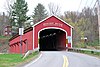
Buskirk Bridge is a wooden covered bridge and is the name of the hamlet in which it is located. It is in the town of Hoosick. The bridge, which crosses the Hoosic River is one of 29 historic covered bridges in New York State. The bridge takes its name from the nearby hamlet of the same name, which was named after the local Van Buskirk family.

<span class="mw-page-title-main">Clums Corners, New York</span> Hamlet in New York, United States

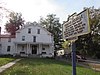
Clums Corners is a hamlet in the town of Brunswick in Rensselaer County, New York, United States. It is located at the intersection of New York Route 2, New York Route 278, and Tamarac Road. Tamarac Secondary and Elementary Schools are located nearby. The site is so named for the Clum family—specifically James Clum and later his son Orlin—who ran a blacksmith shop during the late 19th century and early 20th century.

<span class="mw-page-title-main">Brunswick (Brittonkill) Central School District</span> School district in the U.S. state of New York

Brunswick (Brittonkill) Central School District (BCSD) is a rural fringe central school district located east of the city of Troy whose main campus resides in the town of Brunswick in Rensselaer County, New York, United States. The district has two operating school buildings: Tamarac Elementary School and Tamarac Secondary School. The district is a member of the Rensselaer-Columbia-Greene Boards of Cooperative Educational Services (BOCES), known as Questar III.

<span class="mw-page-title-main">Cannon Building (Troy, New York)</span> United States historic place

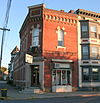
The Cannon Building in Troy, New York is located on Broadway between First and State streets. It is the oldest building on Monument Square. It was designed by Alexander Jackson Davis and built in 1835. In 1970 it was listed on the National Register of Historic Places. It is also a contributing property to the Central Troy Historic District, listed on the Register in 1986.

<span class="mw-page-title-main">Central Troy Historic District</span> Historic district in New York, United States

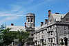
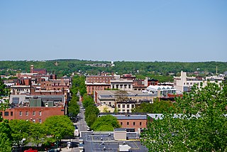
The Central Troy Historic District is an irregularly shaped, 96-acre (39 ha) area of downtown Troy, New York, United States. It has been described as "one of the most perfectly preserved 19th-century downtowns in the [country]" with nearly 700 properties in a variety of architectural styles from the early 19th to mid-20th centuries. These include most of Russell Sage College, one of two privately owned urban parks in New York, and two National Historic Landmarks. Visitors ranging from the Duke de la Rochefoucauld to Philip Johnson have praised aspects of it. Martin Scorsese used parts of downtown Troy as a stand-in for 19th-century Manhattan in The Age of Innocence.

<span class="mw-page-title-main">Fire Alarm, Telegraph and Police Signaling Building</span> United States historic place

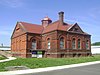
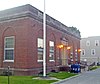
The Fire Alarm, Telegraph and Police Signaling Building, usually referred to just as the Signaling Building, is located on State Street in Troy, New York, United States. It is currently used as storage space by Rensselaer County.

<span class="mw-page-title-main">Hart-Cluett Mansion</span> Historic house in New York, United States

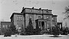
The Hart-Cluett Mansion is located at 57 Second Street in Troy, New York, United States. It was listed on the National Register of Historic Places in 1973, and is a contributing property to the Central Troy Historic District created in 1986. Since the 1950s it, and the Carr Building next door, was the main office of the Rensselaer County Historical Society before the organization changed its name to the Hart Cluett Museum at Historic Rensselaer County in 2019. The house is open to the public as a historic house museum.

<span class="mw-page-title-main">National Register of Historic Places listings in Albany, New York</span>

There are 75 properties listed on the National Register of Historic Places in Albany, New York, United States. Six are additionally designated as National Historic Landmarks (NHLs), the most of any city in the state after New York City. Another 14 are historic districts, for which 20 of the listings are also contributing properties. Two properties, both buildings, that had been listed in the past but have since been demolished have been delisted; one building that is also no longer extant remains listed.

<span class="mw-page-title-main">United States Post Office (Hoosick Falls, New York)</span> United States historic place

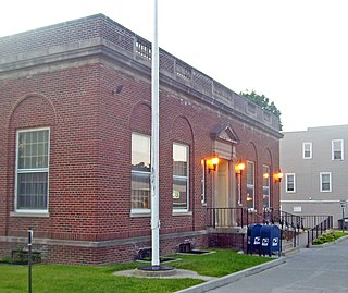
The U.S. Post Office in Hoosick Falls, New York, is located on Main Street a block south of downtown. It is a brick building erected in the mid-1920s, serving the 12090 ZIP Code, which covers the village of Hoosick Falls and surrounding portions of the Town of Hoosick.

<span class="mw-page-title-main">Hoosick Falls Historic District</span> Historic district in New York, United States

The Hoosick Falls Historic District is located in the downtown section of the village of that name in New York, United States. It is an eight-acre (3.2-ha) area concentrated along Church, Classic and John streets south of the Hoosick River.

<span class="mw-page-title-main">St. Mark's Episcopal Church (Hoosick Falls, New York)</span> Historic church in New York, United States

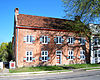
St. Mark's Episcopal Church is located on Main Street in Hoosick Falls, New York, United States. It is a mid-19th century brick building. The congregation itself was founded in the 1830s.

<span class="mw-page-title-main">Hoosick Falls Armory</span> United States historic place

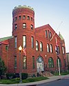
The Hoosick Falls Armory is located along Church Street in Hoosick Falls, New York, United States. It is a red brick building with castellated tower dating to the late 19th century.

<span class="mw-page-title-main">National Register of Historic Places listings in Rochester, New York</span>

This is intended to be a complete list of properties and districts listed on the National Register of Historic Places in Rochester, New York, United States. The locations of National Register properties and districts may be seen in an online map by clicking on "Map of all coordinates".

<span class="mw-page-title-main">Breese-Reynolds House</span> Historic house in New York, United States

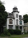
The Breese-Reynolds House is a historic house located at 601 South Street in Hoosick, Rensselaer County, New York.